
BarryStantonGBP
-
Posts
786 -
Joined
-
Last visited
Content Type
Profiles
Blogs
Forums
American Weather
Media Demo
Store
Gallery
Everything posted by BarryStantonGBP
-

2025 Atlantic Hurricane Season
BarryStantonGBP replied to BarryStantonGBP's topic in Tropical Headquarters
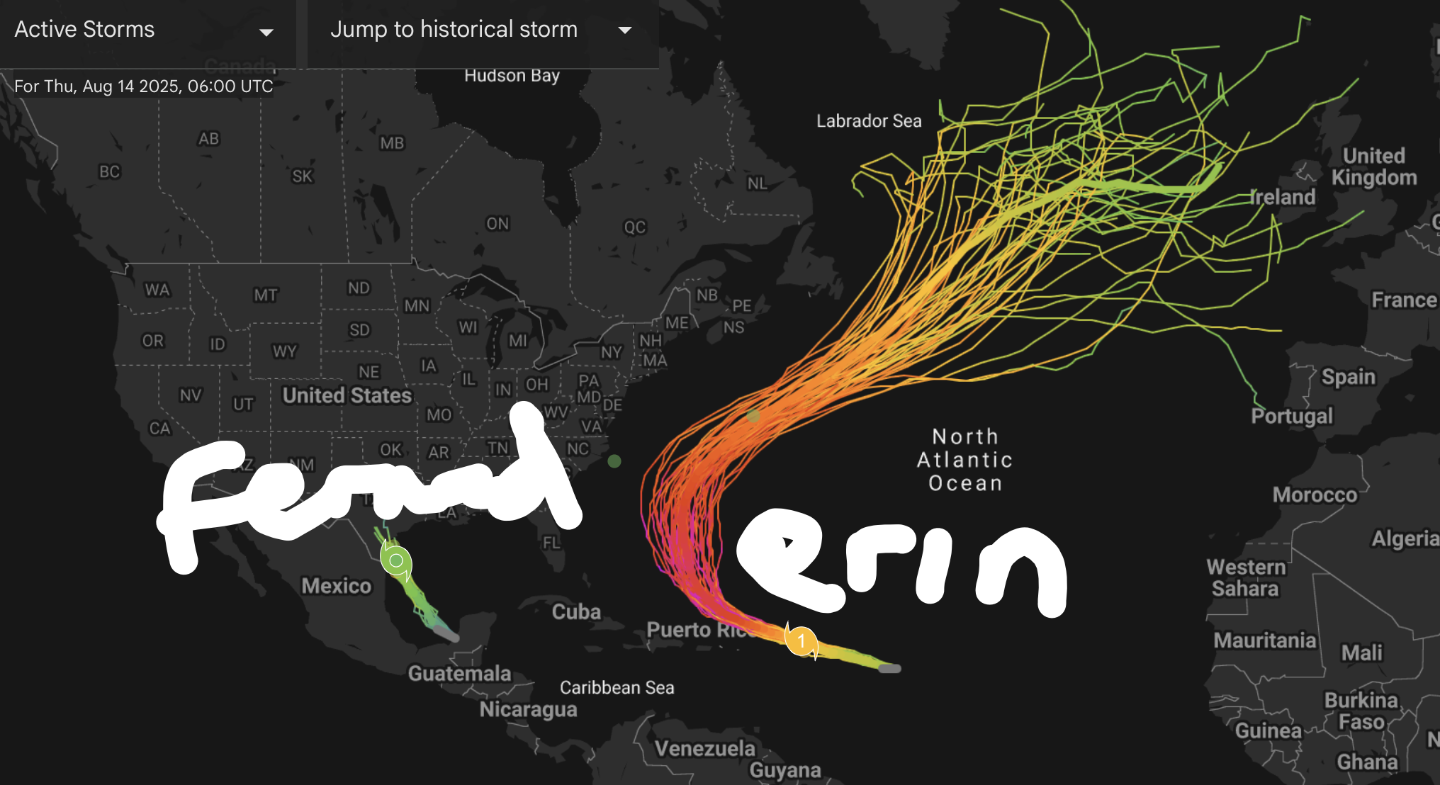
DEEPMINDS UPDATE: Erin expected to peak as a Cat 3-4, safe recurve for the CONUS but Bermuda needs to watch out "Fernand" remaining a weak TS into TX (98L) and could be a category 1 "Gabrielle" becoming an OTS CV recurver (major) "Humberto" forms in the WCAR and vomits in the Gulf (major landfall)
-
2025 Atlantic Hurricane Season
BarryStantonGBP replied to BarryStantonGBP's topic in Tropical Headquarters
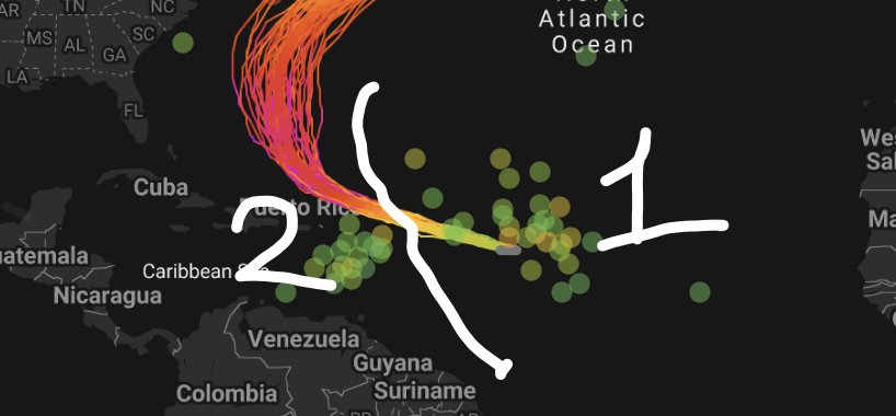
oi lad @GaWx are these 2 waves or 1 wave 0z EPS is slightly more aggressive with this wave, with about 40-50% of the members showing a low. Wide spread from Caribbean to the Bahamas. This run also shows some support for the following wave, on a much more clear-cut recurve pattern (even earlier than Erin), but pretty weak in both support for development and intensity. -
2025 Atlantic Hurricane Season
BarryStantonGBP replied to BarryStantonGBP's topic in Tropical Headquarters
probably gonna be a poundshop erin (dollar store for yous lot) -
2025 Atlantic Hurricane Season
BarryStantonGBP replied to BarryStantonGBP's topic in Tropical Headquarters
sod off -
2025 Atlantic Hurricane Season
BarryStantonGBP replied to BarryStantonGBP's topic in Tropical Headquarters
Somehow I’m not seeing how the euro long term vs the mjo phases match -
2025 Atlantic Hurricane Season
BarryStantonGBP replied to BarryStantonGBP's topic in Tropical Headquarters
-
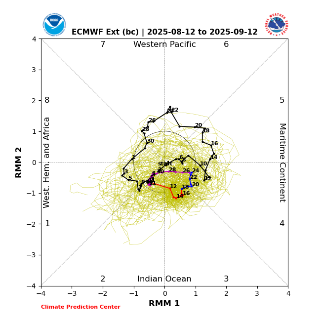
Got this right now but things are subject to change Euro EMON: 11th - 16th August: Phase 2 18th - 30th August: Phase 3 30th - 31st August: Phase 2 1st - 12th September: Phase 1 Euro EMOM: 12th - 19th August: Phase 3 20th - 29th August: Phase 4 30th August - 12th September: Phase 2 BOM: 11th - 18th August: Phase 3 18th - 27th August: Phase 4 28th August - 9th September: Phase 2 NCFS: 12th - 17th August: Phase 2 18th - 22nd August: Phase 3 23rd August - 7th September: Phase 4 8th -11th September: Phase 3, 2, 1, 8
-
@GaWx
-
Title, and you can state how many H and MH would form too If you want, you can even mention names
-
2025 Atlantic Hurricane Season
BarryStantonGBP replied to BarryStantonGBP's topic in Tropical Headquarters
DeepMinds have 2 new waves coming out of Africa: both MH but one heading for the Gulf and the other OTS OTS wave gets named before the WCAR/Gulf wave -
2025 Atlantic Hurricane Season
BarryStantonGBP replied to BarryStantonGBP's topic in Tropical Headquarters
@GaWx i wrote the dates in raw thoughts? Euro EMON:11th - 16th August: Phase 218th - 30th August: Phase 330th - 31st August: Phase 21st - 12th September: Phase 1Euro EMOM:12th - 19th August: Phase 320th - 29th August: Phase 430th August - 12th September: Phase 2BOM:11th - 18th August: Phase 318th - 27th August: Phase 428th August - 9th September: Phase 2NCFS:12th - 17th August: Phase 218th - 22nd August: Phase 323rd August - 7th September: Phase 48th -11th September: Phase 3, 2, 1, 8 -
2025 Atlantic Hurricane Season
BarryStantonGBP replied to BarryStantonGBP's topic in Tropical Headquarters
MJO forecast euro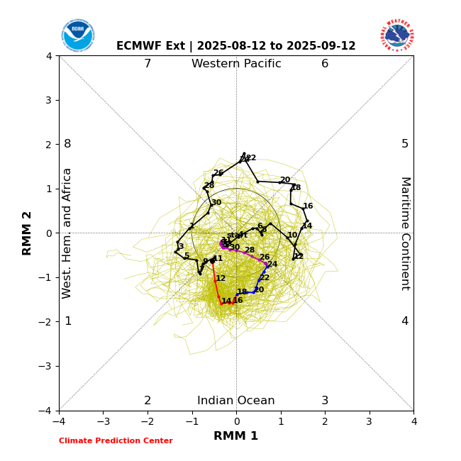
-
2025 Atlantic Hurricane Season
BarryStantonGBP replied to BarryStantonGBP's topic in Tropical Headquarters
Bro, does this mean the next 3 NS are likely weak? I give up if the funniest name is wasted -
2025 Atlantic Hurricane Season
BarryStantonGBP replied to BarryStantonGBP's topic in Tropical Headquarters
I give up The funniest name wasted
-
2025 Atlantic Hurricane Season
BarryStantonGBP replied to BarryStantonGBP's topic in Tropical Headquarters
How much ACE would that be between storms I give up. The funniest name wasted -
Central & Eastern Pacific Thread
BarryStantonGBP replied to Windspeed's topic in Tropical Headquarters
Apparently peak season favours Lilo and Stitch over Gabrielle and Humberto
-
2025 Atlantic Hurricane Season
BarryStantonGBP replied to BarryStantonGBP's topic in Tropical Headquarters
How much NS would that be then just for housekeeping -
2025 Atlantic Hurricane Season
BarryStantonGBP replied to BarryStantonGBP's topic in Tropical Headquarters
All for the bloody peak season energy to go into the EPAC what’s the point -
2025 Atlantic Hurricane Season
BarryStantonGBP replied to BarryStantonGBP's topic in Tropical Headquarters
-
Central & Eastern Pacific Thread
BarryStantonGBP replied to Windspeed's topic in Tropical Headquarters
CAM ON HENRIETTE, BAM BAM, BLOW SOME FAKKIN’ GOALS, CAM ON HENRIETTE, BAM BAM, SMASH RIGHT PAST THEM TROUGHS! -
Central & Eastern Pacific Thread
BarryStantonGBP replied to Windspeed's topic in Tropical Headquarters
WTPA43 PHFO 102032 TCDCP3 Hurricane Henriette Discussion Number 27 NWS Central Pacific Hurricane Center Honolulu HI EP082025 Issued by NWS National Hurricane Center Miami FL 1100 AM HST Sun Aug 10 2025 Henriette’s been givin’ it the big’un today, lads! Proper eye showin’ off on the sat pics and the middle bit’s lookin’ sharper than Harry Kane on a counter-attack. The boffins had her pegged at 65 knots earlier, but she’s clearly upped her game, so we’ll call it a solid 70 kt for now. How strong will she get? Well, the set-up ahead looks sweet. Less of that wind shear nonsense, warmer waters, and cooler air upstairs (whatever that means). Translation: she’s in for a bit of a purple patch over the next day. The “models” didn’t see this one comin’, shock, so we’re gonna go full optimistic and give her near rapid intensification for the next 24 hours, until she runs into rougher conditions and bottles it. By 3 days in, she’ll be out over the cold stuff and get knackered, like England in the second half. Henriette’s leggin’ it northwest at a fair old pace, about 15 kt. Big ridge up top should keep her hoofin’ it in that direction for a few days, until she slows down when she’s had enough. Only change from the last call is she’s leggin’ it faster now, probably ‘cause she’s catchin’ a ride on some stronger winds aloft. FORECAST POSITIONS AND MAX WINDS INIT 10/2100Z 25.7N 152.5W 70 KT 80 MPH 12H 11/0600Z 27.3N 154.3W 80 KT 90 MPH 24H 11/1800Z 29.4N 156.9W 90 KT 105 MPH 36H 12/0600Z 31.5N 159.6W 85 KT 100 MPH 48H 12/1800Z 33.6N 162.3W 75 KT 85 MPH 60H 13/0600Z 35.5N 164.9W 60 KT 70 MPH 72H 13/1800Z 37.3N 167.3W 40 KT 45 MPH...POST-TROPICAL 96H 14/1800Z 41.0N 170.0W 20 KT 25 MPH...POST-TROP/REMNT LOW 120H 15/1800Z...DISSIPATED $$ Forecaster Baz “Up The ‘Pool” Stanton -
Central & Eastern Pacific Thread
BarryStantonGBP replied to Windspeed's topic in Tropical Headquarters
CAM ON HENRIETTE BAM BAM BAM SCORE SOME GOALS LASSIE Hurricane HENRIETTEAs of 18:00 UTC Aug 10, 2025: Location: 25.2°N 151.9°WMaximum Winds: 65 kt Gusts: N/AMinimum Central Pressure: 993 mbEnvironmental Pressure: N/ARadius of Circulation: N/ARadius of Maximum wind: 15 nm64 kt Wind Radii by Quadrant: Hurricane Henriette Satellite | Buoys | Grids | Storm Archive ...HENRIETTE RAPIDLY INTENSIFIES INTO A HURRICANE... ...FURTHER STRENGTHENING EXPECTED... GOOOOOOOAAAAAAALLLLLLL...... 11:00 AM HST Sun Aug 10 Location: 25.7°N 152.5°W Moving: NW at 17 mph Min pressure: 990 mb Max sustained: 80 mph Public Advisory #27 1100 AM HST Forecast Advisory #27 2100 UTC Forecast Discussion #27 1100 AM HST Wind Speed Probabilities #27 2100 UTC Productos en español: (más información) Aviso Publico Pronóstico Discusión Wind Speed Probabilities Arrival Time of Winds Wind History Warnings/Cone Interactive Map Warnings/Cone Static Images Experimental Cone Warnings and Surface Wind -
2025 Atlantic Hurricane Season
BarryStantonGBP replied to BarryStantonGBP's topic in Tropical Headquarters
AND OF COURSE -
2025 Atlantic Hurricane Season
BarryStantonGBP replied to BarryStantonGBP's topic in Tropical Headquarters
Won’t be surprised if this lil fella becomes a pop up The name fernand strikes me as a type to be a pop up -
2025 Atlantic Hurricane Season
BarryStantonGBP replied to BarryStantonGBP's topic in Tropical Headquarters
AFRICAAAAA BAM BAM BAM SCORE SAM FAKKIN GOALS