
BarryStantonGBP
-
Posts
786 -
Joined
-
Last visited
Content Type
Profiles
Blogs
Forums
American Weather
Media Demo
Store
Gallery
Everything posted by BarryStantonGBP
-

2025 Atlantic Hurricane Season
BarryStantonGBP replied to BarryStantonGBP's topic in Tropical Headquarters
K -
2025 Atlantic Hurricane Season
BarryStantonGBP replied to BarryStantonGBP's topic in Tropical Headquarters
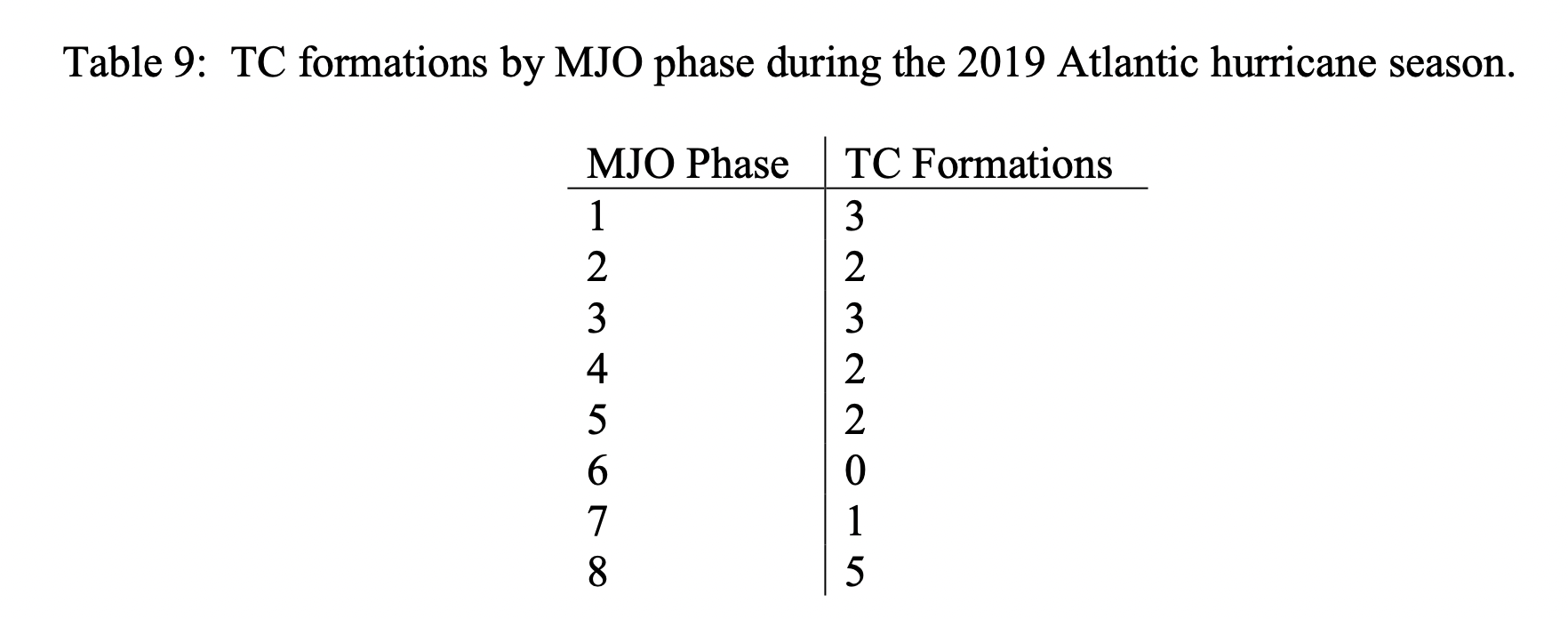
OT but I'm fucking laughing at the fact the phase 7 formation was a fucking 110kts major hurricane in this example A fucking 110kts major hurricane how the fuck does this happen
-
SE Area of Interest--10% two day, 20% five day odds
BarryStantonGBP replied to WxWatcher007's topic in Tropical Headquarters
L 1. Western Atlantic: A large area of disorganized shower activity off the coast of North Carolina and the Mid-Atlantic States are associated with a non-tropical low pressure system. This system is expected to merge with a front and move over cool waters this weekend, and tropical or subtropical development is not expected. * Formation chance through 48 hours...low...near 0 percent. * Formation chance through 7 days...low...near 0 percent. -
2025 Atlantic Hurricane Season
BarryStantonGBP replied to BarryStantonGBP's topic in Tropical Headquarters
-
2025 Atlantic Hurricane Season
BarryStantonGBP replied to BarryStantonGBP's topic in Tropical Headquarters
perhaps, I'd get prepared -
2025 Atlantic Hurricane Season
BarryStantonGBP replied to BarryStantonGBP's topic in Tropical Headquarters
YES. -
2025 Atlantic Hurricane Season
BarryStantonGBP replied to BarryStantonGBP's topic in Tropical Headquarters
-
2025 Atlantic Hurricane Season
BarryStantonGBP replied to BarryStantonGBP's topic in Tropical Headquarters
-
2025 Atlantic Hurricane Season
BarryStantonGBP replied to BarryStantonGBP's topic in Tropical Headquarters
-
SE Area of Interest--10% two day, 20% five day odds
BarryStantonGBP replied to WxWatcher007's topic in Tropical Headquarters
NHS think this not too surprised -
SE Area of Interest--10% two day, 20% five day odds
BarryStantonGBP replied to WxWatcher007's topic in Tropical Headquarters
1. Off the Southeastern United States: A weak area of low pressure located a couple of hundred miles off the coast of the southeastern United States is producing minimal shower and thunderstorm activity. Some slow tropical or subtropical development is possible over the weekend while the system moves northward to northeastward, remaining well off the east coast of the United States. By early next week, the low is expected to become extratropical, ending its chances for tropical development. * Formation chance through 48 hours...low...near 0 percent. * Formation chance through 7 days...low...30 percent. -
2025 Atlantic Hurricane Season
BarryStantonGBP replied to BarryStantonGBP's topic in Tropical Headquarters
I mean, the switch flipped somewhat early this year -
SE Area of Interest--10% two day, 20% five day odds
BarryStantonGBP replied to WxWatcher007's topic in Tropical Headquarters
Are you leaning for or against TC genesis? -
2025 Atlantic Hurricane Season
BarryStantonGBP replied to BarryStantonGBP's topic in Tropical Headquarters
"You need to provide your ID to view this content" -
SE Area of Interest--10% two day, 20% five day odds
BarryStantonGBP replied to WxWatcher007's topic in Tropical Headquarters
So probably we could get a TD but no TS? -
2025 Atlantic Hurricane Season
BarryStantonGBP replied to BarryStantonGBP's topic in Tropical Headquarters
-
2025 Atlantic Hurricane Season
BarryStantonGBP replied to BarryStantonGBP's topic in Tropical Headquarters
This run shows "Gabrielle" and "Humberto" on ket at the very end of the GIF -
2025 Atlantic Hurricane Season
BarryStantonGBP replied to BarryStantonGBP's topic in Tropical Headquarters
-
2025 Atlantic Hurricane Season
BarryStantonGBP replied to BarryStantonGBP's topic in Tropical Headquarters
bob saar -
2025 Atlantic Hurricane Season
BarryStantonGBP replied to BarryStantonGBP's topic in Tropical Headquarters
GFS shows "Fernand" and "Gabrielle" as twins ("Erin" is shown as a weaker storm) -
SE Area of Interest--10% two day, 20% five day odds
BarryStantonGBP replied to WxWatcher007's topic in Tropical Headquarters
Why do you think chances dropped? -
2025 Atlantic Hurricane Season
BarryStantonGBP replied to BarryStantonGBP's topic in Tropical Headquarters
-
2025 Atlantic Hurricane Season
BarryStantonGBP replied to BarryStantonGBP's topic in Tropical Headquarters

-
2025 Atlantic Hurricane Season
BarryStantonGBP replied to BarryStantonGBP's topic in Tropical Headquarters
-
2025 Atlantic Hurricane Season
BarryStantonGBP replied to BarryStantonGBP's topic in Tropical Headquarters