
BarryStantonGBP
-
Posts
786 -
Joined
-
Last visited
Content Type
Profiles
Blogs
Forums
American Weather
Media Demo
Store
Gallery
Everything posted by BarryStantonGBP
-

2025 Atlantic Hurricane Season
BarryStantonGBP replied to BarryStantonGBP's topic in Tropical Headquarters
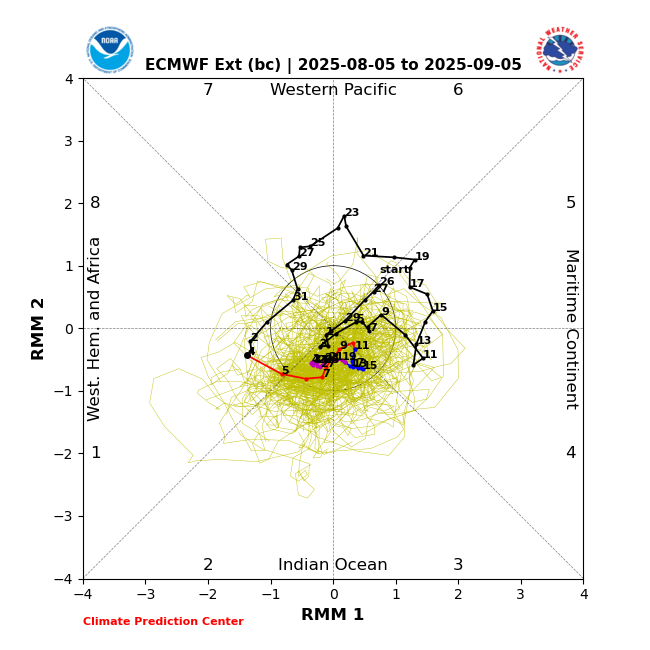
MJO forecasts wave propagation
-
2025 Atlantic Hurricane Season
BarryStantonGBP replied to BarryStantonGBP's topic in Tropical Headquarters
Caribbeans me -
SE Area of Interest--10% two day, 20% five day odds
BarryStantonGBP replied to WxWatcher007's topic in Tropical Headquarters
Next . Off the Southeastern United States: A weak area of low pressure located several hundred miles off the coast of the southeastern United States continues to produce only limited shower and thunderstorm activity. This system is forecast to drift northward over the next day or two before turning northeastward. Environmental conditions now only appear marginally favorable for tropical development into early next week as the system moves northeastward, remaining offshore of the eastern United States. * Formation chance through 48 hours...low...near 0 percent. * Formation chance through 7 days...low...30 percent. -
2025 Atlantic Hurricane Season
BarryStantonGBP replied to BarryStantonGBP's topic in Tropical Headquarters
-
2025 Atlantic Hurricane Season
BarryStantonGBP replied to BarryStantonGBP's topic in Tropical Headquarters
-
Central & Eastern Pacific Thread
BarryStantonGBP replied to Windspeed's topic in Tropical Headquarters
Would be history if it happens -
2025 Atlantic Hurricane Season
BarryStantonGBP replied to BarryStantonGBP's topic in Tropical Headquarters
-
2025 Atlantic Hurricane Season
BarryStantonGBP replied to BarryStantonGBP's topic in Tropical Headquarters
I post model runs. -
2025 Atlantic Hurricane Season
BarryStantonGBP replied to BarryStantonGBP's topic in Tropical Headquarters
-
2025 Atlantic Hurricane Season
BarryStantonGBP replied to BarryStantonGBP's topic in Tropical Headquarters
The switch flipped early asf I won't be surprised if this is the most active ughust on record -
2025 Atlantic Hurricane Season
BarryStantonGBP replied to BarryStantonGBP's topic in Tropical Headquarters
letters are in "speech marks" for illustrative purposes only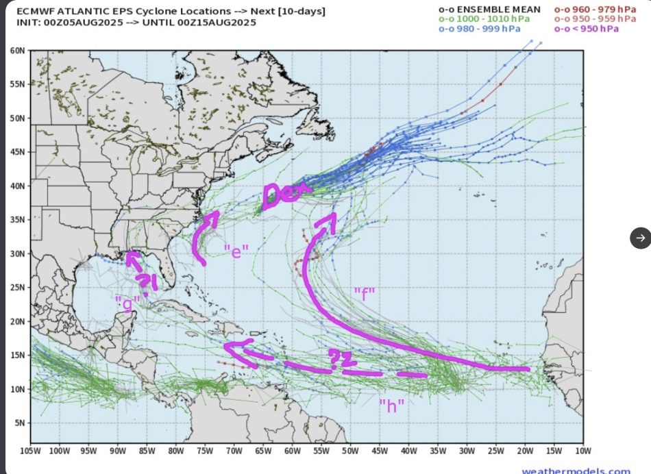
-
Central & Eastern Pacific Thread
BarryStantonGBP replied to Windspeed's topic in Tropical Headquarters
Models show Henriette sightseeing in Shibuya like a lost tourist -
2025 Atlantic Hurricane Season
BarryStantonGBP replied to BarryStantonGBP's topic in Tropical Headquarters
Latest Deepminds (5th August, 6am) Dexter: "Erin": "Fernand" (Dexter copycat): "Gabrielle": "Humberto":


-
SE Area of Interest--10% two day, 20% five day odds
BarryStantonGBP replied to WxWatcher007's topic in Tropical Headquarters
Google DeepMinds has systems all the way from Erin to fucking Humberto -
SE Area of Interest--10% two day, 20% five day odds
BarryStantonGBP replied to WxWatcher007's topic in Tropical Headquarters
1. Off the Southeastern United States: A weak surface trough currently located several hundred miles off the coast of the southeastern United States is expected to form an area of low pressure in a day or so. Thereafter, environmental conditions appear favorable for gradual development of this system, and a tropical depression could form by the latter portion of this week or weekend as as the low initially moves slowly westward, but turns more northward by this weekend. * Formation chance through 48 hours...low...10 percent. * Formation chance through 7 days...medium...40 percent. -
2025 Atlantic Hurricane Season
BarryStantonGBP replied to BarryStantonGBP's topic in Tropical Headquarters
The deepmind ai model had a hurricane making a beeline for Central America recently -
2025 Atlantic Hurricane Season
BarryStantonGBP replied to BarryStantonGBP's topic in Tropical Headquarters
-
2025 Atlantic Hurricane Season
BarryStantonGBP replied to BarryStantonGBP's topic in Tropical Headquarters
quoted from another board -
2025 Atlantic Hurricane Season
BarryStantonGBP replied to BarryStantonGBP's topic in Tropical Headquarters
How many NS? -
2025 Atlantic Hurricane Season
BarryStantonGBP replied to BarryStantonGBP's topic in Tropical Headquarters
Have you seen the latest GFS model with a gulf track bombed out -
2025 Atlantic Hurricane Season
BarryStantonGBP replied to BarryStantonGBP's topic in Tropical Headquarters
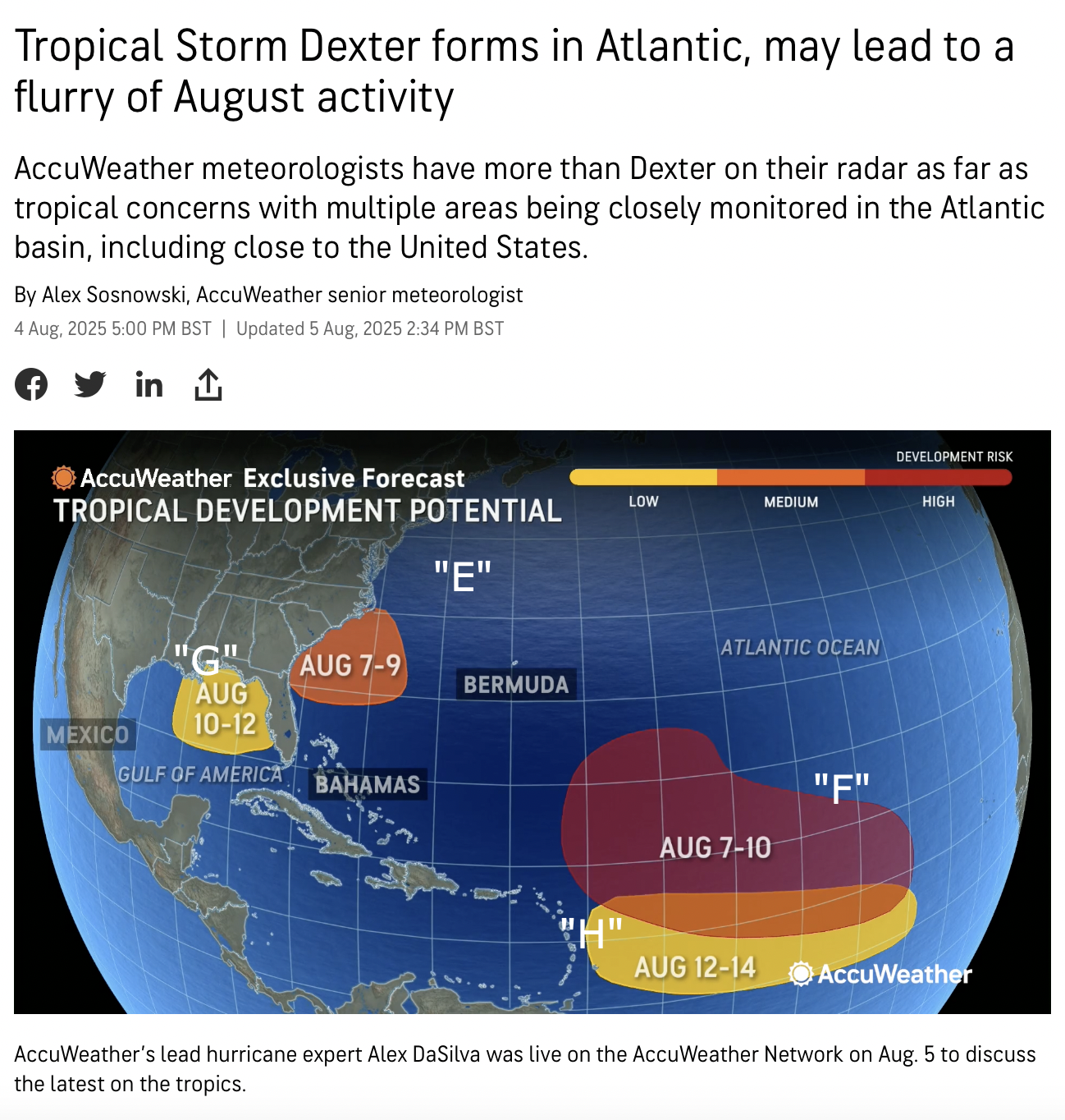
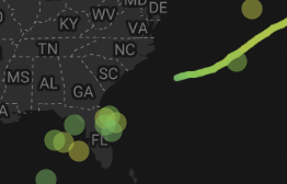
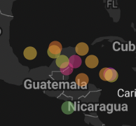
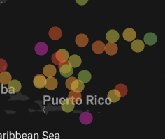
Google Weather Lab: Cyclones (3rd August 2025 edition, goes up to 18th August 2025) NOTE: ALL NAMES ARE IN "SPEECH MARKS" FOR ILLUSTRATIVE PURPOSES ONLY: 95L ("Dexter"): "Erin" - remains weak, curves OTS after FL landfall: "Fernand" - likely from the "African Wave" that's currently 0/40, early recurve, but Bermuda may need to keep an eye out for this one: "Gabrielle" - from an AEW that makes a beeline for Central America: "Humberto" - straight for PR, Cuba, Bahamas: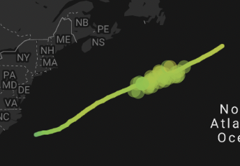

-
SE Area of Interest--10% two day, 20% five day odds
BarryStantonGBP replied to WxWatcher007's topic in Tropical Headquarters
it is ogre chances this develops into a bonafide tc? -
SE Area of Interest--10% two day, 20% five day odds
BarryStantonGBP replied to WxWatcher007's topic in Tropical Headquarters
Hi! 3. Off the Southeastern United States: An area of low pressure could form in a couple of days a few hundred miles southeast of the Carolinas. Some gradual development of this system is possible by midweek as the system drifts to the northwest. * Formation chance through 48 hours...low...near 0 percent. * Formation chance through 7 days...low...20 percent. -
2025 Atlantic Hurricane Season
BarryStantonGBP replied to BarryStantonGBP's topic in Tropical Headquarters
-
2025 Atlantic Hurricane Season
BarryStantonGBP replied to BarryStantonGBP's topic in Tropical Headquarters
HA HA 1. Western Atlantic (AL95): A non-tropical area of low pressure located along a frontal boundary about 180 miles off the coast of North Carolina is producing disorganized showers and thunderstorms. Environmental conditions are marginally conducive for this system to become a tropical or subtropical depression or storm today or on Monday while it moves east-northeastward at about 10 mph, away from the coast of North Carolina. After Monday, environmental conditions become less conducive for development. For additional information, including gale warnings, please see High Seas Forecasts issued by the National Weather Service. * Formation chance through 48 hours...medium...50 percent. * Formation chance through 7 days...medium...50 percent. 2. Central Tropical Atlantic: A tropical wave is forecast to move off the west coast of Africa in the next day or two. Thereafter, some gradual development of the wave is possible during the middle to latter part of next week while it moves generally west-northwestward across the central tropical Atlantic. * Formation chance through 48 hours...low...near 0 percent. * Formation chance through 7 days...low...30 percent.