

NittanyWx
-
Posts
792 -
Joined
-
Last visited
Content Type
Profiles
Blogs
Forums
American Weather
Media Demo
Store
Gallery
Everything posted by NittanyWx
-
A few more along the river in Wilton's downtown:
.jpg.aedf507d299b329cbae051a2710d5449.jpg)
.jpg.73bd4a49008bac02f3a74174cf18aacb.jpg)
.jpg.e7728dc651f9767a250e283a7d15e4fc.jpg)
.jpg.93510dd01df9c0bbf330f0d2b5ce9024.jpg)
-
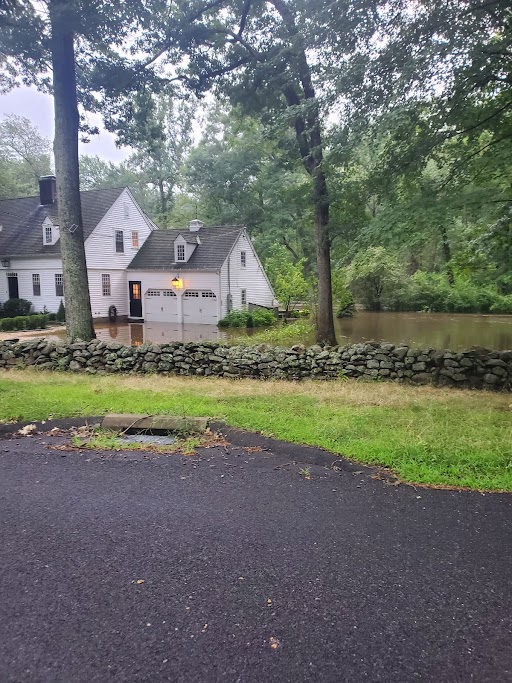
This was by far the worst flooding in at least 40 years along the west branch of the Saugatuck River. Several homes were evacuated last night along the river itself in both Wilton and Westport. As of my drive this morning, the water has crested and is receding. However, water lines ranging from a foot to 3 foot seen on some of these houses. This was a .1% probability of exceedance rain event along the Norwalk River, Housatonic River and Saugatuck. Some photos from yesterday in Wilton and Westport, CT. Please do not redistribute:
.jpg.7c7ffecd41549af0af96335615b1ed0c.jpg)
.jpg.3a984879a4c97762a5f08239339db6b7.jpg)
.jpg.11e552a360a010256195ffe6361975de.jpg)
-

2/13 Significant/Major Winter Storm Discussion & Observations
NittanyWx replied to Northof78's topic in New York City Metro
Depends on which coast, CT did well with this. -
2/13 Significant/Major Winter Storm Discussion & Observations
NittanyWx replied to Northof78's topic in New York City Metro
Wilton, CT Final total: 8" -
2/13 Significant/Major Winter Storm Discussion & Observations
NittanyWx replied to Northof78's topic in New York City Metro
The winner ended up being that merritt/287/91/84 box after all. The loser is me for bitching out about it last night after the HRRR. Shoulda stuck with original call. -
2/13 Significant/Major Winter Storm Discussion & Observations
NittanyWx replied to Northof78's topic in New York City Metro
Wilton, CT - 11:35 32/32 7.5" -
2/13 Significant/Major Winter Storm Discussion & Observations
NittanyWx replied to Northof78's topic in New York City Metro
10:45 AM - Wilton, CT 31.7/31 6" flat -
2/13 Significant/Major Winter Storm Discussion & Observations
NittanyWx replied to Northof78's topic in New York City Metro
Snow rates have been about 1.5"/hr since 7 AM up here -
2/13 Significant/Major Winter Storm Discussion & Observations
NittanyWx replied to Northof78's topic in New York City Metro
9:30 am - Wilton, CT 31/30 5" Even accumulation Kicking myself for biting on the Euro/HRRR last night up north. -
2/13 Significant/Major Winter Storm Discussion & Observations
NittanyWx replied to Northof78's topic in New York City Metro
As far as the Euro/HRRR goes, this is one of the worst performances inside 36 hours I can remember. -
2/13 Significant/Major Winter Storm Discussion & Observations
NittanyWx replied to Northof78's topic in New York City Metro
Wilton, CT 8 AM Obs 31/30 3" even on the ground -
2/13 Significant/Major Winter Storm Discussion & Observations
NittanyWx replied to Northof78's topic in New York City Metro
It was mentioned several times that this would occur. The accumulations for this storm will likely double on non-paved surfaces. -
2/13 Significant/Major Winter Storm Discussion & Observations
NittanyWx replied to Northof78's topic in New York City Metro
Impressive stuff up in orange. This has been one of the weirder 24 hours leading into a storm in my career. Raising the totals for city and Island was right to do, but biting on the N/W sharp cutoff as a function of near term trends was not. -
2/13 Significant/Major Winter Storm Discussion & Observations
NittanyWx replied to Northof78's topic in New York City Metro
4-8" looks good for most (obviously less up by 84 and just north), again with the pavement caveat in urban areas and NYC. No need to fight the southerly trend this late. The returns in Tennessee weren't great this afternoon and think the trend south is a response to that. -
2/13 Significant/Major Winter Storm Discussion & Observations
NittanyWx replied to Northof78's topic in New York City Metro
Was on the phone with my old boss this morning, told him 6" in that north shore snow zone is probably reasonable top end. But it's a snow board 6", i think a lot of 2-4", 2-5" readings mostly on grass -
2/13 Significant/Major Winter Storm Discussion & Observations
NittanyWx replied to Northof78's topic in New York City Metro
Think you can go in the middle of the two ranges and be fine. This storm is very juicy, but very marginal too. Snow board will do better than 'on ground' It won't look or feel like 3-6" for a bunch of folks in the city (more than manhattan too, brooklyn et al). -
2/13 Significant/Major Winter Storm Discussion & Observations
NittanyWx replied to Northof78's topic in New York City Metro
Coastal marginal temps/mixing keep things at bay accumulation wise. it'll look nice for a period, you'll get some accumulation on grassy surfaces, but a lot of it will feel 'wasted'. It's still better than what it looked like a couple of days ago. This is game on north of the merritt/287. -
2/13 Significant/Major Winter Storm Discussion & Observations
NittanyWx replied to Northof78's topic in New York City Metro
Similar thinking, pending 12z adjustments in track. I like this a lot in the 287-84-merritt-91 box -
2/13 Significant/Major Winter Storm Discussion & Observations
NittanyWx replied to Northof78's topic in New York City Metro
taking under on that 12" by a significant margin -
2/13 Significant/Major Winter Storm Discussion & Observations
NittanyWx replied to Northof78's topic in New York City Metro
I like this a lot for north of 287/Merritt, though a large chunk of our area is gonna waste some of the overnight precipitation to sleet and mix at the onset with the warm nose above 850 and best diurnal timing. This is a frustrating one for the coast, especially the island, but that's often the issue in marginal storms like this one. -
There is also tangential/research being done on what impact any SSW event has on the actual PV and the spatial distribution of 2m temperature anomalies/h5 pattern. There are statistically higher odds of certain loading and post event patterns depending on whether a displacement or full split event occurs.
-
Tropics Check
-
Once again, a clean eastward propagatation in subsidence...the models handled this well.
-
OLR/VPA tracking:
-
Background


