stormy
-
Posts
2,000 -
Joined
-
Last visited
Content Type
Profiles
Blogs
Forums
American Weather
Media Demo
Store
Gallery
Everything posted by stormy
-
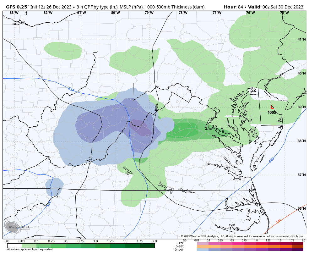
On Sunday afternoon I said, "Don't be too quick to give up on Friday". The 12z GFS now agrees: Only a snapshot in time, but we'll see.
-
At 192 that low is at least 75 miles too far north/northwest for D.C..... It should be closer to Cape Charles.. That type of track would be ok for west of the Blue Ridge.
-
Merry Christmas!!!!!!
-
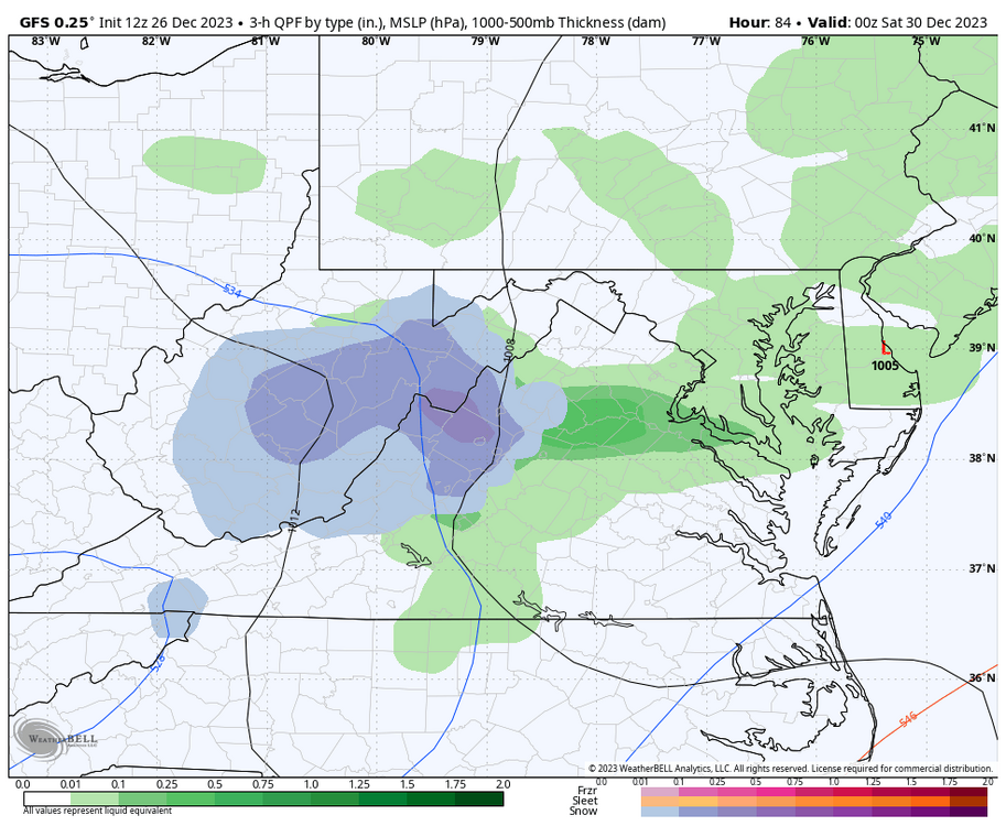
Don't be too quick to give up on Friday. The Midwest gyre gives many of us soaking rain on Tuesday and Wednesday. As the upper level energy moves across Virginia on Friday, timing and a little more consolidation could give some areas a snowfall similar to Dec. 11. Only a weak surface reflection offshore and no real source of cold air to draw from tend to stack the deck, but this system carries adequate cold air. Slow it down and add a little more juice could turn the trick, something like planting surface LP over Norfolk at 10 pm Friday.
-
Wow!! Both the ECM and GEM give much of Augusta County 2 inches of rain during the next 168 hrs.. This Nino is producing. Many Valley folks have been praying for a wet Winter. December is making a solid contribution.
-
Yesterday afternoon, the 18z GFS op. made some flawed assumptions IMO that culminated in a major snowstorm for our region around Jan. 6 - 7. IMO, a very erratic track would not survive the test of time and I so stated my opinion. It did not survive the test of time. Period, Stop The period between Dec. 28 - Jan. 10 should be active and produce some snow for most of us. I believe most of us agree or at least hope for this reality. Accurate details are not available at this early date. Early speculation will likely change, but that is ok for those who wish to speculate. I will not criticize those who throw cold water on my ideas. Everyone is entitled to an opinion. Enjoy your life and now I begin a busy day.
-
You missed the erratic LP gyrations, Beckley s.w. to Ashville to Charlotte. Cad on steroids? Wait until tomorrow morning.
-
I am happy for all the Snow Geese who are honking !!!! The op. GFS is very erratic with the track of L.P. during the 336 - 378 hr. timeframe. This is not likely to survive. During the past week, we agreed that looking beyond 300 hrs. on an op. is foolish. The GEFS does believe that L.P. will be developing in N.C. at 7 am on the 6th, transferring to eastern N.C. and eastern Va. at 1 p.m. That can be a good sign.
-
Guess what? The 18z GFS now transfers energy south at the last minute, and dumps snow on Jan. 6. 8 inches for me and 11 inches for D.C. by Sunday morning. My wish with psu nearly came true!!!!! Hooray!!!!
-
Hey, guess what, we agree! For the past 2 hrs., I have been rather foolishly grilled because I simply told the truth about the Euro package today. Many folks seem to be very protective of their desires which is rather juvenile. As long as others support their dreams, everything is wonderful. Unfortunately that is not the reality of life. In truth, life can be a bitch and then you die. Hopefully, the 00z run of the EPS gives D.C. 12 inches of snow on the 5th. Have a good night and as always, I appreciate your opinion.
-
Please be realistic, your insinuation demeans your normal demeanor.
-
Oh sure. I often look at the 500 mb height anomaly, 500 mb windspeed, Surface temp., 850 mb. temp, 850 mb. run to run change, mslp precip. 6n hr., prob. mslp - 1005hpa. among others depending on availability. To make a long story short, the 12z Euro package was not excited today through Jan. 5 regarding any significant wintry threat. Tomorrow, it might explode!
-
We're looking at what the model or ensemble says at a given point in time. We are not fantasizing about what some people dream of. Sure, we have good chances in early January. Be patient, wait until tomorrow, the model of your choice may look better. Don't condemn today because it doesn't satisfy your wishes.
-
Thanks, but Yes, we are looking for different things. My comment said "no significant winter weather". This is all subject to monumental change, but at the point in reference, I don't consider .2 inch of snow to be significant.
-
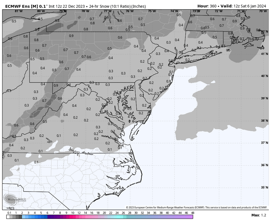
I totally agree that it is too early to give up on early January. I am invested in January 3 - 6. The ECM/EPS runs may look much better tomorrow. The joy of this hobby is like the weather in New England. "If you don't like it, wait 10 minutes and it will change".................
-
The third word of your comment says it all: ignore ....... Have a better day tomorrow.
-
You are correct. Instead of splitting between 240 and 360 hrs.. I decided to lump the two in tandem, covering the period up to Jan 6. This has both covering the 29 threat and the EPS the 29 & Jan 5 threat.
-
The 12z ECM and EPS say no significant winter weather through Saturday, Jan. 6. Everything is too progressively zonal.
-
I really enjoyed reading the long ago memories from PSU this morning. You should finish that met. degree at some point. The personal reward would be tremendous. This caused me to reflect on many memories of my own of snowstorms all the way back to the 60's. Though very young, I have fleeting recall of the March 5 - 8 1962 "Ash Wednesday Storm" that dumped 30 - 36 inches in my area. We were snowbound for several days before a bulldozer opened our road. Late Jan. of 66 gave us 37 inches in 7 days from 3 storms with 10 ft. drifts. Every highway in Augusta County blocked with drifts on Sunday, Jan. 30. Regarding the GFS for the 29th, taken literally the op. gives me 5 inches at 10:1 but the surface temps at 36 - 37 degrees at the 1201 Ft. Valley Airport would likely make this an accumulation elevation event mostly above 1500 ft. even in pre-dawn darkness.
-
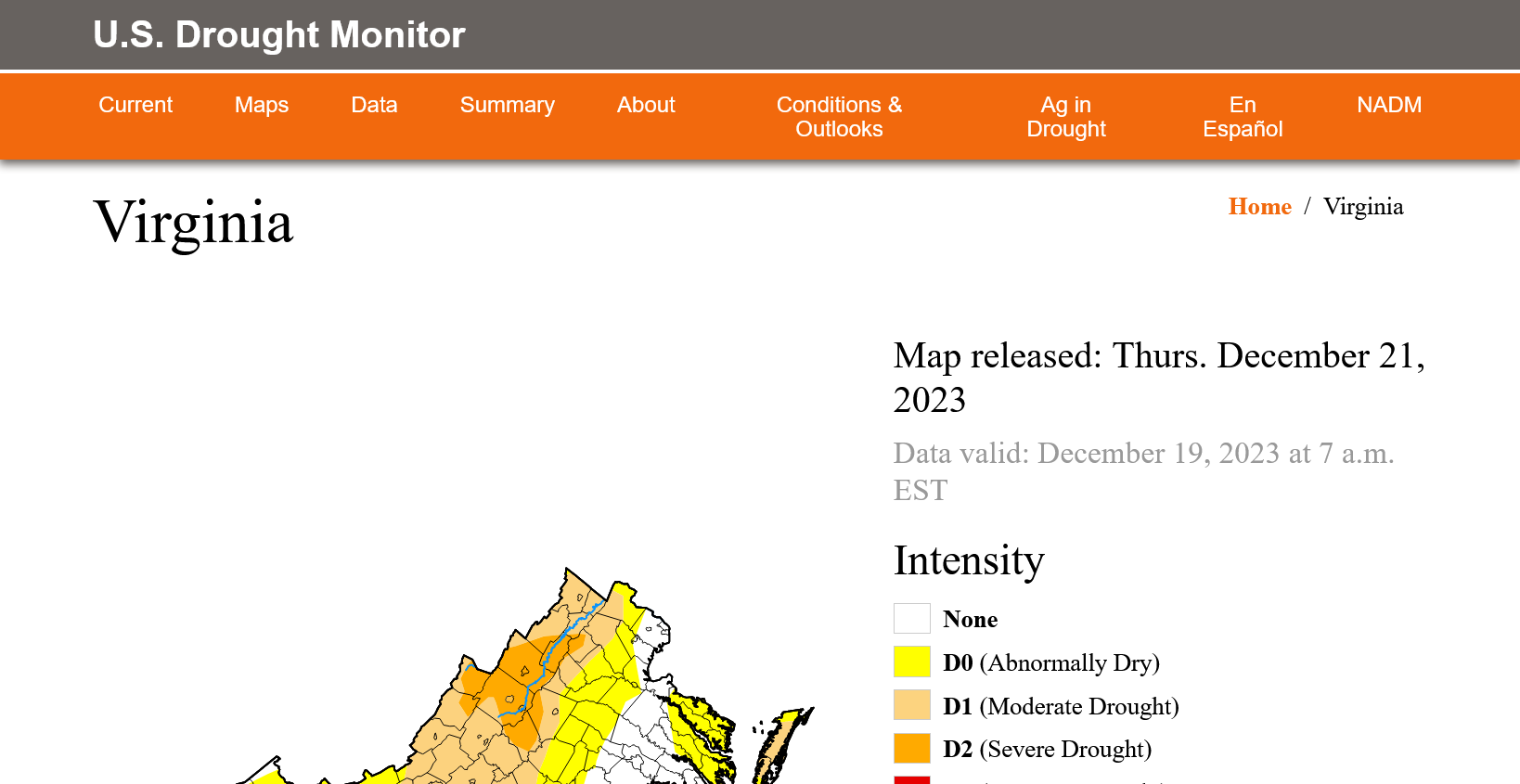
Much of the Valley is still in severe drought.

-
The 12z deterministic GFS gives warning criteria snow to the 81 corridor in the Jan. 4 - 6 time-frame. This of course will all change but I see this as a determination of pattern. The 21 members of the GEFS give basic agreement to the pattern, but as earlier this week and last, it disagrees with its own parameters if looking at literal precip. type. That is a repetitive flaw with this ensemble. The 12z EPS is superior to the GEFS in this regard.
-
The 00z and 06z guidance is looking good for a colder, unsettled period during Jan. 1 - 5. 17.8 degrees this morning.
-
I am on record as liking the first 5 days of January, for unsettled wintry conditions across the MA. Cold air will be settling south from HB. The STJ should be amplifying.
-
14 degrees early this morning in Augusta County.
-
That would be workable with about 170% of normal rainfall. We'll get our heavy snow later in Feb. and March.