

09-10 analogy
-
Posts
1,138 -
Joined
-
Last visited
Content Type
Profiles
Blogs
Forums
American Weather
Media Demo
Store
Gallery
Posts posted by 09-10 analogy
-
-
2 minutes ago, George BM said:
Just had quite a bit of dime to quarter-sized hail with that western Fairfax county storm.
You can keep it.

-
 1
1
-
-
First thunder. Would prefer no hail. If I had a garage I wouldn't care, but ...
-
 1
1
-
-
2 minutes ago, Wxtrix said:
we’re set up on the hotel’s patio. we’ve got lunch, wifi, bathrooms, and a good view of the sky. our initial choice had too many trees blocking the sky.
Yeah that’s what’s nice about our spot too: a lot of open sky
-
1
-
-
On eastern shore of Oneida lake northeast of Syracuse. Sun through high clouds nowbut there’s mid level junk all around. Real nice location in a state park though with facilities and good visibility (other than clouds). We got here at around 8 with about 10 cars in tile lot. Hiked around the park a bit and came back to the lot more or less full. I’d say lot has room for 200 (WAG) cars
-
1
-
-
We're still going. Compelled by my daughter, who now is expecting a visit. (Nice to still be wanted.) If the clouds get in the way, so be it. We're still going to the state park and will have fun hiking around and having a picnic, even if the eclipse doesn't pan out to perfection. The room we've got in Utica is reasonably priced. I'm just once again worried about the traffic but if a little bit of cloud keeps some margin of viewers off the road, that might be a tradeoff I'm willing to make. We're also looking at an alternate state park that backs onto the Tug. I've always wanted to go there, but of course during a lake event.
Frankly, the worst part will be what it usually is: the drive up 81. Trucks to the galore, half the time a lane is closed for repaving or other construction, causing backups that would make 95 over the Occoquan proud. The drive through the mountains was fun the first couple times, but that novelty has definitely worn itself down to a nub.
-
2
-
-
There's a whole menu of model options regarding cloud cover that this forum usually ignores or, in my case, didn't even knew existed.
We decided to decamp NE of Syracuse in a state park near Oneida Lake. Might try to go more NW if the traffic isn't bad to get an extra minute of Totality.
Of course I've got to be in on a meeting Tuesday that I really can't do in a car. I tried dropping the magic words "eclipse" and "daughter" to get out of it, but no go.
-
-
Yeah just sharing the experience with our daughter is the big thing. The ZoT is only 15 or so miles away from where we're staying so if the traffic isn't that bad we'll tool on up to Rome or something. But I hate traffic; deal with enough of that around here. And I hate port-a-potties. And I don't like doing my number-one business on some stranger's property without their permission.
-
We got a hotel room where it's 99.7% totality, in Utica. Our daughter goes to school up near there so we're hooking up with her since her friends can't get their act together to see it. I think we're just going to stay at the hotel and if we miss out on 0.3%, it'll be worth it to have access to a bathroom and not worry about traffic. One thing giving me a little pause is the NWS threat matrix product, which shows 49% sky cover for Monday for Utica at 12 pm. But the p-and-c forecast is mostly sunny.
-
1
-
-
The "triple point" is the severe season's kin to winter storms' "deformation zone."
-
47 minutes ago, Eskimo Joe said:
Per the MD 344, the extraordinary shear seems to be quite capably overcoming the lack of instability in WVA, so if that's occuring upstream of us ..?
-
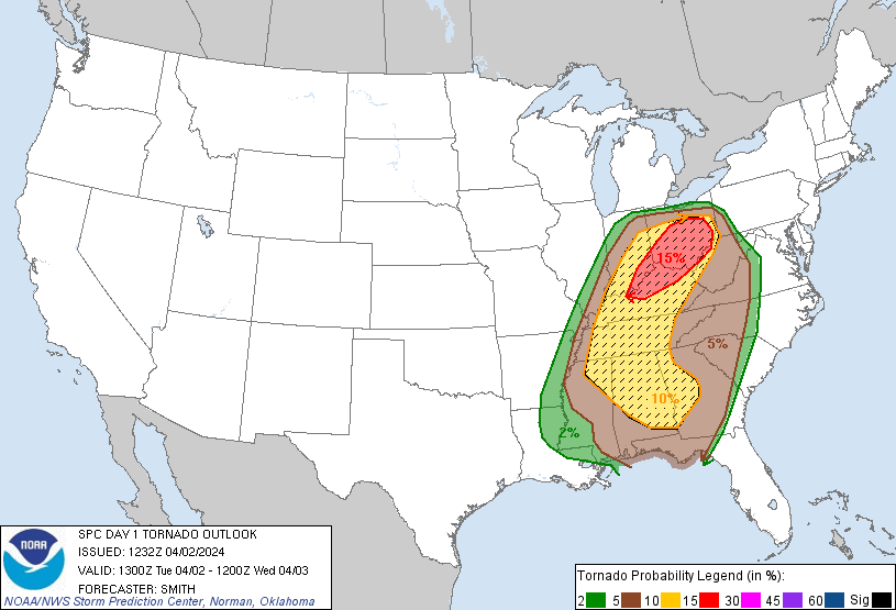
Somewhat ironic, or eerie, or maybe just uselessly coincidental, that the overlay for the hatched 10% significant tornadoes today covers almost exactly the location of the vast majority of tornadoes of Superoutbreak I, whose 50th anniversary is tomorrow.
-
3
-
-
This Burnes guy is everything that was advertised. I could get used to this every fifth game.
-
4
-
-
Well they expedited the Minneapolis I-35 bridge so that it only took 13 months to rebuild (https://www.cnn.com/2024/03/27/economy/minneapolis-bridge-collapse-baltimore-lessons/index.html) but that bridge was only a quarter of the length of the FSK.
-
Evidently the cargo ship issued a "mayday," which was relayed to the bridge authority, allowing it to stop vehicular traffic and preventing a potentially greater loss of life. That's from the news conference they held.
-
6
-
-
Yep was not expecting thunder with these lower temps. Not just this low rolling stuff, but a legit timpani. There's some decent lightning with this cell, too. And a downpour that wouldn't be out of place in August.
EDIT: Just saw the p n' c from Sterling mentions "small hail."
-
1
-
-
Damn, the Tahoe webcam is down. At least for me.
-
1
-
-
7 minutes ago, SnowenOutThere said:
If you have any old AFDs from our blizzards saved please do share them as unfortunately I am too young to have been able to read of them live...
Go to:
https://mesonet.agron.iastate.edu/wx/afos/list.phtml
They've got AFDs archived even back to 2003. Pretty complete archives for 2016 and 2009-10. Just use the drop-down menus.
-
1
-
-
9 hours ago, George BM said:
Forecast Discussion
Saturday, March 16, 2024 3:28PM EDT
Blizzard Warning in effect from 8AM EDT Sunday, March 17, 2024 until 3PM EDT Monday, March 18, 2024
High Wind Warning in effect from 9AM EDT Sunday, March 17, 2024 until 6PM EDT Monday, March 18, 2024
Hurricane Wind Warning in effect from 2PM EDT Sunday, March 17, 2024 until 6AM EDT Monday, March 18, 2024 (for tidal-Potomac and Chesapeake Bay)
Life-Threatening Late-Winter Storm to cripple to region.
Temps are currently holding in the mid-50sF across the DC metro area but are already starting to fall in far northern Maryland as the cold front associated with the strong northern stream system drops south through the region. Temps will plummet out of the 50s and through the 40s and 30s through the evening and reach the lower 20s in many areas by morning as the unusually cold airmass pushes in. As this occurs through the late afternoon and evening hours skies will become overcast both from lift associated with the southward moving cold front and from the strong southern stream system to our south/southwest. There may be enough lift and moisture associated with the front for some light sprinkles and/or a few flurries/light snow showers to develop through the evening before precip slips to the southeast. Northerly winds will become quite gusty during this time with gusts of 25 to 40 mph.
As the strong southern storm system moves toward the coastal Carolinas tonight it will begin to phase with a second powerful northern stream vort diving south from the eastern Great Lakes/ Toronto region leading to strong diffluence over the surface low leading to rapid deepening. The two will pinwheel around each other as they phase bringing the southern storm and associated surface low northwards as rapid deepening takes place allowing snow to overspread the region by morning from southeast to northwest. The snow will quickly become heavy as NE winds increase with gusts to over 50 mph across the region likely by midday. Temperatures during this time will be in the lower 20sF leading to windchills in the single digits. By the late afternoon/evening the surface low will slow down and eventually stall over the Virginia peninsula/ southern Chesapeake Bay area. The surface pressure could be as low as the mid-950s in millibars breaking monthly low-pressure records in that area. Meanwhile, the areas northwest of the surface low (the greater Washington DC and Baltimore metros) will be getting the worst of this storm with blinding snowfall and widespread 60-75+ mph wind gusts w/ 80-90+ mph gusts along the coast of the Bay. In fact, snowfall rates in the heaviest bands will likely be in the 4-6”+/hr range leading to visibilities as low as 50 feet (effectively zero visibility for the sake of argument) from the late afternoon hours through the night and into Monday morning. Temperatures will remain in the 20s throughout the duration of this event with upper teens possible in the higher elevations north and west and temperatures closer to 32F in far southern MD and along the bay where warmer air will be located near the surface low. Windchills during the duration of the event will stay in the single-digits for most w/ negative single-digits in the mountains and lower teens in southern MD and along the bay.
Near-whiteout and conditions and severe wind gusts will still be ongoing by dawn Monday as the low-pressure system slowly pulls northeastwards. Heavy snow will continue through the late morning to midday hours before tapering off from west to east. When all is set and done with total liquid-equivalent precipitation of 4-7”+ across the region, snowfall totals of 4 to 6 FEET will likely be commonplace with snow drifts of as high as 30 feet possible. Areas in southern MD and near the Bay may end up with slightly less (roughly 2 to 4 feet) as the warmer air associated with the low-pressure center cuts down on totals in that area.
This will be the worst blizzard, by far, to impact the region since weather records started in the later 1800s. It will essentially be a high-impact hurricane with snow instead of rain as the main precip-type. People who venture outside during this time may get disoriented and lost in the whiteout conditions and/or get seriously injured by flying debris. Emergency services may not be able to reach you for days should something happen to you outside. This is the DC and Baltimore urban corridor not Lake Tahoe or the Japanese Alps. We’re not equipped with the snow removal equipment that they have. So, if you absolutely must venture outside during the storm no caution that you use would be too extreme given the circumstances.
Temperatures will only rebound to the lower 30s as skies start clearing by mid to late afternoon on Monday.
Forecaster Wannabe: George BM
You must have been inspired somewhat by the ongoing Sierra storm for this one!
")
Here's an "off-the-reservation" AFD out of Reno this morning:
https://www.weather.gov/wrh/TextProduct?product=afdrev
They broke the "fourth wall" in some phrases for this edition.
I'd think with something like you describe, the authorities would implement a curfew. Now there's an AFD that's be a keeper: "We'd urge people to stay inside during this weather emergency, but the authorities with their "shoot-on-sight" curfew have taken care of that one."
-
3
-
 1
1
-
-
23 minutes ago, Random Chaos said:
If you’re not familiar with Maryland’s lidar map, it includes DC and is awesome: https://geodata.md.gov/topoviewer/
Thx for that. The (in)famous Parrs' Ridge shows up real well on it.
-
1
-
-
Snoweenitus is a perilous condition to have when you live inside the Beltway.
-
1 hour ago, NorthArlington101 said:
Look at the north Arlington perks. On this map you get to basically be in Fairfax county
Yah just like I get to basically be in Montgomery County.
-
1
-
-
Liking the trend. I'm all in on the Tenleytown Massif reaching 5". And given the insomnia I've been having recently, I ought to be up for it. Watch tonight be the *one* night when I get continuous stage 3 sleep, though. So better stay up and drink so I'll be there, if not coherent, for the ETA.
-
BIg fat flakes with the best rates so far and the wind is ticking up. Observable stickage ought to commence soon. It may be now but it's hard to see out of my rain-covered window.
EDIT It is sticking on car windows and *some* grassy weenie areas.
2024 Severe Weather General Discussion
in Mid Atlantic
Posted
Pocket of 9 C/km LLLR SW of DC according to latest SPC mesoanalysis.