

SomeguyfromTakomaPark
-
Posts
5,458 -
Joined
-
Last visited
Content Type
Profiles
Blogs
Forums
American Weather
Media Demo
Store
Gallery
Posts posted by SomeguyfromTakomaPark
-
-
2 minutes ago, stormtracker said:
Looks liike a legit blizzard. Holy ****. 958mb
Snow hurricane omg
-
3 minutes ago, LP08 said:
What a monster brewing though at 192
Oh man that's tasty looking, trough about to go negative...
-
4 minutes ago, Solution Man said:
Yeah, this was brutal, looks like qpf was good but synchronization of cold air was not. I believe the HRR keyed in on this last night. What’s your thoughts?
HRRR was not good. Last night when I went to bed it had a 4 hour+ period of snow for DC. I think the Euro did the best here.
-
Ooooof, that rain/snow line is WAY north of here. Oh well, can’t win ‘em all.
-
38 minutes ago, losetoa6 said:

That’s well within the possible error of a 60 hour forecast. Let’s get that moderate snow back to about leesburg, 2-4 inches for all.
-
 1
1
-
 1
1
-
-
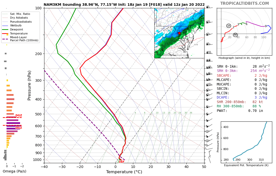
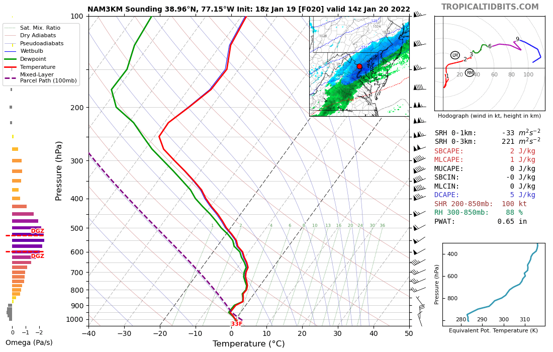
12 minutes ago, MN Transplant said:
7am and 9am soundings from my area of the NW DC Beltway.


That’s a nice snow sounding! Should be a fun morning.
-
3 minutes ago, yoda said:
18z NAM shifted SE a smidge with its heaviest totals

3K is nice for the metros too....3-4 DC to Baltimore.
-
I have a feeling this one trends back us. 2-4 inches DC and SE.
-
 1
1
-
-
NAM looking great for DC - 2 inches by 10 am and dumping.
EDIT: 3 inches on the 10:1 maps.
-
2
-
-
1 minute ago, NorthArlington101 said:
take this for the very little bit this is worth, but the 18z EPS didn’t totally cave - it’s really pretty identical to 12z but slightly more suppressed

Were still in the game. This could easily come north and give us a solid advisory event.
-
7 minutes ago, jayyy said:
You’re not dreaming. Still well within range to see enough of shift north to see advisory / low end warning snowfall in the metro corridor and points ESE. Some models already showing it, although it would be nice to see an appreciable trend begin at 18z or 0z tonight Writing the storm off this early when models are still all over the place with the 500mb setup is silly
Give me a bob chill 3-6 type event with temps in the upper teens and 20s and I’m happy as can be. This is just after the mid point in January in the mid Atlantic and we’re talking about events #4 and 5 hitting by the end of this week. People Complaining about that is ridiculous, I’m sorry
The need for some to see a MECS or HECS potential with every coastal is honestly pretty annoying.
Yeah man, snow before an arctic dump is rare and awesome here. 13 degree lows on dry brown frozen landscape is lame. Also I love it this time of year because the sun angle is still low and we can hang onto a snow pack.
-
3
-
-
5 minutes ago, LP08 said:
I know it’s the NAM but it looked to be doing something completely different than other runs. I’m too dumb to guess.
It’s intriguing. I like seeing precip in Georgia like that.
-
Just now, stormtracker said:
Uh, that's basically what the 12z Euro is showing.
Looks like 2-4
This would be a good event. It is of course trending away from a monster and of course it could trend way suppressed but it's only Tuesday. We're in the game for a snowstorm still.
-
Just now, stormtracker said:
Time for the Varsity models
JMA looks better at 72.

I'll see myself out...
-
4
-
-
1 minute ago, Ralph Wiggum said:
We do disaster pretty well wrt tracking winter storms, so there's that.
So far not this year….I have received about 16 inches of snow and we’re just about halfway through January.
-
2
-
-
1 minute ago, Weather Will said:
WB Control…. Not that good


6 inches of cold smoke not that good lol….I’ll sign on the dotted line right now.
-
4
-
-
3 minutes ago, BristowWx said:
just hang your hopes on the sampling issue...that will get you through until its sampled then panic...does beg the question where does the euro get it's sampling data or is it just better at extrapolating...or none of those
Yeah I mean we’re almost in NAM range and they’re still pretty far apart. Like I said, euro and eps have been locked in now for several runs with minimal wavering so that’s where my money goes but it certainly is edge of your seat entertainment.
-
Gosh we are getting close in for the euro to be this far off from everything else….my money is on gfs folding at 12z today.
-
6 minutes ago, Ji said:
Wow


10 inches on the mean! Holy smokes.
-
3
-
-
Canaan is up to 16.4 as of 7pm.
-
1
-
-
13 minutes ago, jaydreb said:
EPS at 120 should be money, right?
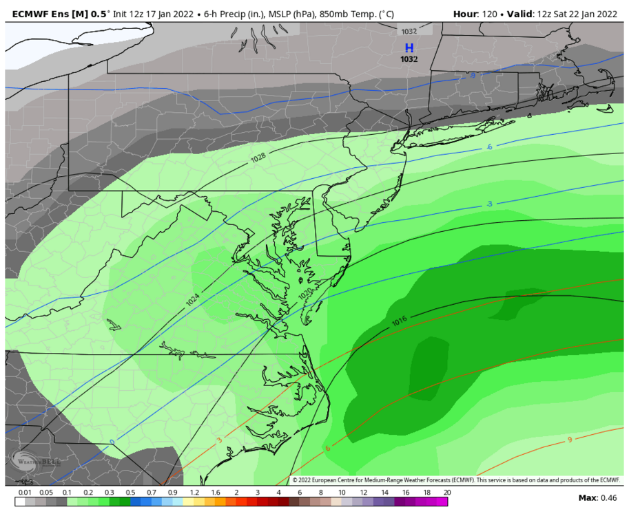
That’s a classic looking panel. From this range EPS/euro should be money. I’m going down with them if they’re way off.
-
The webcams from whitegrass in Canaan valley are showing an absolute blizzard right now.
-
1
-
-
10 minutes ago, yoda said:

Oh good god yea! That’s a solid run!!!!
-
Man looking at the radar and hearing the wind I feel like we’re about to get a severe thunderstorm warning.


Late January and February Medium/Long Range Discussion
in Mid Atlantic
Posted
Isn’t that just about the ideal position of the ridge over the Rockies for us?