

SomeguyfromTakomaPark
-
Posts
6,190 -
Joined
-
Last visited
Content Type
Profiles
Blogs
Forums
American Weather
Media Demo
Store
Gallery
Posts posted by SomeguyfromTakomaPark
-
-
Pretty cool to have a 24 hour event and not one of these in and out deals. Watching the sim radar on the 3k ñam it really looks like dc metro is in a prime spot. Gets the initial WAA band and then never really dry slots before the coastal. Just a beautiful progression for us.
-
 3
3
-
-
2 minutes ago, stormtracker said:
31/6 here in the mountains
It’s been a long long time since we’ve been under freezing day before a storm. When did we last have actual cold in place like this?? None of the recent storms were very cold.
-
1 minute ago, Paleocene said:
They always jack compared to us around the DC beltway. However, we have won in a few rare instances like Jan 2019 I think.
Tomorrow might be cold enough that the advantage of being north isn’t as important. If it’s like 33 in dc and 27 in Frederick it matters a lot. But it looks like mid 20s everywhere tomorrow.
-
1
-
-
We’re starting to get really good agreement. Everything looks the same now pretty much.
-
1
-
-
3k is still nice with the coastal for us. But def drier overall everywhere.
-
NAM twins both seems bit drier and further south. But still a good snowstorm for most of us.
-
2 minutes ago, Ravens94 said:
Little less but trying to narrow down these bands is going to be impossible. Still dumps 9-10 here I'll take it and run vs the Euro showing 2 yesterday
.thumb.png.90efcf241572fd335378759046483032.png)
Seeing the DC to Annapolis Jack has me thinking more like leesburg to glen burnie up to Towson and then back over to like Frederick will be the true jackpot.
-
2
-
 1
1
-
 1
1
-
-
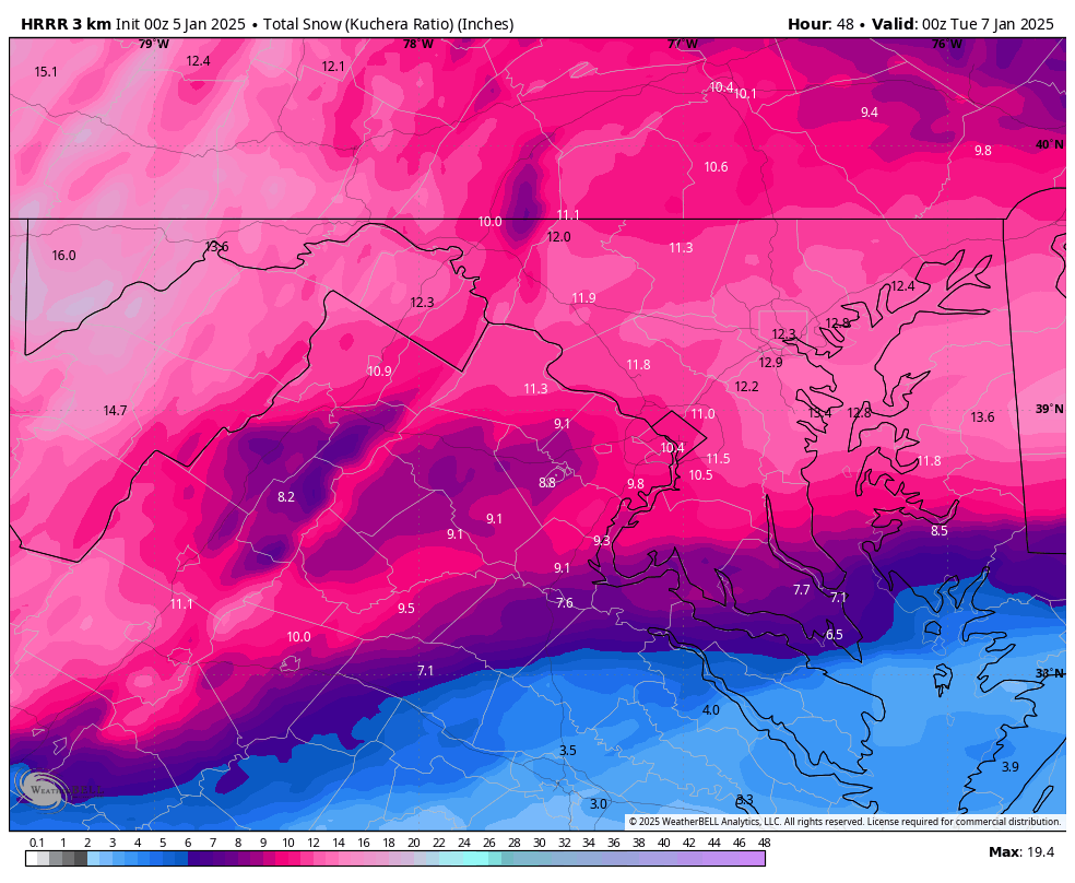
HRRR totals are going to be gaudy for DC
-
 1
1
-
 1
1
-
-
New HRRR has 6 inches in dc by sunrise.
-
1
-
-
Storm starting to look very juicy on the national radar. Also, it’s weird being at 19 degrees before a storm!!! Normally it’s 51 and we’re waiting for a miraculous 20 degree drop to occur (which never happens). Flakes will not be wasted with this one.
-
3
-
 2
2
-
-
1 minute ago, frd said:
Too warm East of the Fall line
Really? Was just going by the ensemble member low positions. Looks like a big cluster in spots that usually work for us.
-
1
-
-
6Z gefs looks fantastic for this too.
-
4 minutes ago, Weather Will said:
WB 0Z EPS looks great for this weekend!!!

Was just about to post that EPS looks like a clean miller A.
-
3k is basically a foot for all of us.
-
2
-
-
3 minutes ago, nj2va said:
Sick

1-3 on top of our 10-13

-
1
-
-
Solid 8-12 inches before the dry slot, see if we can get some backend stuff.
-
Just now, Prestige Worldwide said:
They are about as useful as a poopy flavored lollipop. No idea why anyone would care or base an argument for more snow based on them
The SREF + long range HRRR + 12k nam trio is basically useless
-
1
-
1
-
-
The SREFs are junk, surprised they are being posted so much.
-
1
-
-
1 minute ago, mitchnick said:
At 36hrs, you can see comparing 6z and 12z to this run how height lines jumped north from the 12z run.

This is a good trend for us. North enough to bring the goods but not north enough for dry slot/mid level warming.
-
4
-
-
4 minutes ago, jayyy said:
Reasonable to give a range given some of the uncertainties we face. Seems like they considered our local climo and a blend of models for that call.Yeah that looks like a really good map.
LOL HRRR is a beat down. 10 inches by afternoon and looks like part 2 forming.
-
3
-
-
I still think this bumps north tonight and tomorrow at least a little. Baltimore gonna do ok.
-
RIC gonna get nuked… enjoy
-
2
-
 1
1
-
-
5 minutes ago, nj2va said:
UK is going to be a big hit for Central VA, especially south of EZF. Over a foot for many places.
Crazy uncle UKIE is way south. 2-4 for dc.
-
Just now, nj2va said:
Just talking about the immediate DC area, but aside from the NAM handling the WAA different than every other model (including the 3k), we are consistently in the 6-10” swath on every model, including the UK the most southern solution. It seems we’re pretty locked into a 4-8” event, with possible upside depending on mixing and backside as coastal gets going.
Yeah the coastal is the thing I really want to trend better. Unfortunately as of now it looks like the globals (GFS/Euro/CMC) have that area of coastal snow just a little south of Dc Metro, would like to see that bump north.
-
1
-
.png.21a7eed725bdcd65d5e4851099b5a616.png)

January 5-6 Thing Storm Obs
in Mid Atlantic
Posted
New HRRR is 0.14 QPF with the coastal for my backyard. Even here in urban heat island hell we may be able to do 12:1 or 14:1 with that. Gonna be a beautiful 1-3 inches on top of the overrunning.