griteater
-
Posts
9,635 -
Joined
Content Type
Profiles
Blogs
Forums
American Weather
Media Demo
Store
Gallery
Everything posted by griteater
-
The JMA brought the low up into GA, then moved it ENE off the NC coast, so it's warmer and north - https://www.tropicaltidbits.com/analysis/models/?model=jma&region=namer&pkg=z500_mslp&runtime=2018120412&fh=0
-
Our low off California - https://www.tropicaltidbits.com/sat/satlooper.php?region=atlpac-wide&product=wv-mid
-
Yep prepare for the worst (or best!) there now and see where it goes
-
12z EPS Clown....similar largescale footprint as previous run, but higher totals (more consistency I would assume)
-
EPS Mean compare from 06z to 12z....at 500mb it had the same slight changes as the op run (good changes for upstate into central NC). It has the northern stream phasing in late a bit. Sfc low track is similar but a little closer to the coast off the Carolinas. Initially it was a little warmer thru Bama into TN and colder in the Carolinas (more damming), but it was a little warmer in eastern and central NC as the low went off the Carolina coast. This is a textbook look at 500mb for snow in upstate into central NC (and to the NW) when the wave is in central Texas in this kind of setup
-
Thank you, yeah burrel mentioned it....the last few runs of the Euro (and EPS) have been increasing the strength of a shortwave that drops into the Great Lakes just ahead of our storm wave....we want that to be fairly strong and drop in so that the heights along the east coast don't have a chance to lift north. I would assume the better shortwave trends thru the Great Lakes is stemming from increased ridging in W Canada, but I haven't looked
-
Oh yeah, I think it makes sense to have less confidence with what happens in the northern stream from Canada into the Great Lakes and the Northeast than we do with the southern wave. The damming high is a feather in the cap even if the source region is less than ideal
-
IMO, the biggest thing to watch for the upstate to central NC crowd is how firmly the confluence pattern holds and is reinforced over the Northeast prior to the storms arrival. I think we'll pretty much be able to count on the wave trekking west to east and holding its strength
-
Boone / Ashe look great right now, certainly better than yesterday. You have plenty of wiggle room with temps up there. Given the strong southern wave moving slowly scenario, this has the potential to be right up there with some of the big ones...but see the 48hr rule in my signature below...models will continue to change
-
3-4 inch liquid in W NC into the upstate....El Nino at its best
-
Final
-
Regardless of track, yes, if it Miller A's like this, models basically always underestimate the precip on the NW side
-
The northern stream wave does dive in late for a big phase...it's UKMet / Euro combo...tantalizing
-
And it's still snowing after this...let me go see if I still have a job now
-
It will sound weenie-ish, but the stronger the southern wave, the slower it will likely track...and the models tend to underestimate a healthy wave like this
-
I do question some of the mid level warming back into west-central NC...the 850 low runs from central Bama to Myrtle Beach....that's a great track for Charlotte even...should see nice cooling aloft on the backside of the Miller A
-
135 0 deg 850 retreats west into west-central NC, sfc freezing down in the upstate though
-
Small closed contour at h5 over central TN at 132...Northern Stream dropping in a bit
-
129 - snow from upstate to CLT to Raleigh and NW

-
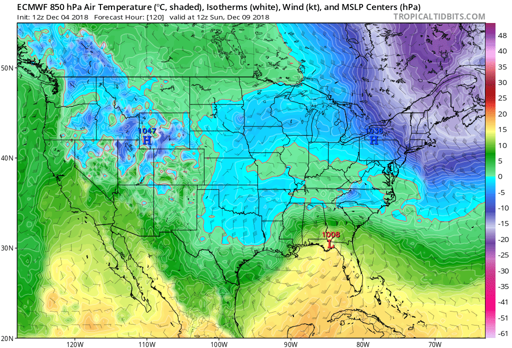
At 120, 850 0 deg says snow from Mack's house in the upstate over to Pinehurst and NW of there
-
Shortwave dropping down from the northern stream will likely phase in late like the UKMet
-
It's definitely a southern slider...let's see what it shows at the sfc
-
Closed contour right over the Red River OK/TX border at 105 at 500mb
-
Still all systems go at 93...it's a touch south of 00z so far
-
The shortwave running thru the great lakes at 81 is a touch stronger again...should help with the NE confluence to keep the system suppressed...all systems go so far