griteater
-
Posts
9,635 -
Joined
Content Type
Profiles
Blogs
Forums
American Weather
Media Demo
Store
Gallery
Everything posted by griteater
-
On your first question, stock La Nina forcing and 'unfavorable' MJO states both equal enhanced convection in the Maritime Continent (MC). This is a simple graphic (from Paul Roundy by the way) showing how MC convection typically leads to a -PNA pattern (not shown, but +EPO is common too). Here is the El Nino graphic As for 2010-2011, the MJO / tropical forcing doesn't run everything. The Greenland Block in December 2010 was absurd (there was one day in Dec that year where the AO was one of lowest values ever), and it just overpowered the -PNA look along the west coast
-
This has the +IOD maintaining
-
To completely shut down MJO phases though is a pretty tall task for any ENSO state. Feb '83 had MJO go thru 2-3-4-5-6-7. Feb '92 had MJO go thru 2-3-4
-
Regarding the MJO getting bogged down in the Maritime Continent, I have good confidence that's not going to happen in this upcoming circuit, and that's a good sign compared with what happened in Dec 2015. We'll have to see what happens going forward as there may be more resistance once the +IOD breaks down
-
Why is warmth in Nino 4 viewed as a bad thing? Scandi-Urals ridge with NE Siberia Low in December (Strat Warming). +PNA / -AO in Jan/Feb
-

Winter 2023-2024
griteater replied to Stormchaserchuck1's topic in Weather Forecasting and Discussion
My thoughts on the upcoming weather pattern (Dec15-Jan5) and whether it offers potential for winter weather in the Southeast and Southern Mid-Atlantic -
Global Wind Oscillation charts (AAM) from prior years are linked in the tables at this site: https://www.sierraphotography.com/wxnotes/ Here is the current chart vs. 1982-1983
-
If tropical forcing has no direct relation to our actual observable weather, why are you mentioning the MJO? The very definition of the MJO is a dipole consisting of an enhanced convective phase and a suppressed convective phase that propagates eastward thru the tropics.
-
He's so smart. I'm in awe. I'm just trying to figure out where the posts are in here that are calling for a cold Dec in the E U.S.
-
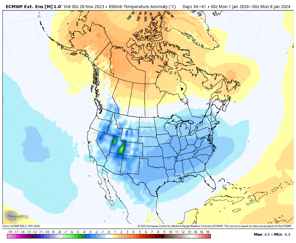
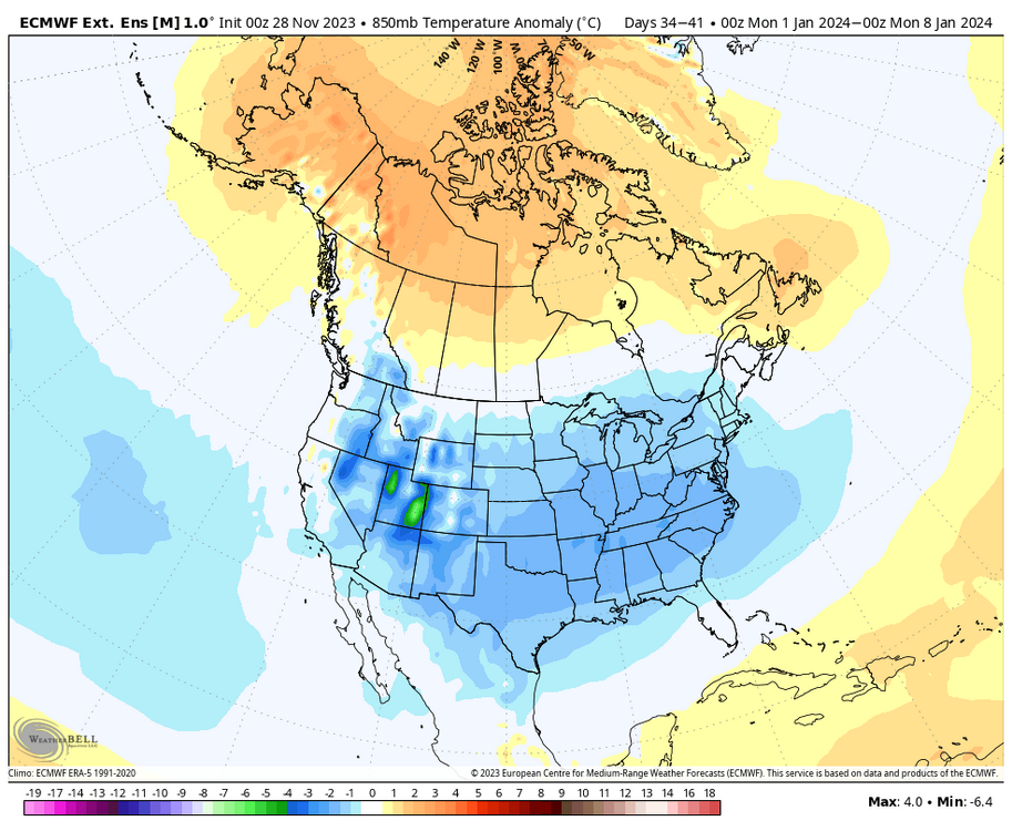
Jan 1 to Jan 8 850mb Temp Anomalies on Euro Wk
-
Euro Ext here Dec 4-9 has -VP from W IO to Dateline Dec 9-14 it's centered over the Dateline Dec 20-25 it's weakened some over the Dateline, but it's hanging there as part of the ongoing, west-based low frequency Nino signal this summer/fall. More -VP has moved east into Americas / Atl Ocean / Africa / W IO (MJO 8-1-2) It holds that look to the end at Jan 7-12 Could be some slight timing differences in the end, but IMO, the general idea is on point here
-
If the PDO is winning, we may see a central Pac ridge and east Pac / west coast trough. If east-based, super nino idea is winning, we may see a big east-based Aleutian Low. If west-based forcing, strong nino idea is winning, we may see a climo Aleutian Low with -EPO / +PNA. My chips are on the last one for Dec 20 - Jan 10, but we'll see. Should see an undercutting subtropical jet stream at times in all cases...and increased potential for high-latitude blocking.
-
Here is an MJO product that combines the standard MJO with the current 120-day signal (i.e. the background base tropical forcing pattern). This product has the MJO running thru 8-1-2 from Dec 15 to Jan 10. Euro Weeklies look similar. Source: https://ncics.org/portfolio/monitor/mjo/RMM/
-
From NOAA's weekly MJO update:
-
2.17 for Dec should do it if Nov is 2.01 (my estimate for Nov from post last week). 1.66 / 2.01 / 2.17 for OND = 1.95 avg, rounded to +2.0
-
I like a little later, like Dec 20 - Jan 10, but I hear ya
-
It's something to watch as we've seen slowdowns on the modeling in recent years when the MJO signal moves thru the Maritime Continent. In the end, I think it's just a blip and a bit of a slowdown is a preferred outcome in my mind as MJO 8-1-2 produces a more wintry pattern in the east in late Dec / early Jan than it does in early-mid Dec per the Roundy seasonal MJO composites. IMO, the GEFS Ext RMM plot below has a pretty good handle on how the MJO related -VP should roll east from the MC into the W Pac, then W Hemisphere thru 8-1-2 in late-Dec / early Jan. The Euro Ext and CFS have similar ideas. AAM should be on the rise mid-late Dec as well (El Nino like). I'm not clear on some comments made suggesting that El Nino forcing is maybe a bad thing, as quality El Nino forcing to me is +PNA with undercutting subtropical jet, with hopefully some high latitude blocking thrown in.
-
-VP (blue/purple) is a measurement of upper level divergence which helps with rising motion, which fosters anomalous convection / thunderstorms in the tropics (and yeah, that is sometimes referred to as forcing..as in, forcing for rising motion and convection). +VP (yellow/red) is the opposite, upper level convergence which leads to sinking motion / anomalous subsidence / less than normal convection. Those maps are averaged over 3 months (base pattern), but the MJO and other MJO like waves are running atop the base pattern at quicker timescales, and those can enhance or suppress the base pattern as they travel west to east in the tropics. The farther east and stronger -VP in the east-based ninos tends to place the nino climo Aleutian Low closer to the west coast, and make it stronger / more expansive (warmer across the CONUS)
-
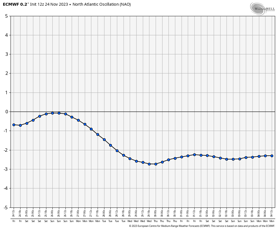
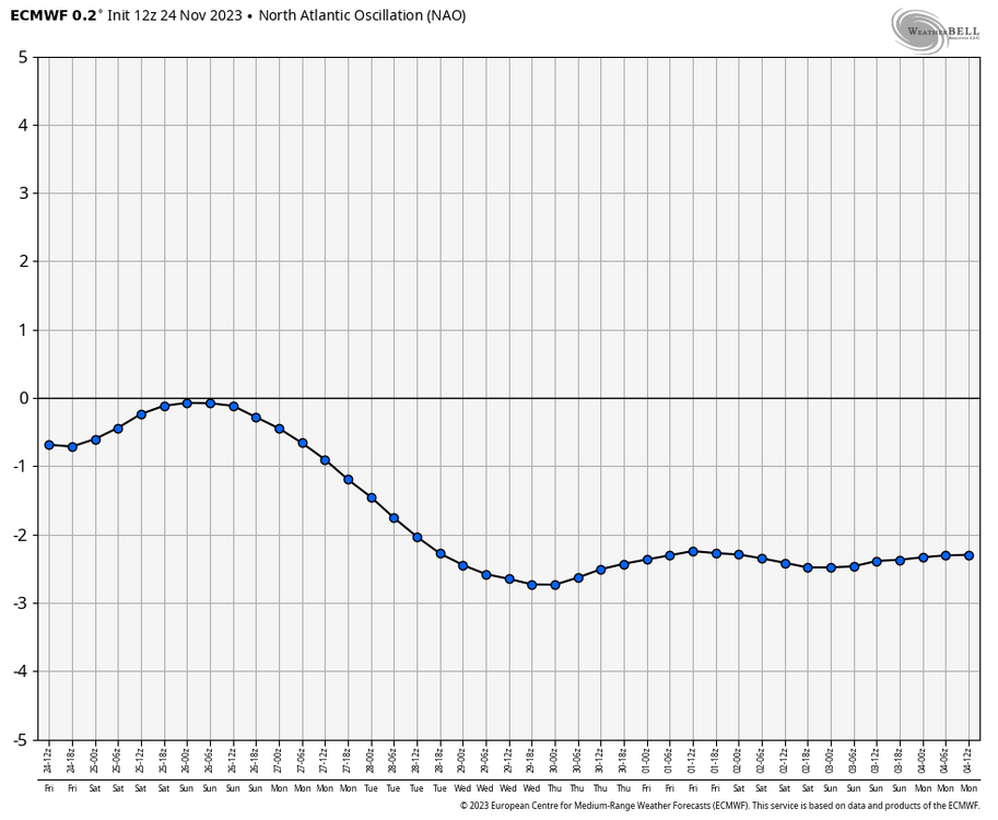
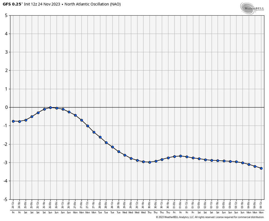
I called for AO and NAO to be positive in Dec as well (forecast from 11/8), and negative averaged for Jan-Mar
-
Solid -NAO is 4-5 days out on Euro and GFS. Ensembles are the same
-
Had this in my winter outlook which covers it in a nutshell...
-
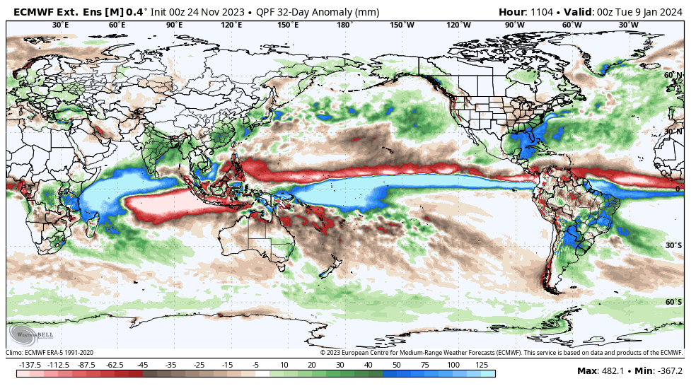
Euro Weeklies 32-day precipitation anomaly for Dec 8 to Jan 9…the Dateline bulge lives on
-
If you loop thru those GEFS VP images, the VP just rolls steady west to east thru the full loop. So it’s essentially acting like we are in ENSO neutral. In general, you would expect it to slow down and spend a bit more time in the typical El Niño zones as it treks thru given the ENSO state, but the tropical forcing has been a bit on the fast side all fall so not sure what to make of it
-
If Nino 3.4 for November comes in at 2.01 (my estimate from yesterday), that would make SON +1.76 (1.60, 1.66, 2.01 = Avg of 1.76). And in order for OND to be +2.0, Dec would have to be 2.17 (1.66, 2.01, 2.17 = Avg of 1.95, rounded to +2.0) My guess is that Nino 3.4 will level off next week in the 2.1 range, then drop down to 1.9 or so in early Dec post WWB, then in late Dec climb back up to 2.1-2.3. Rough estimate of course, but my guess is that we see another good westerly wind burst in mid-late December (maybe not as strong as this month's though)
-
Jan Null's designation requires 3 tri-monthlies for ENSO strength designation. On his page, you can see where he designates 2009-2010 as a Moderate El Nino with the max tri-monthly peaks of 1.6 / 1.5 / 1.3 - https://ggweather.com/enso/oni.htm I like the logic in Jan's method as you want to see the strength designation sustain itself a bit just in the same way that the 0.5 threshold must be sustained in order to designate it as an El Nino in the first place (0.5 must be sustained for 5 tri-monthlies for El Niño designation, as you know) And I've mentioned this method many months ago, so not the first time posting it. Regardless, we have a very strong Nino that is a bit weaker than the strongest on record from an ONI standpoint