

The Waterboy
-
Posts
989 -
Joined
-
Last visited
Content Type
Profiles
Blogs
Forums
American Weather
Media Demo
Store
Gallery
Posts posted by The Waterboy
-
-
7 minutes ago, Weatherdemon said:
From Norman NWS...
The snow associated with the main storm system will move into the
area Sunday morning near or just before sunrise Sunday morning.
In general, the model QPF is a little lower than previous
forecasts, so have adjusted the snow amounts down just a touch. We
are still expecting amounts of 5 inches or more throughout the
forecast area, with the highest amounts of roughly 8 to 9 inches
across southwest Oklahoma and area of north Texas near Wichita
Falls. The storm system looks a little quicker and have adjusted
the timing of the forecast and heaviest snowfall a little bit.
Their comments about the heaviest amounts in SW OK don’t match the 18z GFS at all. It’s actually the exact opposite. Lowest amounts were in that area.
-
 3
3
-
-
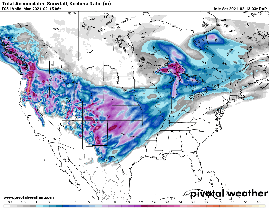
Interesting that the GFS Kuchera ratios continue to be in the 15-18:1 range for storm 2.
-
3 minutes ago, NwWhiteOut said:
Call me silly but I dont have a good feeling regarding this first storm for NW Arkansas here at all by what Im seeing and reading idk. We are so border between 1-3" and 6-8". They are being conservative and smart regarding storm 2 and mentioning it could be even more significant depending on its track, who the heck knows lol. Still flurrying here off and on everytime a cloud rolls by.
I think we’re going to be good. 4+ inches looks pretty solid. Especially if one of the bands shifts SE just a few miles. The RAP has it just trying to get into Benton Co.
-
2
-
-
V16 continues to drop heavier amounts compared to the main run.
-
18z RDPS stayed pretty steady to 12z. Continues to slide the heavier bands just a tick SE especially if you compare the 06, 12, and 18z.
18z below...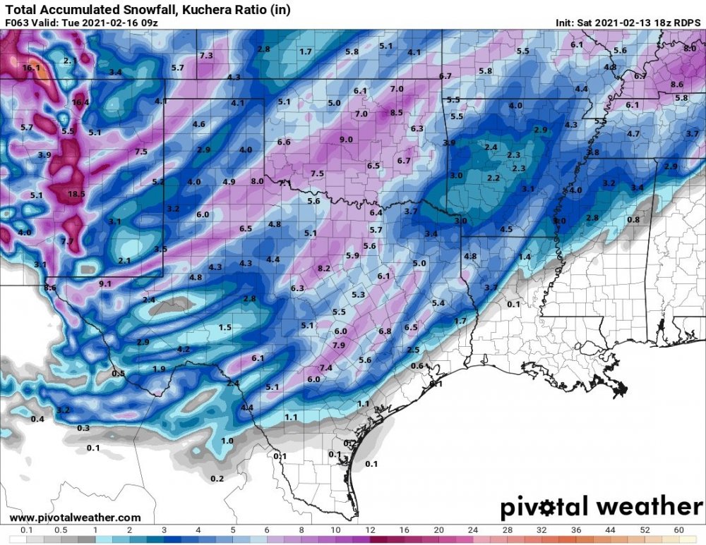
-
2
-
-
Just now, Weatherdemon said:
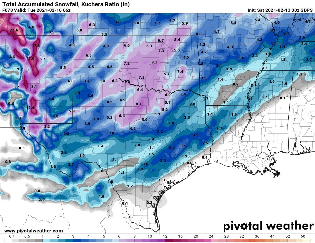
NAM3K throws down 16 in OKC
Anyone have the WeatherBell 3km map? I want to compare it to Pivotal.
-
-
^That’s an I-44 hammer! Awesome to see the models increasing again. Definitely been sampled by now so hopefully all future runs continue this way. Suck on that, Lucy!!!
-
1
-
 1
1
-
-
Euro looks similar to the NAM which isn’t a great look. Takes the heaviest precip way south. Big hit for Central/Eastern AR.
I guess the first wave is solid for OK. NWA is in a bit of a snow hole similar to the NAM. Still drops decent totals area wide.
-
1
-
-
One more. 03z RAP. Again, not too shabby.

-
2
-
-
Canadian is OK. 0.25 to 0.50 QPF’s.

-
1 minute ago, stormdragonwx said:
Those were with the PC but I've done it with my Android its just a bit trickier to accomplish. You have to tap and hold the white area at the top of the graphic to get the "save image" option with mine.
Got it!!!! User error on my part. I was holding the picture not the white area.
-
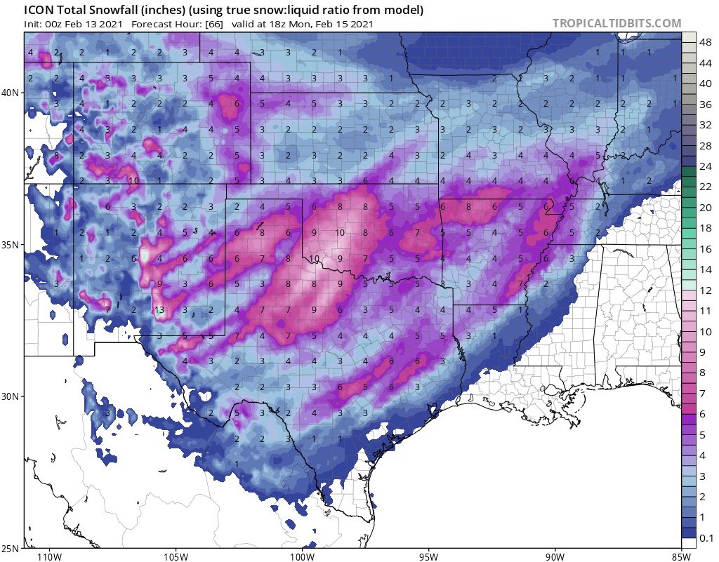
00z Icon through storm 1.
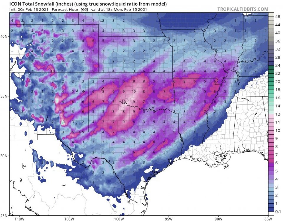
Both storms ^
-
4 minutes ago, stormdragonwx said:
You're welcome. lol
Thanks! Are you copying those on a laptop or your phone? -
V16 looks way better again. Can’t post the map for some reason. QPF slightly higher than “regular” GFS run. The few locations I spot checked have about 0.1 QPF more on the V16. Is the NWS moving to the new version very soon? Personally I would prefer to use that regardless of what it’s showing.
-
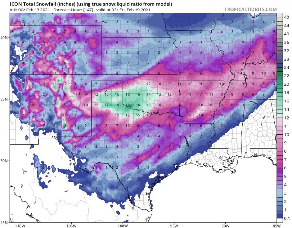
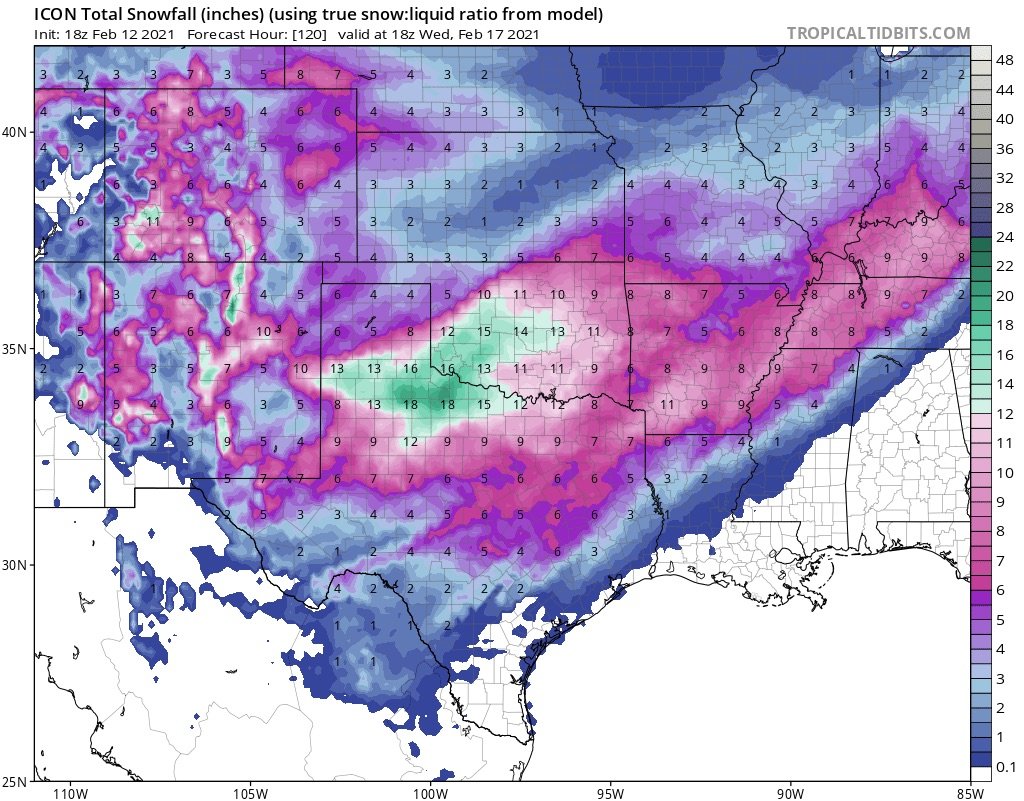
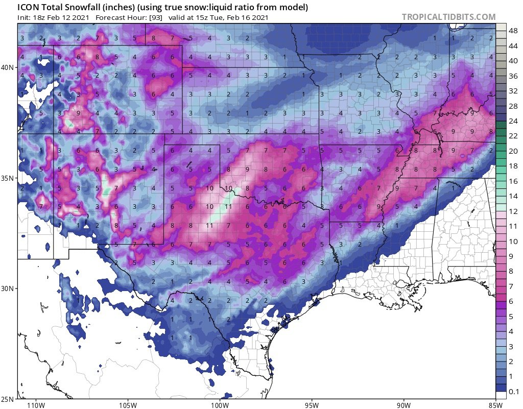
I8z Icon out to 120 with both storms.

-
18z ICON through storm 1. Not sure if this is 10:1 ratios or Kuchera.

-
2 minutes ago, MUWX said:
You are setting yourself up to be taught a very important lesson. Big storms no longer happen here.
I wasn’t suggesting this will happen. Just pointing out that the models haven’t tanked completely.
-
21z RAP goes out to 51 and looks solid. And is almost identical to the GFS at hr54.
https://www.pivotalweather.com/model.php?m=rap&p=snku_acc&rh=2021021221&fh=51&r=conus&dpdt=&mc=
-
Guys (and gals),
We still are in play for 6-12+ for almost everybody in 2 storms. Yes, lots of room for error. We aren’t getting shutout though.
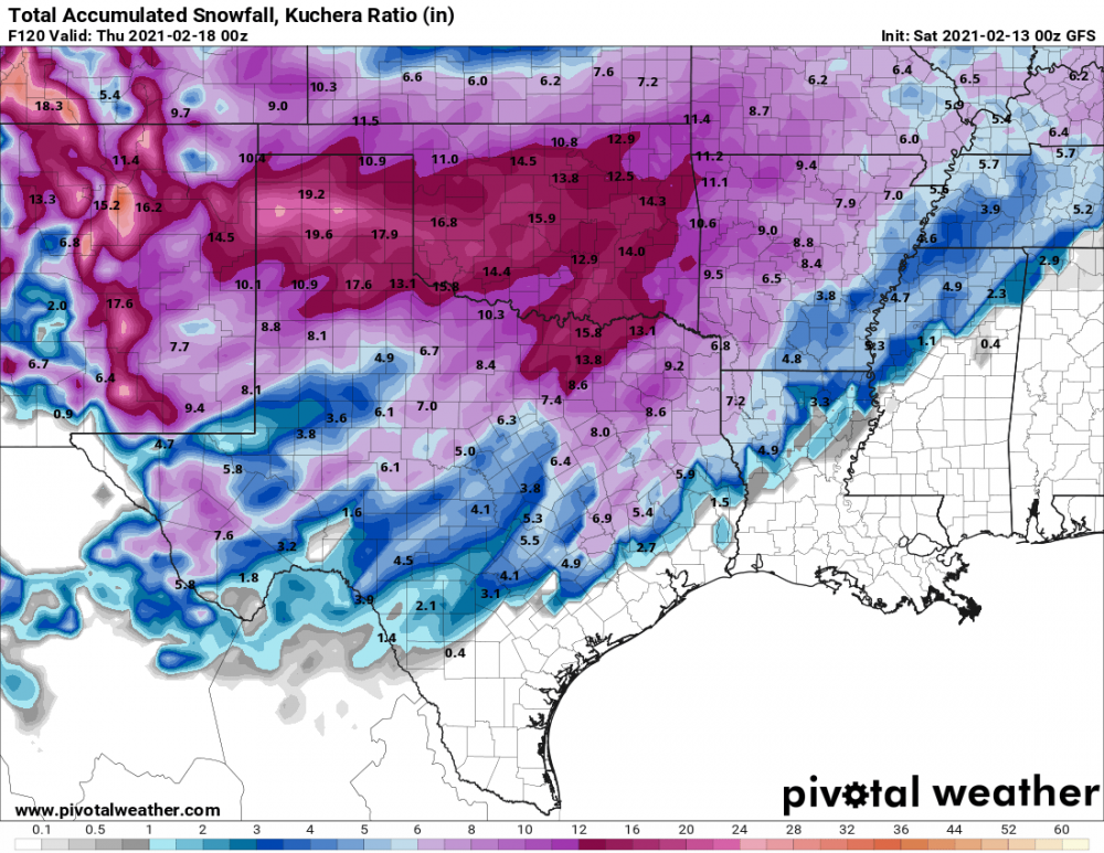
Here’s some reassurance from the v16...-
2
-
-
V16 held steady minus the hole over NWA.
-
We haven’t really discussed the typically NW shift that often occurs 24-48 hours out. We’re right in that timeframe now. I know you KC folks want to see that! Thoughts anyone?
Like many of you, I’m nervous since we’ve been watching this for days (but it feels like weeks!) and the models had huge totals that are now trickling downward some. The chances of this being a swing and a miss are extremely low.
The GFS has been steady. The Euro looked solid. Canadian moved our direction. No need to panic (I’m talking to myself) on one run of the NAM that still wasn’t a total train wreck.
If things hold steady we’ll be getting excited by this time tomorrow. Now, where is my brown paper bag before I hyperventilate!
-
1
-
5
-
-
3 minutes ago, JoMo said:
18z NAM is really going to wrap it up at the end of the run.
We need that a little more NW and we’re golden!
is the break in the action between he 60-66ish odd? And feasible? It is the NAM after hour 60 so grain of salt.
-
1 minute ago, Solution Man said:
Post it
For some reason I can screenshot from Pivotal on my phone. Not sure if it doesn’t allow it or it’s user error. Here’s the link though.
https://www.pivotalweather.com/model.php?m=hrrr&p=snku_acc&rh=2021021218&fh=48&r=us_sc&dpdt=&mc=


MO/KS/AR/OK 2020-2021 "Winter" Discussion
in Central/Western States
Posted
Thanks! Does the 18z keep the 2nd storm way south or did it come north closer to the GFS?