

The Waterboy
-
Posts
989 -
Joined
-
Last visited
Content Type
Profiles
Blogs
Forums
American Weather
Media Demo
Store
Gallery
Posts posted by The Waterboy
-
-
JoMo will like the 12z NAM!!!
-
 1
1
-
-
Tulsa’s write-up overnight seems to favor the RAP which looks pretty good for most of us. 09z was a good run but surface temps still going to be iffy.
They also mention the two things we hate to hear: warm nose and dry slot. -
For what it’s worth the 18z HRRR looks pretty good for SW MO, and NW AR. Not so good further west.
-
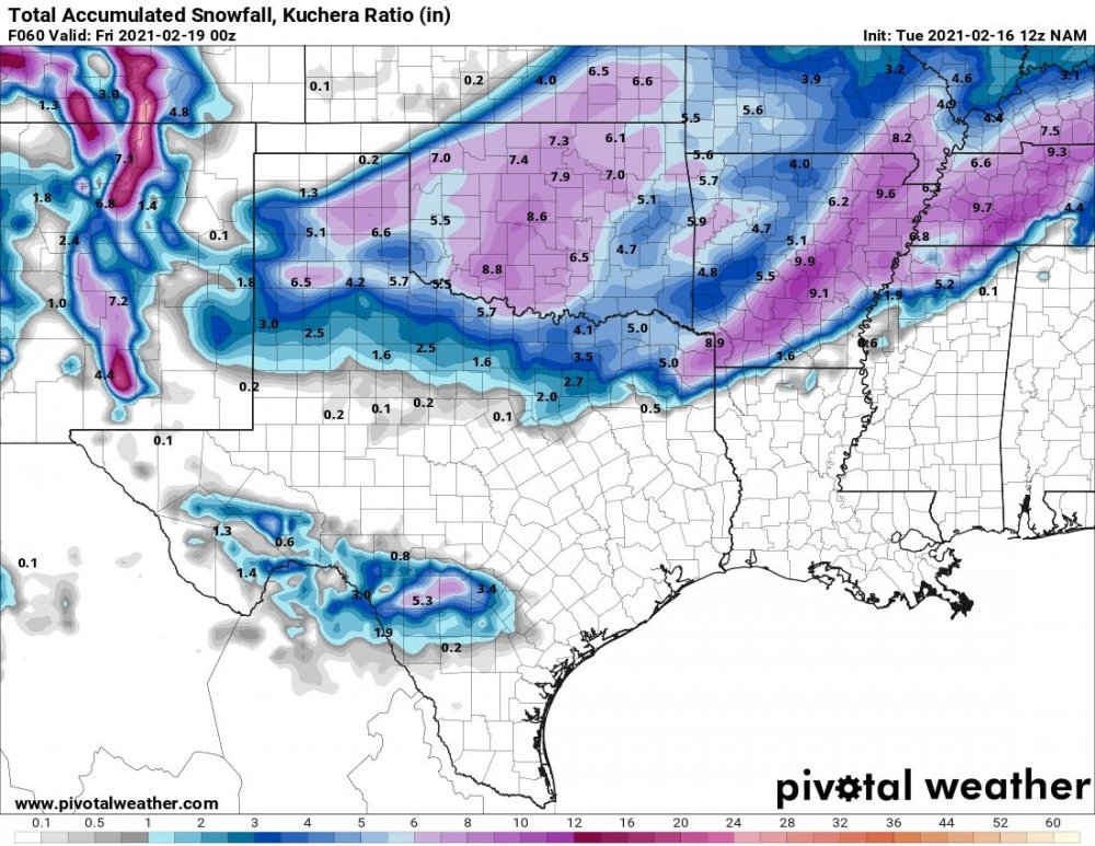
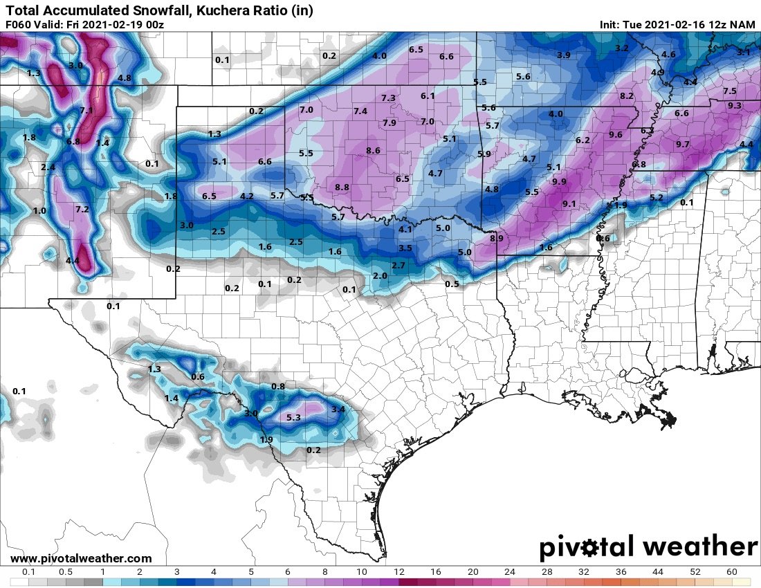
12z NAM looks solid. Huge improvement over the past two runs.
-
1
-
-
15 minutes ago, Holston_River_Rambler said:
now here's a real
weenie post, looks like the SREF members like em some gulf lows, lol:

I count 16 gulf lows or gulf coastal lows and 8 inland ones.
Holston,
What is the link to this site? I’d like to see this earlier in the run for my area in AR. Thanks!
-
I hate this hobby.
-
1
-
-
The ICON wasn’t horrible.
-
StormChazer,
Do you have 18z Euro details? I saw hour 90 in another forum but it was already in Central Ark at that hour. Curious to see what 84 and before looks like.
-
1
-
-
5 minutes ago, JoMo said:
18z GFS is looking faster with the system. Going to result in the heaviest being over NE AR and SE MO.
Let’s hope that trend doesn’t continue. We’re threading the needle as it is right now. Any shift East like this is bad news for most of us.
-
6 minutes ago, JoMo said:
12z Canadian finally coming in, a bit farther NW and more QPF.
Looks to me like the 2m temps at h84 are 3-4 degrees colder on the NAM/GFS vs the Canadian. Doesn’t matter by h90 as everyone is below freezing at that point.
Not sure if that is a concern yet but NWA has 6-12 hours of precip above freezing (on the Canadian) before the changeover.-
1
-
-
Tulsa just got NAM’d…
-
23 minutes ago, JoMo said:
Very strange system for this area, digging south down the Plains across western Kansas.
I was thinking about that earlier too. We don’t see too many dig south from Montana/North Dakota.
Do you recall anything similar that actually panned out for us? I actually kind of like these clippers. They are typically faster moving with limited moisture but we can squeak out a couple of inches. This one seems to have more potential than usual.
-
53 minutes ago, MUWX said:
Springfield is starting to buy in on the threat it appears, prepare for it to start trending in the wrong direction now.
Tulsa NWS as well
-
12z GFS solid for some of us. Still need a little more shift west for the Tulsa folks.
-
2 hours ago, JoMo said:
So the 06z GFS happened, wow. Probably not going to happen, but wow.
That was very interesting! Maybe we have something to watch.
-
Definitely frustrating to see a majority of the models have snow in Colorado/ Western KS for it to disappear as it approaches us and pop again into TN.
The NAM is currently the only one giving us much of a chance. Maybe we score a dusting to an inch with the cold temps/higher ratios. -
18z GFS still looks good for the new year. Need a bit of a shift NW but plenty of time to worry about that later.
-
2
-
-
On 12/9/2021 at 1:07 AM, JoMo said:
Nothing really exciting as far as winter weather goes for the area. Pretty horrible pattern for winter weather through mid-month it looks like. After around the 21st or so. The Aleutian ridge looks to move into more of a favorable -EPO position. That should result in a greater chance of colder air oozing SE down the northern Plains. So, things might get more interesting near Christmas into early Jan.
00z GFS was a nice look for the 21st. Maybe a step in the right direction.
-
10 years ago today was the Joplin tornado.
-
 1
1
-
-
14 minutes ago, MoWeatherguy said:
2" on elevated surfaces here in Bella Vista.
Same here.
-
1
-
-
Huge flakes in Bentonville for the last 2 hours. Absolutely nuts. Grass is completely covered. Measured 1 inch on an elevated plastic surface and that’s with a fair amount of melting. What a day.
-
1
-
-
That was a pretty amazing 7-10 day stretch. We won’t see that kind of prolonged cold again for a long time. Maybe not in our lifetime. Definitely one for the record books. It was nice for a change to not have to worry about borderline temps, warm air advection, warm ground temps, blah, blah, blah.
Once the cold locked in we just needed the storm and we got two. With the 9” I got in December that puts me somewhere around 15-17” for the season. Definitely an upgrade over the past 5 years. Congrats to everybody! Maybe we should root for La Niña more often!
Finally, I almost hate to ask the question but I will anyway. Was that the end of winter or do we see one last chance for more before mid-March?-
2
-
-
It’s way too quiet around here. Any reports from OKC? Looks like it’s just moving into Tulsa.
-
1
-
-
12z NAM still looks solid.
-
2
-
MO/KS/AR/OK 2021-2022 Winter Discussion
in Central/Western States
Posted
15z RAP was ugly for SW MO and NW AR. Never gets below freezing during precip. Tulsa scores big.
This could be the warm nose that Tulsa mentioned.