

The Waterboy
-
Posts
967 -
Joined
-
Last visited
Content Type
Profiles
Blogs
Forums
American Weather
Media Demo
Store
Gallery
Posts posted by The Waterboy
-
-
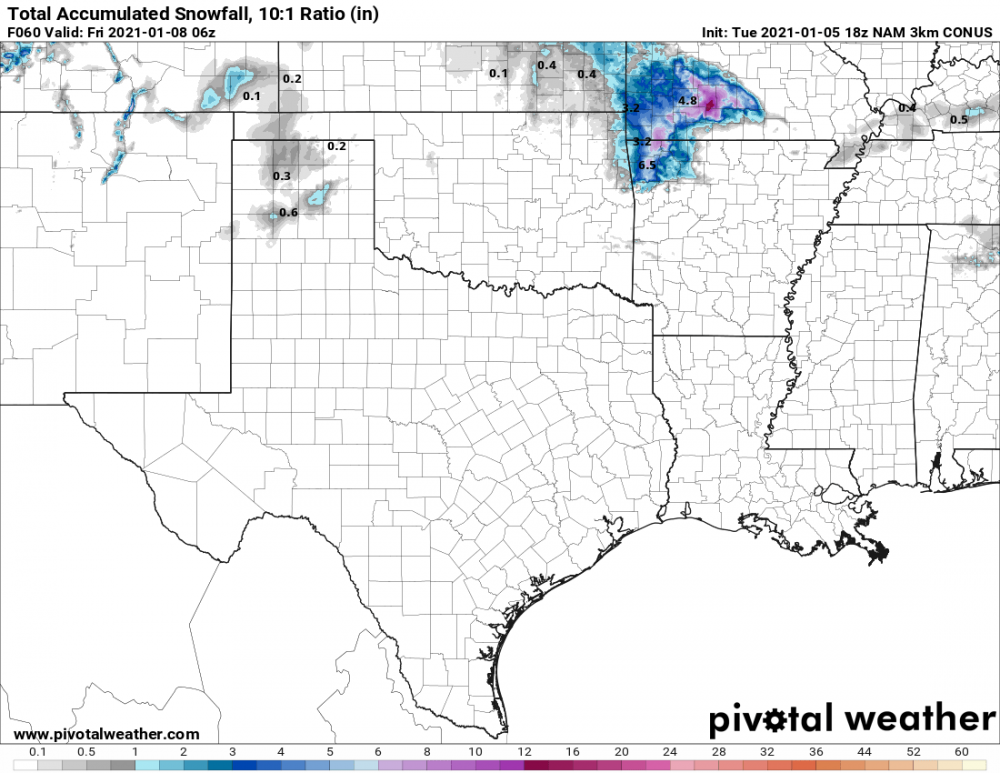
12z NAM, GFS, and RGEM increased totals over SW MO and NW AR. GFS-Para increased totals significantly.
Actual temp right now is about 3-4 degrees colder than what models (including hires) had forecasted.
-
32 minutes ago, stormdragonwx said:
Liking these trends for my area being less than 48 hours out.
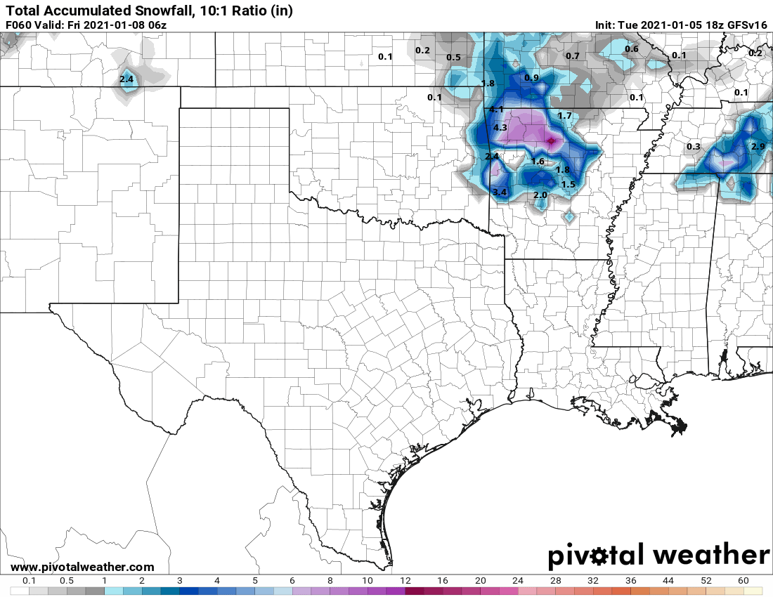
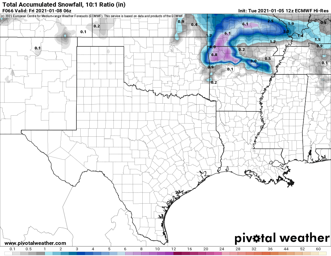
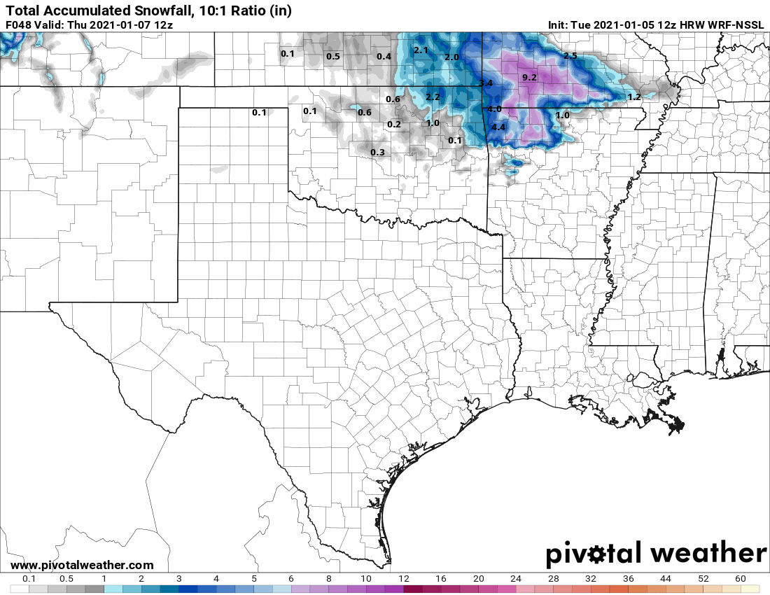
18z GFS (v16), 12z Euro, 12z WRF, and finally the 18z NAM 3km
Waiting for the 00z models to finish up their runs. I bet the WSW gets extended north and west a bit.


I agree! It’s looking good for those of us here in NW AR.
Not to be Debbie Downer but the 18 and 00z HRRR runs haven’t been great. The 12z was killer but it’s backed off since. Temps seem to be too warm.
-
25 minutes ago, JoMo said:
12z Euro is a bit farther west so SW MO, NW AR still looks like the sweet spot for rain/snow.
Looks like 2m temps are right on the border at 32-34. Are we threading a needle here? We should get some assistance from it being overnight hours. Not sure how wet bulbing would play into things either.
But the slight west trend looks good.
18z HRRR starts shortly...
-
12z HRRR just went nuts for SW MO and Northern AR. It even has snow as far south as Fort Smith.
-
I’ll take the 18z RGEM for the win please.
-
 1
1
-
-
I’ll take the trend on the 12z Euro being well south so the inevitable NW shift will put us in the strike zone! LOL
-
 1
1
-
-
51 minutes ago, JoMo said:
Well, that changed a bit on the GEM today. Interesting model flip-flops.
GFS-PARA 12z fairly similar to CMC. OK/AR get hammered.
-
Interesting details from ICT NWS this afternoon:
LONG TERM...(Tuesday through Sunday)
Issued at 252 PM CST Sun Jan 3 2021

* Wintry precip remains possible WED/THU
* Relatively low forecast confidence during this period

The focus during this period continues to be the mid-week system,
and what impact it will have locally. Ensemble guidance continue to
trend deeper and a bit further S/SW with a s/w that is forecast to
move out of the Rockies and potentially close off over/near the
Central/Southern Plains. Of note, this wave is still well out over
the Pacific Ocean (south of Alaska), so expect changes in the track
and intensity as the system draws near. Of note, ensemble QPF
amounts haven`t shown any significant trends in wetter vs drier.
However, ensemble spread among the various members has increased,
suggesting even less confidence at this juncture.

Given all of the above, I tried not to stray too far from the
previous forecast regarding temps/wind/precip. We`ll continue to
message the potential for some wintry precipitation with this
system, especially late Wednesday into Thursday, but this is far
from a certainty.

If you think the mid-week system carries some uncertainty, then look
no further than the end of the week. It appears a broad trough will
get carved out over the western half of the CONUS. Within this
trough, models show a bunch of shortwaves "dancing around" each
other, giving very low predictability. Perhaps what is most certain
is colder air being locked in place, but that`s about where the
certainty ends. If the cold air does, indeed, remain locked in
place, then any precip that develops late in the week could be of
the frozen/freezing variety.
-
14 minutes ago, stormdragonwx said:
Must be having some dry air aloft. Radar showing a lot of snow over me but it's not coming down anymore.

Same for me. It was some nice mood flakes regardless.
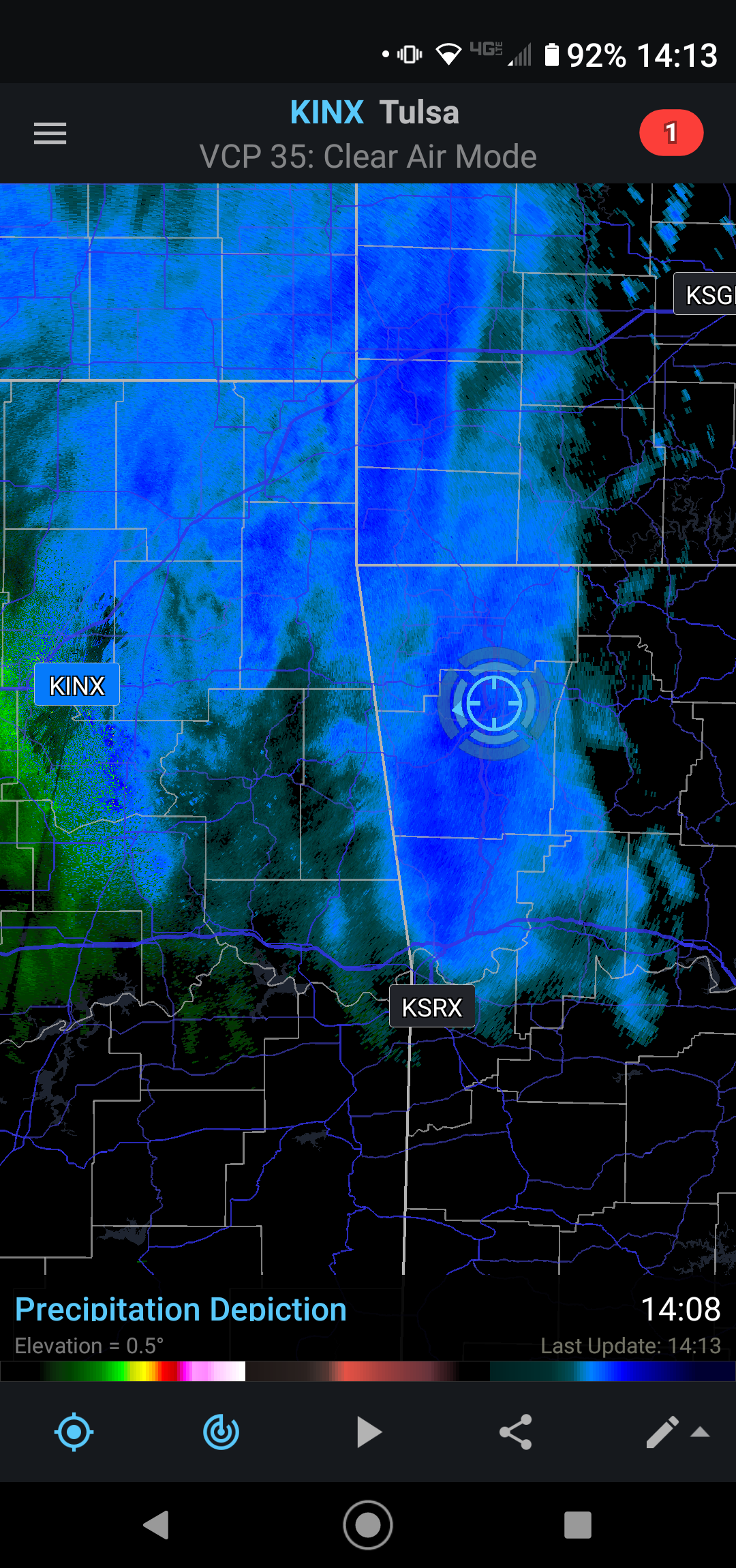
Also, is that the RadarScope app? I haven’t forked over $10 for it but thinking about it. Is it worth it? The Weather Channel and Accuweather app radars suck.
-
Decent snow shower in NW AR right now.
-
23 minutes ago, StormChazer said:
Stuck my fancy meat probe thermometer in my mailbox with the tip sticking out.
32 Degrees at my house.
This is hilarious. So many inappropriate jokes came to mind when I read that!!!! LOL.
-
1
-
1
-
-
The difference between the 00 HRRR and NAM are crazy. Significant SE shift on the HRRR. Hummmm...
-
27 minutes ago, OKTWISTER said:
That sounds like We really do not know what the system is going to do and tomorrow could be totally different....
Sounds about right. I agree with that interpretation.
-
30 minutes ago, rockchalk83 said:
Interesting note from NWS Norman regarding the 12z model initializations. FWIW, the 21z RAP edged west with the main precip shield, while the 18z Euro maintained.
The complicating factor with this forecast is that for precipitation
amounts and types with the cyclone, the models widely diverge in
solutions and the impacts that result from the solutions. In
discussions with WPC, the GFS/NAM 12z initialization had a 30 meter
initialization error in the 500mb height fields, which should have a
sharper upper-level trough. For this forecast more weight was put
towards the ECMWF solution for precipitation location and type,
however the forecast for precipitation type/impacts could
drastically change with any shifts in path of the cyclone.
Does “sharper upper level trough” mean further west? I’m not sure how to interpret that.
-
A 50 mile shift east or west and a couple of degrees up or down will have a big impact on a lot of us. Going to be fun to watch.
-
2 minutes ago, MoWeatherguy said:
Yes. Huge flakes here for awhile now.
Just started here too!
-
1
-
-
15 minutes ago, MoWeatherguy said:
Nice flakes now in Bella Vista.
Nothing in Bentonville yet but it’s very close if you’re getting some now.
-
I’ve held out hope until now but looks like it’s time to tap out for those of us in NW AR. Not happening this time. Hopefully you guys north and west cash in.
-
And quite a bit SE of the 12z run.
-
1 hour ago, rockchalk83 said:
I thought the same thing, too. When looking at the 500 mb vorticity, it really gets wrapped up and moves farther west as a result. I'm inclined to think it won't get *that* wrapped up and track farther west, but some of the ensemble members in all the suites are showing this, so it's a trend to watch.
Thanks for the reminder on looking at the 500 mb vort. I checked it out on all the models for comparison. It’s deep into Northern Mexico and crosses into TX just west of Brownsville. As we’ve stated, the CMC moves it a bit further east before starting the N/NE track. Lots of details to work out in the next 12+ hours especially as the shorter range models come into play.
-
1
-
-
I could be incorrect but the track of the surface low (especially on the 12z NAM) seems odd. It runs from Brownsville to Houston then due north from Dallas to Tulsa. Not saying it won’t happen that way but it isn’t typical from what I recall.
Our best track for snow is roughly Houston to Shreveport to Memphis. Doesn’t look promising. To Jomo’s point, if the west trend continues, frozen precip may end up west of OKC and Wichita.-
1
-
-
6 minutes ago, StormChazer said:
Considerable jump east, and the Euro has been following it recently.
FWIW Aaron Tuttle seems to think the Euro is too far west and will move east again. He also thinks there's good merit to what the HRRR was picking up on, on Wednesday.
That ICON run was very similar to the 12z Canadian as far as the track. We’ll see what Canada has for us shortly.
-
00z Hrrr is interesting. Snow and ice west of OKC breaking out by H35. Thoughts from anyone?
-
1
-
-
NAM, CMC, and RDPS continue to be further east with crippling ice. GFS and Euro further west and warmer. ICON is way west and can probably be ignored for now.

MO/KS/AR/OK 2020-2021 "Winter" Discussion
in Central/Western States
Posted
Well that’s an interesting change. A little further north and we’re all in business. Yesterday some of the model runs had it deep into the Gulf.