

The Waterboy
-
Posts
989 -
Joined
-
Last visited
Content Type
Profiles
Blogs
Forums
American Weather
Media Demo
Store
Gallery
Posts posted by The Waterboy
-
-
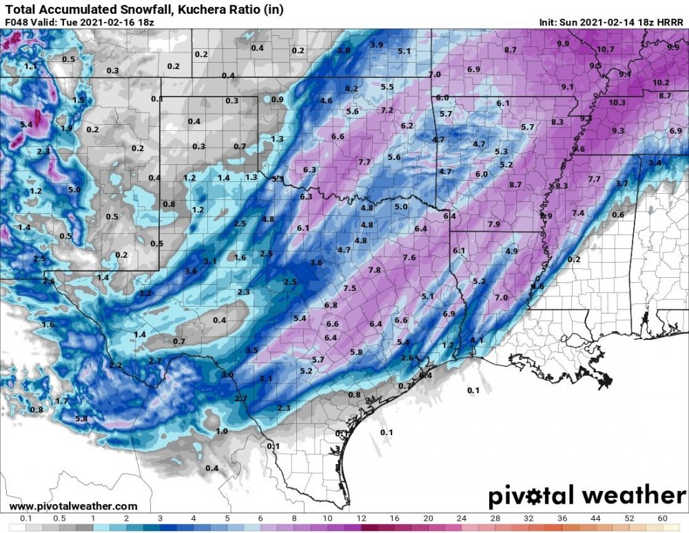
00z NAM caved to the GFS/Euro and shifted back south a bit. Still a nice storm. The first 34 hours look great then it falls apart up north after that. Big hit again south of Fort Smith into South Central AR.
-
2 minutes ago, garfan said:
Would the snow ratios be lower with the winter storm moving in on Tuesday?
According to the snow ratio maps on Pivotal they would still be between 15-20:1 depending on the location.
-
 1
1
-
-
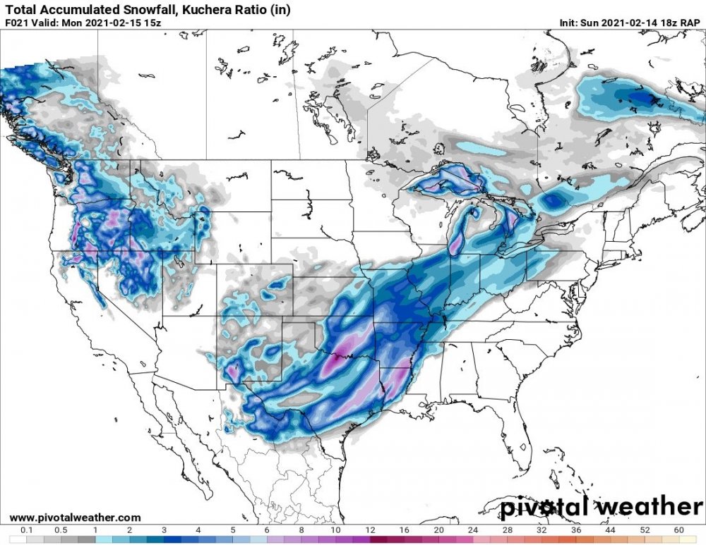
18z GFS and v16 not near as far north with precip as the NAM was.
For example, Wichita gets 7” on the NAM, 1” on the GFS.
Dodge City 8” on NAM and 0 on the GFS.
-
1
-
-
I remeasured in multiple spots. Somewhere between 5 and 6” here. So hard to say for sure. My previous 6 1/2” has to be too high although I find multiple areas with that. So who knows.
-
Just measured again. 6.5” in Bentonville. Definitely not an official measurement. But I found quite a few spots at that depth.
-
Little Rock 3am discussion mentions 20:1 ratios here.
Observed snow:liquid ratios by midnight have ranged from 10:1 to
nearly 20:1 across the central into NWRN AR...with a bit lower
ratios further south due to the added sleet.
-
5 minutes ago, NwWhiteOut said:
I know, it was coming down pretty good 20 minutes ago. That fireball in the sky is desperately trying to peek through! Man its cold out there goodness!!! What did you guys get up that way, any guesses?
5” measured about an hour ago. Maybe this last burst will push us to 6. We’ll see.
-
1
-
-
2 minutes ago, NwWhiteOut said:
Hard to say what we got here now, maybe I will declare it over again(being sarcastic lol) and we will all get another few inches! Seriously though, woke up and still lightly snowing. If I were to guess 5-6". This warning ends at noon then another watch is up for tuesday night onward for 4-10". Nice, bring it
Looks like we’re about to get a heavier band for the next hour or so.
-
1
-
-
Measure 5” In multiple spots of the year.
-
1
-
-
Awesome storm overall! Even if it didn’t drop huge amounts (8-12+) it was impressive for a few reasons:
1. Snow falling with it absolutely stupid cold. So much for the old saying, “It’s too cold to snow”.
2. Three different waves hit most of us.
3. As far as I can remember I’ve never been in a WS Warning while also having a WS Watch for another storm right behind it. This is VERY rare.
The only “negatives” I can think of are we didn’t get a foot and no blizzard warning. That 8 year drought will continue, but who cares.
Onto the next storm. As JoMo (or someone) mentioned yesterday the NAM and RAP seemed to handle this best. The HRRR not so much. We’ll see what round 2 (or is it round 4?) says.
-
3
-
-
1 minute ago, MoWeatherguy said:
Agree. We should cash in at least 3" or so.
Better late than never! Let’s get this going!!!
-
3
-
-
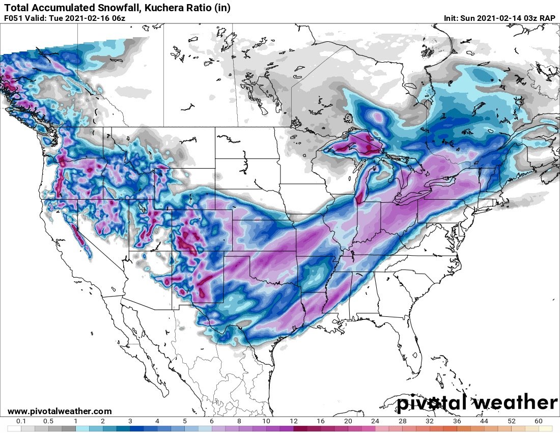
I know it’s jumping ahead but the 21z RAP has storm 2 further north. Looks good for most of us. Plenty of time to worry about that later but interesting to watch since the RAP has performed well so far.
-
1
-
-
In not loving the current look of the radar as it moves our way. As JoMo said, it’s narrowing and potentially weakening some. It’s going to be hard to see 4-6” more unless it wraps up and we see more on the very backside as well.
-
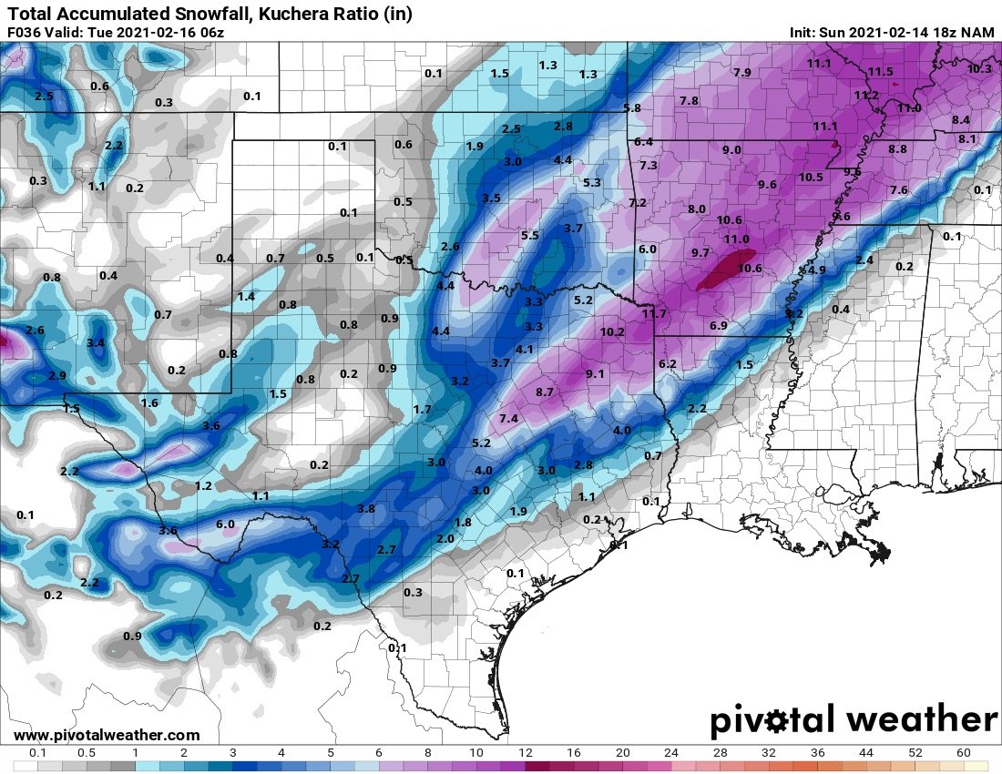
Using the Kuchera maps the 18z RAP, HRRR, and NAM all continue to show 3-8” additional through tomorrow.

-
Anyone have any live updates from the OKC area?
-
^ I suspect we’re all too focused waiting anxiously on round 2 today. But good to see those maps. Looks like storm 2 continues to track a bit more SE each run.
-
Last few HRRR runs hinting at wrapping the storm. Still snowing at 6 am tomorrow.
-
1
-
-
I really wasn’t expecting much out of this first wave. The HRRR runs last night had these bands further west. So I’m considering this first part some bonus snow. Around an inch here so far but hard to tell for sure.
-
1
-
-
2 hours ago, JoMo said:
So, about the 12z NAM... It's actually wrapping the system up. Probably just a NAM thing though.
Does the 12z GFS try to wrap it as well? Hard for me to tell.
-
6 minutes ago, NWAflizzard said:
Snow falling here being blown around by the wind. Smaller flakes with a few bigger ones mixed in. Sitting at 4 degrees. Now this is what I call winter!
This is a perfect day!!!! NWS Tulsa increased amounts for us NWA folks just a bit. 5-9” for Bentonville in the written forecast details.
-
1
-
-
1 minute ago, Weatherdemon said:
Norman NWS scaling down...q
Area Forecast Discussion
National Weather Service Norman OK
1059 PM CST Sat Feb 13 2021

...New AVIATION...

.SHORT TERM...
(This evening through Sunday)
Issued at 412 PM CST Sat Feb 13 2021

As discussed in the morning update, it looks like we will have
some low-level frontogenesis developing across south central and
southeast Oklahoma. The ageostrophic response to this
frontogenesis will likely enhance some lift north of this area
creating a band of snow. These are typically somewhat narrow bands
and difficult to forecast locations very precisely, but the best
signal is that this band will set up somewhere in central to
northeastern Oklahoma where it could produce a couple of inches
of snow between midnight and sunrise. The Winter Storm Warning
starts areawide at midnight, so that still covers this potential
early round of snow.

The snow associated with the main storm system will move into the
area Sunday morning near or just before sunrise Sunday morning.
In general, the model QPF is a little lower than previous
forecasts, so have adjusted the snow amounts down just a touch. We
are still expecting amounts of 5 inches or more throughout the
forecast area, with the highest amounts of roughly 8 to 9 inches
across southwest Oklahoma and area of north Texas near Wichita
Falls. The storm system looks a little quicker and have adjusted
the timing of the forecast and heaviest snowfall a little bit.
That update is from 4:12 this afternoon. All they updated at 10:59 was the aviation.
-
-
These radar returns in SW OK and Tulsa are very intriguing. That is at least 4-5 hours ahead of what the HRRR is showing.
-
3
-
-
^ That’s a good thing, correct? It also seems to be a tick SE again.


MO/KS/AR/OK 2020-2021 "Winter" Discussion
in Central/Western States
Posted
Caved might have been too strong of verbiage. I was just saying it ticked south some. Still a great look though.