

The Waterboy
-
Posts
989 -
Joined
-
Last visited
Content Type
Profiles
Blogs
Forums
American Weather
Media Demo
Store
Gallery
Posts posted by The Waterboy
-
-
I could be wrong but I question the GFS precip maps. We will have some warm air advection over the top but I find it hard to believe locations with surface temps in the mid teens to low 20’s have heavy sleet. I don’t recall ever seeing that before. The Euro/CMC colder, more snow solution seems to be more plausible. We shall see…
-
 1
1
-
-
18z Icon even colder than the 12z run. Heaviest QPF shifted a bit SE into Central/SE AR but snow line also pushed SE. Joplin with a foot at hr120 when the run ends. Tulsa between 7-10” and still snowing.
-
The last couple of runs of the Canadian push the cold air in much quicker.
12z yesterday at hour 132:Tulsa -37
Joplin - 33
Bentonville -38
12z run today at hour the same time (hour 108)
Tulsa - 26
Joplin - 23
Bentonville - 27
12z GFS today at 108 -
Tulsa - 20
Joplin- 21
Bentonville - 29
Also, For what it’s worth the 12z Icon is quicker with the cold air too with temps even colder than both the GFS and CMC.
-
7 minutes ago, StormChazer said:
All Good trends overnight with the three major players. Ice storm is definitely looming over the area. North Texas gets hammered as well.
Time to see what the afternoon runs show!
Do you have the 06 Euro?
-
12z ICON maps haven’t all loaded on TropicalTidbits yet but it looks like a HUGE amount of precip with temps in the teens and 20’s.
-
06z and 12z GFS runs both have brutal cold that rivals last year’s -15 here in NW AR. Temps behind the cold front drop rapidly as precip is moving in. I would think that would limit fz rain/sleet with a fairly quick transition to snow.
-
00z GFS shifted south some. More snow than ice for the most part. Still looks a bit wonky about hr 150 but nothing to worry about for now. The trend was good.
-
2
-
-
Just now, JoMo said:
18z GFS probably going to go pretty nuts.
Yes it did. Wow. Huge fz rain amounts in AR.
-
23 hours ago, JoMo said:
The timing of the system on the 24-25th is interesting on the GFS. There's a system opening up and lifting out of the SW as energy digs into the backside. If there's a phase, there would be a much larger storm.
EDIT: And the 12z Euro must have read my post........
Can you educate me (us) on what’s missing for the 24th storm? The wave digs deep into Baja and ejects east nicely but seems to be too open. Do we just need it to be more closed off, negative tilt, etc?
I also see the northern wave of energy that looks to phase as it moves into the northeast. Does that need to happen faster?
Thanks for teaching us, Yoda!
-
1
-
-
Heavier snow just missed us to the south. Fayetteville area getting moderate to heavy snow with roads already covered.
-
39 minutes ago, Wx 24/7 said:
Lock in the NAM please. Thanks.
Agreed! Benton County, AR gets hit solid. MoWeatherGuy and I will take it!!!
-
1
-
-
1 hour ago, Wx 24/7 said:
NAM and RGEM are a little further north and west with some snow late Wednesday, along with some freezing rain and sleet. Amounts are light... but something to track. The GFS and EURO don't develop this until further SE.
The last 3-4 runs of the GFS (including 12z) have the NW trend too. Still looks to be very light amounts but still something to watch. Sounds like the cold air behind the front on Thursday will be bigger story.
QPF on the GFS/RGEM is less than 1/10 inch. NAM is about 1/10.
-
Since there’s nothing much to talk about take a look at hr 84 of the 18z NAM. Significant snow moving into Western KS and the OK panhandle.
EDIT: No other models show this. CMC has a minor something. Other models are zilch.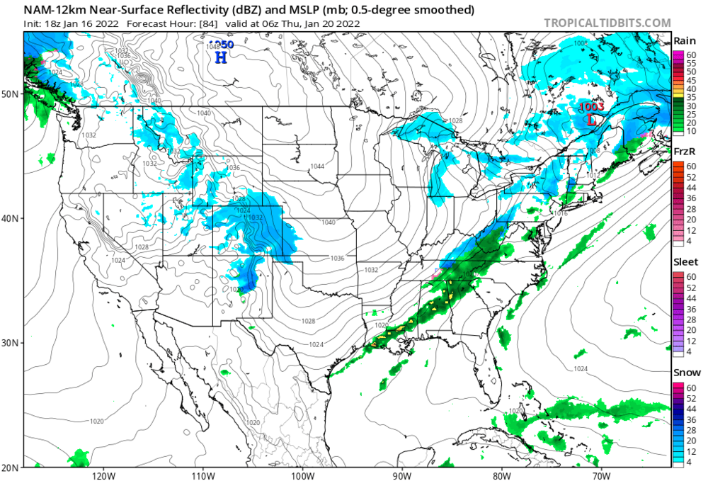
-
5 minutes ago, 1234snow said:
We’ve seen a lot of dry slots from winter storms in the valley before.
But I don’t recall the middle of a storm looking like the eye of a hurricane.I had the same thing happen yesterday in the far NW county of Arkansas. Snow was falling in every direction around me while I was in the donut hole for a good 2+ hours. Very maddening and unusual.
-
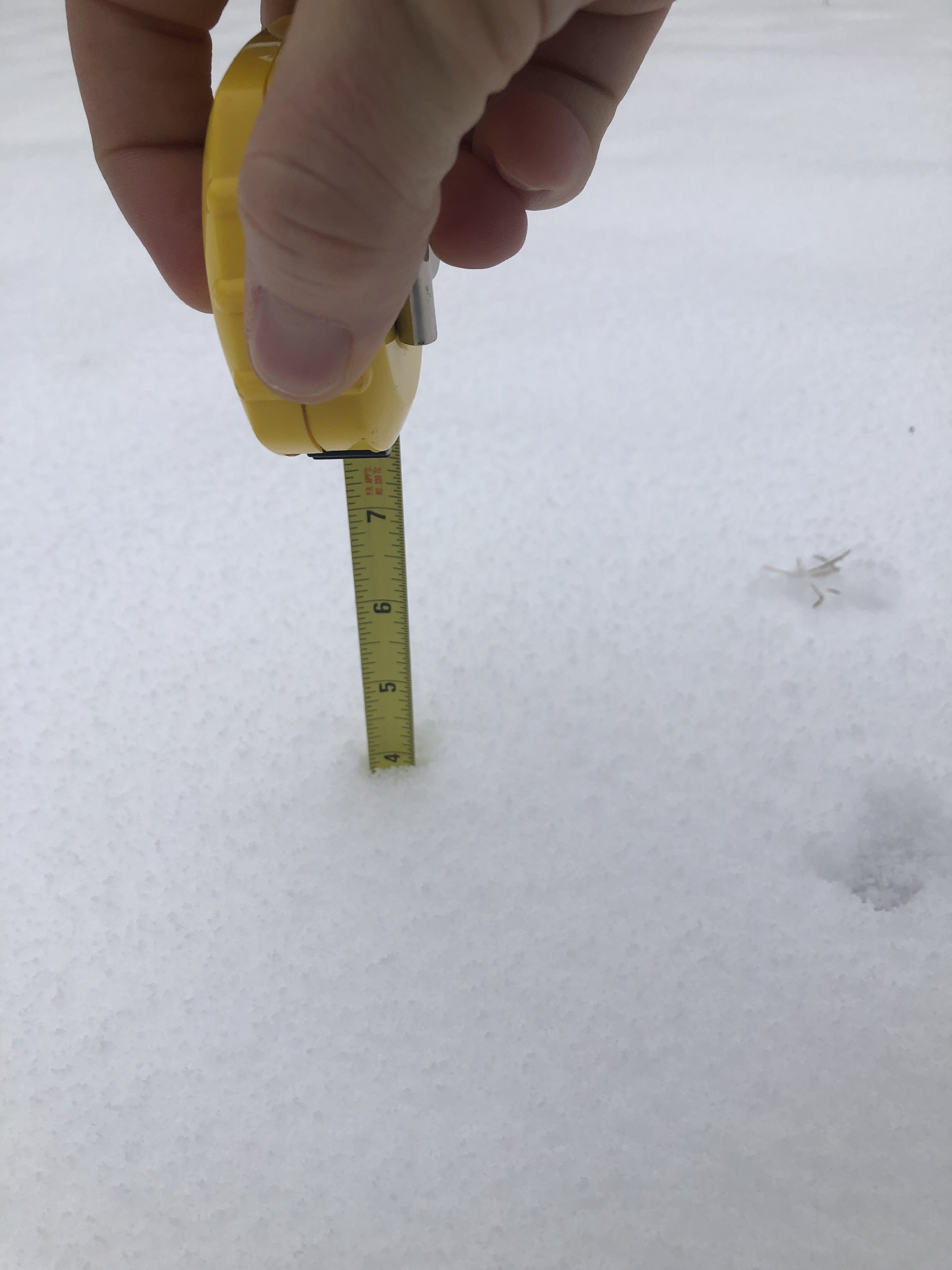
Full disclosure: I was a bit overzealous with my measuring abilities this morning. Blame it on lack of coffee or sleep deprivation. I was sticking the measuring tape too deep (insert “that’s what she said” joke here…) and therefore was wrong. Just re-measured around 2”. Maybe a slight bit of melting but still.
Just didn’t want to lose my slight bit of credibility with you fine folks!
Nice sized flakes coming down now.-
 1
1
-
-
Looks like a lot of us may get dry slotted quite a bit for a while.
-
In Bentonville I measured 15 different spots in the yard where it hasn’t drifted and show just shy of 4”. Sure doesn’t look like that much.

-
2
-
-
9 minutes ago, MoWeatherguy said:
Question on the Pivotal snow maps - how do you get the inches overlay to show on there?
Zoom in on the South Central US and then it shows. Doesn’t show on the continental US map.
-
2 minutes ago, MoWeatherguy said:
Waterboy, are you in Rogers/Bentonville?
Yes. In Bentonville about 5 minutes from the WMT Home Office.
Are you in Bella Vista? -
13 minutes ago, JoMo said:
N AR just getting hammered on the 00z HRRR.
That’s crazy! The 00z RAP looks almost identical at hour 21 (as far as it goes out) and it’s still snowing.
-
19z RAP looks good for most of us. It has shifted compared to the 15z run which is a good thing. Slightly lower total around Tulsa but looks more in line with GFS/NAM/CMC.
-
Has anyone noticed the current radar? It’s already showing light showers in SW MO around Springfield and quite a bit in Eastern KS. The HRRR doesn’t show any precip for the next 8-10 hours. Thoughts?
-
1
-
-
34 minutes ago, JoMo said:
lol at that 37 degrees and rain right over 3-4 counties in SW MO on the 18z HRRR. That little bubble of surface warm air sucks.
Meanwhile it drops 6-12 inches just south of you in NW AR. No way that could be accurate.
-
25 minutes ago, MoWeatherguy said:
The pivot and associated trowel is going to benefit someone greatly. And that will be on the backside so temps won't be a concern there.
03, 09, 15, 21z all run out to 51 hours. All other hours only to 21.
MO/KS/AR/OK 2021-2022 Winter Discussion
in Central/Western States
Posted
I guess I should educate myself on 850 temps then! LOL!