LakePaste25
-
Posts
1,020 -
Joined
-
Last visited
Content Type
Profiles
Blogs
Forums
American Weather
Media Demo
Store
Gallery
Everything posted by LakePaste25
-
I haven’t seen any +PNA Feb predictions on twitter, even from BAM. Seeing a ton of “look, it’s not a torch posts” which is weird because I also can’t find any reputable post that predicted a torch.
-
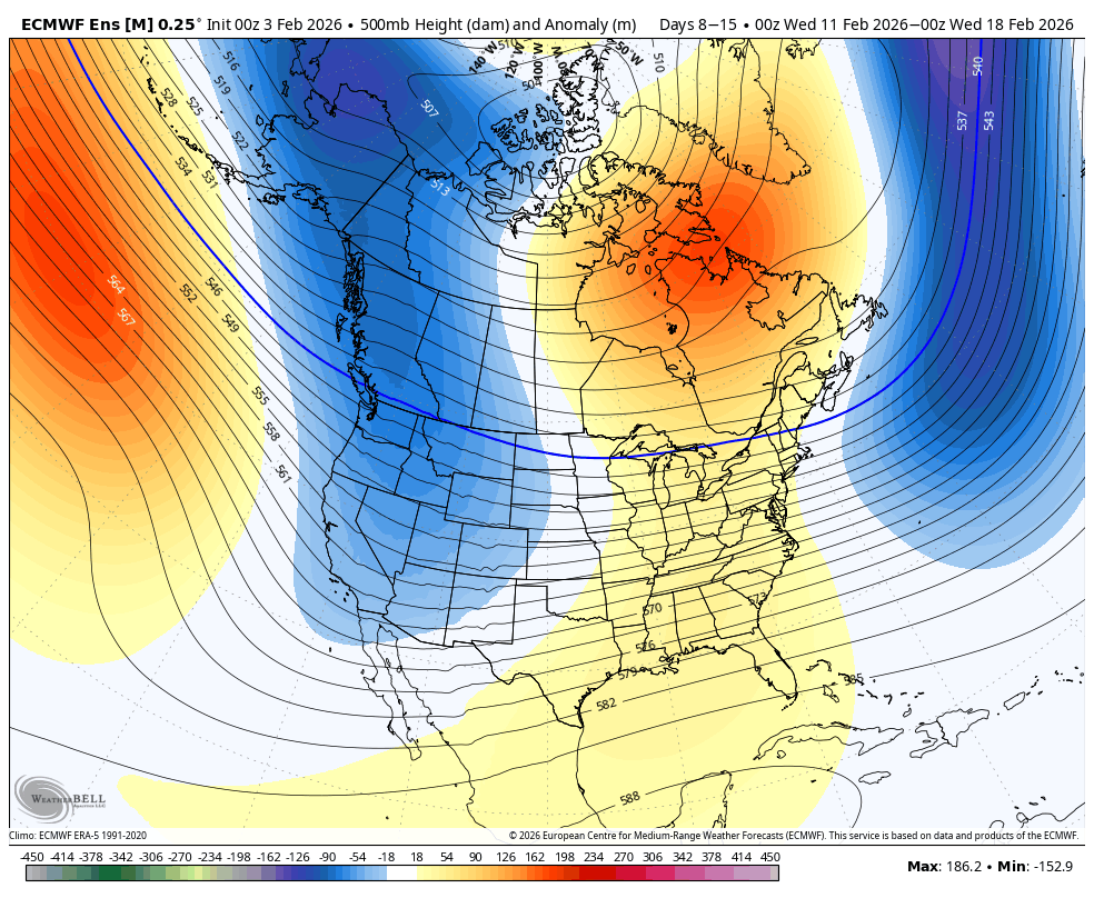
Feb Nina -PNA is serviceable here. Averages around 50% of normal (10”). Would say that weak-warm +ENSO Feb performs the best here, however. Such as in 2020, 2019, 2015, 2007.
-
Not a bad thing if we can keep the PNA aligned with the mountain west rather than west coast, and get some blocking. If it’s snowing at the space needle, then it’s probably more lights out.
-
Probably not in Feb, but I could see it happening sometime in March.
-
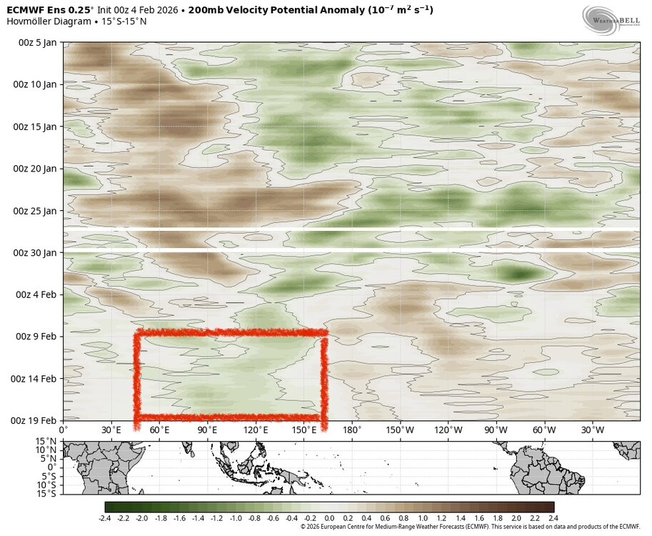
Need to get this area to move East for less of a -PNA IMO. Wavelengths are too short in Feb for convection to be hugging this area.
-
just need to get through that brief poleward jet extension which basically scours out the TPV from central and eastern canada, then we have a better cold air source for storms setting up across the Great Lakes later in the month as the aleutian ridge builds
-
Trough axis is simply not going to work even with the blocking outside of maybe NNE. Bring that trough further west, we can get systems dropping down from the NW. Or bring it east and we can get overrunning events W to E. But with this position, storms will cut.
-
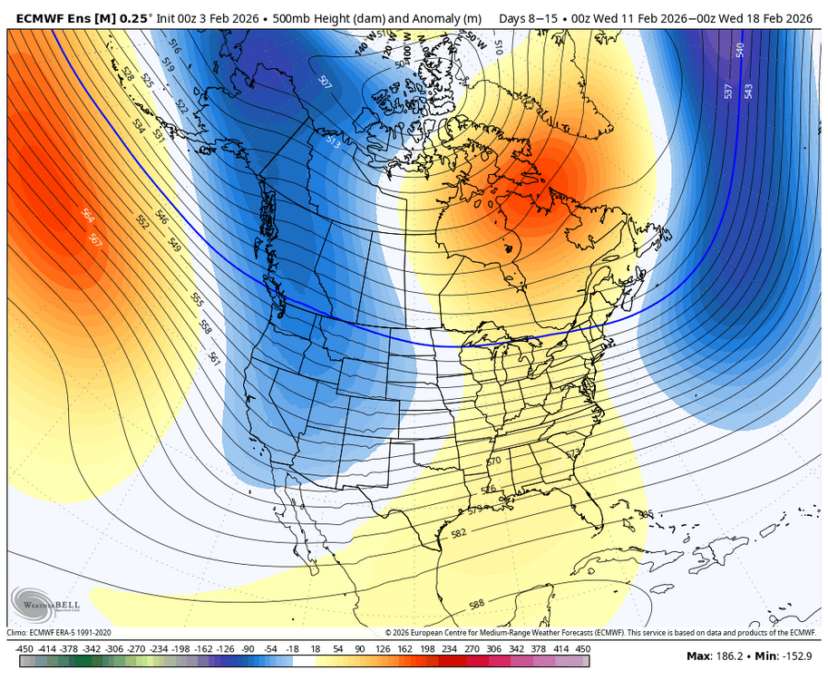
2/10-2/18 look fairly hostile for cold and snow in the northeast south of NNE unless we can see some improvements in the pacific as we get closer. The blocking will prevent a “torch.”
-
Disagree with this being the mean pattern. I think it’ll average out to a -PNA. That being said, it may not be an overwhelmingly negative PNA. -AO blocking to start out, and potential -EPO reloading the second half of the month should mitigate this. Not seeing a Feb 2018/2023/2024 style torch.
-
The deep cold and persistent snowpack has been nice, but I also wouldn’t mind getting back in on the action here on the I-90 great lakes corridor. We’ll see how it goes.
-
Yeah that’s why I’m thinking we still regress to a -PNA, but not as severe as 2023. The blocking will also help if it persists.
-
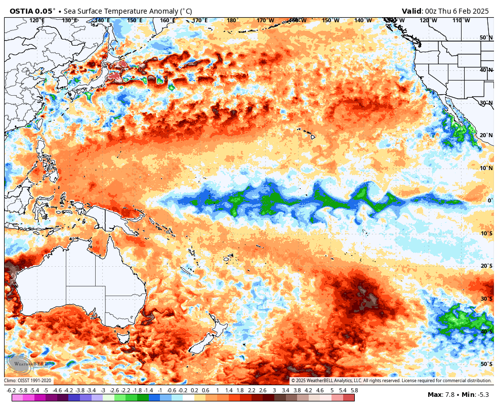
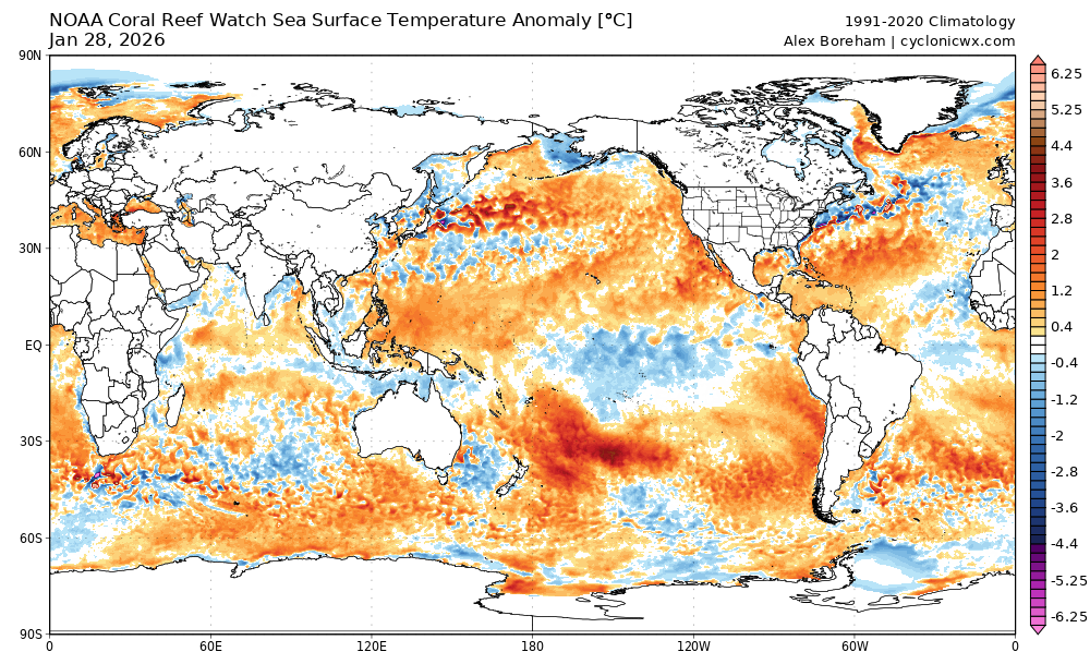
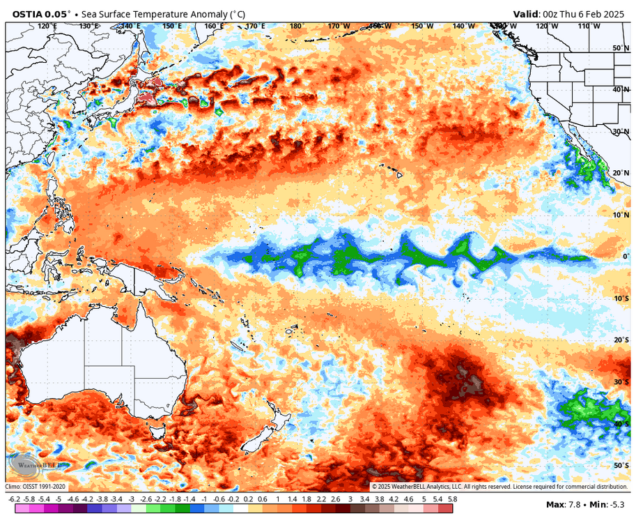
The Nina is still there. But this indo-pacific warm pool analysis is intriguing to me. Compared to this time in 2023, the warm pool is expanded much further east. Not quite Feb 2015 levels, but it’s close. If we do regress back to a -PNA, I could see the cold dumping into the mountain west or the high plains. I don’t think it’ll be as far west as 2023. If you factor in the blocking that keeps showing up, it might make things interesting.
-
The low temperature this morning at ERI dropped down to -7. This is the coldest temperature recorded since February 2015.
-
Erie is at around 50” on the season and the lake is about to freeze. Which means at the airport, we need another 50” to hit average and we’re relying purely on synoptic. That’s a very tough ask. 13-14 was above the 105” average and even last year was.
-
Likely real but it will potentially take longer for the Northeast to warm up due to the tendency of CAD. I’ve been burned too many times by this setup, so now I’m careful to say it’s an instant torch for us.
-
During 23-24, we did have Nino like jet extensions/CONUS torches. But, whenever the jet retracted, it snapped back to an Aleutian ridge Nina regime with cutters. There was maybe a 1-2 week period in Jan and another 1-2 week in Feb where we actually had an E US trough if i remember correctly. Usually we would see less aleutian ridging in a typical Nino.
-
This could take some time to make it to the northeast as we slowly scour out the cold air and also risk CAD setups. I’m eyeing early Feb for the warmup here.
-
models have been over-amping -epo’s most of the winter thus far, which happens to have downstream consequences of storms not phasing early and cutting. i would be careful to take the default position of “every trough will come east.” it’s important to understand the upstream model biases in play.
-
Makes sense. if you over-amp the -epo in the long range and then deamplify, the cold comes east rather than dig for gold in the west.
-
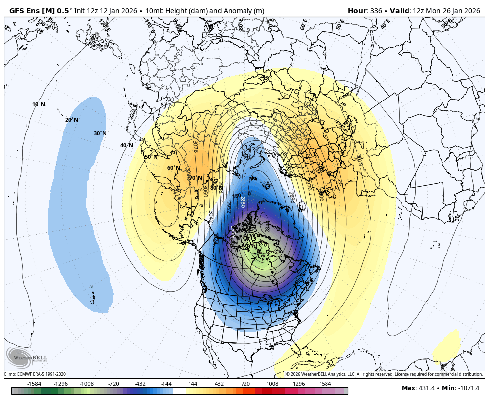
Looks like classic PV/+TNH coupling

-
Week 2 12z EPS guidance show more interest for the coastal cities. Not a strong signal, but it’s there. Week 1 should stay n/s dominant and confined to the lakes.
-
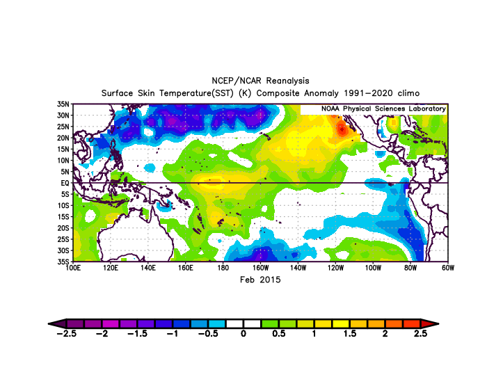
The 6z Euro has a clean, amped ridge out west and clippers digging for gold. I have not seen this pattern since Jan/Feb 2015.
-
Makes you wonder if we will ever see anything like 2014-2015 again due to that pesky MC forcing. Then again, February 2015 was generationally cold here and rivaled January 1977 in terms of anomalies (-15), so it would be tough to repeat that even without the warming.
-
it’s possible but we need to wait and see. 2014-2015 was headed that way until it fizzled out in the fall. Ultimately, we did go strong/super the following year (15-16). 23-24 was pretty much inevitable that it would be strong due to all of the warmth held up in the west pac after 3 nina’s.
-
I agree that pattern generally does not support sustained blocking. That said, I wouldn’t rule out an opportunity while that pattern settles in and while the blocking decays.