
Stx_Thunder
-
Posts
382 -
Joined
Content Type
Profiles
Blogs
Forums
American Weather
Media Demo
Store
Gallery
Everything posted by Stx_Thunder
-

Plains States Observations and Discussion Thread
Stx_Thunder replied to lookingnorth's topic in Central/Western States
Welp, looks like LOTS of people in the country are going to be *majorly dreaming of a White Christmas this year with this basically off-the-chart atmospheric warmth in store..
-
Texas 2025 Discussion/Observations
Stx_Thunder replied to Stx_Thunder's topic in Central/Western States
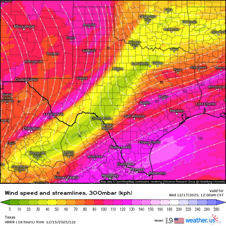
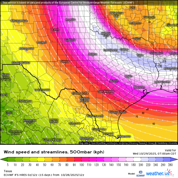
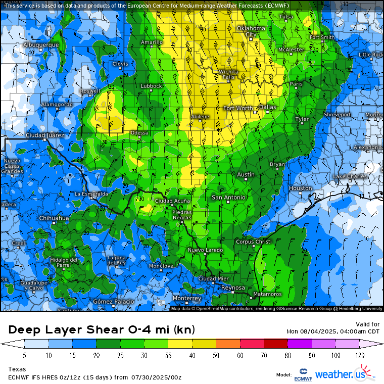
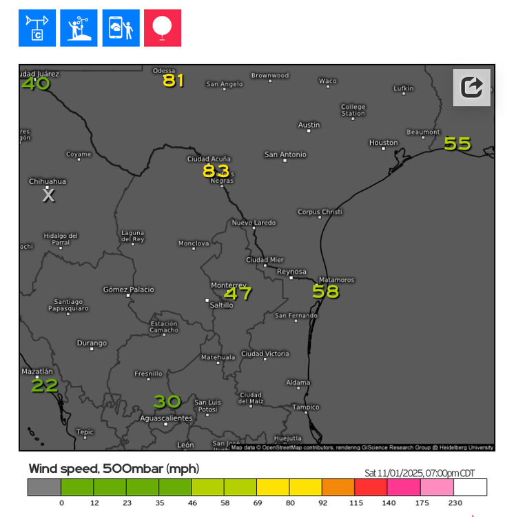
Hail threat (once again this ongoing cool season), looks to return to STX and coastal region tomorrow night (16th). Some severe hail is not out of question inland. Even if storms stay elevated. There was some embedded supercellular structures with hail cores in an MCC that actually separated into 2 opposite moving clusters not far off the coast last Friday night. The models (not too surprisingly) have been somewhat downplaying convective instability and moisture parameters lately around here. And the incoming mid-upper trough out west that SPC claims to be "weak" last night on D2 outlook has not appeared to be so on Euro since over a week ago. With even H5 flow still possibly going over 30 knots later tomorrow. 12z and 18z HRRR runs today now are also showing fairly stout 850mb southerly WAA flow potentially over 40 knots tomorrow as well. And even a split-jet flow regime moving over the state, tomorrow night (on Euro also). Which typically induces even more support for lift & dynamics aloft ahead of it.
-
Texas 2025 Discussion/Observations
Stx_Thunder replied to Stx_Thunder's topic in Central/Western States
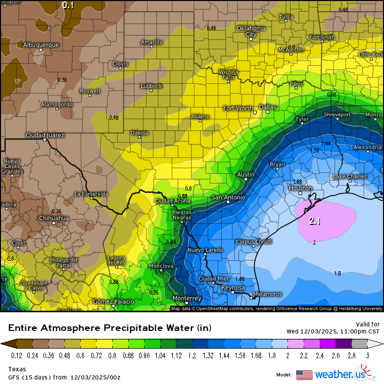
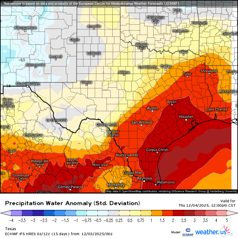
Euro & GFS have been consistent on this since last week, on 2+ in. precipitable water values (way above normal in December) near/over the coast. Starting late today ahead of the next SS trough out west and typical responding coastal Low pattern. Already above 1.5 in. PW on Brownsville UA 12z obs early this morning. I'll be danged if we still have this late spring/early fall type moisture depth around the coastal region later this month or beginning of 2026. Especially with a warming ENSO (into EN territory) trend now back in the cards.. CPC actually turned out to be right about the formidable ongoing phase 7/8 MJO "destructively" interfering with the typical warm/dry LN pattern, on their week 3-4 outlook discussion (in early November).
-
Texas 2025 Discussion/Observations
Stx_Thunder replied to Stx_Thunder's topic in Central/Western States
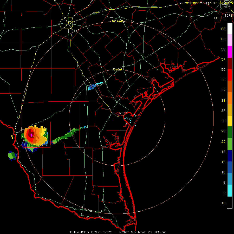
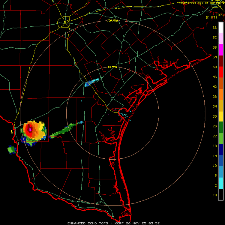
'Next to December now. And still got 3+ in. hailers (and likely over 80 DBZ reflectivity and 55 Kft storm tops), in the state tonight..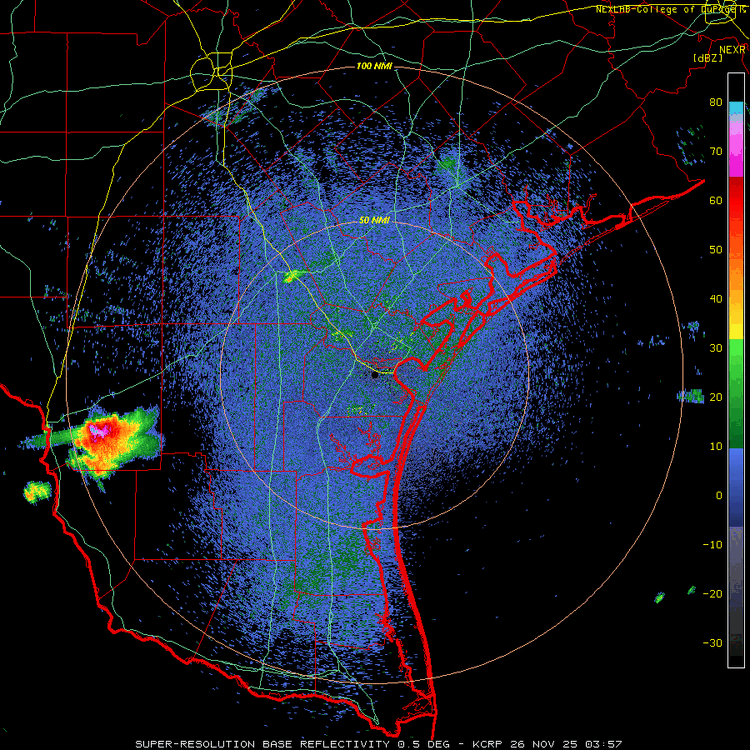
-
MO/KS/AR/OK 2025-2026 Winter Discussion
Stx_Thunder replied to stormdragonwx's topic in Central/Western States
Typical LN cool season pattern with more dominant subtropical ridging influence over the southern plains states. Hopefully, it'll back off some by Thanksgiving (more troughing coming back into the picture). -
Texas 2025 Discussion/Observations
Stx_Thunder replied to Stx_Thunder's topic in Central/Western States
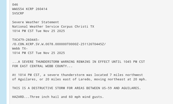
3 in. hailstones reported Saturday evening in the Coastal Bend area. Max size could've definitely been slightly larger given all the abnormally far south colder mid-level air & dynamics in place (for the time of year), near the region that evening.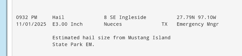
-
Texas 2025 Discussion/Observations
Stx_Thunder replied to Stx_Thunder's topic in Central/Western States
Even though will be a brief convective event with limited CAPE ahead of the next cold front on this upcoming first weekend of November, 'still looks pretty interesting over the Coastal region later Saturday afternoon - evening. There won't be a crazy intense ML jet over the state (that was observed earlier this week), but still looks to be another deep mid-level trough carving through The Lone Star. As DL shear is likely to be fairly strong. Up to 60+ knots in STX. Most interesting factor this time will be the steep ML lapse rates. More-so, because ML temps are going to be quite abnormally cold (having just entered the cool season). Even < 0 C, at H7! This cool season is already beginning to shape up to be a very interesting one..

-
Texas 2025 Discussion/Observations
Stx_Thunder replied to Stx_Thunder's topic in Central/Western States
It's been a while since I've ever seen mid-level jet core intensity this (crazy) high, so early in the new cool season. If this was during last Friday night's svr event, SPC would've likely talked about a moderate risk. 'Shall see how this strength trend influences the pattern over the state (and possible svr at times) during this cool season..

-
Texas 2025 Discussion/Observations
Stx_Thunder replied to Stx_Thunder's topic in Central/Western States
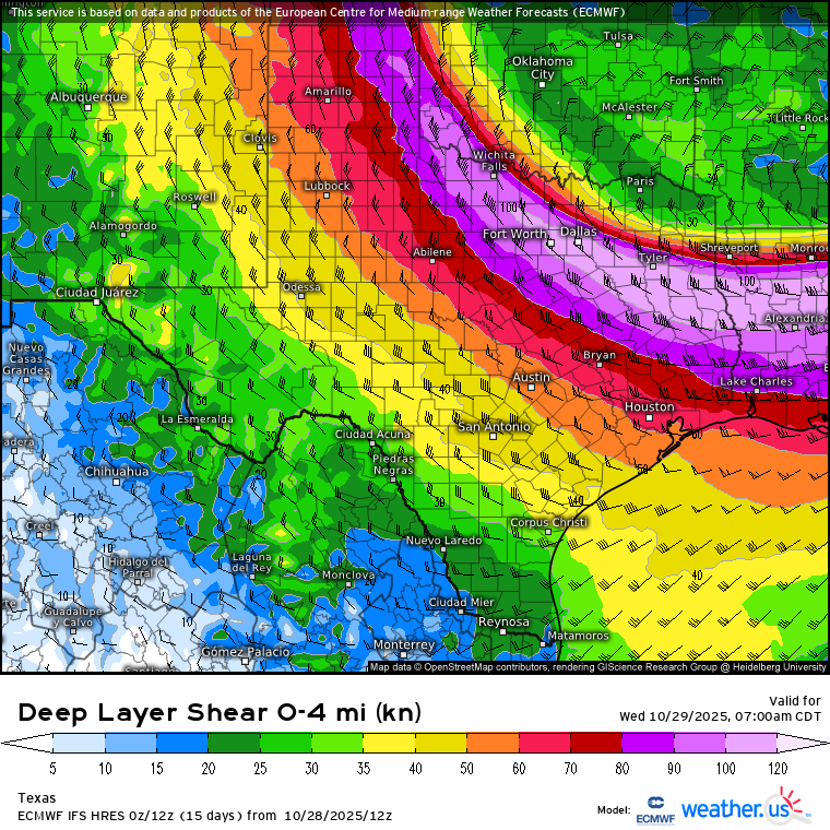
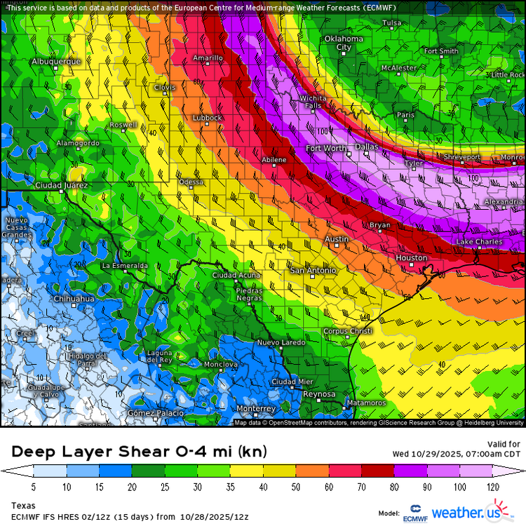
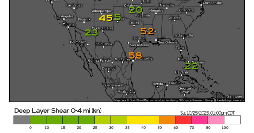
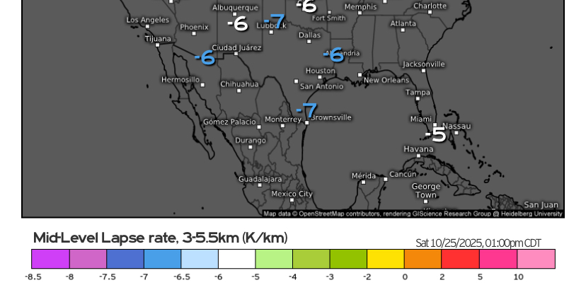
Decent severe coverage for the time of year from last night's MCS tracking across much of the state with decent rainfall totals also over the hill country and northern half. Hopefully the ground will soak up all the water especially in the basically 'been bone-dry all year SAT region as it could be a little while before the next sig statewide precip event from now. Severe not necessarily done yet over the southeastern half of state tonight as a new linear MCS is taking shape over the eastern part of CTX right now. DL shear observed near 60 knots (quite high for October standards), with ML lapse rates aoa 7 in STX this afternoon. And the M-UL circulation is currently tracking e/ne on satellite near DFW region. Got a robust storm cluster ongoing just off the lower coast as well.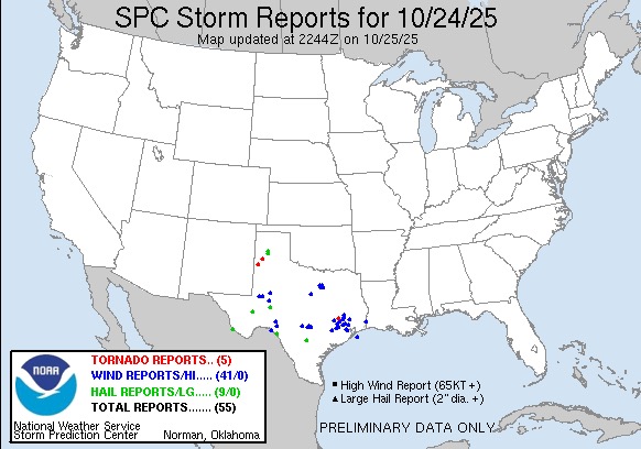
-
Texas 2025 Discussion/Observations
Stx_Thunder replied to Stx_Thunder's topic in Central/Western States
Looks pretty interesting this Friday - Saturday over much of the state with a fairly stout incoming Pacific Low/trough axis. Euro, GFS and ensembles had only really begun to latch onto a more deeper and more south-tracking system at the beginning of this week. So not 100% sold on it just yet. But the PNA has been (and still is) in a + phase. So this does bear some potential. Along with stronger storms and some kind of severe risk. Substantial rainfall amounts over a more drought-stricken TX now doesn't look very likely given its more likely progressive nature. But DL shear will at least be moderate. And this time, ML lapse rates will be steeper ahead of the system. Another big plus coming up is Fall looks to make an official statewide entrance next week before Halloween. The AO looks to go back into a negative phase while the AAO remains in a negative phase already. So below normal temps (even in STX) are not out of the question later next week. PNA is connected with the ENSO. Though as I've seen over the years, ENSO itself has an overall impact on TX. And, LN/cool phase ENSOs during winter have already been historically proven to be drier & warmer (on average). Due to more persistent subtropical ridging influence. The drought is likely going to worsen across the state at least for the first half of this winter. I would also not be surprised about record warmth (or even a few record-breaking, pre-frontal heat spikes in the southern half) at least in November and December. The fly in the ointment later this coming winter is the models are showing the ENSO (finally) heading back toward a warm phase or EN territory into 2026. If that's the case, then later winter - spring would more likely trend wetter & cooler overall with more SS jet influence over TX (instead of subtrop ridging). Which would also likely lead to a more active severe/MCS season in the upcoming spring. That pattern trend is what happened over the state more recently when EN started coming back in (early) 2015 and 2023. And to an extent, 2018 - 2019 - 2020 winter into spring. -
Texas 2025 Discussion/Observations
Stx_Thunder replied to Stx_Thunder's topic in Central/Western States
Before taste of Fall wx comes into STX at the end of this week, looks pretty interesting overnight into Thursday with the cool front crawling through the region. Already near 4 in. rainfall just in the past 2 hours right over the Choke Canyon reservoir under a very decent storm cluster looking at storm totals on CRP radar. In the region near SAT where the drought is still the worst in the entire state. PWs as usual this time of year down here pooling > 2 in. ahead of the front. But H5 flow is about 30 knots now, west-northwest on VWP. So starting to see better storm organization and more frequent lightning and even a few powerful +CGs (>100 Kiloamps) on lightning data across the region. Wouldn't rule out a few embedded transient supercells and several inches of rainfall spots overnight with decent mid-upper level support for September standards. Only severe caveat that's been a fairly common TX theme this year (even before summer) is once again, meager ML lapse rates. 'Though, Euro seems to be under-doing them a bit lately. -
Texas 2025 Discussion/Observations
Stx_Thunder replied to Stx_Thunder's topic in Central/Western States
TX Summer 2025 heat/humidity looks to come to an abnormally early halt after Labor Day weekend as fronts will start to surge through most, if not all the state (even into STX). Along with more statewide convective episodes, initially at least. Aside from temp evidence this week in the plains/midwest, signs of a very early season frontal passage in the state were already there since the start of August. Which had an abnormally deep north flow pattern aloft across the state that did reach 45 knots at H5, on DFW upper-air obs 0Z data August 5th. And the AO is trending back into negative phase to start September. Euro and even GFS and Canadian now are all starting to latch onto an actually comfortable cooldown with well below normal daytime highs only around 70 F a possibility in NTX on September 5. Will definitely be interesting to see how cool & comfortable things actually get across the state later next week. Especially, just barely coming out of meteorological summer!
-
Texas 2025 Discussion/Observations
Stx_Thunder replied to Stx_Thunder's topic in Central/Western States
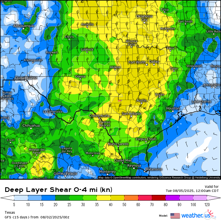
Sunday - Monday looks to be the most convectively interesting the next few days with a potential MCS or at least a few MCCs. Both Euro & GFS holding fairly strong on a formidable mid-upper northerly flow and some unusually decent DL shear this time of year (possibly over 40 knots) over a good chunk of the state on the eastern side of the furnace High moving off to the west. Steering some stout mid-level shortwave energy south through the state. Especially on Monday. Euro has been a bit sketchy on shear value trends in most recent runs. But GFS has been staying mostly consistent the past few days.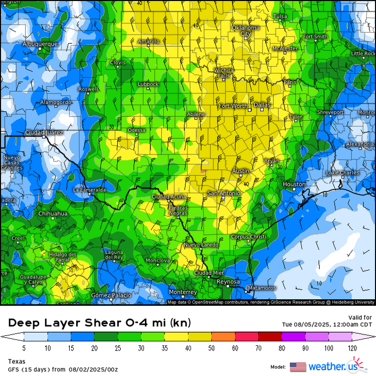
-
Texas 2025 Discussion/Observations
Stx_Thunder replied to Stx_Thunder's topic in Central/Western States
On another note, sfc dew points and humidity values were majorly below normal this time of year in the coastal bend, Tuesday. Corpus airport dew point bottomed out at 49 F with just 20% humidity value in the early evening. Well below the normal 70+ F dew point observed throughout the entire summer (day & night).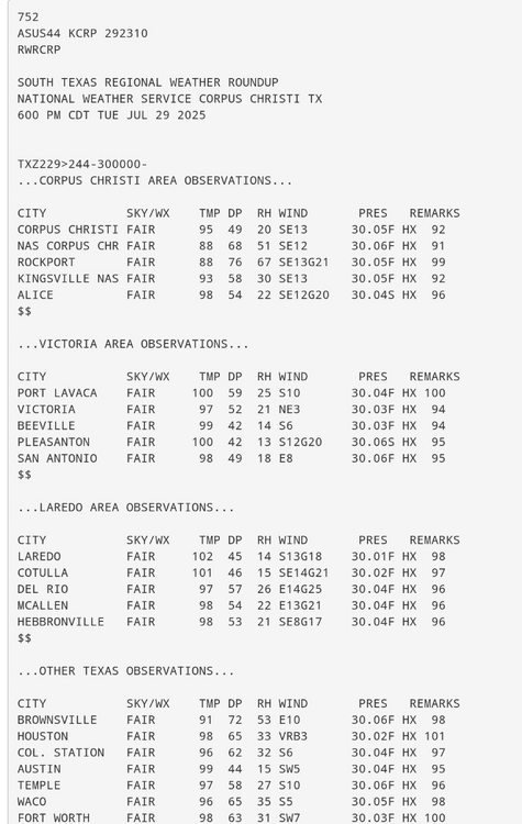
-
Texas 2025 Discussion/Observations
Stx_Thunder replied to Stx_Thunder's topic in Central/Western States
'Rest of Summer 2025 is looking good for less TX insane heat, and more convective action. - Ensembles have been pretty consistent in forecasting fleeting (rather than dominant) subtropical ridging since the season began. And I don't see any reason with forecast trends this will change much, or to disagree with CPC's month outlook for August, with equal chances on temps and precip in the state. Instead of just outright throwing in above normal probability temp shades all over the state, typically. This weekend, and possibly even later next week or into mid August is looking a bit convectively interesting with a non-tropical mid-upper level pattern developing as the flow turns North across most, if not all the central and eastern half of state due to the typical mid-upper High moving off to the west. And troughing digging further south through the Plains than usual this time of year. Which will likely push a front into the state this weekend. The AO edging into the negative phase in the coming days also supports this (as I've seen in past years). Both Euro & GFS are even starting to hone in on modest DL shear getting deeper into the state as well in more recent runs. So stronger or more organized storms are not out of the question. Especially with a +PNA phase already in place as I've also seen over the years. Only real caveat later this weekend looks to be mostly meager mid-level lapse rates around 6 (except may be 7 in NTX). Next weekend or following week is looking steeper further south.
-
No doubt there whatsoever. Especially on social media. Though I still blame some of the people who lost their lives in the Kerrville area floods. NWS (despite its slowly increasing flaws), but especially much more thanks to the Austin/San Antonio office meteorologists, did 100% do their job posting FF watches & warnings hours in advance before the flood waters from the Guadalupe river (which I've seen from my own eyes before is a big one here in TX), really started to escalate in Kerr county as it easily overflowed its banks. Accuweather meteorologist Jon Porter detailed the timeline of the watch and warnings/emergency posted July 3 - 4 on air today here: https://www.accuweather.com/en/weather-news/camp-mystic-where-deadly-texas-flooding-took-place-is-in-flash-flood-alley/1791962 - - About the 'no technology' girls camp called Camp Mystic being in a low-lying area near the Guadalupe river, I do not blame the camp for having a 'no technology' rule. Just that the camp leaders could've been more mindful of the bad weather that had already been going on in the area in the days prior when TS Barry's remnant MCV was nearing TX early last week. A NOAA wx radio (which also has a warning alarm for flooding), at least in this case would've probably been enough to save most of the lives there.
-
The remnant circulation or MCV of TS Barry was definitely there. I even saw it earlier last week on TX regional radar at night when there was less deep convective activity around it as it crawled north-northwest to north into NE Mexico (west of Laredo). Before crossing the mid Rio Grande near Del Rio, TX into the Edwards Plateau region later in the week.
-
Texas 2025 Discussion/Observations
Stx_Thunder replied to Stx_Thunder's topic in Central/Western States
It's really just a total shame that a lot of people still don't heed flash flood warnings the way they should (like they would do with tornado warnings). Especially when in a low-lying area or near a river as both are the case with the ongoing Kerrville area flood deaths. And it's not like this has never happened before in the state in recent years. I honestly thought that after what happened in Wimberley area back in spring 2015 & 2017's Hurricane Harvey remnant Low stalled for days in SETX, people around the state would've at least learned to be a bit more mindful of what flooding and 'excessive rainfall' (per WPC) actually is. Especially anything that's tropical, as the culprit of the Kerrville area flooding was in fact just like Harvey, also a remnant Low of TS Barry that made landfall in Mex from the SW Gulf last weekend (NWS Austin/San Antonio office mentioned this in AFD earlier last week). I've been seeing the remnant Low or MCV spinning on radar around the Kerrville area over the past couple days. And saw it slowly going north out of NE Mex west of Laredo earlier last week. Even an Accuweather meteorologist pointed out twice on air that FF warnings were issued by NWS, several hours before the flood waters even escalated in the county into July 4th. So I definitely think more than 50% of whatever the death toll ultimately is in the coming days, could have easily been prevented. -
Texas 2025 Discussion/Observations
Stx_Thunder replied to Stx_Thunder's topic in Central/Western States
Looks very convectively interesting (San Antonio - Houston region & south), Wednesday - Thursday this week. Severe risk with some DL shear still around, but looks to be more-so heavy rainfall and flooding now being June (precipitable water going above 2 in.) Both Euro & GFS trending up on totals near 10" in the state mainly just those 2 days from a fairly stout, slow moving upper trough diving unusually further south in the state. WPC is bound to issue moderate excessive rainfall risk over mid-coast region up to Houston/ETX for midweek. Euro EW rainfall and multi-model flash flood indexes are already quite high for Wed - Thurs also. The persistent exceptional (D4) drought level status over SAT area should abate with this week's convective setup. H5 heights are likely to drop below 590 and may even be next to 585 in STX. Which also translates to 500 Mb temps still closer to -10 C. Going below normal for June standards.

-
Texas 2025 Discussion/Observations
Stx_Thunder replied to Stx_Thunder's topic in Central/Western States
SPC D1 enhanced svr risk today over central half of state looks valid, looking at instability/shear parameters. Especially Del Rio - Houston region and south later this afternoon with a front, outflows and peak sfc heating in the region. CAMs as usual, have not been doing well on MCS evolution (even last week) over southern half. If things haven't gotten convectively interesting enough since last week in the state, they likely will next week especially now that May has arrived. To top it off, both Euro & GFS along with ensembles are showing an abnormally deep slow-moving H5 Low nearing the state with stronger ridging further north/east around mid week and lingering front in the state. 'Been like that for days now, but with LN completely gone, and the MJO hanging around the latter phases in or next to the unit circle has me more concerned looking back on past major convective events in the state this time of year like that. Flood threat is bound to increase over the eastern half with MCS activity around through most if not all of next week.
-
Texas 2025 Discussion/Observations
Stx_Thunder replied to Stx_Thunder's topic in Central/Western States
Fine TX spring wx all this week to be outside. Can't ask for more comfortable conditions in the entire state by this time of year. Was more winterlike this past weekend even in STX with below normal temps. And record snowfall in the Panhandle region.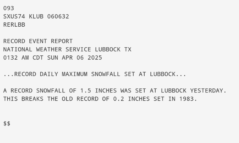
-
Texas 2025 Discussion/Observations
Stx_Thunder replied to Stx_Thunder's topic in Central/Western States
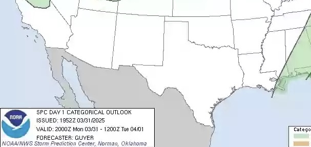
SPC, 100% dropped the ball today here in TX.. 2 in. hail reported in San Antonio at sea world, from a storm that literally popped up right over the city 2 hours ago with a front/dryline in the area and obviously a shortwave trailing east-southeast in the w/nw upper flow aloft (looking at this evening's obs sounding data). Causing a few other cells right now in STX.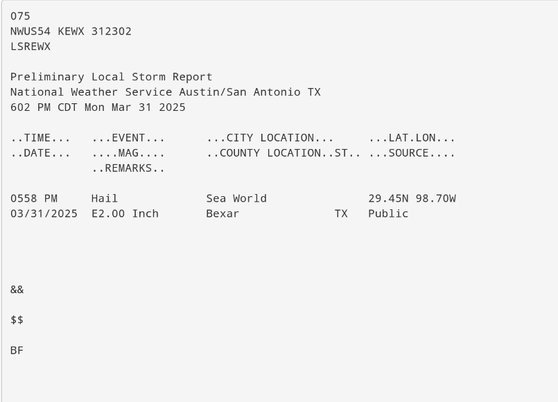
-
Texas 2025 Discussion/Observations
Stx_Thunder replied to Stx_Thunder's topic in Central/Western States
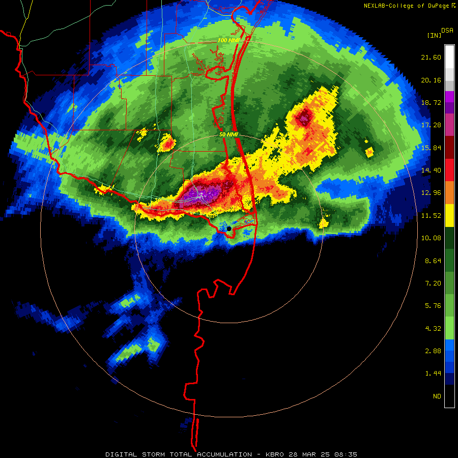
Some recap on the easily historical RGV flooding this week: https://www.krgv.com/news/hundreds-of-water-rescues-made-in-cameron-county-more-underway https://www.valleycentral.com/news/local-news/harlingen-streets-flooded-residents-rescued/ The airport in Harlingen (Valley International) is closed at least until Monday. -
Texas 2025 Discussion/Observations
Stx_Thunder replied to Stx_Thunder's topic in Central/Western States
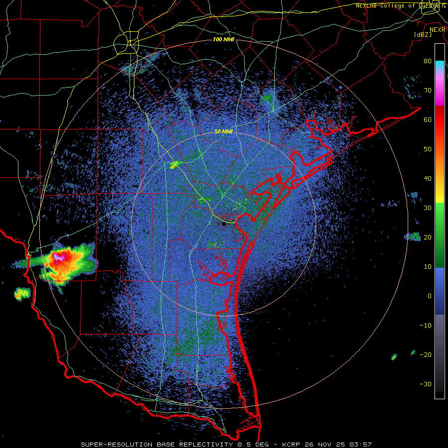
Deep STX / lower RGV is the clear winner in the convective pattern this week. Many severe warnings were posted throughout a 12-hour period starting around noon Thursday, all the way until about an hour and a half ago. One convective cluster/segment after another, moving at a turtle pace east along the Rio Grande to the coast along a stationary front. Extremely impressive storm totals in & around Harlingen (just up the road from Brownsville). Now going up to 20 inches since Wednesday afternoon! (26th)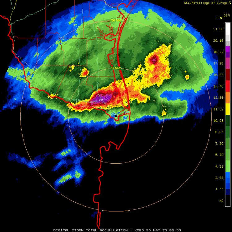
-
Texas 2025 Discussion/Observations
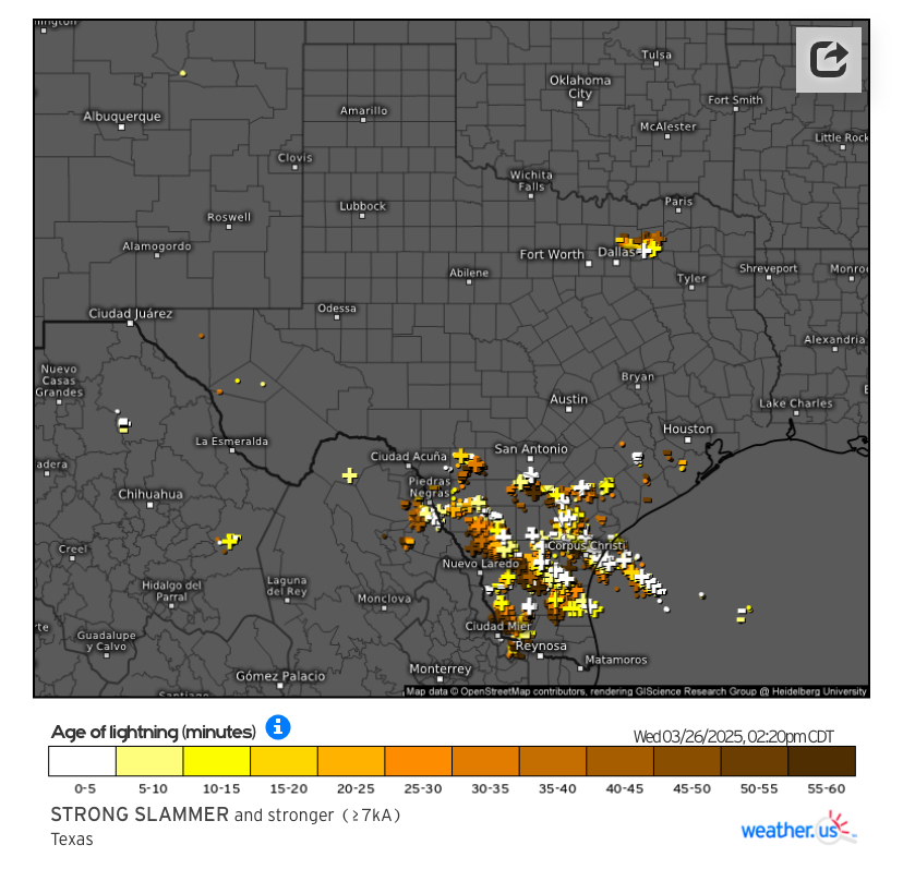
Stx_Thunder replied to Stx_Thunder's topic in Central/Western States
Finally hearing thunder again and things lighting up over the southern part of state. Good amount of +CG strikes despite it only being *just the very beginning (initial weak shortwave) of a multi-round thunder show through Friday. Convective pattern I like the most. Not sure if I can agree on WPC's decision to post 'moderate' excessive rainfall risk through tomorrow in D1 & 2 outlooks. I do like that they wrote out the "worse" and "best" case scenarios yesterday in the discussions. But there'll likely be some runoff issues in STX especially considering how long & dry it's been since the last heavy rainfall several months ago. Both Euro & GFS insistent on near 10" totals swath somewhere between San Antonio and Corpus by the weekend. Brownsville (BRO) 12z upper air obs was already showing 1.7 in. precipitable water this morning. And southeasterly flow even above H7. So it looks like 2" PW could be reached later tonight or tomorrow. Which would be getting into record territory for this time of year.