
Stx_Thunder
-
Posts
382 -
Joined
Content Type
Profiles
Blogs
Forums
American Weather
Media Demo
Store
Gallery
Everything posted by Stx_Thunder
-
Nice. Though I might question if it’s actually real (though I see the timestamp in the stream). But if it’s legit, definitely supercooled hail stones (foggy or white nuclei). I’m assuming the “cracked” area on top happened when it hit the ground before it was picked up. It kind of looks like the shaved ice that’s made or packed for snow cones. I wonder if anyone on here has seen spiked hail stones. I saw that in real life from my own eyes once back in May 2005 from an HP supercell that was about 2” diameter and picked it up. The hailstone was almost literally ‘spiked’ that it could make your hand or fingers bleed if you weren’t careful handling it, basically.
-
Evidently seeing more multicellular clustering on radar like the low BRN shear values on the late afternoon DVN & ILX soundings were indicating (rather than truly discrete supercells). I’m sure this will have a somewhat negative impact on tornado production in the risk area unless things get more discrete. - - - - - I’ve seen that a handful of times before on lightning data or radar over the years. It probably is a “false” lightning strike. But what it likely really means is that the atmosphere is electrically charged (favorable for lightning production) in that area when you see that and nothing on precip radar.
-
Number of multicell clusters literally exploded just in the past 30 minutes, just east/south of Davenport IA area. Couple of severe thunderstorm, and tornado warnings now also.
-
Not surprised as I just checked the SPC 22Z DVN (Davenport IA) observed sounding. Again similar to a few weeks ago in eastern TX, Low CAPE (282 MU), but both steep low & mid-level lapse rates. Surface temp at 72 F which I guess pretty warm for this time of year up there. WBZ height isn’t ideal for large hail, but FZL height is definitely low for more hail production. PW only at 0.57 BRN shear parameter is low at 24 which doesn’t support supercells though at least in the immediate Davenport area (mainly multicells). Gonna try to watch how this evolves as that environment aloft around there is definitely still interesting. *Edit: 22 Z or utc DVN sounding. ILX sounding just off to the southeast in central IL showing much more CAPE around 1000 & better shear parameters.
-

Texas 2024 Discussion/Observations
Stx_Thunder replied to Stx_Thunder's topic in Central/Western States
By the way, I’m assuming that was a typo for ‘South Padre Island’. But the way you wrote it is legit pretty much what it is anyway there in deep STX lol -
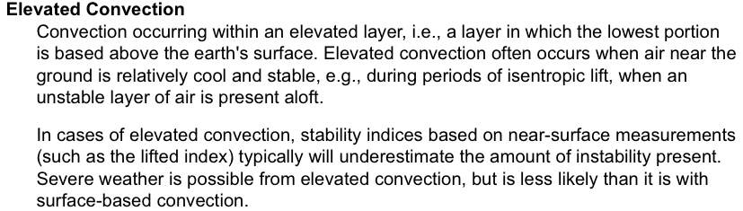
Just to reference for everyone on here in case some aren’t as informed, NWS defines ‘Elevated Convection’ on their meteorological discussion glossary as this: https://forecast.weather.gov/glossary.php - - - And I never wrote that ‘elevated’ and ‘high-based’ storms were indeed the same and I already explained what high-based normally, or better yet, logically means. ’High-based’ though, can be interpreted differently because it is not an existing term in the NWS glossary. But, SPC also uses both terms in their convective discussions (and it’s been like that for a lot of years now as I’ve seen & read). Each forecaster may very well have a different interpretation of what's actually ‘High-based’ to them. But they could also just be meaning ‘Elevated’ at the same time too because there doesn’t seem to be an actual top layer criteria that strictly defines an elevated storm, looking at that NWS definition. ’Surface-based’ is indeed in their glossary as well. But it obviously has no room for individual interpretation because it inevitably means storms that are based within the surface layer (very near the ground), as written on there.
-
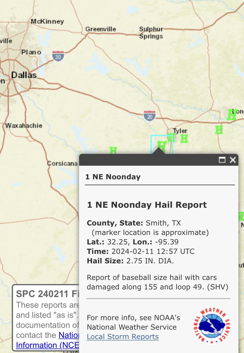
Well it seems that even very elevated storms rooted close to 700 MB, but especially, storms in majorly lower than normal CAPE environments are producing more severe/larger hail instances & lightning than before. Those baseball diameter hail reports around Tyler, TX that happened just a few weeks ago on the early morning right around sunrise of Feb. 11 (despite the favorable hail-producing environment aloft with quite cold mid-level temps this far south just below -15 C, steep mid-level LRs, and favorable shear parameters), was awfully interesting to say the least. Looking at the 12 Z FWD & SHV (Dallas and Shreveport LA) observed soundings ahead of a front, there was essentially no CAPE whatsoever in that area (including MU). I posted that info/data about it in the 2024 Texas discussion thread: https://www.americanwx.com/bb/topic/59912-texas-2024-discussionobservations/?do=findComment&comment=7228417 There was also 3.00” diameter hail reported from a fully discrete supercell between the I-10 corridor that runs from San Antonio - Houston TX on Jan. 8 (this year) also. But the environment in the area that day did have some actual CAPE on 12 Z observed SPC soundings (a little surface-based probably too) as it happened in the early afternoon. But even then, to have that kind of hail going on in early January is very unusual down around here close to the Gulf coast (looked at historical data also). As that’s normally only severe season type hail in spring. There was also a confirmed tornado report in an embedded, elevated (but likely near sfc-based) supercell in Brazoria county (near Houston TX) that happened in the very early morning near sunrise around 6:00 am last month on Jan. 5 that was also in a very low CAPE (< 500 j/kg) environment. Even though it was influenced by a warm frontal zone nearing the coast with favorable shear profiles and lapse rates aloft. The elevated storms also had a good amount of CG lightning going on that developed around TX coast when I was looking at lightning data early that morning and in another, weaker storm that developed near me. - - - Personally, looking at all those severe events I wrote above that happened this month and last month so early in the year is quite concerning to me. Especially when normal severe season this year starts next month.
-
That depends on what you’re meaning when you say, ‘high-based’. It usually means a step above ‘elevated’. High-based cells usually means that they’re rooted well aloft in the mid-levels above 700 MB (10 Kft above sea level), typically because the low-levels below that or the boundary layer all the way to the surface is too dry and/or stable. So obviously, the severe risk would be low because the depth of the storm is much shallower, if it’s actually high-based. Elevated thunderstorms usually means they’re rooted below that in the boundary layer or below 700 MB. Where they typically still have better access to more substantial warm/moist inflow (despite not being surface-based), in the appropriate environment. Usually in shallow polar/arctic frontal air masses rooted in the surface layer no more than a few thousand feet above the surface (basically a cold dome with warmer air overrunning it causing cloudiness down here in the south). So in that kind of scenario, the severe risk would obviously be higher.
-
Normally the risk of all severe hazards is virtually non-existent in very elevated or high-based storms.
-
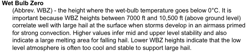
Looking back on observed soundings at what happened in Eastern TX a few weeks ago early morning of Feb 11, larger hail, especially in discrete supercells seems to really hinge on wet bulb zero height (WBZ) being in the sweet spot between 7500 - 10000 on soundings. From NWS Glossary: https://forecast.weather.gov/glossary.php * FZL, cold mid-level temps & steep LRs should be no problem this far north in this topic’s forum region or risk area. Especially being early in the season.
-
Texas 2024 Discussion/Observations
Stx_Thunder replied to Stx_Thunder's topic in Central/Western States
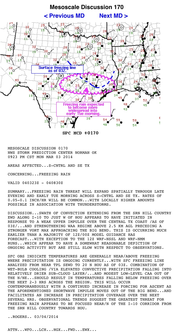
Looks like Laredo is going to reach & potentially exceed its first 100 F mark of 2024 tomorrow (before end of February), looking at those latest GFS/Euro runs today. And seeing the actual high of 98 F today (even mid 90s in DFW) out there with all this ridging/subtropical high influence that’s been going on aloft since earlier last week. It’s not extremely unusual on record in February for Laredo to reach 100 F, but there may be a 50+ degree difference further behind Wednesday’s incoming Polar or Canadian front, on Thursday. Overrunning precip activity in the state late this week not looking impressive on models, but both GFS/Euro showing mid-level LRs will be steep Thursday night with rising PW ahead of some incoming mid-upper level southern stream shortwave energy. So can’t rule some thunder activity over the southern half/coastal region. But any severe storms with the front itself entering the state Tuesday night should stay east/northeast, this time. But, things could get more convectively active again with more severe potential starting early next week as it looks like the more active subtropical jet pattern from Jan - early Feb looks to be coming back at least to an extent in March. Polar air mass intrusions aren’t really uncommon in the whole state during March and even somewhat in April, at least during the past 2 decades. I also recall the 2007 Easter weekend cold snap (which was more unusual as it got into the 30s in STX that Saturday night going into Easter Sunday). There was another notable one in 2004 Easter weekend and it was interesting both had decent elevated thunder events down here at night going into Easter Sunday. Though I can definitely recall a number of March cold snaps during the 2010s. But most notably in 2014 (March 3rd to be exact), where that was an actual Arctic origin airmass that came into the whole state. It only managed around 40 F during daytime down here in STX (and solid overrunning low-level cloudiness), so the airmass was obviously very shallow. Though I do remember looking at the 0Z March 4, 2014 BRO & CRP observed soundings. Not only that and even more interesting and awesome this time, there were actual (still elevated) thunderstorms (some fairly strong near the lower Rio Grande on VIL) going on around here in the abnormally cold overrunning environment. And north-northeast from San Antonio - SE/ETX (all sub-severe in the state as far as I can remember even though SPC was monitoring when they got going in the state that evening). As a stout mid-level southern stream shortwave was coming in from Mex. It was definitely cold enough aloft in ETX for all winter precip types (thunder sleet/graupel, snow, and freezing rain). But seeing actual CG lightning bolts going on a couple miles just behind my backyard and 38 F actual temp outside down here…, man that was just crazy awesome. There was also ample MUCAPE with that activity back then (around 1000 j/kg), to note as well. Not like these Low/very low CAPE severe events that have been happening in the state recently earlier this month and in January. Which could be concerning going into spring this year. - - - - - Here’s a snapshot of the archived mesoscale discussion SPC had put up for freezing rain that evening back in March 2014:
-
MO/KS/AR/OK 2023-2024 Winter Discussion
Stx_Thunder replied to JoMo's topic in Central/Western States
It’s been basically like that for about a week now (closer to 2 weeks of above normal temps this time of year) down here in southern TX with more unusual mid-upper level subtropical high influence nearby in Mexico. But I’m glad winter isn’t necessarily over yet for the Southern Plains into March (possibly even into late March/early April looking at recent CFS runs especially if -AO phase does indeed return), as another polar airmass intrusion all the way south to the Western Gulf is likely after tomorrow. Despite the cooling effects will only last for about 3 days down here (which is typical). -
CPC wrote an interesting and uncertain Week 3 - 4 forecast discussion just this past Friday mentioning about a potential SSW: https://www.cpc.ncep.noaa.gov/products/predictions/WK34/ I haven’t read enough into (Sudden) Stratospheric Warming phenomenon and particularly data yet, but what are the odds of this happening, going into or in March? If my memory serves me right over the past few years, I’m sure it’s also had a significant impact on the AO going back into or staying in a Negative phase longer. Which could keep winter from ending too soon over the Central US.
-
Texas 2024 Discussion/Observations
Stx_Thunder replied to Stx_Thunder's topic in Central/Western States
Apparently baseball size hail (2.75 in. diameter) was reported a little further southwest of Tyler on superbowl Sunday morning: It turned out to be more severe wx active than I thought it was going to be in ETX. Especially being early in the morning. I was a little under the weather, so I wasn’t aware of how potent the environment aloft actually was for large hail. But I definitely see why it happened around there (despite the very limited CAPE in the region), looking at the 12 Z DFW/Fort Worth sounding from that morning: - I circled the parameters of note. But particularly the FZL (freezing level), and WBZ (wet-bulb zero height) ones were definitely both in that SIG hail range. WBZ height wasn’t any higher further east/southeast on SHV & LCH soundings (Shreveport & Lake Charles LA). But anything between 7000’ - 10500’ means a heightened large hail risk. Also have to note that fairly impressive BRN (Bulk Richardson number) shear value @ 200 concerning supercell risk. (from NWS glossary: https://forecast.weather.gov/glossary.php) * Shreveport LA observed sounding: - Pretty deep, well-defined 500Mb Low out west over NM on 12Z observed sounding compiled data that morning also.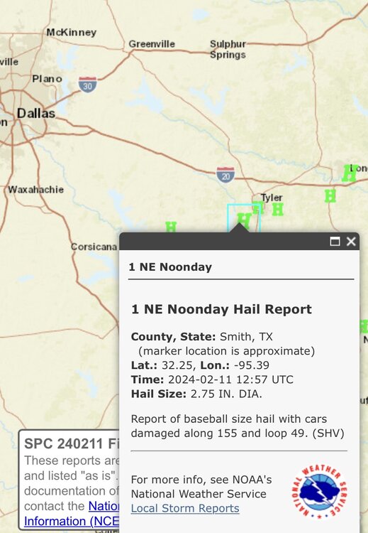
-
MO/KS/AR/OK 2023-2024 Winter Discussion
Stx_Thunder replied to JoMo's topic in Central/Western States
Interesting overrunning deep convective scenario there in MO. A very good amount of strikes recorded on lightning data today progressing east through much of the southern half of the state. I’m sure graupel and a little hail was also falling in some of the stronger storms as 700Mb (10 Kft) temps were already below 0 C this morning, and 500Mb (18 Kft) around - 20 C. Which is quite cold aloft in the mid levels for such deep convective scenario in the south. And the residual chilly airmass earlier today was extremely shallow with an E on the 12Z SGF (Springfield MO) upper-air sounding this morning. Mid-level lapse rates were fairly steep too (7 C/km). Which was also causing the substantial lightning activity. -
Texas 2024 Discussion/Observations
Stx_Thunder replied to Stx_Thunder's topic in Central/Western States
Big 850Mb cap amazingly weakened to literally almost nothing down here early this morning between 0Z yesterday evening's and this morning's 12Z CRP sounding ahead of that final, main convective line with the frontal boundary. So I actually managed to cash in on it down here. Didn't last long as it was pretty thin, but was decent with fairly frequent lightning (especially with such shallow convective tops on radar no more than about 30 Kft). Already looking forward to next round of thunder events soon lol, as that alone was a good sign in this unusually active pattern of late - But it is still looking very convectively interesting going the week of Feb 12th. Even into Feb 19th the following week. GFS/Euro & ensembles still holding onto a very unusually persistent troughing pattern for this time of year setting up out west next week of Feb 12th (at least within the active subtropical jet staying parked over northern Mexico, into TX). GFS in particular showing basically round after round of activity moving through the southern half of state during that week. SPC was also already mentioning severe potential for next weekend as well in D 4-8 outlook, earlier today (Saturday). -
Texas 2024 Discussion/Observations
Stx_Thunder replied to Stx_Thunder's topic in Central/Western States
- Main thunder line developing west of San Antonio. Latest 6Z HRRR and 0Z FV3 both showing it slicing through mid-upper coast (CRP - HOU) before sunrise. Can also clearly see that developing mid-upper level Low up there off to the west of Amarillo/southeast NM/CO border. -
Texas 2024 Discussion/Observations
Stx_Thunder replied to Stx_Thunder's topic in Central/Western States
Incoming mid-upper trough into Plains is indeed a bit negatively-tilted (looking at that backed south-southeasterly flow up there in that region) on observed 0Z 500Mb & 300Mb data this evening. That could also be because of that Omega block High that's off to the northeast near the Great Lakes region now. 500Mb Heights are now < 570 in most of TX. And we're pretty much getting into the LFQ down here of that pretty strong ULL jet streak nosing in from the west. So can't rule out some persistent stronger storms through the rest of the night at least over the southern half of state. The clusters in San Antonio region have a good chance of sustaining themselves/becoming more organized toward Houston with all the SSE inflow going on now around there too on HGX radar VWP in the lower levels this evening. And mid-level LRs are quite steep on 0Z CRP sounding (> 8 C/km between 700Mb & 500Mb) too, but.. there's that typical stout cap/EML just above 850Mb down here (though it's below 850Mb on BRO). So thunder action again doesn't look too great here in STX because of that & the incoming front tonight as there'll likely be more high-based cells like the CAMs were showing since yesterday. -
Texas 2024 Discussion/Observations
Stx_Thunder replied to Stx_Thunder's topic in Central/Western States
- Pretty long/sharp frontal convective line moving through the northern half (will likely affect DFW later on) and some pretty large discrete clusters moving fairly rapidly around San Antonio now. Some severe hail reports (< 2 in), few wind reports and a tornado report out there over the Rio Grande plains/Western hill country, but nothing too significant from what I'm seeing on report data feed so far this evening. And not seeing any real powerful lightning strikes on analysis anywhere. -
Not surprised SPC put out a Slight Risk yesterday now for primarily severe hail over TX Rio Grande plains/western hill country region for Friday - early Saturday period. CAMs want to output some formidable CAPE up to 1K (for the time of year) Friday evening from around Laredo, all the way north/west of San Antonio. But I don't think that'll happen unless the incoming trough tomorrow night does turns out to be more negatively-tilted. Convective tops looking to generally be no more than 30 Kft also which is fairly shallow. Though above 60 F surface DPs will likely be achievable in most of that region ahead of the dryline/cold front (seeing current values right now). Fairly cold mid-level temps and likely steep LRs will probably be in place again. GFS/Euro also showing 700Mb temps right around 0 C and even colder than - 15 C 500Mb temps to San Antonio by around midnight Friday night. Especially if 500Mb heights dropping < 570 further south ahead of the cold front (unusually interesting) indeed happens, and LFQ of incoming, strengthening jet streak potentially providing enhanced lift for more thunder activity further east.
-
Texas 2024 Discussion/Observations
Stx_Thunder replied to Stx_Thunder's topic in Central/Western States
Mostly boring wx this week into early next week. Though more cloud cover should be coming back and maybe some fog the next 2 days ahead of Friday night's incoming trough. Convective parameters not looking impressive Friday night and with 500Mb High out over the southern Gulf, will likely limit the quality of moisture/instability return for better storms or severe. 500Mb heights are currently above 580 here in STX on 0Z observed upper air data this evening (which is fairly high for this time of year). Models kind of over-performed on last week's thunder coverage/intensity (probly rainfall too). And the main trough that brought the last round of storms over the southern half of state last Wednesday night turned out to be more positively-tilted than forecast. I ended up missing all of that action off to the north in San Antonio & Houston regions. Though, it was funny how it cleared out very nicely on Thursday here in STX (behind that departing trough), then all the lower level clouds and dampness came right back all day on Friday ahead of another trough that caused some other storms over NTX & SETX ahead of the cold front that evening last week. ---------- Later next week could get pretty interesting as main globals/ensembles have been showing some persistent troughing setting up out west going into week of Feb 12th. -
https://www.spc.noaa.gov/products/md/md0085.html * A few reports of hail up to 2" diameter in discussion area.
-
DPs are in the 70s now here on TX coast. More than what models had been depicting during the past days. Severe storm instability and shear parameters (including sufficient mixed-layer CAPE) are looking fairly good for the southern half of TX where SPC has been expanding MRGL risk in D1 & D2 outlooks. Latest globals and especially CAM runs during today have been showing some pretty strong/organized storms (possible MCS) popping up in STX near the Rio Grande (southwest of San Antonio & Laredo) this evening and progressing fairly rapidly east/northeast. 18Z GFS showing some robust development even in western TX also this evening. ----- Already seeing some fairly major thunder going on now over northwestern Mexico (southwest of El Paso which is not too common there) on the southern quadrant of that next incoming shortwave that's got a fairly well-defined circulation on visible satellite over Arizona right now.
-
Texas 2024 Discussion/Observations
Stx_Thunder replied to Stx_Thunder's topic in Central/Western States
-
Texas 2024 Discussion/Observations
Stx_Thunder replied to Stx_Thunder's topic in Central/Western States
Thunder activity here on coast last night and this morning was fair with not a lot of lightning. Even though was 2 rounds. Apparently MUCAPE itself stayed virtually non-existent overall through the entire night (even with all the substantial south-easterly WAA aloft up to 50 kts), looking at 12Z soundings this morning. Though, convective activity was fairly organized with more widespread colder cloud tops on satellite early this morning. Actual severe and sfc-based cells looking more questionable Tuesday - Wednesday as Gulf sector doesn't look like it's really going to penetrate onshore looking at today's runs with generally 60 F DPs remaining around coast. Could still be a few (probly elevated) supercells around coast. Especially Wednesday morning. Though thankfully, much better lightning activity still looking pretty good for southern half of state Tuesday night with some actual MUCAPE around by then with still steep LRs.