.jpg.93eb8afe5d1df4d67bc0eeb78d645380.jpg)
.jpg.7cbeb4b469bd18d447fac5868c43a091.jpg)
Yardstickgozinya
-
Posts
1,408 -
Joined
Content Type
Profiles
Blogs
Forums
American Weather
Media Demo
Store
Gallery
Everything posted by Yardstickgozinya
-
.thumb.jpg.6a4895b2a43f87359e4e7d04a6fa0d14.jpg)
Central PA Spring 2026 Discussion/Obs Thread
Yardstickgozinya replied to Voyager's topic in Upstate New York/Pennsylvania
I didn't even get started on Max.because I don't know where to start. A good place to start is with his youtube reviews, i'm not the only person that finds his b******* ridiculous. Monster bomb slammer jammer killer cyclones. -
Central PA Spring 2026 Discussion/Obs Thread
Yardstickgozinya replied to Voyager's topic in Upstate New York/Pennsylvania
I don't give those channels the time of day anymore but when I did watch them Andy seemed very professional.,Ryan has completely rewrote the book on weather hype and fear mongering. Intelligent guy for that guess. -
Central PA Spring 2026 Discussion/Obs Thread
Yardstickgozinya replied to Voyager's topic in Upstate New York/Pennsylvania
Yep, there's a lot of places like that, same with these YouTube Idiots like Ryan hall and Max velocity. They're f****** up everything. -
Central PA Spring 2026 Discussion/Obs Thread
Yardstickgozinya replied to Voyager's topic in Upstate New York/Pennsylvania
I'll make 80 different accounts until they change their f****** ways. Even if it takes me a year and nine months, just like it did here. That's why they couldn't accept any members.here for nearly a year few years ago. They told everybody it was a server issue.What a lot of people probably don't know Is that was actually just to keep me out because I would a f****** torn this place to pieces until the moderators changed their ways. -
Central PA Spring 2026 Discussion/Obs Thread
Yardstickgozinya replied to Voyager's topic in Upstate New York/Pennsylvania
Who are these b**** a** m************ people? I'll make a Facebook account just to go over and make their f****** lives miserable. I can't stand s*** like that internet Hype f****** p***** c*** b****** p*****me off more than any m*********** can even f****** understand. -
Central PA Spring 2026 Discussion/Obs Thread
Yardstickgozinya replied to Voyager's topic in Upstate New York/Pennsylvania
I'm not saying that we're out in the woods. But even since last check, surface cape is waning and backing off the maryland border along with the two small areas of slightly enhanced surface velocity at least for now. We got a long ways to go though and if the sun pops out today, even for just a little bit, that's going to make all the difference. Also keep in mind, I'm only watching the surface for surface based storms. there's a lot more layers to the cake.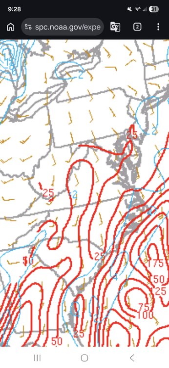
-
Central PA Spring 2026 Discussion/Obs Thread
Yardstickgozinya replied to Voyager's topic in Upstate New York/Pennsylvania
Storm chasers talked all week about chasing Dixie longneckers on sunday night. I don't know if a single rotating signature showed up last night let alone a elongated blip six. -
Central PA Spring 2026 Discussion/Obs Thread
Yardstickgozinya replied to Voyager's topic in Upstate New York/Pennsylvania
Early frontogenesis everything looked as expected, but the northern end of the front started waning much earlier, last night then everything showed. As fronts wayne they slow down so maybe that's the culprit. -
Central PA Spring 2026 Discussion/Obs Thread
Yardstickgozinya replied to Voyager's topic in Upstate New York/Pennsylvania
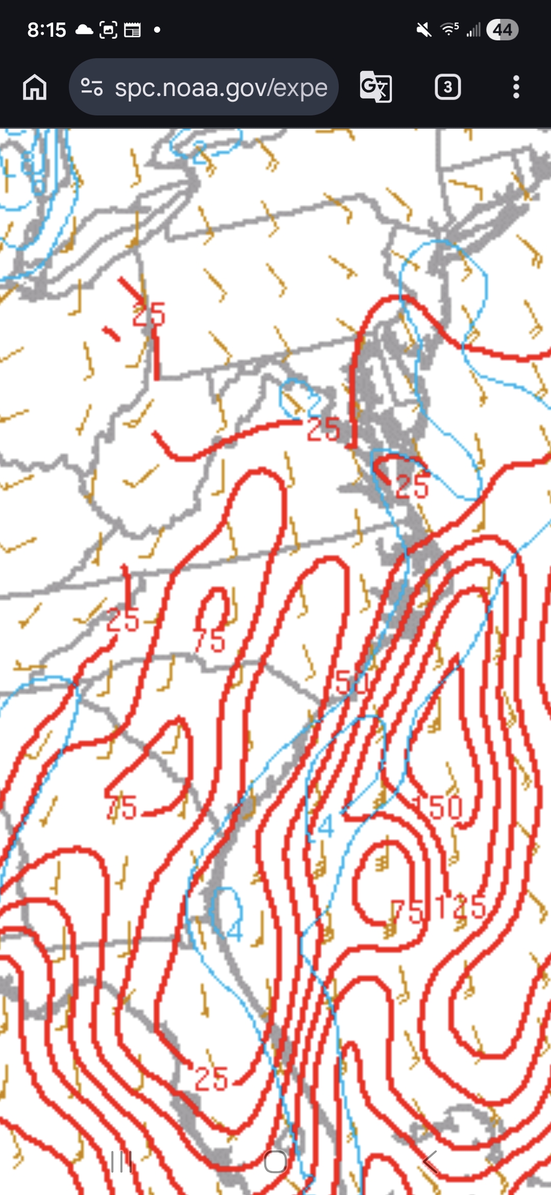
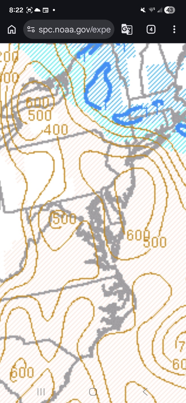
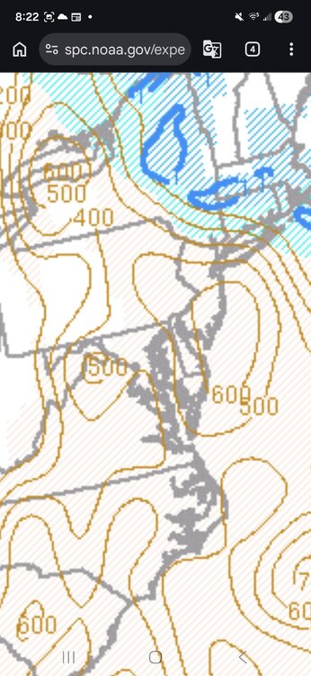
It's still early in the day, but meso scale data has been updated and at this juncture we are missing 2 of the most important parameters for tornadoes, surface cape and surface velocity (top graphic) are basically not existing at this point. There is a slight overlap in the chesapeake, but a surface cape of 25 and a surface velocity 2 is most likely not producing a tornado. There's also, some areas of extra overlaps around the Hagerstown area with some other meso scale parameters ,but nothing exceptional with this point. I'll be watching the surface all day as long as i'm not napping. We do have rising downdraft cape (bottom graphic) parameters so anyone who gets under convection or , even heavy rain might be in for a rough time. I'm sure no one needs any reminders, but I'm an idiot not a met., so make sure you're listening to your local met and not an idiot.
-
Central PA Spring 2026 Discussion/Obs Thread
Yardstickgozinya replied to Voyager's topic in Upstate New York/Pennsylvania
Highlight Changed Discussion -- 049 FXUS61 KCTP 160905 AFDCTP Area Forecast Discussion National Weather Service State College PA 505 AM EDT Mon Mar 16 2026 .WHAT HAS CHANGED... * Wind Advisories extended across northern PA and issued east of US-15 to account for gusty pre-frontal winds this afternoon. * Added details about timing of multiple rounds of showers/storms this afternoon. * Issued Winter Weather Advisory for Laurels & Northwest Mountains tonight for a thump of snow behind the cold front. && .KEY MESSAGES... 1) Gusty winds continue through this afternoon ahead of a cold frontal passage. 2) Multiple rounds of showers and storms will bring an Enhanced Risk of severe weather this afternoon and evening, with damaging winds and a few tornadoes as the primary threats. 3) Sharply colder temperatures arrive this evening with a thump of heavy snow possible across the west, and the chilly weather hangs around through midweek. && .DISCUSSION... KEY MESSAGE 1: Gusty winds continue through this afternoon ahead of a cold frontal passage. An impressive wind field continues to overspread Pennsylvania this morning and gusty south winds are expected throughout the day. Locations to the north and west of any steep terrain will continue to experience the strongest wind gusts during the day today, with sustained winds of 15 to 25mph and gusts 30 to 45 mph expected. A Wind Advisory remains in effect for the northern tier through early this afternoon, and then a Wind Advisory will go into effect for locations east of US-15 this afternoon through the evening. Note that gusty winds are expected across the entire area today and any showers or storms will tap into a very strong wind field aloft, bringing locally enhanced wind gusts. KEY MESSAGE 2: Multiple rounds of showers and storms will bring an Enhanced Risk of severe weather this afternoon and evening, with damaging winds and a few tornadoes as the primary threats. The Storm Prediction Center has continued with their Enhanced Risk (Level 3 out of 5) today. There appear to be two distinct rounds of rain that will cross the region. The first will be a pre-frontal line of storms that are currently crossing eastern Ohio and will get into our western counties (Warren/Somerset) between 9 and 10AM. As this line moves across the Commonwealth, it will encounter increasing amounts of instability (500-1000J/kg of MLCAPE) and intensify. The line is not currently producing any lightning, but lighting activity should commence by late this morning as it crosses the I-99 corridor. Damaging winds will be the primary threat with this line of storms, but a favorable low level wind profile with ~200 m2/s2 of 0-3km SRH will be sufficient for tornadoes along any portions of the line that develop kinks or discrete elements with embedded supercells. The second round of concern is when the surface cold front crosses the region. Although most of the instability will be absorbed by the first batch of storms, a potent isallobaric pressure fall/rise couplet will provide plenty of lift to produce a narrow cold frontal rainband. With 50+ kt winds just above the surface, it won`t take much to mix down strong to damaging winds. This line of rain and winds likely won`t have any lightning with it, but the wind will pack a punch as cold air pours in behind it. The cold front and associated damaging wind threat will clear our eastern counties by 10 or 11PM. QPF will be 1 to 1.5" for locations east of the I-99/US-15 corridor, and isolated 2" amounts are possible at higher elevations in Schuylkill and Sullivan County. Antecedent dry conditions should preclude any major flooding concerns, but ponding on roadways is a real possibility. If you have outdoor plans on Monday afternoon and evening, be sure to monitor the weather and consider changing your plans. KEY MESSAGE 3: Sharply colder temperatures arrive this evening with a thump of heavy snow possible across the west, and the chilly weather hangs around through midweek. This evening, once the surface cold front pushes through, colder air should rush in. At issue is how much steadier precipitation will linger behind the boundary. Given favorable upper jet placement and the probability that some wrap-around moisture will get steered into the Commonwealth, there is the potential for a quick 1-4" of snow in western portions of the state. HREF probabilities of 1" per hour snowfall rates are impressive and a several hour period of thumping snow are possible in the Laurels and northwest mountains. The latest WPC Winter Storm Outlook, which depicts probabilities of Winter Storm Warning level snowfall amounts, paints 30-50% probabilities from Somerset north to Warren/McKean/Potter County with a few pixels over 50% in McKean County. Although Warning level amounts are unlikely, the combination of favorable lift, heavy snow rates, and onset after sunset lead to confidence in at least Advisory level amounts/impacts. A Winter Weather Advisory is in effect from 21Z/5PM today through 06Z/2AM Tuesday for the northwest counties. The Advisory will continue through Tuesday afternoon (in collaboration with PBZ and LWX) in Cambria and Somerset County for lingering upslope snow showers. WATCHES/WARNINGS/ADVISORIES... Wind Advisory until 2 PM EDT this afternoon for PAZ004>006- 010>012-037-041. Winter Weather Advisory from 5 PM this afternoon to 2 AM EDT Tuesday for PAZ004>006-010>012-017-018. Wind Advisory until 11 AM EDT this morning for PAZ017-018-024- 033. Winter Weather Advisory from 5 PM this afternoon to 5 PM EDT Tuesday for PAZ024-033. Wind Advisory until 11 PM EDT this evening for PAZ042. Wind Advisory from noon today to 11 PM EDT this evening for -
Central PA Spring 2026 Discussion/Obs Thread
Yardstickgozinya replied to Voyager's topic in Upstate New York/Pennsylvania
At 4:27am there's no shortage of blips going up in the warm sector off to our south and west They'll definitely be coming into our vicinity this morning and beyond if they don't wane. Whether or not they'll help to stabilize or become something that we don't want to see is something i'll let up the professionals on this day. Things pobably needs to play out a little longer and the sun needs to come up before anyone really knows anyway. -
Central PA Spring 2026 Discussion/Obs Thread
Yardstickgozinya replied to Voyager's topic in Upstate New York/Pennsylvania
I hiked one of tornado trails as a kid with my older sister. I don't exactly remember the year but she will. I believe it was 88 or 89 and the trail was still very obvious. I have pictures of the trails and myself in front of the plaques there. I will eventually scan and post. I initially stated that it was the Albion tornado trail but that is not correct.I do know it was near the town of Albion and was a destination to hike the trails. -
Central PA Spring 2026 Discussion/Obs Thread
Yardstickgozinya replied to Voyager's topic in Upstate New York/Pennsylvania
Starting to see initiation of a fleet of cells out ahead of the front in Alabama at 2:00AM probably not good situation.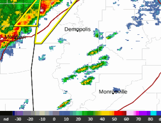
-
Central PA Spring 2026 Discussion/Obs Thread
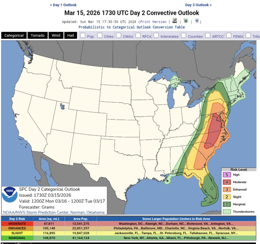
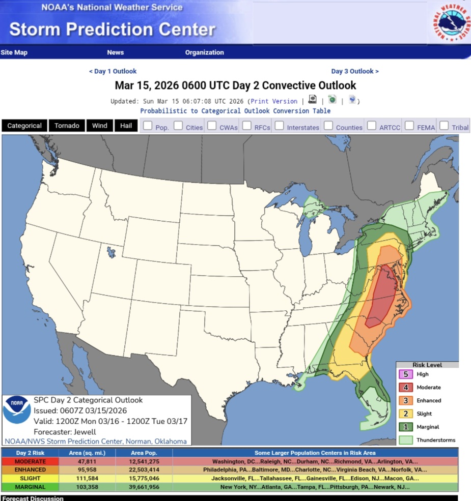
Yardstickgozinya replied to Voyager's topic in Upstate New York/Pennsylvania
12:30pm SPC update. https://www.spc.noaa.gov/products/outlook/day2otlk.html
-
Central PA Spring 2026 Discussion/Obs Thread
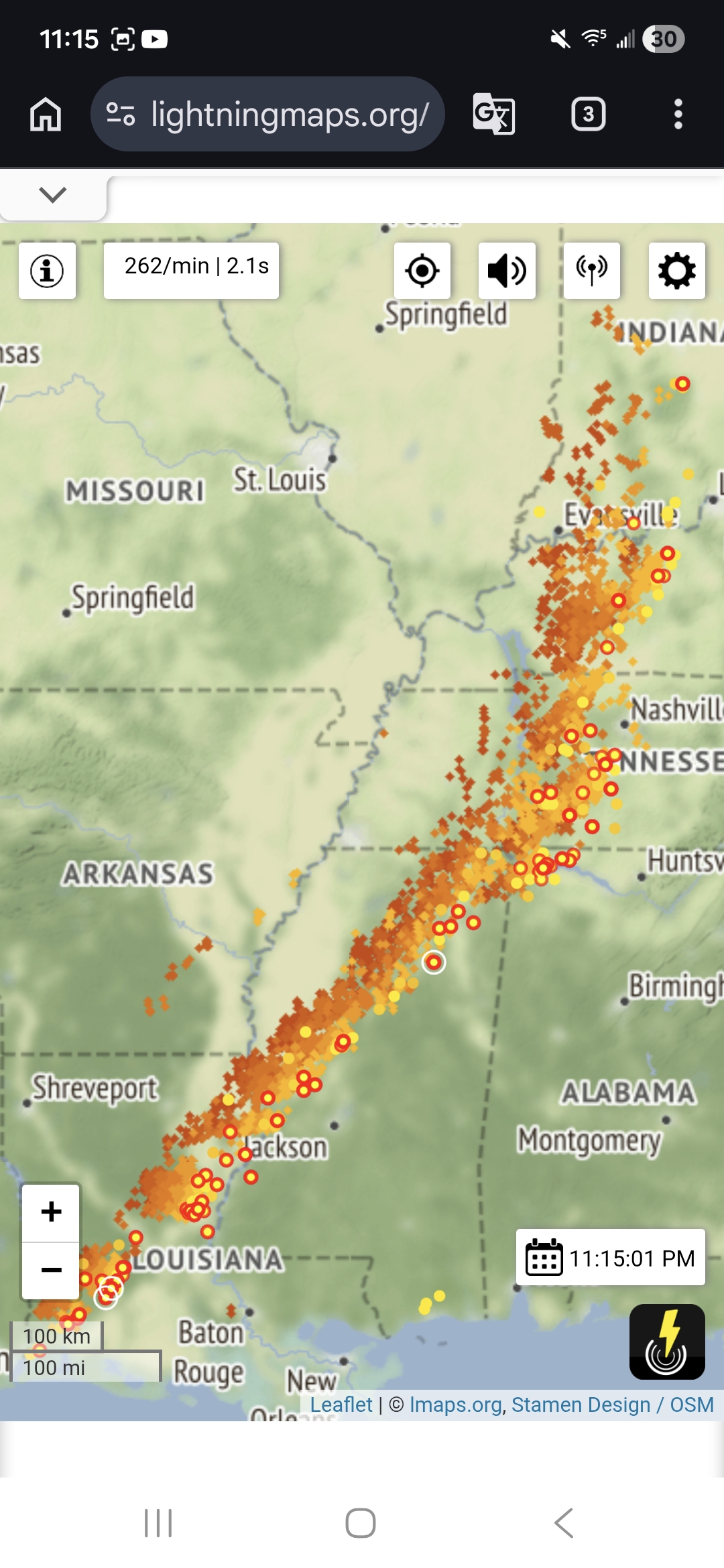
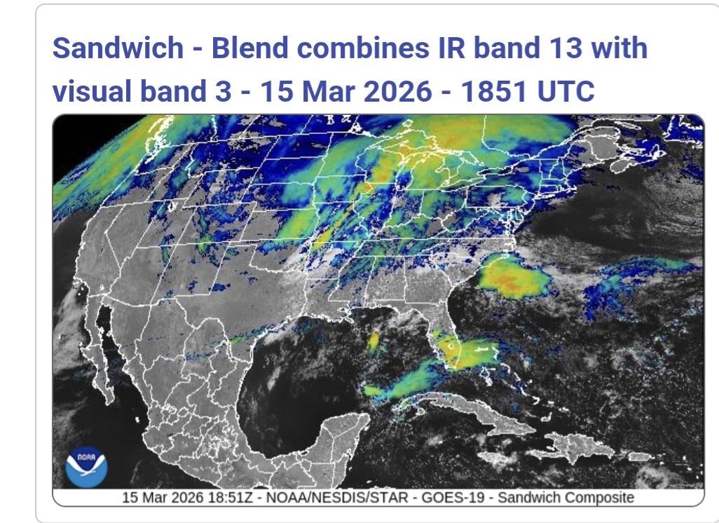
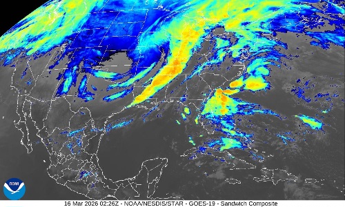
Yardstickgozinya replied to Voyager's topic in Upstate New York/Pennsylvania
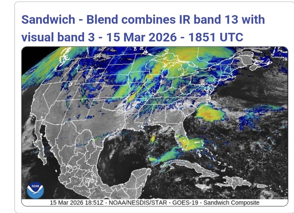
Sandwich RGB . Sorry, I had to cut off the timestamp, keys and a lot of the edges to get the file small enough. I've also included a lightning map with the last hour of detected strikes.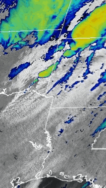

-
Central PA Spring 2026 Discussion/Obs Thread
Yardstickgozinya replied to Voyager's topic in Upstate New York/Pennsylvania
Starting to come together, Pepper, starting to come together. The frontogenesis starting at 6:41pm up until the last frame of the gif at 8:51 pm was pretty fricking, incredible. I wanted to include the sandwich RGB loop, but the files are too large.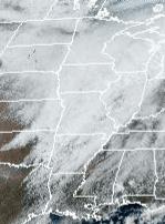
-
Central PA Spring 2026 Discussion/Obs Thread
Yardstickgozinya replied to Voyager's topic in Upstate New York/Pennsylvania
Just observing where things we're heading. -
Central PA Spring 2026 Discussion/Obs Thread
Yardstickgozinya replied to Voyager's topic in Upstate New York/Pennsylvania
Hopefully nothing now. -
Central PA Spring 2026 Discussion/Obs Thread
Yardstickgozinya replied to Voyager's topic in Upstate New York/Pennsylvania
Everybody in this forum's compassionate person. Nobody wants to see anybody get hurt and not one single gripe. Orbit of excitement is going to change any of it g******** I came back and edited this because not everybody in this forum is compassionate towards life and property but I do believe or sub is. -
Central PA Spring 2026 Discussion/Obs Thread
Yardstickgozinya replied to Voyager's topic in Upstate New York/Pennsylvania
JUST SPEAKING, HONESTLY HERE, I'M NOT TRYING TO BE AN A****** TO ANYBODY, OKAY. IT'S ALREADY OBVIOUS TO ME THAT SOME PEOPLE WANNA GO TO THE HYSTERIA ROUTE THAT IS FINE MAYBE IT'LL BE WARRANTED , BUT THERE'S NO REASON WHY OTHER PEOPLE HAVE TO FEEL THAT WAY? THAT'S ALL, I'M GOING TO SAY ABOUT IT. SO PLEASE DON'T GET ON MY BACK BECAUSE I'M GOING TO BE EXCITED AND I'M ALSO GOING TO BE PRAYING FOR THE PEOPLE IN THE PATH. AND IF THERE IS DAMAGE AND PEOPLE NEED HELP. GUESS WHO'S GOING TO BE THE FIRST PERSON POSTING PICTURES, ACTUALLY HELPING PEOPLE OUT. MY POINT IS, IF EVERYBODY'S NOT FREE TO EXPERIENCE THIS THE WAY THEY WANT.I'M GONNA LOSE MY F****** S***. -
Central PA Spring 2026 Discussion/Obs Thread
Yardstickgozinya replied to Voyager's topic in Upstate New York/Pennsylvania
Two moderate risks since 2018 . -
Central PA Spring 2026 Discussion/Obs Thread
Yardstickgozinya replied to Voyager's topic in Upstate New York/Pennsylvania
We've had several moderate risks.There's been at least two in the last couple of years. And then theres May 31 1999 High Risk. Although they all had their damage and problems, none of them we're locally catastrophic. -
Central PA Spring 2026 Discussion/Obs Thread
Yardstickgozinya replied to Voyager's topic in Upstate New York/Pennsylvania
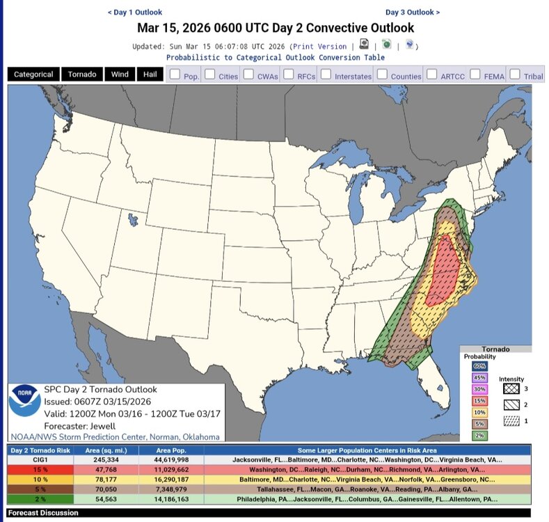
Spc's new severe wind and tornado probability outlook.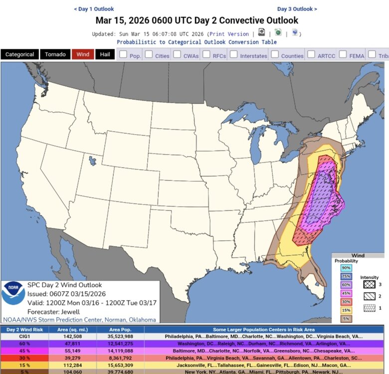
-
Central PA Spring 2026 Discussion/Obs Thread
Yardstickgozinya replied to Voyager's topic in Upstate New York/Pennsylvania
New update from the Spc . A zone of moderate risk has been added. Its definitely not looking good fellas, and I don't know that things will de escalate, at least on paper so let's hope for a thermodynamic failure at the lowest levels because the crazy, kinematics seem pretty eminent. Full discussion is in the link below the map. ...Carolinas into MD/PA and vicinity... Areas of showers may occur early in the day especially but should rapidly lift north, allowing areas of heating and gradual destabilization over the entire area. As the surface trough deepens, low-level wind will back and strengthen throughout the day. Supercells producing tornadoes appear most likely ahead of the cold front from SC into NC and southern VA. Models vary with degree of instability, but strong tornadoes do appear possible with effective SRH of at least 300-400 m2/s2. Fast storm motions over 50 kt suggest a long tracked tornado will be possible https://www.spc.noaa.gov/products/outlook/day2otlk.html
-
Central PA Spring 2026 Discussion/Obs Thread
Yardstickgozinya replied to Voyager's topic in Upstate New York/Pennsylvania
Back many years ago I was cat fishing the Marietta bend below chickies rock when a suspected meteoriite made impact somewhere in lancaster. Whatever tonight was was also many magnitudes, brighter and louder then that.