

Winterweatherlover
-
Posts
1,109 -
Joined
-
Last visited
Content Type
Profiles
Blogs
Forums
American Weather
Media Demo
Store
Gallery
Posts posted by Winterweatherlover
-
-
13 minutes ago, RU848789 said:
UK way east with limited precip for NJ, except near the coast and into NYC, with most of the precip NE of NYC; also too warm for snow for the 95 corridor...


An inch of liquid still woulda been a foot of snow if we had a cold airmass meh or got a track like this in Jan/Feb.
-
 1
1
-
-
12z Ukie not on board for nyc snow, gfs kind of on its own right now.
-
19 minutes ago, RU848789 said:
Odd, surface low is closer to us on the CMC, but has no precip at all over NJ during the time where the GFS is hammering us despite being further away (same SLP). I'm not a met, so can't explain that one, lol (maybe less NS interaction?)


Cmc seems to be focusing on eastern low, gfs on the western one. Could go either way.
-
1
-
-
Cmc not gonna do it for us this run.
-
2 minutes ago, RU848789 said:
CMC looking similar to the GFS through 0Z Tues...
Seems stuck on hour 60 but also has two lows now.
-
2 minutes ago, SnoSki14 said:
It could still be trending as 6z trended better first. A stronger, more tucked solution is feasible and that would lead to something really good.
Yes as I said last night we want tucked in this time around. Can’t worry about rain if we don’t have a storm.
-
Just now, EastonSN+ said:
This GFS run is as perfect as you can get. Small chance but it's a chance.
Have to see rest of 12z suite to see if a new trend or a fluke.
-
3
-
-
Just now, romba said:
2 lows, drawing is back in

If the western low is dominant it will be game on. If not it’ll stink.
-
1
-
-
Just now, RU848789 said:
GFS much improved!

The frames after that get even better to the coast, big improvement.
-
1
-
-
Just now, jdj5211 said:
Yes GFS slightly west and deeper than 6z. Still warm for us unfortunately
Seems to have two lows, hope the western low becomes the dominant one.
-
Gfs looks west and stronger this run to me.
-
Just now, cleetussnow said:
I have been hanging tight with some snow north of 287 which is one of those r/s lines. If it goes to 84 I am toasted. I live right smack in between those phase lines.
287 traditionally has been the classic divider but this winter it’s been 84.
-
1
-
-
4 minutes ago, LibertyBell said:
Give it to 12z tomorrow. But yes expecting more than a couple of inches around here is being very optimistic. Great for places 50 miles or more to the north or west though.
Yea for my area probably can give it until 12z tomorrow as long as it doesn’t trend worse since some models have me really close to several inches but I’m tired of being on the edge and usually being on the edge means more rain less snow. Anywhere southeast of I84 feels like the tropics this winter.
-
1
-
-
My towel is in my hand if we don’t see major changes by 12z today I’m about to throw it.
-
 1
1
-
-
On 3/9/2023 at 5:03 PM, Winterweatherlover said:
I'm not expecting 2-3 inches where I live so you can imagine what I think of the 2-3 inches down to JFK unless you get Norluned lol.
Well guess this outdid even my own low expectations since no accumulation at all.
-
1
-
-
RGEM looks slightly improved to me but I’d say we are running out of time for only slight improvements.
-
Don’t want to be negative but relying on long range NAM for hope is likely to lead to dissapointment.
-
6
-
-
2 minutes ago, dWave said:
Got a rain snow mix now, on TV I see the more steady wet snow in Manhattan as well as traffic cams approaching GWB.
.76" rain here, T snow
Guess the cold air is coming west to east or is it another batch of heavier precip to the west?
-
As expected the precip is just way too light to stay all snow or stick.
-
13 minutes ago, Bxstormwatcher360 said:
Its been snowing here for an hour now,trees and grass are a bit whitened also.

I’m just north of you and it’s light snow but nothing sticking.
-
1 minute ago, EastonSN+ said:
This is the track needed for LI and NYC. This storm does it north and over land. Obviously just showing track 1888 was wayyyyyyy more intense.

Agree that’s the track we need in case and maybe even more crucial earlier intensification.
-
 1
1
-
-
5 minutes ago, EastonSN+ said:
What stinks is if this deepened stalled and looped like 1888, 1978 this would have been 15 plus for CPK and LI. It all happens too late
The winter of what ifs. Everything that can go wrong has basically gone wrong. Only one storm on 2/28 sorta worked out.
-
1
-
-
5 minutes ago, CPcantmeasuresnow said:
2.3 inches here brings the seasonal to 18.5.
31.8 with light snow. Already melting off driveway.
You might double your season total on Tuesday.
-
1
-
-
1 hour ago, EastonSN+ said:
NYC, LI and coastal NJ will be tough, however like you mentioned intensifying a bit further south and closer and the aforementioned locations can get accumulating snow.
Massive massive potential for 84.
Same old same old always tough at the coast. The latest runs actually look a little better for LI but who knows. I’m still not expecting much of anything at this point. I’m tired of expectations being disappointed so I expect nothing and will be surprised if we get snow.
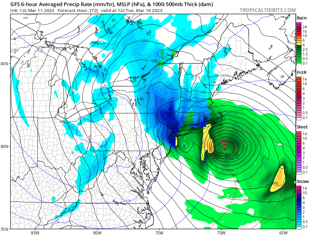

March 13-14th Nor'easter Threat
in New York City Metro
Posted
Yea and in this storm NYC realistically needs 2 inch plus qpf for something big because at least half of it is likely rain.