

Winterweatherlover
-
Posts
1,109 -
Joined
-
Last visited
Content Type
Profiles
Blogs
Forums
American Weather
Media Demo
Store
Gallery
Posts posted by Winterweatherlover
-
-
7 minutes ago, LibertyBell said:
With our luck that norlun is going to hit either Toms River or the Hamptons lol.
It almost always hits the Toms River area (if it happens at all) but yes as weird as it sounds I'd actually be more optimistic near Toms River or the Hamptons than in NYC for this because they will be closer to the ocean storm dynamics.
-
 1
1
-
-
5 minutes ago, EastonSN+ said:
A norlun trough can be extremely heavy. Also this low is intense.
I like the optimism. We'll see. I know I'm being negative but I personally don't like the setup or see why people think they'll be heavy snow. This seems like light to moderate with maybe a quick heavy burst for like an hour early Saturday morning.
-
1
-
-
5 minutes ago, NJwx85 said:
The 18z GFS now has the system suppressed way out to sea.
LOL is my only reaction (sorry if inappropriate)
-
1 minute ago, LibertyBell said:
what do you think of the 2-3 inches right down to JFK lol
it reminds me of January 2008 (but that was in January!) when we had snow here but all sides of us were raining lol
Busted heavy snow warning, the last one ever issued.
I'm not expecting 2-3 inches where I live so you can imagine what I think of the 2-3 inches down to JFK unless you get Norluned lol.
-
1
-
-
2 minutes ago, MJO812 said:

Looks almost the same as 2/28 except noticeably less north shore of Suffolk. I'm still having a hard time buying those totals in NYC and the immediate NW suburbs but hopefully Upton knows something I don't.
-
2 minutes ago, LibertyBell said:
I'll be happy if it flips over by 2 am
2 am would be fine. That’s a 5 hour window for accumulation.
-
1
-
-
1 minute ago, NJwx85 said:
Be happy that most of this falls at night because if it was falling during the day this time of year it would just be white rain.
I’m honestly worried NYC Metro won’t flip over until the morning. Maybe I’m too negative but I don’t like these latest trends with a warmer start to the storm that usually never ends well.
-
1 minute ago, NJwx85 said:
The 18z GFS has a very sharp cut off South of I-287-I-87 in Rockland.
Yea this seems to be where the models are going with this. Not gonna rely on the 3k NAM for hope.
-
Obviously upton likes this event more than I do because I’m under a WWA and expecting an inch at best. I think you’ll have to get to the I287 corridor to see 1-3.
-
2 minutes ago, LibertyBell said:
I'm dubious of 1-3 inch amounts with that low temp of 33.
If it doesn’t accumulate by 7:00 am it’s over for the city. Daytime snow above freezing no chance in the city. The recent models seem to delaying the changeover from rain to snow.
-
I’m expecting less than an inch at y
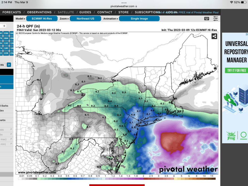
Just now, EastonSN+ said:Central Park forecast on NWS
Friday NightRain before 10pm, then rain and snow between 10pm and 1am, then snow after 1am. Low around 33. Wind chill values between 25 and 30. Southeast wind 9 to 15 mph becoming northeast after midnight. Chance of precipitation is 100%. New snow accumulation of 1 to 3 inches possible.That’ll probably change soon imo.
-
Close to throwing in the towel. This just likes a very crappy setup SE of I287. Someone somewhere may get Norlun surprise but not counting on it.
-
Just now, hudsonvalley21 said:
Hopefully both aren’t paste jobs. Especially with the 2nd event if there’s a wind factor thrown in there.
3+ inches of qpf for the HV of mostly snow from the two storms. Probably too good to be true but should be a fun week up there.
-
1
-
-
37 minutes ago, hudsonvalley21 said:
I do believe the QPF for Friday night/ Saturday event is in there too.
Nope the posted qpf maps before were all for storm 2 (didn't include the first storm).
-
1
-
-
29 minutes ago, EastonSN+ said:
Yes it would it would snow down to Atlantic City.
It would change to snow down to ACY but places near the coast could lose a lot of qpf to rain at first. I think we have to consider that as a reasonable possibility.
If it’s a euro level bomb though could also legit backend snow 1-3 inch/hour rates.
-
1
-
-
6 minutes ago, SnoSki14 said:
The Ukie & Euro were nice but 5 days is an eternity
I’m pretty confident gfs is wrong about barely any storm. Beyond that I don’t know what will happen.
-
2 minutes ago, David-LI said:
Is the trend our friend? We are still a few days away.
The 12z runs were way better than the 0Z runs so for now yes, could still change a lot in either direction.
-
The timing is part of the problem for the coast, it starts around 5 pm Monday so after a full day of warming. However I've sort of seen this setup before and it usually changes over faster than modeled but then mixes throughout the storm. As depicted this is probably sloppy at the coast and a bomb inland but we'll see if there are any trends.
-
2 minutes ago, MJO812 said:
Way better than past runs
Hopefully it stays
I mean just an absolute monster qpf bomb and sub 970 low, I would sign up for the Euro run today even if half the storm is rain imby.
-
1
-
-
NW NJ and the HV just got Euro'ed. Coast flips to snow at the end.
-
1 minute ago, NJwx85 said:
It's mid March. A track like this in January/February would have produced for everyone but that time has long since passed.
A track like that at that strength should produce for everyone in mid March, just not enough cold air I guess. Still could see it trending a little colder if it's really as strong as the Euro.
-
1
-
-
Mixes at the coast by 120, huge hit inland.
-
Having a real hard time changing over at the coast even with a good track
-
1 minute ago, winterwx21 said:
HRRR did very well with the last event even in its long range, so we can hope it's correct with the cold snowy solution it showed on the 12z run. But too many other models don't look good for us to be optimistic for areas closer to the coast right now.
Snow to rain scenarios almost always seem to do better than rain to snow scenarios near the coast so not surprised this is trending worse without powerful dynamics.
-
1
-


March 13-14th Nor'easter Threat
in New York City Metro
Posted
Ok thats not way out to sea.