

Winterweatherlover
-
Posts
1,582 -
Joined
-
Last visited
Content Type
Profiles
Blogs
Forums
American Weather
Media Demo
Store
Gallery
Posts posted by Winterweatherlover
-
-
5 minutes ago, Metasequoia said:
1996, 2006, 2016, and 2026...
1996 and 2016 probably the best. This is up there though
-
15 minutes ago, dWave said:
Hard to measure snow. multiple measurement range from 11" - 18" Around 15" is best estimate.
Snow band remains just to the west, and due south. Been in flurries for the last few hours here, but snow starting to pick up some now. That band seems to not want to move east of the Bx River Pkwy so far..
Wild how banding works seems much of the NW Bronx/Yonkers area is over 20 inches even though it’s further from the storm than eastern Bronx.
-
 1
1
-
-
I feel really old atm, I went outside and part of me felt this is too much.
-
 2
2
-
 1
1
-
-
6 hours ago, MJO812 said:
Gfs !


Not sure where they’ll put the snow on the NJ coast if this verifies!
-
6 minutes ago, SnowGoose69 said:
Bit of a model battle on the Thursday event. I sort of lean towards a flatter idea now but the setup looks sort of disjointed on many ensembles. Not sure anything over 2-4 is realistic.
To be honest after today and the aftermath id rather a small 1-3/2-4 inch type storm to whiten the snow than another big storm.
-
Down to very light snow now although not sure if there is still another band that has to push east and move through.
-
7 minutes ago, Brian5671 said:
A+ by the GFS-a week out seeing it.
If any storm has a Boxing Day type look just ride the gfs I guess lol
-
4 minutes ago, eduggs said:
The NBM and the western leaning models were too aggressive, especially a day or two ago. But the eastern-most models were too dry/east.
Yes this will be analyzed differently depending on location. Seems the heaviest snow axis was higher and more widespread than the non American models had it but the western cutoff was sharper and further east than some runs. Neither is super surprising knowing how these storms tend to go.
-
3 minutes ago, eduggs said:
This has been one of those winters where the stats say it's been a solid winter, but places to the east have consistently cashed in more on every event, which sours it just a touch. It would probably have been better not to check this forum or the radar.
I can get that, it’s the comparison to others phenomenon.
-
So both significant snowstorms over performed this winter in NYC metro, can’t do better than that!
-
5
-
1
-
-
7 minutes ago, MANDA said:
GFS for the epic win and IMO the RGEM for the epic fail. Even more so than the EURO IMO. I am just more shocked with the RGEM for a complete failure especially 36-24 to 12 hours prior to the event. Just horrendous.
RGEM tends to have a dry bias I think.
-
2 minutes ago, MANDA said:
Times Square Locations | EarthCam Construction Camera
The "heat" of midtown giving the snow a hard time.
Looks like it’s barely snowing there.
-
5 minutes ago, Jt17 said:
Heaviest totals are definitely more north and even west than most models showed earlier today, but a sharper cut off in totals out west perhaps.
.Agree with this, seems NYC and even immediate northwest burbs will do really well but 50 miles or so NW and especially west is cutoff.
-
1
-
-
1 minute ago, eduggs said:
That 01z HRRR run shows a lot less QPF for western NJ and EPA than modeling I saw a day or two ago. I hope it's wrong but radar returns are indeed having difficulty pushing west into PA.
Unfortunately this seems very similar to boxing day, I believe that's where the sharp cutoff was then too. Seems if anything the cutoff is more west vs east than even SE vs NW.
-
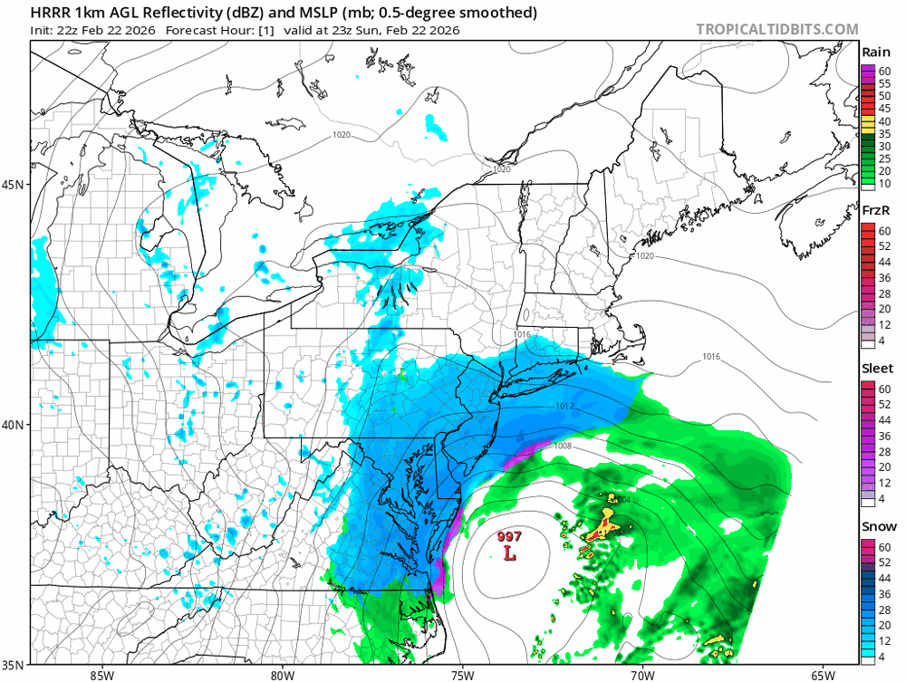
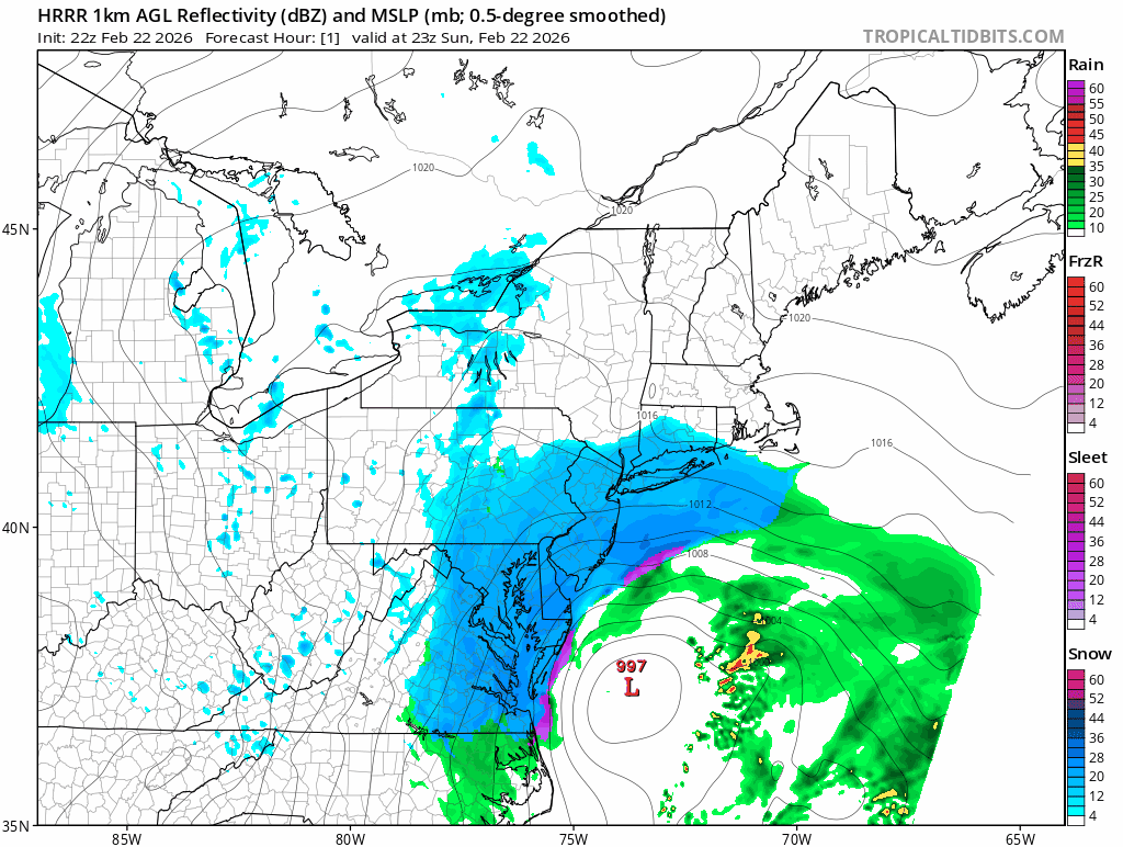
6 minutes ago, SACRUS said:
HRR from 8PM today to 2PM Monday -- On top of snow through 8pm fallen already--


wow the numbers just keep going up.
-
Just now, Bxstormwatcher360 said:
13 inches for my area??..sounds good..only problem is Im approaching half of that fast. 5.2 down already. Hvy snow currently.

That's not including most of whats already fallen.
-
1
-
-
7 minutes ago, SACRUS said:
2/23 00z nam
this is on top of everything from 7pm on
Snow

The nam is such a weird model, this is basically what it showed last night then cut back now back to this.
-
4 minutes ago, SACRUS said:
00z RAP
6AM down to 28 NYC

Will the temp or the amount of inches be higher at 6 am is the question
-
13 minutes ago, TriPol said:
I don't know why some people are disappointed with this storm. Everything is proceeding as I have foreseen.
I was starting to have some doubts after the poor model shifts earlier today but it's pounding out and seems the recent models have upped totals again.
-
1
-
-
3 minutes ago, SACRUS said:
For prosperity the 2/22 18z EURO AI AIFS
Snow

That looks good especially if thats on top of what's already accumulated.
-
5 minutes ago, NJwx85 said:
Storms like this only happen once or twice a decade if we’re lucky. I had 22” from the storm in January but that was due to many hours of moderate snow with no wind. This one is truly special. Can’t recall ever seeing blizzard warnings this far inland.
Personally I'd enjoy the 22 inches and moderate snow with no wind more but I get where people find these extreme storms exciting too.
-
3 minutes ago, NJwx85 said:
Still snowing 18hrs from now.
If only the storm went NE instead of ENE over the next several hours oh what could have been forum wide but still a great storm.
-
9 minutes ago, weatherpruf said:
yeah this is all quite confusing; someone will post something saying its going west, another will post that its cutting back.
Too many models in my opinion. Creates too much confusion.
-
1
-
 1
1
-
-
3 minutes ago, Rjay said:
No. They literally aren't comparable
Overall setup and strength is definitely not comparable. Snowfall amounts may be comparable or even less this time especially NW of I95.


The Allsnow Blizzard of 2026
in New York City Metro
Posted
Ridiculous about schools open but expected