MDScienceTeacher
-
Posts
332 -
Joined
-
Last visited
Content Type
Profiles
Blogs
Forums
American Weather
Media Demo
Store
Gallery
Everything posted by MDScienceTeacher
-
we do.. just like once every 7-9 years.
-
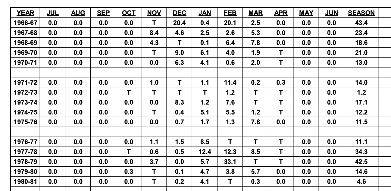
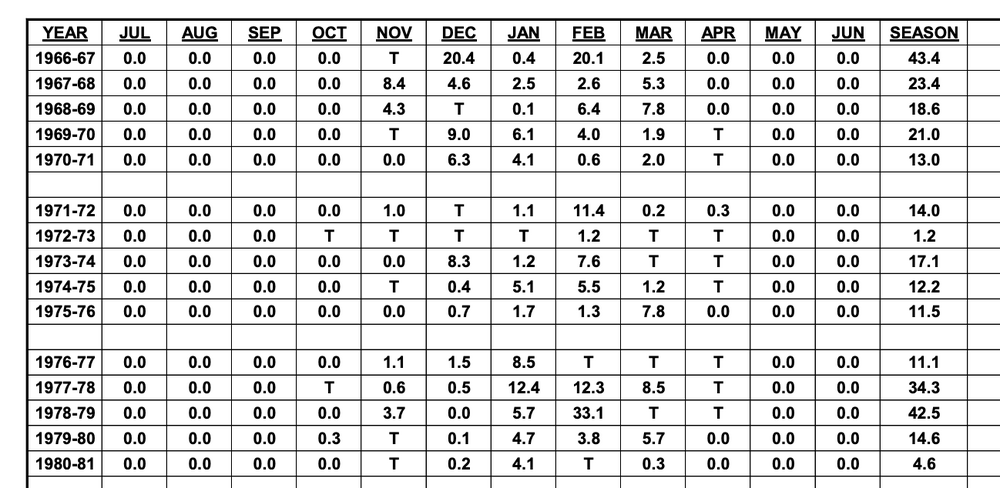
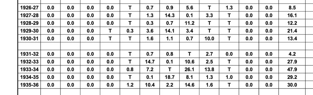
26-32 was particularly bad:
-
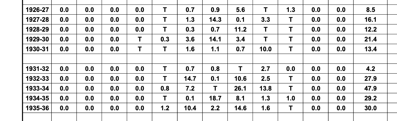
And 68-77:

-
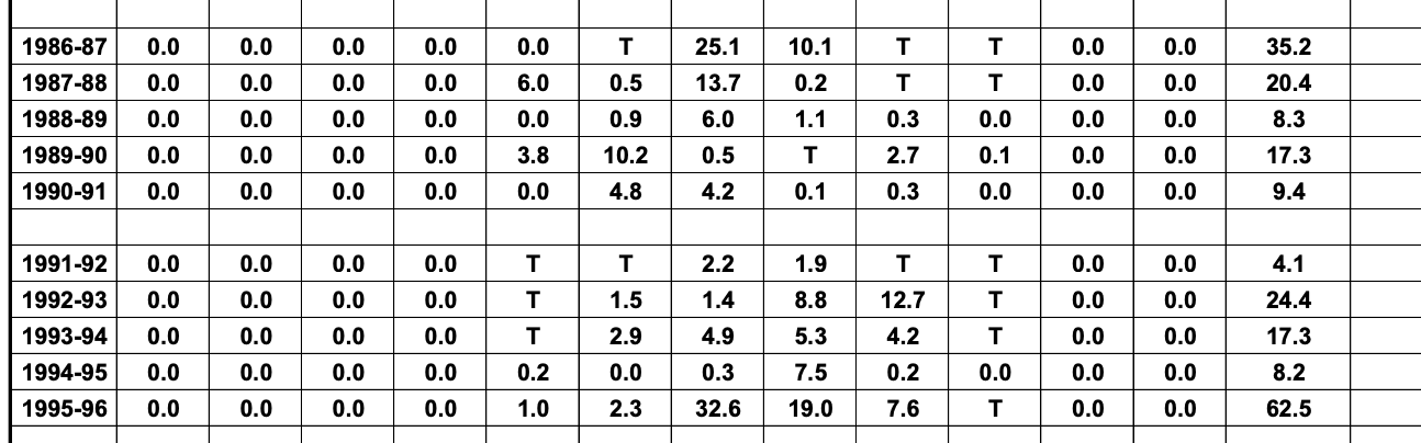
We have had stretches like this before. This is BWI: 86-95
-
1/19 - The Roulette Wheel 29 Black Storm - OBS
MDScienceTeacher replied to DDweatherman's topic in Mid Atlantic
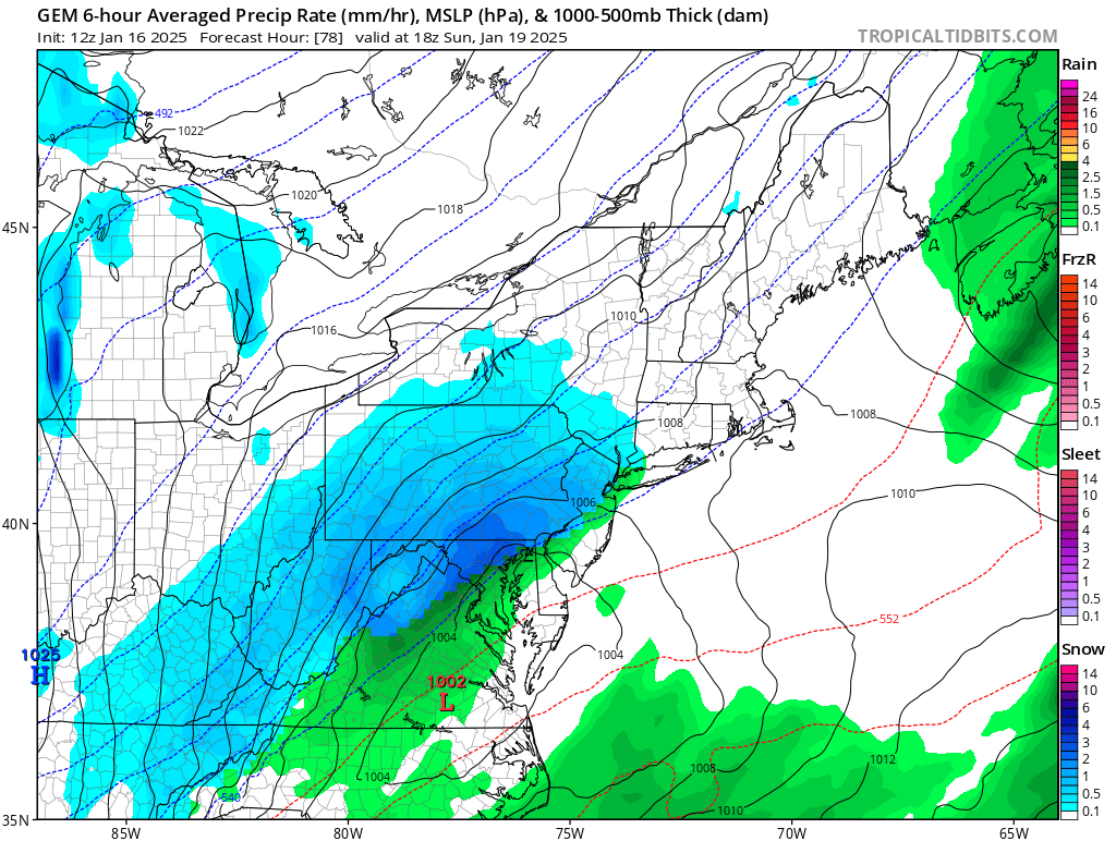
I guess it depends on where you are but I am in Ellicott City and its already snow. -
1/19 - The Weekend Roulette Wheel Thing
MDScienceTeacher replied to DDweatherman's topic in Mid Atlantic
I am not saying it is right by any means, but if you are looking for ways to fail, the NAM does look a lot like the Euro Op. -
1/19 - The Weekend Roulette Wheel Thing
MDScienceTeacher replied to DDweatherman's topic in Mid Atlantic
the last storm (Jan 6) it was spot on at 84 hours. -
1/19 - The Weekend Roulette Wheel Thing
MDScienceTeacher replied to DDweatherman's topic in Mid Atlantic
The run to run consistency on the AI for this event is almost astonishing. I just went back 19 runs and it never waivered. Here is what is what is looked like at 186 hours: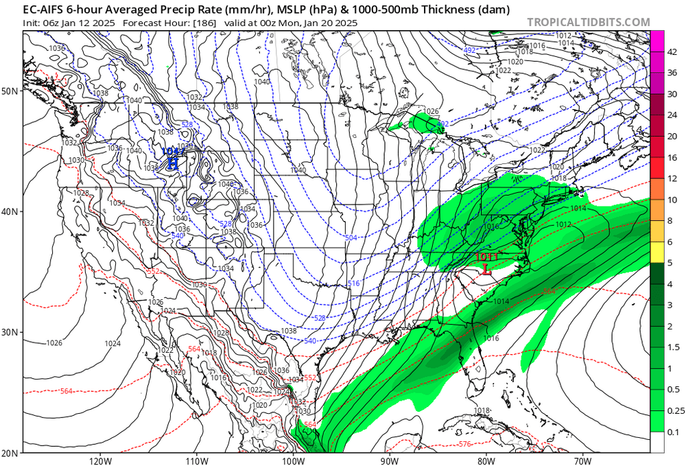
-
January Medium/Long Range: A snowy January ahead?
MDScienceTeacher replied to mappy's topic in Mid Atlantic
The trend on the GEFS is promising. Almost every member shifted west since the last run.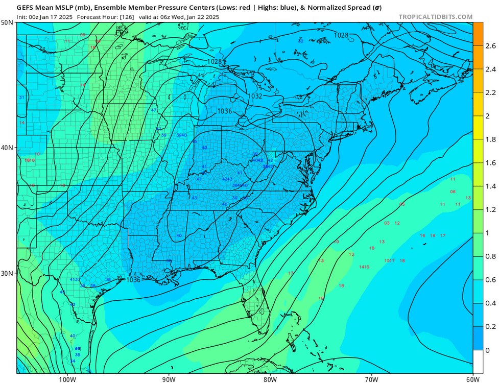
-
1/19 - The Weekend Roulette Wheel Thing
MDScienceTeacher replied to DDweatherman's topic in Mid Atlantic
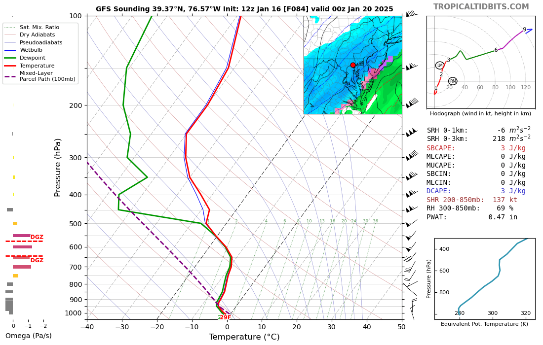
For some reason the sounding is not available on the cmc on ttb -
1/19 - The Weekend Roulette Wheel Thing
MDScienceTeacher replied to DDweatherman's topic in Mid Atlantic
Thank you! That makes sense. Like the CMC here is a more amped solution, hence more NW. I dont have soundings on the CMC but I would bet that it is a closer call.
-
1/19 - The Weekend Roulette Wheel Thing
MDScienceTeacher replied to DDweatherman's topic in Mid Atlantic
I am not an expert on these soundings but isnt this safely below freezing all the way up through the column?
-
1/19 - The Weekend Roulette Wheel Thing
MDScienceTeacher replied to DDweatherman's topic in Mid Atlantic
I agree, but seeing how cold things have been and how cold the column will be for this event, this might be the one time we actually can believe the clown maps. -
1/19 - The Weekend Roulette Wheel Thing
MDScienceTeacher replied to DDweatherman's topic in Mid Atlantic
so I use it to help me write code, since that really isnt my background and it is helpful to get started in a lot of cases. And it is amazing how well it can generate code, if you feed it the correct prompts. But a lot of time it simply doesn't know the next step and instead of telling the user, it guesses and if you are not careful, you have at best buggy code, at worst malicious code. AI Models also seem to be overly affirmative. For instance if you ask it: "Is is true that..(some condition)" and then immediately ask it "Is it false that (the same condition)" a lot of times it will answer in the affirmative in both cases .. but the human knows that it something cannot be true and false at the same time. WRT AI weather models.. I do think that there is a huge opportunity to get better output over time. I am not 100% sure how the AI weather model works, but doing some research it looks like the model calculates an outcome and then it looks back in to it training set to see whether or not it is realistic based on historical verification data. Then it adjust for that and provides a "better" outcome and keeps calculating. If you think about it.. the AI model is doing what the trained meteorologist should be doing, just on a micro level. The mets in here can look at a forecast on the GFS and quickly call bs based on things like climo, historical verifications, bias, etc... as the ai models get more training date, their output should automatically get better. -
1/19 - The Weekend Roulette Wheel Thing
MDScienceTeacher replied to DDweatherman's topic in Mid Atlantic
I work with AI models almost every day doing coding side projects and believe me when I tell you that they hallucinate a lot. -
1/19 - The Weekend Roulette Wheel Thing
MDScienceTeacher replied to DDweatherman's topic in Mid Atlantic
Yeah when I looked this morning and saw that every major model has at least some snow.. I almost bit.. but the flow just looks too damn progressive for me to believe anything at this point. If things trends in the right direction today, then may I will go all in on this one. -
1/19 - The Weekend Roulette Wheel Thing
MDScienceTeacher replied to DDweatherman's topic in Mid Atlantic
Is it slow up there in the Philadelphia Region ? I am seeing a lot folks coming in from up there recently. I guess getting fringed earlier this month will make people jealous. -
January Medium/Long Range: A snowy January ahead?
MDScienceTeacher replied to mappy's topic in Mid Atlantic
Excuse me if this was already covered in depth, but does this "AI" model use verification data as a training set for the model and offset the prognosticated/ computed values at each forecast hour based on historical bias/ machine learning? -
January Medium/Long Range: A snowy January ahead?
MDScienceTeacher replied to mappy's topic in Mid Atlantic
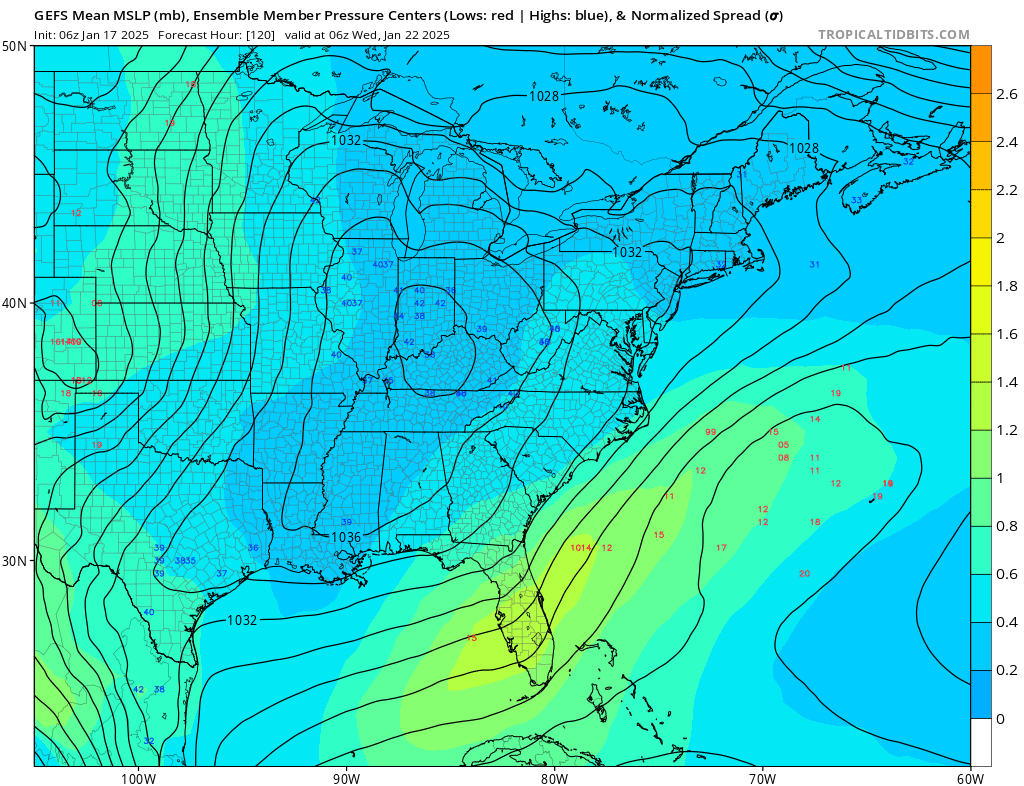
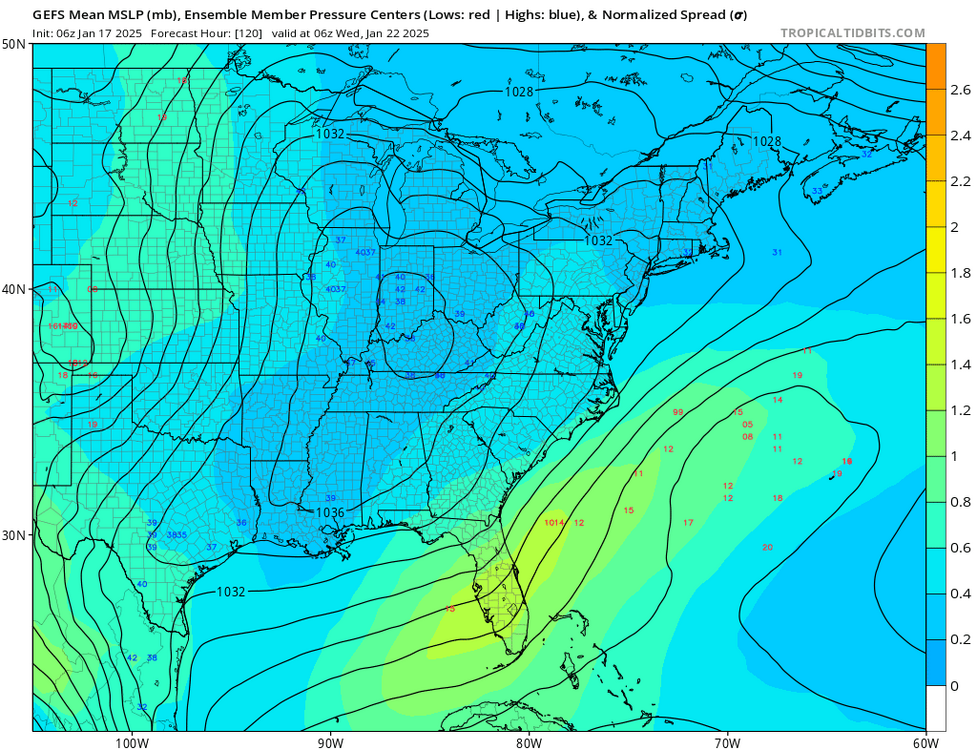
The Latest GEFS shows an increase in clustering of low pressure off the mid Atlantic coast during the 24th timeframe as compare with previous runs of the GEFS. This could be pointing to a trend that will eventually lead to a cutter/ inland runner (like the op). This would make sense given the fact that there is no block in place during that time period.. or it could be on to a big coastal low. Or it could just mean nothing. Two days ago we were talking about the 20-22 window.. now it is out another 10 days.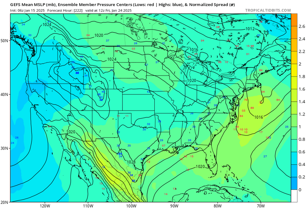
-
January Medium/Long Range: A snowy January ahead?
MDScienceTeacher replied to mappy's topic in Mid Atlantic
It made landfall!!?? -
January Medium/Long Range: A snowy January ahead?
MDScienceTeacher replied to mappy's topic in Mid Atlantic
There is a hurricane off the coast of California? -
January Medium/Long Range: A snowy January ahead?
MDScienceTeacher replied to mappy's topic in Mid Atlantic
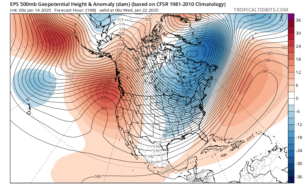
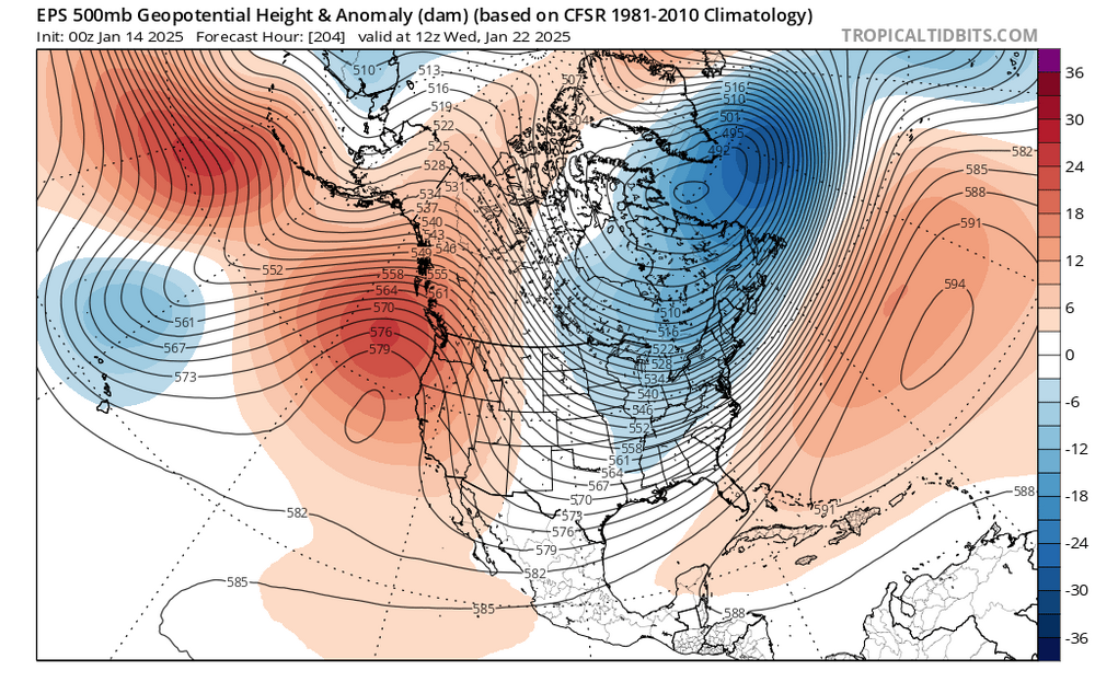
Haha.. I drafted and then deleted almost the exact post this morning. . I wont be so shy next time. I also think the position of trough is important also WRT suppression vs Coastal Track. As depicted above, one would think that a coastal low is definitely favored over a southern/ suppressed track. However, if you go forward 2 days, the center of the trough moves east by a couple hundred miles and the isobars are more WSW - ENE oriented over our area. I think that is why dont see a storm on the Euro for the 22nd 00z and a southern track on the GFS .. but as you said, the overall synoptic pattern does not indicate suppression and there are chances the second wave comes north as we move closer to the event.
-
January Medium/Long Range: A snowy January ahead?
MDScienceTeacher replied to mappy's topic in Mid Atlantic
I am not sure if the upper air pattern at that time frame really supports that outcome. It definitely does not look like the last couple of weeks where we had a raging 50-50 low, eating away at storms as they approach our region. To my untrained eye the jet stream looks more sw to ne in its configuration over our region, which I would think would support a coastal low. Then again I am not the expert on these 500 MB Maps.. -
January Medium/Long Range: A snowy January ahead?
MDScienceTeacher replied to mappy's topic in Mid Atlantic
I cant really tell the difference btw the 2.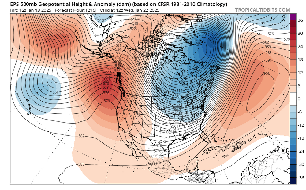
-
January Medium/Long Range: A snowy January ahead?
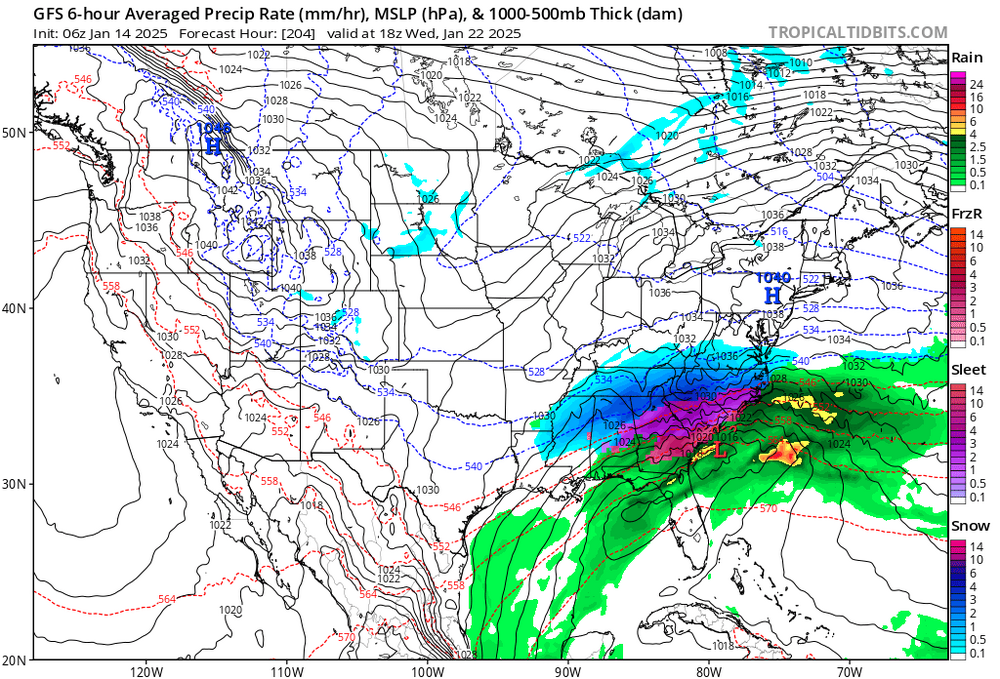
MDScienceTeacher replied to mappy's topic in Mid Atlantic
Big storm for the 22nd incoming.. again a little south at this timeframe, but I will take it