AtlanticWx
-
Posts
650 -
Joined
-
Last visited
Content Type
Profiles
Blogs
Forums
American Weather
Media Demo
Store
Gallery
Everything posted by AtlanticWx
-
Jan/Early Feb Medium/Long Range Discussion Part 3
AtlanticWx replied to WinterWxLuvr's topic in Mid Atlantic
my bad, i only saw his comment about march snow. and i agree, climo falls off a cliff in early march for any big storms -
Jan/Early Feb Medium/Long Range Discussion Part 3
AtlanticWx replied to WinterWxLuvr's topic in Mid Atlantic
we get march snow quite often. march 16 2022 dropped 4-6" across the NW metro thru an anafrontal and i know we got like 2" in march 2019 -
Jan/Early Feb Medium/Long Range Discussion Part 3
AtlanticWx replied to WinterWxLuvr's topic in Mid Atlantic
i think the look for jan 30 is pretty nice for a minor event here maybe, but mostly a new england setup tbh. the preceding airmass is so frigid though so i don't think this overextension will be as bad as the last where we went from an already warm airmass to even more warm this winter is shaping up to be great imo -
Jan/Early Feb Medium/Long Range Discussion Part 3
AtlanticWx replied to WinterWxLuvr's topic in Mid Atlantic
-
Jan/Early Feb Medium/Long Range Discussion Part 3
AtlanticWx replied to WinterWxLuvr's topic in Mid Atlantic
imo our next window is feb 15-march 15 based off weeklies & adjusting it for the probable fact that it gets can kicked a bit though. -
widespread 10-12" for the entire week across moco & hoco. what a run lmfao i did not expect this — i guess that's what ample cold and blocking does
-
7.5" here! I had the same totals as my friends in Gaithersburg & Clarksburg before hand, but we really lucked out with the squalls here. Picked up like 1.5" with the squalls, we really lucked out here lmfao
-
6.9" here! was around the same as most in moco prior to the squalls but i really got lucky with them. might push 7" or even 7.5" with the last squall heading towards me
-
0.5" after the squall in 30 minutes, and i wasn't even the brunt of it! 1-2" per hour rates in that fs
-
6.1" here in Germantown with moderate snow from the squalls
-
i got 2.4" in jan 3 2022 and 5.5" in jan 7 2022. haven't had a 6"+ event in a while so
-
5.1" now with 0.6-0.8" per hour rates right now. it's rippinggg
-
really coming down in gtown again
-
4.5" of snow in Germantown. 0.3" of snow in the past 30 minutes
-
4" in germantown! 3.95" to be exact
-
i think this is also bc it came in faster but modeled, but yeah this WAA thump was sm heftier than predicted lmao. never was predicted to come close to 1.25" per hour rates
-
it's awesome here! 3.6" of snow and 0.55" of new snow in the past 30 min)
-
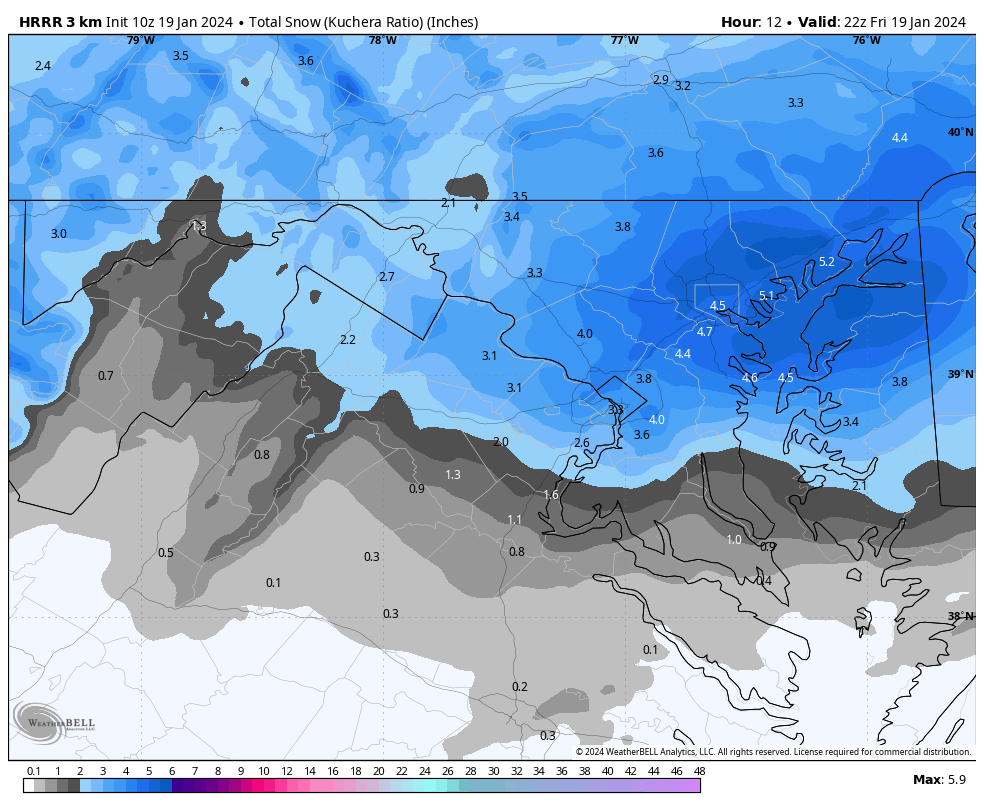
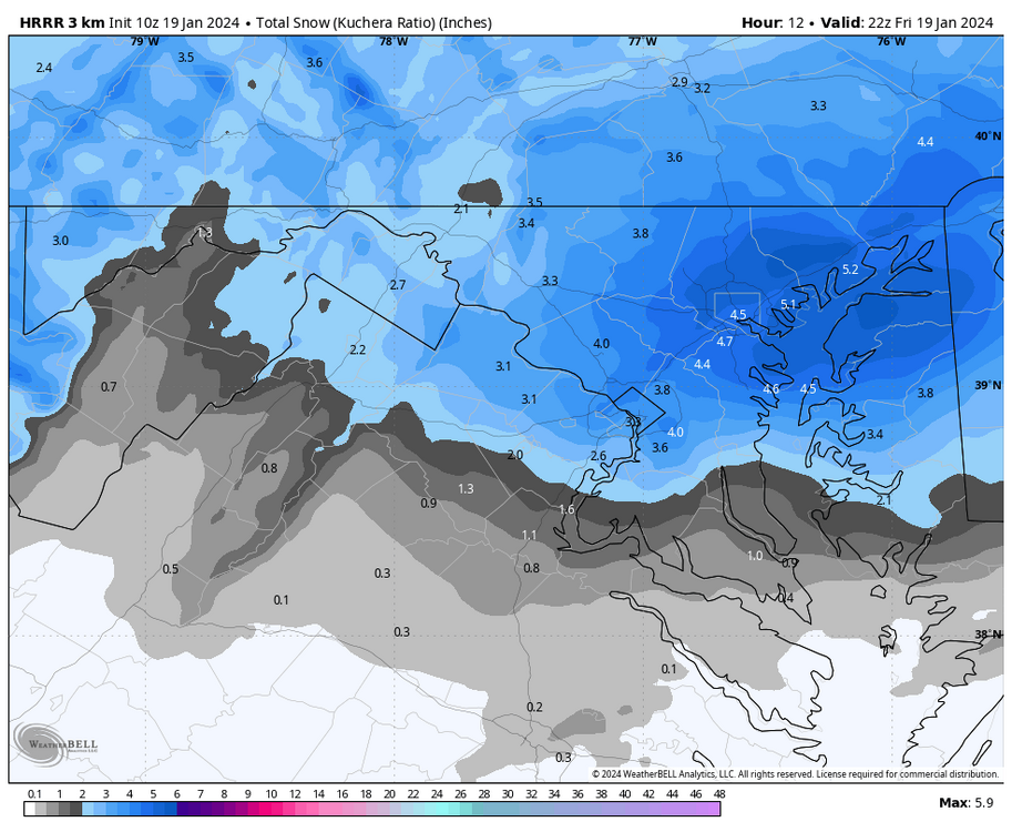
HRRR has a lot of moco pushing 6" including the 2-3" that's already fallen! personally i haven't gotten a 6"+ event since 2019 so this would be awesome
-
this is epic lmao
-
additional snow without the squalls ^ would subtract the additional snow from this map though because we've already seen this snow fall: 3" on top of the snow that has already fallen would be crazy tbh

-
HRRR still has 1-4" of additional snow for most of us. will post the map in a second
-
the radar keeps building back over moco lmfao, as soon as i think it's about to leave more greens appear.
-
3" in Germantown right now, with more left to go! Band is leaving though so we'll see
-
yeah most models had a WAA boom prior to the pivot. the bullish models especially (NAM 3K, HRRR). i think it's safe to say that this is overperforming, just surpassed the NWS forecast for me yesterday (2.8") probably with only the front end thump
-
some flakes reaching a width of an inch! really heavy stuff here in gtown w 30 dbz over us rn