-
Posts
675 -
Joined
-
Last visited
Content Type
Profiles
Blogs
Forums
American Weather
Media Demo
Store
Gallery
Posts posted by DarkSharkWX
-
-
-
The main event is Tuesday night to early am Wednesday right(if this system were to work out)?
-
-
-
2 minutes ago, Maestrobjwa said:
Warm neutral isn't gonna do much good...If we're already trending warmer, doesn't that make a case for a more established niño next winter?
yeah i think we'll get into some form of an El Nino.. hopefully moderate to strong
-
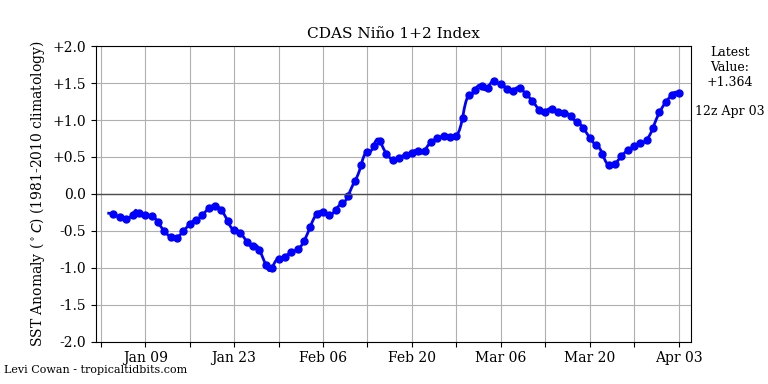
nino 1+2 has made it into positive territory and is continuing to rise
i think by next year we should at the very least be in a warm netural
-
 4
4
-
-
models are going to continue to mishandle the placement of the TPV until the short-early mid range, especially considering the lack of NATL blocking
-
euro also has some backend

-
 1
1
-
-
GFS will show another SECS/MECS in the next 2-3 runs
-
 3
3
-
-
-
5 minutes ago, AtlanticWx said:
actually, this pattern looks like a pattern that looks bad but could actually work. there's a very good cold source j north of us and even tho 500mb heights show a fairly weak SER 850mb temp anomalies and 2m temp anomalies are both BN
being on the thermal gradient should help us w/ overrunning storms too, we'll see. not a bad pattern in the peak of climo
yeah TPV sits over HB and brings down cold air down and potentially could bring the boundary south enough for a STJ wave to ride it and create an overrunning event. it's what we have been missing the whole year
-
 1
1
-
-
4 minutes ago, SnowenOutThere said:
It just keeps getting pushed back, first it was after the midweek cutter that things looked to improve and now its past February 5th.
the best chance for something wintry is still at the very end of the month - the start of Feb
-
 1
1
-
-
sadly we've trended away from an -NAO which was helping to push our boundary further south. cold rain tomorrow, maybe some front end slop on wednesday if we're lucky, and potentially something from the very end of jan to very early Feb before we torch and there's no hope for change until maybe late Feb-March if an SSWE happens and we get the downstream effects from it towards us 2-4 weeks later. even if we dont get a SSWE the SPV should still take a beating


-
-
6 minutes ago, jayyy said:
Nice little 3” event IMBY verbatim. Not bad for a storm that I thought had very little chance to produce much of anything. 4” lollipop about 15 miles west of me.
Would like to see the GFS move toward this tonight though. NAM being on an island 72 hours out isn’t the best place to be.
.1.5-2" for me - I think everyone NW of the fall line would be more than happy with that solution if it played out... sadly its the LR nam
-
 1
1
-
-
cutoff right at fall line verbatim lmao

-
9 minutes ago, TSSN+ said:
That’s nice. It was showing ridiculous numbers in December too. That worked out.
to be fair the december pattern that verified was different than what guidance was showing when that time period was in the long range, hopefully guidance holds on the looks we are seeing at 500h for the next 48h and if so confidence should be medium-high
also being in peak climo doesn't hurt much
-
 1
1
-
-
-
-
33 minutes ago, Maestrobjwa said:
Personally I think the GEFS and EPS are both improved in the 11-14 day range

Edit: I see I got a laughter emoji...so if I'm wrong please tell me, lol
you aren't wrong, EPS/GEFS shifted colder

-
 4
4
-
 1
1
-
-
-
8 minutes ago, CAPE said:
Has this dude always been a bit of a dick? Or is it just his 'victory lap' from the recent pathetic battle with the NE snow weenies?
the funny part is I think he used to root for us last year lmao, he has smth against northeast/ma people for no reason
-
this will prob be a backloaded winter esp if SSWE event advertised by LR models verifies
-
Isn't there some concerns with WAR and pna ridge being too far west?


.thumb.png.f20b361ff063dcef52ef1e3cf0353ee3.png)


.thumb.gif.3612e6ad25753a7f42f183d66e5487e9.gif)

Jan 31 - Feb 1 Snow/Sleet/Misery Obs & Disco
in Mid Atlantic
Posted
It had to cave eventually