

DarkSharkWX
-
Posts
675 -
Joined
-
Last visited
Content Type
Profiles
Blogs
Forums
American Weather
Media Demo
Store
Gallery
Posts posted by DarkSharkWX
-
-
2 minutes ago, 40/70 Benchmark said:
Anyone know why this IOD link isn't updating, and where the updated numbers are?
https://psl.noaa.gov/gcos_wgsp/Timeseries/Data/dmi.had.long.data
i'm pretty sure this is the one that evb uses, https://www.bom.gov.au/climate/enso/indices.shtml?bookmark=iod

-
 1
1
-
-
RONI should be <-0.5, global SSTA is near +0.5


-
2 hours ago, 40/70 Benchmark said:
2013-2014 also didn't have any higher end KU events if I am not mistaken....perhaps I am, not sure. But I know for my area, there were no really memorable events, which are tougher to achieve without a well placed PNA ridge. It's much easier to get more moderate snowfalls, which is mostly what we saw.
Anyway, like I said...no absolutes. You don't absolutely NEED the PNA to cooperate...you can still time everything perfectly, but it's just much tougher.
for me the highest storm in 2014 was the overpreforming vday storm with ~19" here, 20-26" in the ridges north of me
-
56 minutes ago, 40/70 Benchmark said:
Mentioned before, I am confident this will be BS this season. Will revisit next spring.
i mean we still probably will get a good period of HL blocking w/ -EPO and +PNA its just that theres going to be more SER (especially before/after good periods) with a more developed nina since -QBO relates to more active MJO
-
3 hours ago, snowman19 said:
This was mentioned extensively last fall….the research showing that +QBO/-ENSO causes a more poleward Aleutian High, while -QBO/-ENSO causes a more flattened, equatorial Aleutian Ridge. HM had a blog on this many years ago, which unfortunately I can’t find the link to anymore. IF this research is correct, then we will see it come “cold season” (Nov-Mar).
+QBO causes the tropical tropopause to stabilize which makes convection focus further off the equator which shifts the pattern more poleward, -QBO would have more active MJO(in general) but more focused on the equator
-
 2
2
-
-
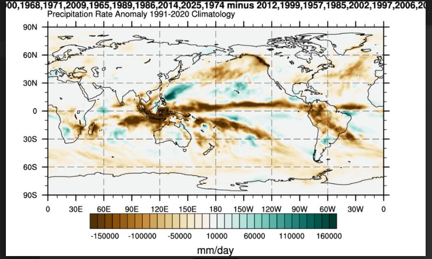
 is there any other alternative that allows you to change climo periods and parse an unlimited amount of years?
-
41 minutes ago, 40/70 Benchmark said:
I would describe it as rethinking the assumption that a parochial approach to seasonal forecasting will be good enough.....ENSO, and SSTs in general along with every other variable, needs to be contexualized relative to the rest of the globe, which is precisely what RONI attempts to do. Its not the SSTs themselves that are the primary drivers of the hemispheric pattern, but rather the gradients. This is why we need to view ENSO RELATIVE to the western Pacific, and within the context of tropical forecasting, SSTs RELATIVE to the subtropics. It doesn't matter how extreme ENSO is (warm/cold) if the western Pacific is every bit as anomalous. Likewise, bathwater SSTs in and of themselves are not conducive if the subtropics are even more anomalously warm because the atmosphere will lack the requsite instability and CAPE to foster adequate convection.
This season is a wonderful lesson in how to engage in tropical forecasting on a seasonal level in a warming climate just as the El Nino of 2023-2024 was very instructive with respect to mid latitude seasonal forecasting.
there was actually a recent research paper that came out that attributed the lack of extreme teleconnections in the 2023/24 strong/super nino to an equally, if not more anomalous warming in the tropical Indian and Atlantic oceans, which is certainly interesting to think about how this will affect how seasonal forecasts are conducted in the future
https://www.nature.com/articles/s43247-025-02584-8
-
4
-
-
nam vs euro, all abt the tilt
.thumb.gif.ce8dd8d79c32c5cefdf62b5ef4fce003.gif)
-
1 minute ago, DarkSharkWX said:
i was talking to cody snell yesterday(WPC met) and he said similar things relating to the CIPS analogs being further north. he implied that he was expecting a northern trend(not a huge jump to the NW though) but he said to expect some southern shifts in the next forecast cycles. as you've said multiple times it seems a bit odd that this is so suppressed with a UL strength like that tracking relatively north

speaking of i think this is an expansion north a bit lmao(the cyan anyways) -
2 minutes ago, frd said:
How much time do we have left for a significant change to more robust storm solution?
modeling is atrocious with TPV setups and ULLs but maybe until tmrw night? id greatly lower expectations though ofc
-
2
-
-
2 minutes ago, psuhoffman said:
Honestly they both look like we should be worried about a too far NW track not a coastal scraper. I’ve honestly never need so “confused” by model output. I rarely ever see something I’ve never seen before but this is if.
A closed h5 low near Chicago and a h7 pass through PA = big snow to our southeast? Not in any book I’ve ever read.
i was talking to cody snell yesterday(WPC met) and he said similar things relating to the CIPS analogs being further north. he implied that he was expecting a northern trend(not a huge jump to the NW though) but he said to expect some southern shifts in the next forecast cycles. as you've said multiple times it seems a bit odd that this is so suppressed with a UL strength like that tracking relatively north
-
3
-
1
-
-
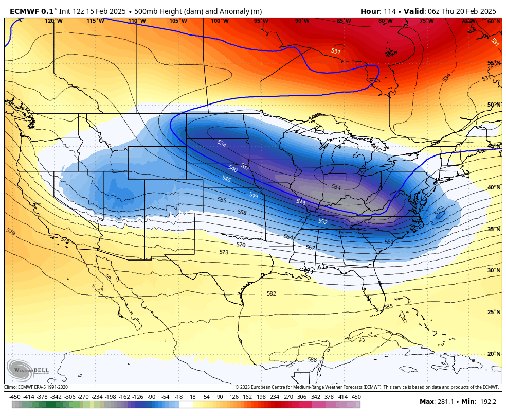
Although the Euro has been trending better in some aspects(a more amped upper low, kicker more held back -> more +PNA), the problem here is the tilt. It has been trending more neutrally tilted which is a problem, additionally, the flow out ahead of the TPV lobe is more suppressive, and the southern stream shortwave isn't digging as much, leading to a more OTS solution. Ideally you'd want to see the confluence lift up a bit with the SS digging more for a less flat flow. We'll need an earlier, more robust phase with less flat flow. Looking at old runs that were good for us, the +PNA was good but the key difference was that the trough was more buckled since the SS wave was able to dig more leading to a more negative tilt. The TPV wasn't squashing out the flow in front of it because of this, so now in future runs we'd want to see a relax of more confluence and more buckling of the trough via the SS wave being deeper, and maybe slow down a little bit to raise heights out east and turn the trough negative.
I don't think the +PNA is the issue here on its own; its a phenomenal change, its the fact that there's other changes which are bad vis a vis the SS wave which makes the flow out ahead of the TPV lobe worse, so that's why despite the Pacific "improving", surface is considerably worse.

-
4
-
1
-
-
v day 2007, but also some of the higher end 80s storms-
1
-
-

WOAH-
4
-
 1
1
-
-
-
-
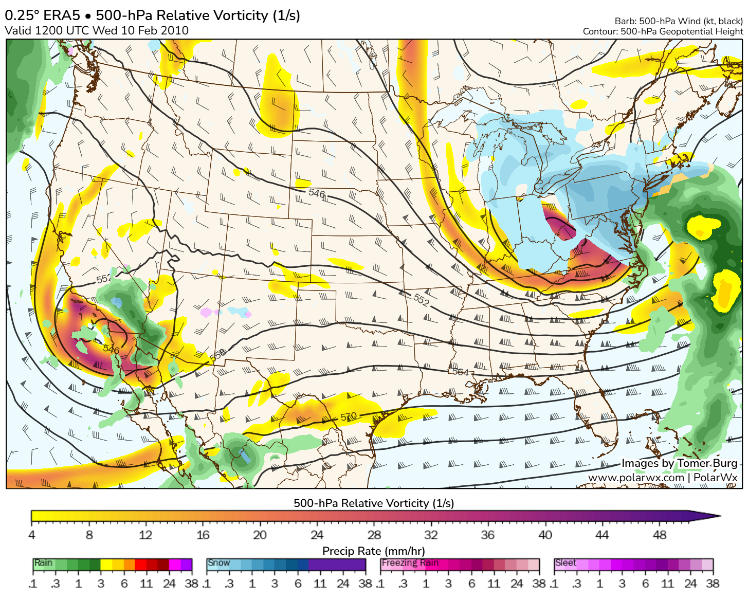
5 hours ago, Heisy said:
The second event feb 9-11 2010 was sort of like that. This event has more southern proponent ahead of it I think
.thanks for the suggestion, looking at era5 looks like it did have a tpv phase - kicker vort dug and amplified the western ridge which lead to a tpv lobe digging all the way down and phasing w/ the other wave, roll it forward and...


-
4
-
-
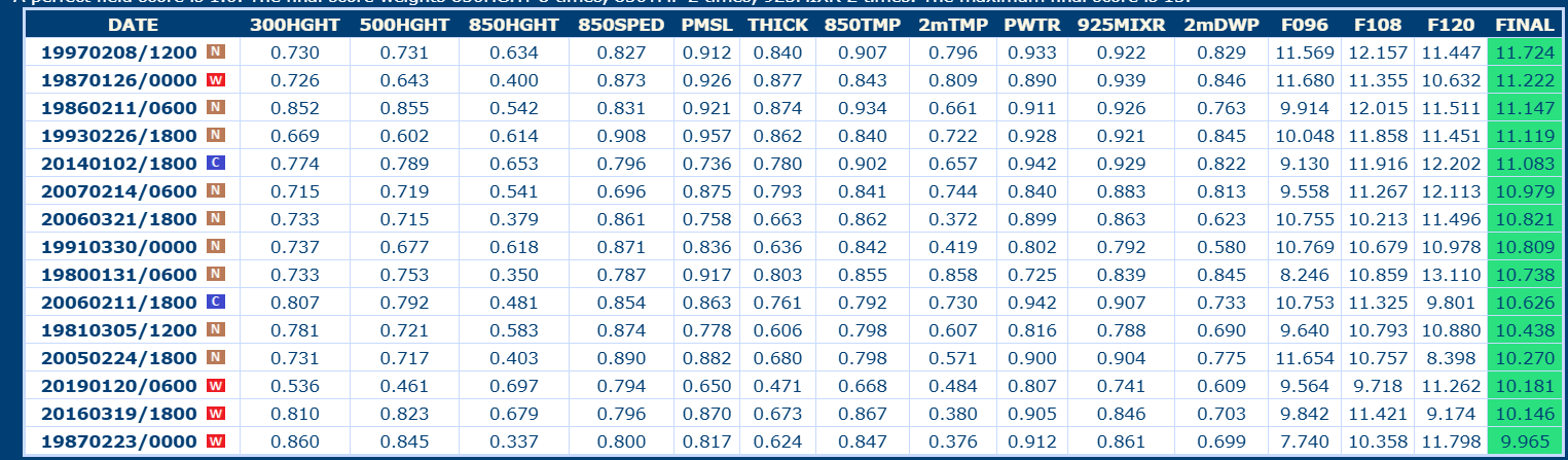
genuine question, what was a similar storm to this setup with TPV interaction(to this extent) being involved?
-

this is quite nice-
3
-
-
-
10
-
-
2 hours ago, WxUSAF said:
AI buries us apparently? Where you at @mitchnick?
On a different note, keep in mind this deamplification trend may be starting for the Thursday and weekend storms next week already…
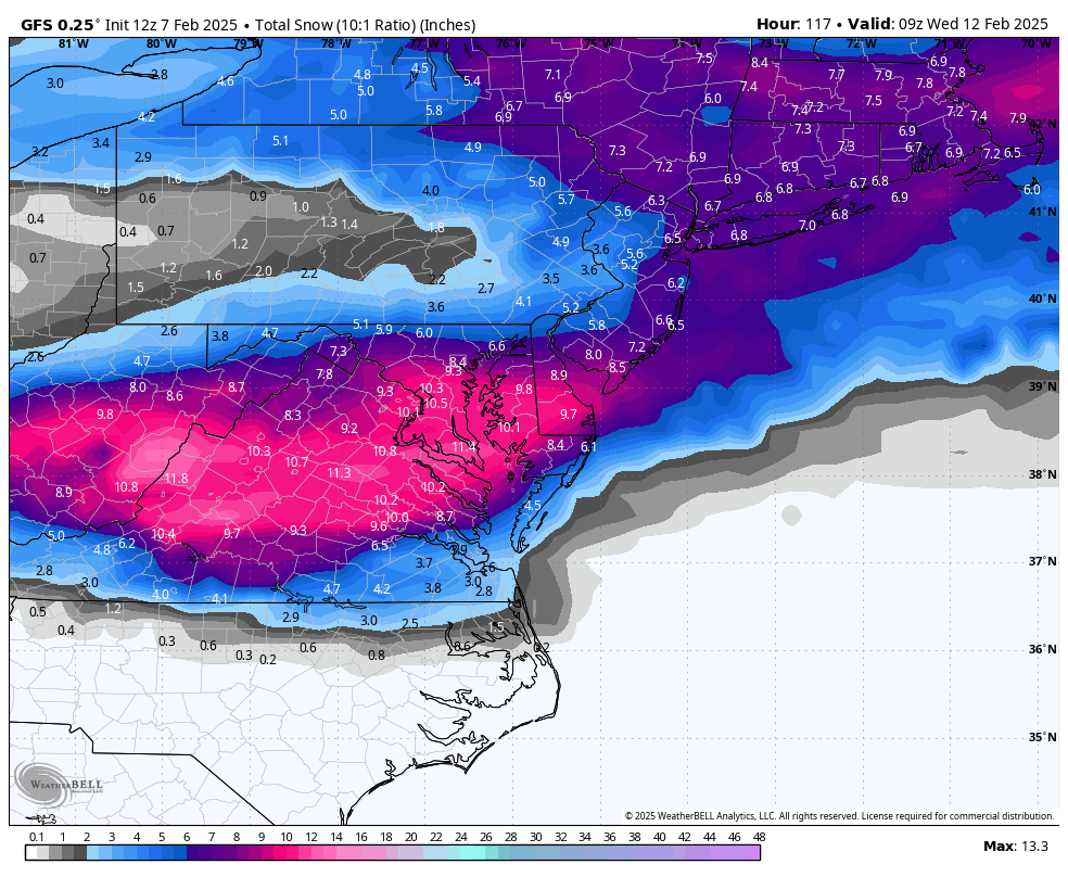
idk if i should post the map here... might as well lol


-
2
-
 5
5
-
-
-
6
-
1
-
 1
1
-
 2
2
-
 2
2
-
 1
1
-
-
just checked soundings for JYO/GAI we don't mix until hour 126 when precip is all out and even if there was precip its just sleet
-
1
-
-
Just now, Ji said:
What made euro change to ice
honestly idk 850s are below the entire time we get precip, even if there is a warm nose its probably like sleet not zr
.gif.e5ef3b60368acaf298af93c59db68f0a.gif)


2025-2026 ENSO
in Weather Forecasting and Discussion
Posted
decent amount of bob warming recently