

DarkSharkWX
-
Posts
675 -
Joined
-
Last visited
Content Type
Profiles
Blogs
Forums
American Weather
Media Demo
Store
Gallery
Posts posted by DarkSharkWX
-
-
17 minutes ago, DarkSharkWX said:
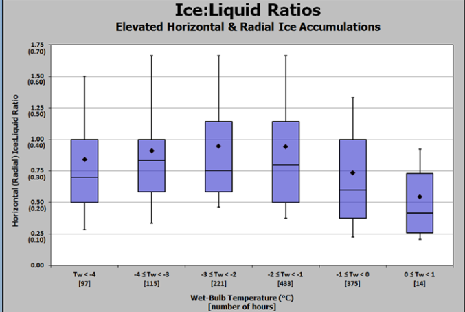
The best conditions for optimal ice accretion are greater wind speeds(takes away hear from surfaces and advects cooler air), small droplets falling through a shallow melting layer, lower wetbulb temperatures, and lighter precipitation rates(heavier precipitation rates lead to more runoff and less efficient accretion).
This is what a study found about precipitation rate, wind speed, wetbulb temperatures, and how they correlated to ILR. Freezing rain can occur even with temperatures above freezing, but if the wetbulb temperature is above freezing, freezing rain can't occur. The study generally found that wetbulb temperatures between 27-30F, greater windspeeds, and lighter precipitation rates all contribute to more efficient ice accretion.
Here is the link if anyone is interested in it:

-
 4
4
-
-
The best conditions for optimal ice accretion are greater wind speeds(takes away hear from surfaces and advects cooler air), small droplets falling through a shallow melting layer, lower wetbulb temperatures, and lighter precipitation rates(heavier precipitation rates lead to more runoff and less efficient accretion).
-
3
-
 1
1
-
-
FWIW, GFS has a better run with lower heights over eastern 1/3 of US, less seperation between departing 50/50 and the ULL, and more confluence(heights over Canada further south). This all helps bring a better CAD signature and a further south ULL.
.thumb.gif.67e4fae5d5ada3f9c0d0587387f4e50c.gif)

-
6
-
-
RGEM has a further west TPV and weaker ridging over Ohio Valley/Eastern 1/3 of US(based on looking at vorticity and isobars). This is likely why we saw a colder solution this run, with colder temps at SFC and 925mb. We did however have warmer 850mb temps. We will know more tomorrow as mesoscale models get into their better ranges and more things get sorted out.


-
4
-
4
-
-
GFS has the ULL negatilt earlier this run with a further west TPV and more western ridging leading to a colder solution(SFC ptype map just used to show that GFS has colder solution)


-
4
-
-
With all favorable teleconnections(-EPO/-NAO/-AO/+PNA), we don't have to worry about getting good cold air. However, this pattern will also be active in terms of storms. The -EPO will deliver polar flow and allow cold air to flood into the CONUS as well as bring strong NS shortwaves into the US. This is evident on the 250mb wind maps where we see an active northern stream. With an active STJ(as shown on 250mb wind maps), providing southern stream shortwaves, the northern stream shortwaves dive down and potentially phase with the southern stream shortwaves, which could bring large storms along with the cold air.


-
13
-
1
-
-
GFS slightly better this run with what appears to be a further west TPV, less weakness in the heights over Canada, and weaker ridging over Great Lakes/OH Valley.

-
2
-
-
This Euro run we saw more separation and less interaction with ULL and PAC trough. This lead to more western ridging building in earlier, and also means that the ULL doesn't negatilt early enough, and stays positive tilt for longer which isn't good. Additionally, the TPV seemed more east this run. Now we want more PAC trough interaction with ULL so that it negatilts faster, but not so much that it gets sheared out.
-
1
-
-
GEFS has been trending with a stronger CAD push for the 16th-17th storm. Encouraging trends to see

-
2
-
-
One reason today's afternoon EPS was worse than 0z is due to the placement and strength of the Aleutian low. Comparing 12z to 0z, we see that the Aleutian low in 12z is weaker and further west. A stronger + further east Aleutian low allows for a more poleward western ridge to setup, and along with the -EPO and -NAO/-AO, allows for cold to press on the EC and gives us the great look.
Note: The 12z EPS today is certainly not bad at all, and is still a good look, just not as good as previous runs and not the "textbook" setup.

-
4
-
1
-
-
12z EPS looks worse with more troughing in the west. Everything else looks fine(NAO, EPO).


-
1
-
-
4 minutes ago, AtlanticWx said:
Wow.

Literally textbook...
We have -EPO to provide cold air and northern stream shortwaves, troughing over and east of HI to indicate southern stream shortwaves/active STJ, western ridging, troughing over EC, and of course the -AO and west based -NAO.-
4
-
-
Lmao CMC op has a triple phaser storm at the end of its run

-
1
-
 4
4
-
-
EPS/GEPS look good


-
1
-
1
-
1
-
-
-
6 minutes ago, wxmvpete said:
It can be vary from run to run given the ensembles involved, but it does give at least an early glimpse for some areas to keep an eye on in the days to come.
(My first post. How about that!)
Welcome!
-
1
-
-
We can work with a slightly negative/netural PNA with all the blocking/alaskan ridging we have
-
1
-
-
EPS has had the TPV trend more northwest in its position which allows for stronger SE ridge to take place at least initially before it breaks down as the block retrogrades towards the Baffin Bay. Doubt this would mean/affect anything, but maybe we hold onto the SER for a bit longer before it gets suppressed. Pattern still looks really good after block enters Baffin Bay, and we won't really have to worry about that. Just some food for thought, still going to enter a great pattern soon
.thumb.gif.4d84eee56601549f9bd539458f6dd6e8.gif)
-
4
-
-
Troughing east of Hawaii(which means increased southern stream interaction), ridge axis over Idaho, WB -NAO over Baffin Bay. Can't really ask for much more. Beautiful look for us

-
11
-
1
-
-
12z EPS compared to pattern right before Boxing Day Storm in 2010. EPS if anything looks better with more favorable Pacific. While we got missed out on 2010, the pattern was great, we just got unlucky with the storms. EPS has been really consistent with pattern unlike GEFS who we are seeing make moves towards GEFS with better trends in Pacific. Pattern seems to favor us really well, hopefully the big storm we've been waiting for comes soon. That block in Arctic will do us wonders with cold air

-
9
-
.gif.91bba2994e4dfe68742834938f4569e6.gif)


.gif.dae98b2e5a8c005616da8683101bcc02.gif)

December 15-16 Mixed Bag of Precip
in Mid Atlantic
Posted
Think everyone in advisory will close/go virtual or at the very least delay