

DarkSharkWX
-
Posts
539 -
Joined
-
Last visited
Content Type
Profiles
Blogs
Forums
American Weather
Media Demo
Store
Gallery
Posts posted by DarkSharkWX
-
-
even waldorf switches over this run-
 1
1
-
-

23z hrrr data had 2 dropsondes into it, 0z runs will have the full source of data-
8
-
-


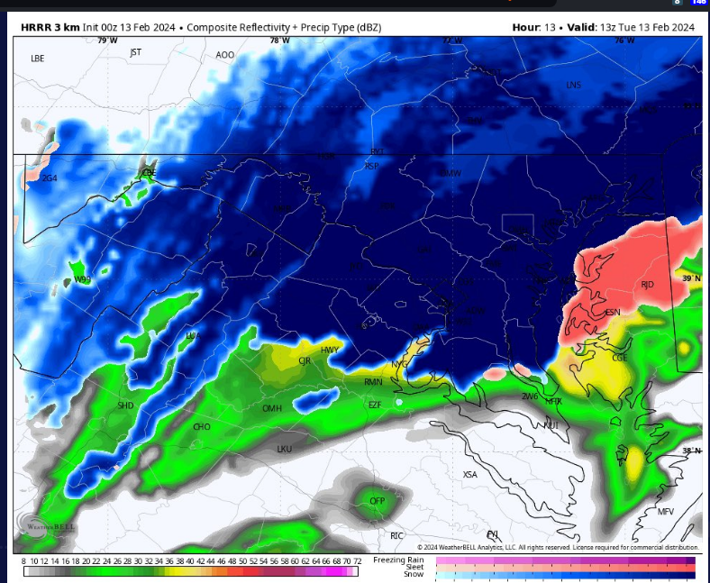
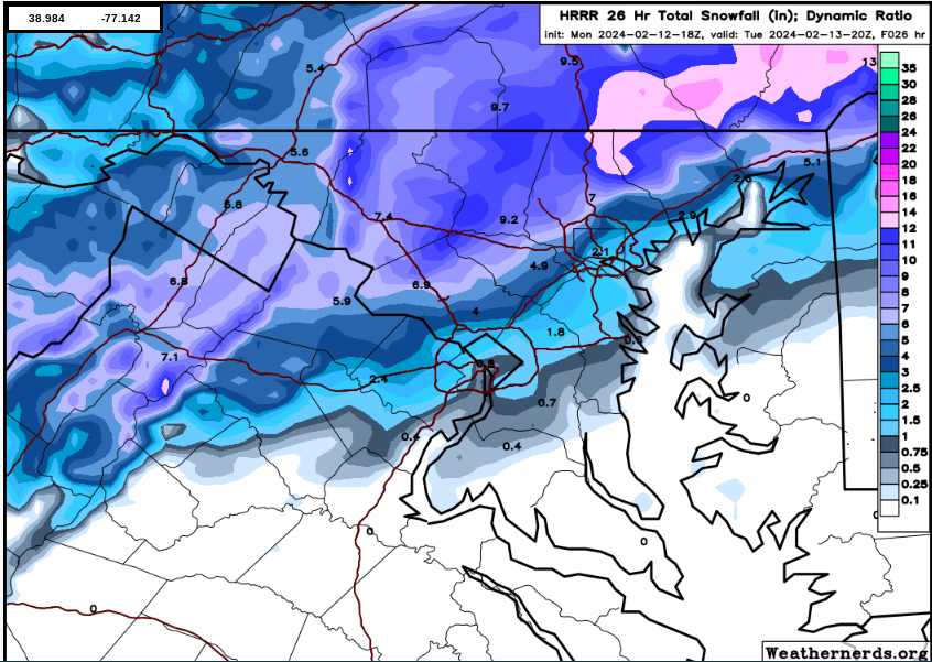
this storm is gonna be dependent on rates, if we get them accumulation concerns are minimal even with marginal sfc temps-
2
-
-


this as advertised would be insane on the hrrr, no problem sticking with those rates and dynamic cooling-
2
-
-
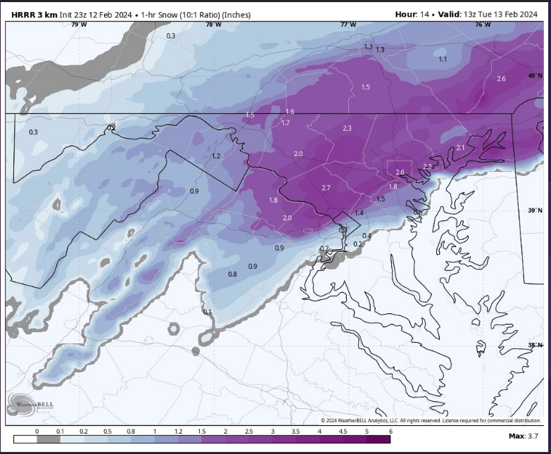
 soudning in N moco, this would do it
-
4
-
-
-
-
 there we go
-
4
-
-
2 hours ago, psuhoffman said:
I agree with a lot of this. But why did you expect a +pna in a -PDO Nino? There have been 4 Moderate/strong -PDO Ninos. None featured a +pna. Mean for the 4 is below.

3 of the 4 were some of the snowiest winters in history here including 2010! The one exception was 1973 which was a +QBO and has a crazy +++AO
So if we agree that was an outlier and toss all 3 examples of a -pdo moderate or stronger Nino featured both a -pna and a shit ton of snow.
Actually if you simply take all moderate to strong ninos the mean is a -pna. It’s only weak modoki ninos like 2003 and 2015 that feature a +pna. But Baltimore averages 40” of snow in -QBO ninos despite the fact the pna is typically negative.
I never expected a +pna this winter. My analogs that produced a mean snow of 42” were -PNA city. There is something else going on. It’s not the pna because the pna was negative in past epic snowy ninos.
this is very interesting, especially 1964
but to be fair though the block is defintely weaker than previously modeled, and the pac has gotten worse tooi wish there was a way to properly compare the 500h archive maps on psl to what models have right now; do you still think the pattern is good and can produce considering the downtrends we've been seeing?
-
like the trend for more western ridging
-
1
-
-

barely have made it to phase 8 -
-
-
tbf since the block is weaker than previously thought we're probably going to want to root for a slightly better pac
-
2
-
-
worth noting that the pattern downgraded because of the NPAC jet extending a bit too far, not to mention the 14th storm not being a cutter and kickstarting the -NAO earlier
still looks good but is def worse than compared to how it was looking earlier

-
great changes, tpv looks a lot better this run too
.gif.24d5ac9999fdf66c5b48b9ac5ddabd09.gif)
-
7
-
-
for anyone who cares GEFS def improved w the blocking this run

-
3
-
-
2 minutes ago, CAPE said:
This is a good look on the EPS with significant NS energy tracking eastward and phasing into the 50-50 low ahead of the southern shortwave. The tricky part will be the next piece of energy dropping southward as the wave continues to track east.

overall good changes, better chance of phasing and brings the vortex more E

-
1 minute ago, Ji said:
No but I’ve seen many storms like the gfs shows modeled rain a week out in a good pattern end up as snowi remember the sne storm in 2022 was modeled rain for them
wasnt 2016 modeled as rain far out? -
15 minutes ago, Ji said:
Where is the mjo actually?

look at hovmollers

-
-
-
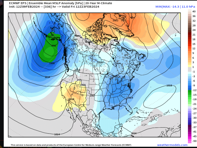
goa low on EPS for the 24th signal, jet is extended right amount and in good spot(this usually js comes with +EPO), pacific troughing/goa low is correlated to snow for us bc it implies enhanced STJ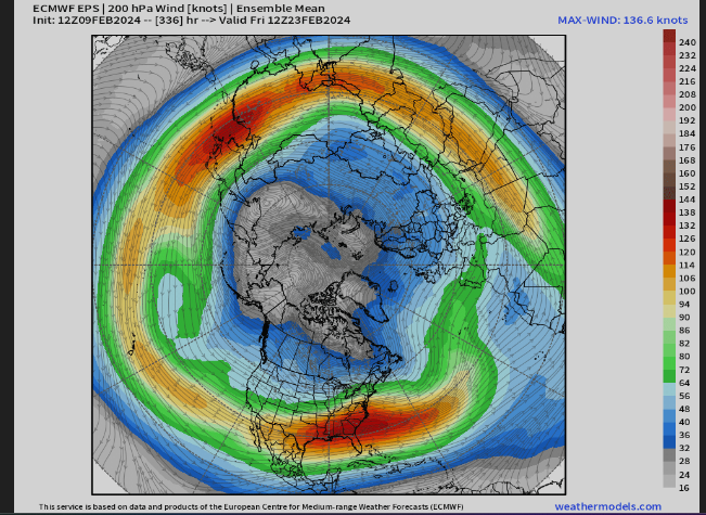
as others have said it looks good for 24th-
3
-
-
5 minutes ago, nj2va said:
Looks great!

i mean it did its js a weak ass strung out wave


2024 Valentines Day Who the Hell Knows - Comeback Thread
in Mid Atlantic
Posted