RU848789
-
Posts
3,989 -
Joined
-
Last visited
Content Type
Profiles
Blogs
Forums
American Weather
Media Demo
Store
Gallery
Everything posted by RU848789
-
If we were 36-48 hours out, I'd be watching TV, lol, but we're still 84 hours out when modest to even significant changes are possible. Not that I'm counting on them, but that's the state of NWP at this time, even with improved models.
- 993 replies
-
- 2
-

-
- metsfan vs snowman
- bomb
- (and 2 more)
-
NAM actually has heavier precip in our area and just west of here near the end of its run than the 18Z Euro or 0Z GFS do. I know it's the NAM at 78-84 hours, but it's something. Maybe.
-
Figured most level-headed posters here would see this, which is why I shared the NWS post/graphic earlier today. I actually saw it first on a Rutgers sports board where I post weather info by a guy who posts all kinds of nutty conspiracy crap, so I then went to the NWS-Philly FB page to see if it was real and it was and then I posted that I thought it was irresponsible. The response was mostly derision, although 30 min later someone took the ridiculous graphic down. I simply don't think scientific personnel responsible for public safety should be posting misleading crap - no issue with humor, but figure out a way to do that without compromising the science.
- 993 replies
-
- 4
-
-

-

-
- metsfan vs snowman
- bomb
- (and 2 more)
-
The 40" post was 100% real on the NWS-Philly FB page. I said it was irresponsible on the page and some agreed and others thought I was being silly, but public safety isn't a joking matter IMO (and if they had clearly include smileys or a comment making clear it was a joke I wouldn't have cared, but they didn't). They have since pulled the graphic from the FB page (you can even see that it was edited to remove a graphic), but kept the text there, which was fine. https://www.facebook.com/NWSMountHolly/posts/pfbid0zJeNRScVzhfRH1f6CD46octVXdtw865K7EQpwCF7S3PTLumC4wxag5sC7xpMia3el?comment_id=1113426140241143&reply_comment_id=1250860806202090¬if_id=1736278761590820¬if_t=comment_mention&ref=notif
- 993 replies
-
- 1
-

-
- metsfan vs snowman
- bomb
- (and 2 more)
-
Dan Zarrow is decent for the NJ area and after the 12Z models came out he has a 20% chance of a bomb (6-24"), a 60% chance of light snow (1-4") and a 20% chance of nada (which is almost exactly what I said earlier). The NWS was also much more bullish on a light to moderate event than they were this morning, as per today's 4 pm discussion. But unless 0Z moves back towards 12Z, my guess is most will, rightly, back down a bit on snowfall forecasts/likelihood for our area based on 18Z and a perhaps similar to 18Z suite at 0Z and we might then be in the same boat we were in for this past event for areas N of 276/195, i.e., hoping for 1-2" of snow at best. Might happen. https://nj1015.com/nj-stays-frozen-and-windy-3-possible-scenarios-for-weekend-storm/
-
Over the top statement almost 4 days out. Getting a minor to moderate snowfall is certainly still possible - we're still even outside the range of the NAM/RGEM and we've seen major changes from this point to an event many times in the past. At about this same point for the 1/6 storm, i.e., 18Z on Thursday about 90 hours before the start of precip, we were celebrating the moves north of the GFS, Euro and ICON which along with decent snows for the CMC/UK made it look like we could get 2-4/3-5" for CNJ/NNJ/NYC. We all know how that went south fairly quickly with 0Z showing big moves south by the UK/Euro and they really never wavered much from having maybe an inch for our area until the storm, while the other models slowly moved towards them somewhat. The point being that modest to significant changes can still occur and I don't think anyone can predict with high confidence whether those moves will occur this time and if they do, what direction.
- 993 replies
-
- 4
-
-
-
- metsfan vs snowman
- bomb
- (and 2 more)
-
Liked this... https://x.com/MikeMasco/status/1876718043654697202 https://x.com/i/status/1876718043654697202
-
They deleted the graphic from their FB post, because I'm sure someone in the NWS kicked someone's butt over the irresponsibility of posting a graphic showing "0-40" of snow possible."
- 993 replies
-
- 1
-

-
- metsfan vs snowman
- bomb
- (and 2 more)
-
This is real from the NWS and not a joke. Told them I thought the 40" part in the graphic was irresponsible. The text in the post was fine... "We've been getting a lot of questions about the potential weekend winter storm. To answer those questions, there is about a 50-60% chance of snow. That's all we know. We do NOT know how much snow we'll be getting yet. The storm is still 4 days away, and a lot can change. Could we get significant amounts? Sure, but there's still a chance we end up getting insignificant amounts. Greatest threat is Friday night and Saturday morning. Keep an eye on the forecast in the coming days for more information!" https://www.facebook.com/NWSMountHolly/posts/pfbid0zJeNRScVzhfRH1f6CD46octVXdtw865K7EQpwCF7S3PTLumC4wxag5sC7xpMia3el
- 993 replies
-
- 7
-
-
-
- metsfan vs snowman
- bomb
- (and 2 more)
-
Was great to see the 12Z Euro making a major move towards the GFS aloft and a smaller one at the surface, which should give folks more confidence in at least a minor to maybe moderate event. I think the NBM looks like a good estimate at this point (unlike for the last storm 4 days out, where I think the time lag/precip issues were more noticeable).
- 993 replies
-
- 1
-
-
- metsfan vs snowman
- bomb
- (and 2 more)
-
You need to read my post more closely - I said "at least 1-2/2-4" for the DC-Boston megalopolis or not that far SE of there" with the 12ZGFS/6ZEuro/12ZICON showing that for the megalopolis along 95 and the 12ZCMC showing that about 50-75 miles SE of 95 (i.e., mostly off-shore, but still "not that far SE of there").
-
Almost every model is showing at least 1-2/2-4" for the DC-Boston megalopolis or not that far SE of there meaning a minor (1-2") to moderate (2-4") event is not the almost pipe dream that a bomb is and most of us would be happy with a few more inches of snow. I'm loving looking out my window right now at 1.2" of snow, which should mostly still be there come Saturday.
- 993 replies
-
- 2
-
-
- metsfan vs snowman
- bomb
- (and 2 more)
-
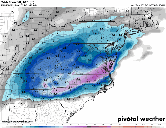
12Z ICON looks similar to 6Z giving our area a general 1-3" snowfall on the northern fringe of the snow shield, with more for the mid-Atlantic. Totally different setup, though, with a Miller A vs. the SWFE we had yesterday, so more room for positive/negative changes, IMO. Would gladly take another 1-3" though. The 12Z NAM looked quite similar to the ICON at 84 hours, at least at the surface - and to me all of the models look pretty similar at the surface through 0Z Saturday with the low on the FL Panhandle and then they diverge.
- 993 replies
-
- 2
-
-
- metsfan vs snowman
- bomb
- (and 2 more)
-
Don't know if you or others would know the answer to this, but has anyone ever gone back and run some big storms with very checkered modeling history, like 12/26/2010 (which looked dead 36 hours before the event and then boom! as most around here would know), using today's models, which we know are more accurate, in general, to see if they would've done better than the 2010 models did? I know the model improvements over the years are not all due to the physical models themselves, but are also due to the improvements in the richness of the data inputs, so today's models with 2010 or 1980 data inputs might not be as good, but I would love to know the answer to how today's models would do vs. older models for storms of the past.
- 993 replies
-
- 2
-
-
- metsfan vs snowman
- bomb
- (and 2 more)
-
To summarize, at 0Z, GFS is a significant snowstorm for most of our area, especially the coast, while the Euro gives an inch or two towards the coast, but is essentially out to sea again (similar to the past few runs) and the CMC and UK are also out to sea well to our SE, with all four models giving decent snowfalls to the deep south then some to SC/NC/SoVA before heading up the coast (GFS) or out to sea (Euro, CMC, UK); the ICON does give our area a few inches. This system is on life support for being a major snowstorm for our area, kind of like RU's hoops season, lol. In both cases, it's not over yet, but if we don't see dramatic changes soon, they're toast. And the 6Z GFS is similar to 0Z with the Euro to come. Great analysis of what's going on meteorologically by Tomer Burg, below, including why this system is much more complex and unpredictable 5 days out than today's storm was. https://x.com/burgwx/status/1876453467453083696
- 993 replies
-
- 2
-
-
- metsfan vs snowman
- bomb
- (and 2 more)
-
I'd be very happy with a less amped storm that still dumped 4-8" of snow on most of the area...
- 993 replies
-
- 1
-
-
- metsfan vs snowman
- bomb
- (and 2 more)
-
Looking good so far...
-
Snowfall NYC subforum Jan 6 and OBS if needed
RU848789 replied to wdrag's topic in New York City Metro
Bummer for the SEPA/SNJ folks near Philly, who got a lot less than forecast and not much more than most of us in CNJ and even NNJ. -
1/6 snowstorm - nuisance event or something bigger?
RU848789 replied to LVblizzard's topic in Philadelphia Region
Damn, thought you guys would get more - sounds like Philly and adjacent SNJ only getting 2" or so... -
1/6 snowstorm - nuisance event or something bigger?
RU848789 replied to LVblizzard's topic in Philadelphia Region
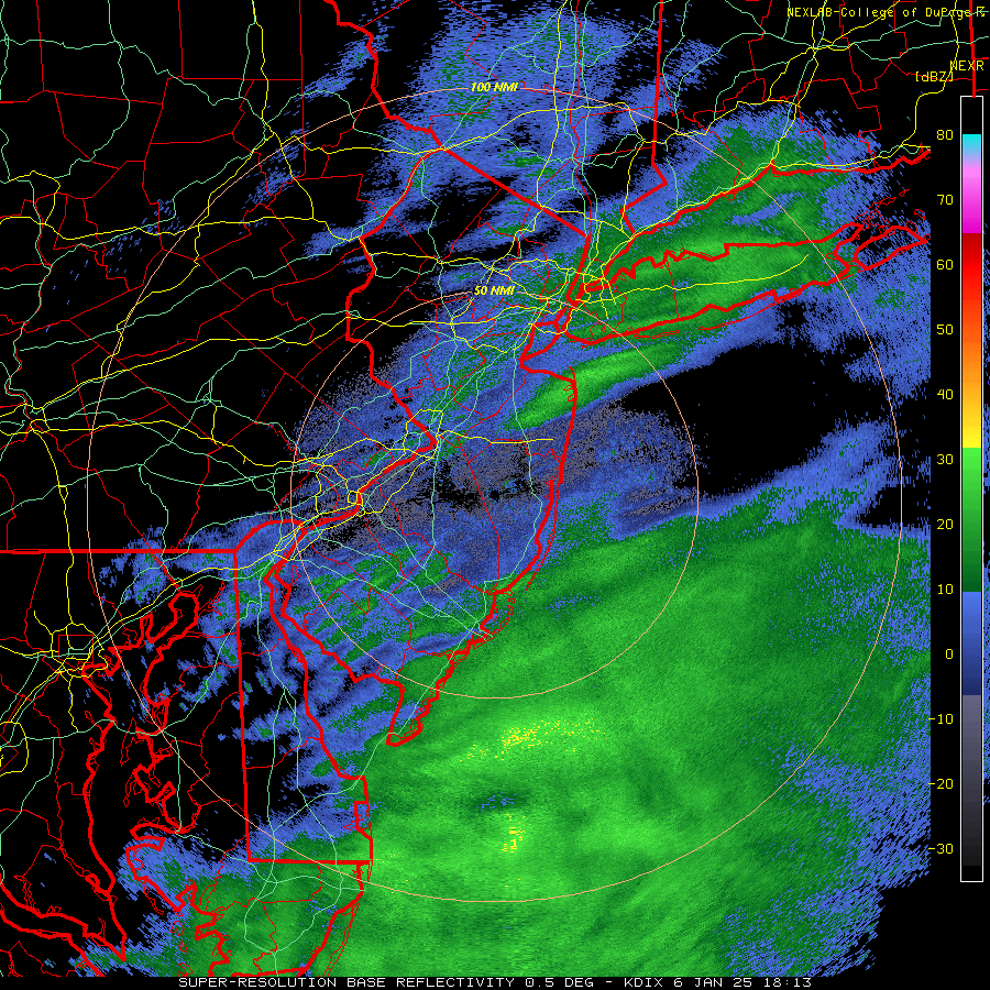
That last little band over us did the trick, moving us up to 1.2" for the storm and the radar truly looks done for us; temp up to 28F. That brings us to 5.8" for the winter, which is close to average for this point of the season. And great to hear so many people are getting 1" or so even in NENJ/NYC/LI, which is a nice surprise. So pretty out there. -
Snowfall NYC subforum Jan 6 and OBS if needed
RU848789 replied to wdrag's topic in New York City Metro
I had 1.1" at about the same time, but with the little band that could the past 30 minutes, I'd bet we got another 0.1", so about to go measure again for what should be the actual last time for this one, lol. -
Snowfall NYC subforum Jan 6 and OBS if needed
RU848789 replied to wdrag's topic in New York City Metro
Measured around 1:05 pm, thinking we were done, but 2 minutes later the snow picked up again and is still going decently, so might pick up another 0.1". It truly looks dry behind what we have now. My house is about 1/2 mile NW of where 287 and the NJTPK meet, so whenever someone says "north and west of 95" or "north of 287" I'm both, lol.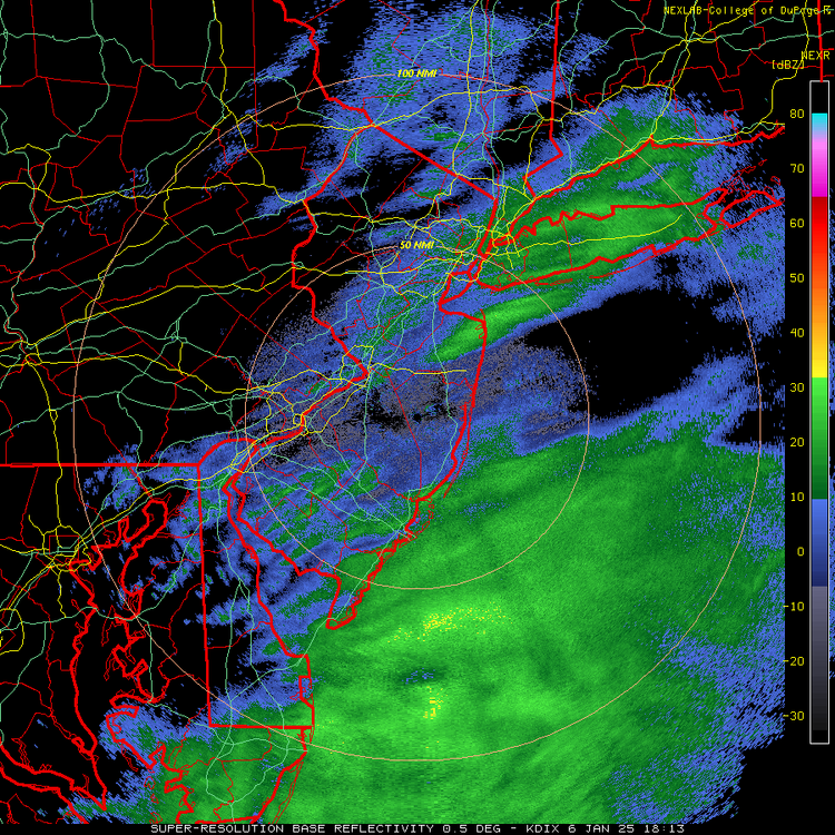
-
1/6 snowstorm - nuisance event or something bigger?
RU848789 replied to LVblizzard's topic in Philadelphia Region
As of about 1:05 pm, we're up to 1.1" and down to very light snow, with not much more on the radar to our west, so this might be it, unless we get a rogue band over the next hour or two. Not too far off my 1.5" prediction yesterday and more than I thought we were going to get around 9 am this morning when we got off to a slow start. Just enough snow for a few kids to sled on, although they left just before I got the latest pic below. -
Snowfall NYC subforum Jan 6 and OBS if needed
RU848789 replied to wdrag's topic in New York City Metro
As of about 1:05 pm, we're up to 1.1" and down to very light snow, with not much more on the radar to our west, so this might be it, unless we get a rogue band over the next hour or two. Not too far off my 1.5" prediction yesterday and more than I thought we were going to get around 9 am this morning when we got off to a slow start. Just enough snow for a few kids to sled on, although they left just before I got the latest pic below.