

RU848789
-
Posts
4,002 -
Joined
-
Last visited
Content Type
Profiles
Blogs
Forums
American Weather
Media Demo
Store
Gallery
Everything posted by RU848789
-
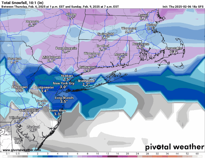
Looks like the NWS-Philly is going with the sleetier/icier forecast for almost everyone, given the advisories below with snow amounts decreased due to sleet and with freezing rain of 0.1-0.2" for most. For most of CNJ, where I live, 2" of sleet/snow with 0.2" of ice would have the equivalent frozen mass (the freezing rain will be absorbed by the sleet/snow, not melt it) of ~6" of 10:1 snow on all surfaces. This could be a shitstorm if places get 1/4" of ice accretion as per the NWS and some models which show even more. I think everyone would rather have all snow, but it's looking like a mix for anyone south of 78 and probably even south of 80 if these advisories are correct; wonder if Upton will follow suit. Also, nothing will melt overnight with temps at or below 32F for most until 9-10 am, so conditions in the morning will likely still be treacherous with 2" or so of snow/sleet then maybe 0.2" of ice on top of that. But who knows, maybe the snow will do better this time than yesterday. Edit: added in the newly updated NWS-Philly snow/ice maps, showing the significant deceases in snowfall forecasts for everyone, but people should know that the decreased snow will be replaced by sleet, not rain, so the frozen mass on the ground will be about the same and the amount of freezing rain forecast hasn't changed much (and that will add to the frozen mass on the ground). https://forecast.weather.gov/wwamap/wwatxtget.php?cwa=PHI&wwa=winter weather advisory URGENT - WINTER WEATHER MESSAGE National Weather Service Mount Holly NJ 101 PM EST Fri Feb 7 2025 NJZ009-010-012-015-PAZ054-061-062-105-106-080715- /O.NEW.KPHI.WW.Y.0007.250208T2000Z-250209T1100Z/ Hunterdon-Somerset-Middlesex-Mercer-Carbon-Lehigh-Northampton- Upper Bucks-Lower Bucks- Including the cities of Doylestown, Trenton, Bethlehem, Somerville, New Brunswick, Flemington, Jim Thorpe, Perkasie, Chalfont, Allentown, Morrisville, and Easton 101 PM EST Fri Feb 7 2025 ...WINTER WEATHER ADVISORY IN EFFECT FROM 3 PM SATURDAY TO 6 AM EST SUNDAY... * WHAT...Mixed precipitation expected. Total snow and sleet accumulations up to two inches and ice accumulations up to two tenths of an inch. URGENT - WINTER WEATHER MESSAGE National Weather Service Mount Holly NJ 101 PM EST Fri Feb 7 2025 NJZ013-020-022-027-080715- /O.NEW.KPHI.WW.Y.0007.250208T1700Z-250209T0700Z/ Western Monmouth-Ocean-Atlantic-Southeastern Burlington- Including the cities of Jackson, Wharton State Forest, Freehold, and Hammonton 101 PM EST Fri Feb 7 2025 ...WINTER WEATHER ADVISORY IN EFFECT FROM NOON SATURDAY TO 2 AM EST SUNDAY... * WHAT...Mixed precipitation expected. Total snow and sleet accumulations up to two inches and ice accumulations around one tenth of an inch. URGENT - WINTER WEATHER MESSAGE National Weather Service Mount Holly NJ 101 PM EST Fri Feb 7 2025 NJZ001-007-008-PAZ055-080715- /O.NEW.KPHI.WW.Y.0007.250208T2000Z-250209T1100Z/ Sussex-Warren-Morris-Monroe- Including the cities of Morristown, Washington, Newton, and Stroudsburg 101 PM EST Fri Feb 7 2025 ...WINTER WEATHER ADVISORY IN EFFECT FROM 3 PM SATURDAY TO 6 AM EST SUNDAY... * WHAT...Mixed precipitation expected. Total snow and sleet accumulations between 2 and 4 inches and ice accumulations up to one tenth of an inch. URGENT - WINTER WEATHER MESSAGE National Weather Service Mount Holly NJ 101 PM EST Fri Feb 7 2025 DEZ001-NJZ016>019-PAZ060-070-071-101>104-080715- /O.NEW.KPHI.WW.Y.0007.250208T1700Z-250209T1100Z/ New Castle-Salem-Gloucester-Camden-Northwestern Burlington-Berks- Delaware-Philadelphia-Western Chester-Eastern Chester-Western Montgomery-Eastern Montgomery- Including the cities of Honey Brook, Moorestown, West Chester, Oxford, Pottstown, Norristown, Wilmington, Camden, Mount Holly, Collegeville, Reading, Media, Glassboro, Lansdale, Pennsville, Kennett Square, Cherry Hill, and Philadelphia 101 PM EST Fri Feb 7 2025 ...WINTER WEATHER ADVISORY IN EFFECT FROM NOON SATURDAY TO 6 AM EST SUNDAY... * WHAT...Mixed precipitation expected. Total snow and sleet accumulations up to one inch and ice accumulations between one tenth and two tenths of an inch.
-
Finally found this, which really shows well the amounts of snow, sleet, freezing rain and rain for the 12Z NAM for selected locations. For Newark, it has 0.54" total precip, which includes 1.7" of snow (assumes 10:1 ratio), about 1.1" of sleet (from 0.37" of sleet as liquid and using a 3:1 ratio) and no freezing rain or plain rain. For Philly, it has 0.69" total precip, which includes 1.4" of snow, about 0.3" of sleet (from 0.11" of sleet as liquid and using a 3:1 ratio), but it also shows 0.42" of freezing rain (and no plain rain), which would be just terrible. Rule of thumb is maybe 1/2 to 2/3 of freezing rain precip actually accretes on sub-32F surfaces (some runs off, especially if precip is moderate to heavy; drizzle accumulates much better), meaning maybe 0.25" of ice accretion, which is close to the 0.17" of accumulated freezing rain from the NWS forecast. Biggest take home message is no plain rain, so this will be quite impactful even for areas south of 78 which might get a lot less pure snow, as sleet and freezing rain are as bad or worse. Even AC is only showing half of the 0.6" of total precip as plain rain. Of course, this is just the NAM model verbatim and the actual outcome might be much different as per the NWS with more snow and less sleet/freezing rain for most. https://coolwx.com/cgi-bin/getbufr.cgi?region=NJ&stn=KACY&model=nam&time=current&field=prec
-
GFS also showing more sleet where the sleet amount = (TT "snow" (which includes 10:1 sleet) - Pivotal pure snow)/3; when they show the same amount of "snow" that means no sleet. Would be nice to have a sleet map and a pure snow map, lol...
-
Huh? NAM has 0.5-0.7" QPF like most of the other models; it's just that most of it is sleet...
-
See my post above. TT counts sleet as 10:1 snow in their "snowfall" maps, meaning 2" of sleet would be about 6" of snow, so the NAM is spitting out about 2" of sleet and a little snow on TT. But Pivotal doesn't count sleet toward the snow total at all, which is why their NAM maps are only showing 1-2" of pure snow for most, at least south of 80. 2" of sleet has the same mass as 6" of snow, so the impact on driving/removal is the same - there just aren't visibility issues and it's not as pretty. It's above my pay grade to speculate on whether the NAM or the other models will be right, lol.
-
Remember even if the NAM is right (it's not always in these mix situations), it would still be very impactful to have 1-2" of sleet (same mass as 3-6" of snow at 3:1 sleet to liquid ratio vs. standard 10:1 snow to liquid ratios) and some ice on top of that instead of 3-6" of snow (for areas N of 78 currently forecast to get 3-6" of snow), but it certainly won't be as pretty or fun. The Pivotal vs. TT maps show that most of the "snow" on TT is sleet (Pivotal doesn't count sleet); would be nice to have a sleet map...
-
0Z Euro is nice...a bit more for folks south of 78 and south of 276/195, but a little less for folks north of 80 (but still 5-6")...
-
I think something is wrong with the Kuchera calculation for that CMC map. The algorithm is liquid equivalent ratio (RAT) is 12.0 + 2.0*(271.16-MaxT) and looking at Philly, for example, the 10:1 ratio is 4.0", whereas the Kuchera for Philly is essentially 0.0, which makes no physical sense at all, especially given the algorithm. For the SLR to be 0 means that the max column temp in the column would have to be 277.16K (6C or 42.8F), so the equation would be SLR = 12.0 + 2.0(271.16-277.16) = 0. It just makes no sense. It's another reason I almost always use 10:1 ratio maps, so I know how much QPF is falling as 10:1 snow and then one can still adjust. https://www.facebook.com/hopwrf/posts/562550350492139
-
0Z GFS zoomed in; nice improvements over 18Z for most, although those weird cutoffs/discontinuities persist - there's just no way Allentown gets 0.8" and Easton gets 3+".
-
0Z NAM and ICON, fwiw...still think the NAM map with the "hole" in CNJ is improbable (I get a bigger early thump SW of CNJ and more N of CNJ with the later coastal, but not sure I've ever seen this before). Also, kind of curious if folks in this forum like seeing the zoomed in Pivotal maps or the regional mid-Atlantic or NEUS maps.
-
The demonization of good science, from climate/weather to vaccines to public health, in general, by this Administration (among other things) is unconscionable and will set this country back in many ways and make it less safe and less healthy.
-
Advisories north of 276/195 are for 3" not 1" (and 2" south of 276/195); but advisories can be posted for less snowfall when freezing rain over 0.01" is expected, as we just saw today. Also, I was once told by a NWS person that the criterion for a county needs to be met for at least half of that county, i.e., a warning for Essex County, for example is where 6" is expected for at least half of the county (which is why so many counties with often sharp gradients are split in half). The maps below are at the linked website. https://www.weather.gov/phi/WinterWx 12 Hour Advisory Snowfall: 12 Hour Snowfall Warning Criteria Ice Storm Warning Crtieria
-
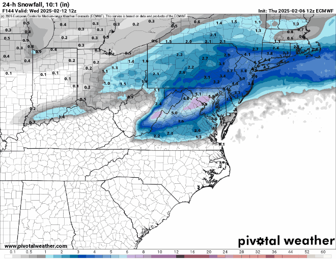
Posted this 2 hours ago in the wrong thread, lol - hard to keep track. Nice to see the Euro beefing up precip/snowfall for 18Z vs. 12Z for the 2/11-12 event. Now the GFS, Euro, CMC and UK are all showing at least 4-8" for our region with the GFS showing 8-12"+ at 18Z. Extremely strong signal for a storm 5 days out.
-
Ok, rank your excitement on a scale of 1 to Cantore-Thundersnow for next week vs. the mid-Jan pattern that was quite cold and produced some snow for our area, but had two major storm miss us to the south. :>)
-
Nice to see the Euro beefing up precip/snowfall vs. 12Z. Now the GFS, Euro, CMC and UK are all showing at least 4-8" for our region with the GFS showing 8-12"+ at 18Z. Extremely strong signal for a storm 5 days out.

-
Sorry, but Kuchera often sucks, as it uses a very crude algorithm based only on max column temp and ignores crystal growth parameters that "create" snow ratios. I much prefer 10:1, so I know exactly how much QPF goes into the calculation and can adjust easily low or high from that number based on other factors. Kuchera can be useful close to an event when column temps and snow growth parameters are much better known. The HRRR, RAP and some other models were high because they assumed snow and we got sleet at 2-3:1, which has a far lower ratio than Kuchera or obviously 10:1 snow - precip type is way more important than snow ratio estimates in this case. Also, if we knew most of the QPF was going to be sleet, it would've been a simple ~3 to 1 conversion to estimate the sleet accumulation vs. the 10:1 accumulation, whereas that would be very difficult with Kuchera.
-
I was quite surprised, since they've often gone with the GFS and did that famously for the Jan-15 bust for our area, where they were the only ones predicting around a foot or so for NYC metro (per the GFS) vs. the 20-30" predicted by the NWS and others (likely following the euro which never wavered for days, but was wrong, as the storm was essentially displaced 70 miles east of the forecast). But the GFS is the least snowy model for this weekend, so not sure what they're following or if they make completely original forecasts now.
-
We already have a couple of fairly snowy predictions being made by both News12 and TWC, which both have a lot more snow forecast than today's event, as per the maps below. On the other hand, as per below (since no map yet), the NWS is a bit less bullish with 1-3" from about 276/195 to 78 and 3-5" north of 78, but 1" or less south of 276/195 (including Philly/SNJ). Stay tuned. .SHORT TERM /FRIDAY THROUGH SUNDAY/... In terms of amounts, the current forecast calls for 0.40-0.70" of liquid QPF. Breaking this down into snow/sleet totals, anticipate a C-1" for the northern Delmarva and much of the I-95 corridor including the Philadelphia metro. Just north of the I-95 corridor up to and including the I-78 corridor, expecting 1-3". Once north of the I-78 corridor and especially north of I-80, amounts upwards of 3- 5" are possible. There will also be freezing rain accretion over most of the area, but amounts should generally range from a T-0.1" (locally higher). Considering this, Winter Weather headlines will likely be needed within the next 24-48 hours.
-
Storm over for me as of about 8:15 am when it went to 33F and light rain and it's over for most of CNJ (especially along/SE of 95), at least; final measurement was 0.4" of mostly sleet, bringing my winter total up to 11.1". Temps up to 33-35F along and SE of 95 with light rain falling and the radar looks like the worst of the precip is over, although we still might get another 0.1-0.2" of rain - and this is very likely still sleet or maybe freezing rain 15-20 miles NW of 95 (i.e., a Doylestown to Morristown to Mahwah line where it's still in the 30-32F range and further NW of there where it's in the upper 20s.
-
Storm over for me and most of CNJ, at least; final measurement was 0.4" of mostly sleet, bringing my winter total up to 11.1". Temp up to 33F and is 33-35F along and SE of 95 with light rain falling and the radar looks like the worst of the precip is over, although we still might get another 0.1-0.2" of rain - and this is very likely still sleet or maybe freezing rain 15-20 miles NW of 95 (i.e., a Doylestown to Morristown to Mahwah line where it's still in the 30-32F range and further NW of there where it's in the upper 20s.
-
It's a kind of forecast bust, as per my recent post, since the snow predicted didn't materialize, but the mass of frozen precip that fell (0.5" of sleet is about the water equivalent of 1.5" of snow at 3:!) was spot on and the impacts have been substantial on the roads with regard to accidents and slips/falls, so definitely not a "big picture impact" bust at all.
-
Thanks for the kind words. I was only using the word "bust" with reference to the forecast of 1-2" of "snow" by the NWS (their map had all of CNJ/NNJ in their 1-2" swath and point and click forecasts were around 1.2-1.5" for most) and many others for CNJ and beyond, as well as the predictions by most models showing 1-2" to 2-4" of snow, but the forecast was definitely not a bust with regard to impact, as we both agree that sleet is just as impactful to travel/removal as snow (maybe moreso as it melts more slowly), as sleet is just as difficult to drive/walk on as snow (maybe worse) and there are many, many accidents being reported. In hindsight it's interesting to look at the NAM in more detail, as it was the only one really showing <1" of snow due to an earlier changeover to sleet. This can be seen in the 0Z run last night, where the Pivotal snowmap shows <0.5" of snow for most, but the Tropical Tidbits map was showing ~2" of "snow" for most of NJ - but on TT, sleet is reported as 10:! ratio snow by the model, whereas Pivotal doesn't count sleet at all. 2" of sleet would be about 2/3" of "snow" on the ground given about a 3:1 sleet:liquid ratio (or even 1/2" at 2:1 ratio; sleet is often 2-4:1 ratio and I don't know what this sleet is), which is not far off my 0.4" and reports of 0.5" or more of sleet for many. By inference, the NAM was predicting about 2/3" of mostly sleet. I think there are some service providers that give actual snow and sleet accumulation forecasts, but I don't have access to those (I think NCEP has them), so I had to do the comparison/analysis by inference.
-
Up to 32F but still sleeting with some freezing rain mixed in with 0.4" of mostly sleet on the ground. Looks like this is about over for us, as temps are above 32F to my S/SE/E and even NE. Temps still 30F or less from about New Hope to Somerville to Madison and NW of that line, so more frozen to go there.
-
Still 31F here with sleet falling, but 33F reported in Carteret about 7-8 miles to my ENE - wonder if being a bit further west matters for this one with regard to being a little colder. Paved surfaces are very slippery.
-
Everything is coated with a very slippery layer of snow/sleet and any untreated surfaces are treacherous; even the brined road we live on is very slippery. As I've said countless times, when it comes to impacts on travel and removal, frozen mass is way more important than depth (except for visibility impacts which are nil for sleet); also, sleet melts more slowly than snow once temps go above 32F, given the much lower surface area to volume/mass ratio (less surface area is exposed to warmer air per unit mass). Up to 31F now and worried about freezing rain coming, although still a mixture of maybe 80% sleet/20% snow.


