vortmax
-
Posts
4,642 -
Joined
-
Last visited
Content Type
Profiles
Blogs
Forums
American Weather
Media Demo
Store
Gallery
Everything posted by vortmax
-
 I am, too far east for Erie, too far south for Ontario.
 -
Everyone focuses on their own areas. Especially for lake effect. Just how it is and it's quite alright. Embrace the fun.
-
Started snowing up on the lake now. Just turned to sleet. Crap! jk
-
Upstate NY Banter and General Discussion..
vortmax replied to wolfie09's topic in Upstate New York/Pennsylvania
That's crazy! How'd you get the graph from your Tempest? -
Widespread Snow Potential January 16th to January 18th
vortmax replied to sferic's topic in Upstate New York/Pennsylvania
So KBUF said the precip is coming an hour early. Is that because of the storm moving faster or a larger precip shield? -
Widespread Snow Potential January 16th to January 18th
vortmax replied to sferic's topic in Upstate New York/Pennsylvania
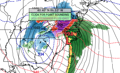
Trying to understand why the HRRR jumps the LP to the coast, weakens the primary, then re-strenghtens it, and ultimately merges the 2 again further west. Anyone wanna explain that one?? -
Widespread Snow Potential January 16th to January 18th
vortmax replied to sferic's topic in Upstate New York/Pennsylvania
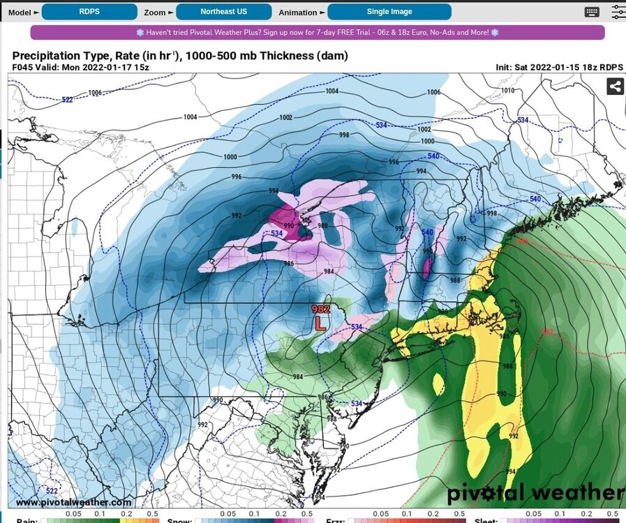
Yes, I just edited. Still weaker so far. Will this thing really retrograde NW and then go due North into C-PA? Not sure. -
Widespread Snow Potential January 16th to January 18th
vortmax replied to sferic's topic in Upstate New York/Pennsylvania
See my post? Surface map at 21z had the LP at 1000mb, the 3k NAM at 21z was 993. EDIT: 23z surface is now 996 (like you said), 3k NAM has it at 994. The move the LP NW a bit then due North. Hmm. -
Widespread Snow Potential January 16th to January 18th
vortmax replied to sferic's topic in Upstate New York/Pennsylvania
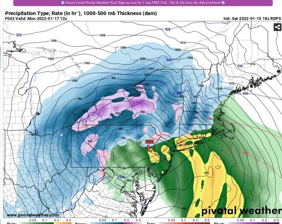
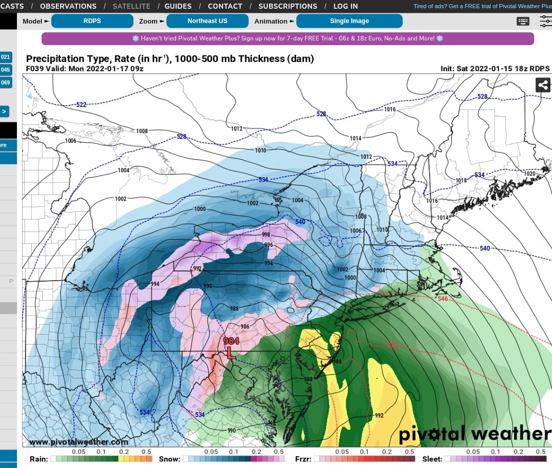
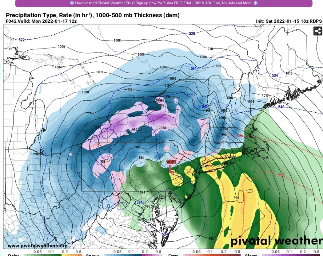
979 in Central PA?? Wow, is this thing trending stronger on the current surface map? 1000mb double barrel. Is this jumping to the coast early?? 18z NAM at about the same hour is 994....WAY over-amped... 3k NAM has the LP at 993 at 21z (surface map above is 21z - 1000mb)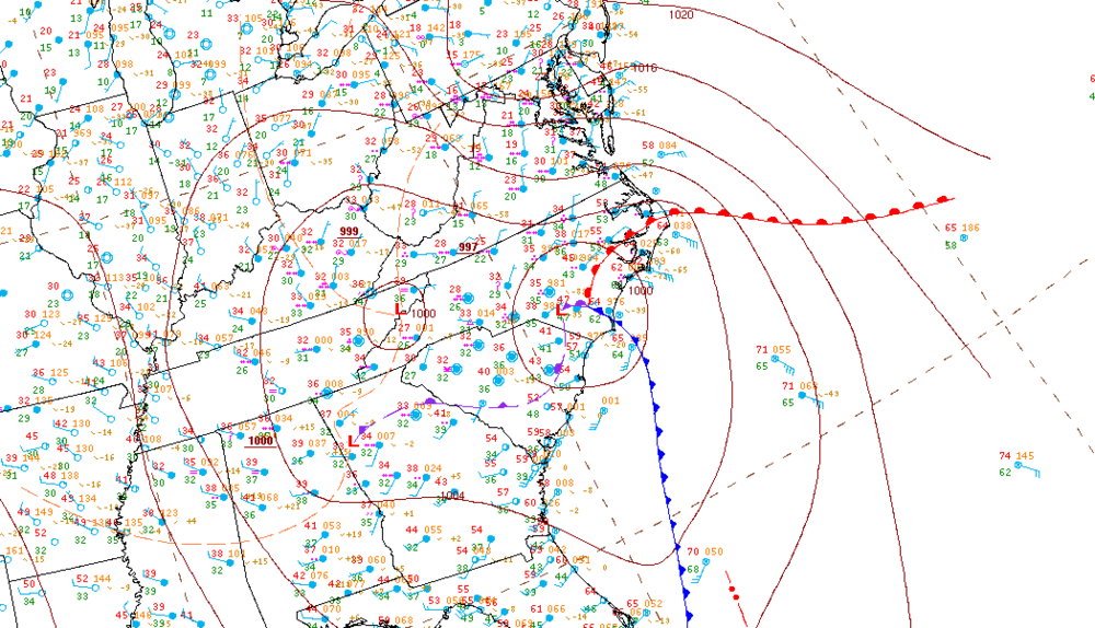
-
Widespread Snow Potential January 16th to January 18th
vortmax replied to sferic's topic in Upstate New York/Pennsylvania
And I'm starting this event off with grass not covered this season yet. -
Widespread Snow Potential January 16th to January 18th
vortmax replied to sferic's topic in Upstate New York/Pennsylvania
Warmer than average lake too. -
Widespread Snow Potential January 16th to January 18th
vortmax replied to sferic's topic in Upstate New York/Pennsylvania
10:1? -
Widespread Snow Potential January 16th to January 18th
vortmax replied to sferic's topic in Upstate New York/Pennsylvania
Should stay there overnight! -
Widespread Snow Potential January 16th to January 18th
vortmax replied to sferic's topic in Upstate New York/Pennsylvania
Matt should start a CNY pingslot obs thread. -
Widespread Snow Potential January 16th to January 18th
vortmax replied to sferic's topic in Upstate New York/Pennsylvania
I was thinking than too. -
Widespread Snow Potential January 16th to January 18th
vortmax replied to sferic's topic in Upstate New York/Pennsylvania
I'm no pro, but I would be shocked if there were any sleet mixed in that. -
Widespread Snow Potential January 16th to January 18th
vortmax replied to sferic's topic in Upstate New York/Pennsylvania
From -3 to 23 here. Should hit 30. -
Widespread Snow Potential January 16th to January 18th
vortmax replied to sferic's topic in Upstate New York/Pennsylvania
Doesn't anyone think there will be enough dynamic cooling in the def zone to prevent any mixing? I mean we are talking about a rapidly deepening 980 low. -
Widespread Snow Potential January 16th to January 18th
vortmax replied to sferic's topic in Upstate New York/Pennsylvania
So did the NAM shift east? -
Widespread Snow Potential January 16th to January 18th
vortmax replied to sferic's topic in Upstate New York/Pennsylvania
I'm being greedy, but would really like to see the US models cave. -
Widespread Snow Potential January 16th to January 18th
vortmax replied to sferic's topic in Upstate New York/Pennsylvania
Not digging the 00z GFS. Canada vs US -
Widespread Snow Potential January 16th to January 18th
vortmax replied to sferic's topic in Upstate New York/Pennsylvania
I just don't buy that. Dynamic cooling is gonna win. -
Widespread Snow Potential January 16th to January 18th
vortmax replied to sferic's topic in Upstate New York/Pennsylvania
Easy trigger. -
Widespread Snow Potential January 16th to January 18th
vortmax replied to sferic's topic in Upstate New York/Pennsylvania
True, true -
Widespread Snow Potential January 16th to January 18th
vortmax replied to sferic's topic in Upstate New York/Pennsylvania
Didn't really change much from 18Z. The RGEM really keeps that Def band more west - east along the South Shore. Hmm.