vortmax
-
Posts
4,642 -
Joined
-
Last visited
Content Type
Profiles
Blogs
Forums
American Weather
Media Demo
Store
Gallery
Everything posted by vortmax
-

Upstate/Eastern NY Spring Discussion/Obs Thread
vortmax replied to U_Thant's topic in Upstate New York/Pennsylvania
I’ll come! lol -
Upstate/Eastern New York-Fall
vortmax replied to BuffaloWeather's topic in Upstate New York/Pennsylvania
Here's to hope... -
Upstate/Eastern New York-Fall
vortmax replied to BuffaloWeather's topic in Upstate New York/Pennsylvania
Ended up with 0.62" today. Grass is finally looking alive again! -
Upstate/Eastern New York-Springtime?
vortmax replied to BuffaloWeather's topic in Upstate New York/Pennsylvania
Popping...
-
Upstate/Eastern New York-Springtime?
vortmax replied to BuffaloWeather's topic in Upstate New York/Pennsylvania
Up to 1.5" now. Very happy. -
Upstate/Eastern New York-Springtime?
vortmax replied to BuffaloWeather's topic in Upstate New York/Pennsylvania
Finally got some rain. About .5" so far, can almost hear the grass gulping it... -
Upstate/Eastern New York-Springtime?
vortmax replied to BuffaloWeather's topic in Upstate New York/Pennsylvania
Hoping to see some nighttime elevated convection with the passage of the warm front. KBUF doesn't seem too impressed. It will be very muggy tonight as a well established southerly flow ahead of an approaching cold front advects in lower 70s dewpoints across our region. Temps will remain very warm with lows in the low to mid 70s, warmest Niagara Frontier to St. Lawrence River valley. Convection chances tonight are dependent on upstream trends. Not very confident in any one solution based on how models have performed since last night. In general the models were too far north and west with convection last night and are similar today. With that in mind and since warm front will be north of here allowing for ample elevated instability to settle across along with a low-level jet in place, made sure to have at least chance pops this evening over western NY and northern North Country, then blended this with going forecast chancy pops over from western NY to North Country later tonight. Better chances for storms tonight *likely* will remain just north of our area across southern Ontario and southern Quebec along advancing warm front and where stronger temp/moisture advection are present. It will be a nowcasting type of scenario though. -
Upstate/Eastern New York-Springtime?
vortmax replied to BuffaloWeather's topic in Upstate New York/Pennsylvania
IMO, it's been the best Spring/Summer we've had in a long time. -
Upstate/Eastern New York-Springtime?
vortmax replied to BuffaloWeather's topic in Upstate New York/Pennsylvania
White Christmas? -
Upstate/Eastern New York-Springtime?
vortmax replied to BuffaloWeather's topic in Upstate New York/Pennsylvania
Take some pics of waterspouts! -
Upstate/Eastern New York-Springtime?
vortmax replied to BuffaloWeather's topic in Upstate New York/Pennsylvania
Who thinks this will shift east a little later today? -
Upstate/Eastern New York-Springtime?
vortmax replied to BuffaloWeather's topic in Upstate New York/Pennsylvania
Agreed. Not many extremes...either way. -
Upstate/Eastern New York-Springtime?
vortmax replied to BuffaloWeather's topic in Upstate New York/Pennsylvania
Will be interesting to see how this verifies at the end of the day today. -
Upstate/Eastern New York-Springtime?
vortmax replied to BuffaloWeather's topic in Upstate New York/Pennsylvania
Key word in those charts is "Outlook". Come on Brent, stop with the shenanigans please. This is a weather page in which we talk about past, present and future forecasts. -
Upstate/Eastern New York-Springtime?
vortmax replied to BuffaloWeather's topic in Upstate New York/Pennsylvania
Pretty colors...lol -
Upstate/Eastern New York-Springtime?
vortmax replied to BuffaloWeather's topic in Upstate New York/Pennsylvania
Yea, if we didn't get a lucky hit by a heavy cell with about .35" in a 15 min downpour, we'd be in the same boat. -
Upstate/Eastern New York-Springtime?
vortmax replied to BuffaloWeather's topic in Upstate New York/Pennsylvania
The December timeframe must be related to the longwave patterns as the planet hits the solstice. What area does that graph cover or is it a single site? -
Upstate/Eastern New York-Springtime?
vortmax replied to BuffaloWeather's topic in Upstate New York/Pennsylvania
Why couldn't that blip be in April? -
Upstate/Eastern New York-Springtime?
vortmax replied to BuffaloWeather's topic in Upstate New York/Pennsylvania
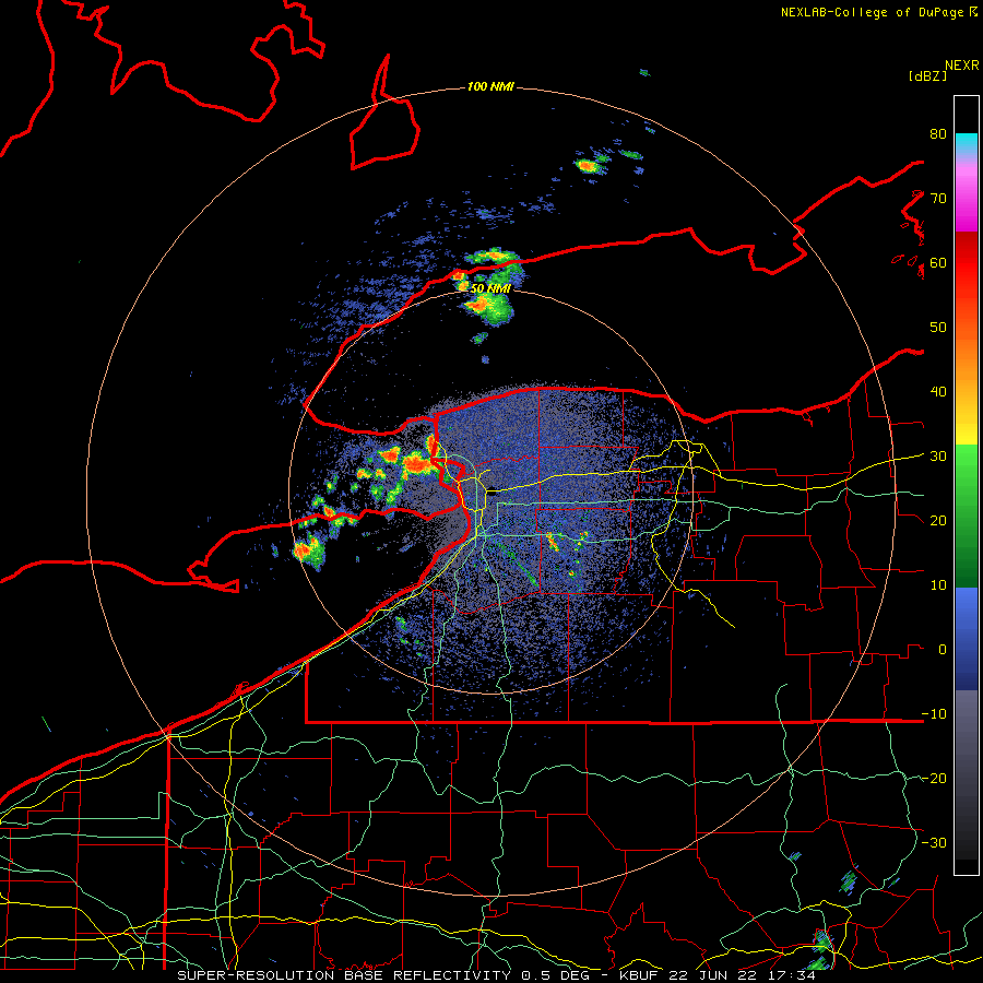
We only got .06" easy of you. The line split around eastern Monroe cty. Interesting. -
Upstate/Eastern New York-Springtime?
vortmax replied to BuffaloWeather's topic in Upstate New York/Pennsylvania
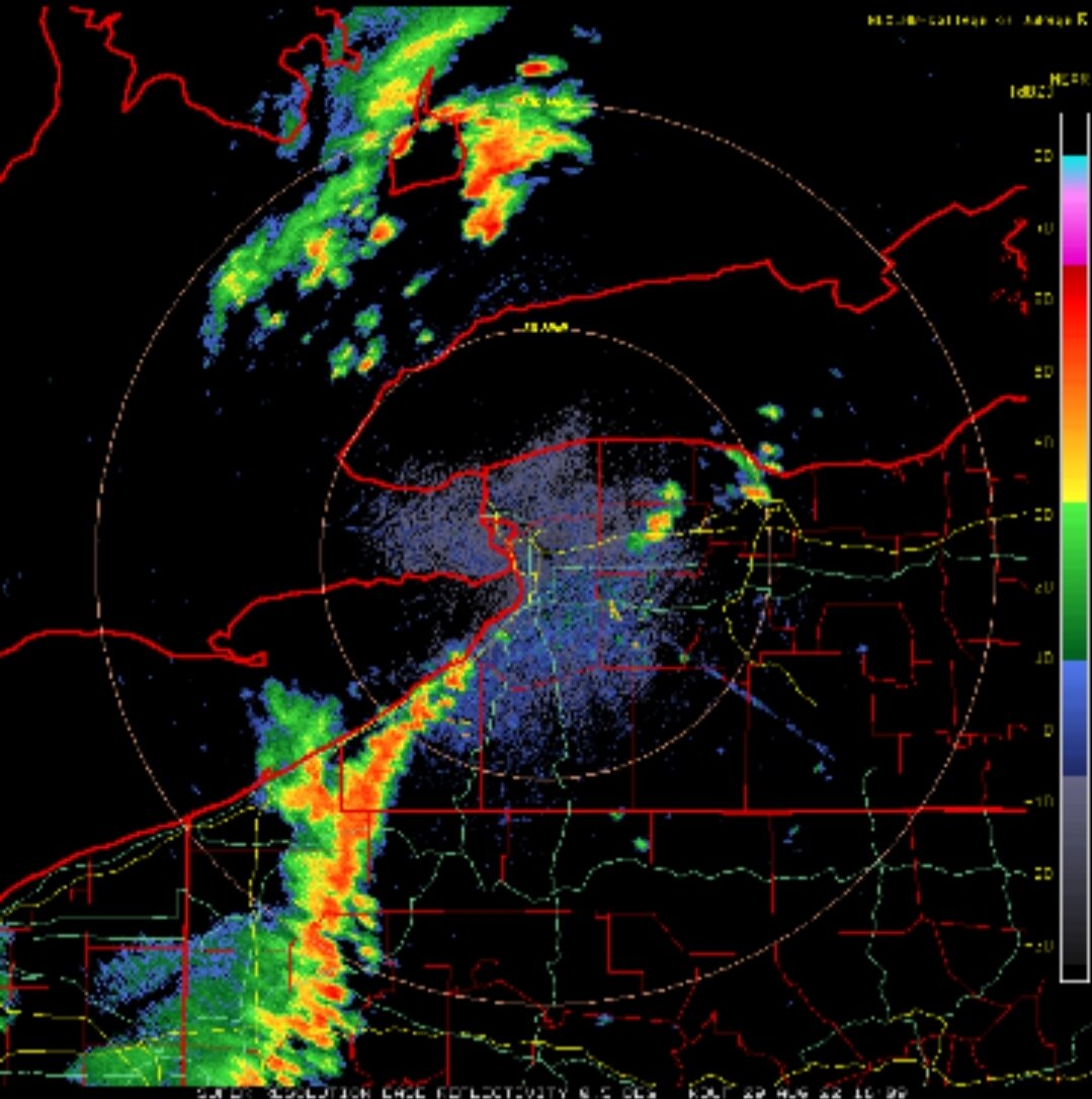
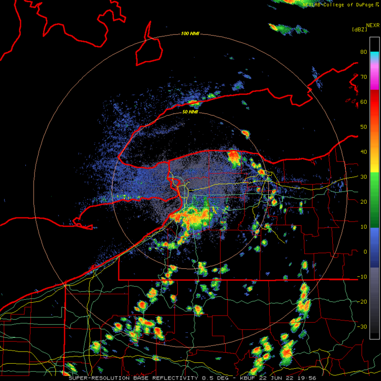
More popping east now along the outflow...
-
Upstate/Eastern New York-Springtime?
vortmax replied to BuffaloWeather's topic in Upstate New York/Pennsylvania
Something is happening...
-
Upstate/Eastern New York-Springtime?
vortmax replied to BuffaloWeather's topic in Upstate New York/Pennsylvania
Let's see how this rolls. -
Upstate/Eastern New York-Springtime?
vortmax replied to BuffaloWeather's topic in Upstate New York/Pennsylvania
You were saying?
-
Upstate/Eastern New York-Springtime?
vortmax replied to BuffaloWeather's topic in Upstate New York/Pennsylvania
Wow, pretty intense. Totally agree, you could watch all those cells just pop on the east side of that layer, one after another. -
Upstate/Eastern New York-Springtime?
vortmax replied to BuffaloWeather's topic in Upstate New York/Pennsylvania
It seems even when severe parameters are quite favorable, the marine air wins out every time. The only storms that seem to survive/thrive are the elevated warm frontal ones.