vortmax
-
Posts
4,642 -
Joined
-
Last visited
Content Type
Profiles
Blogs
Forums
American Weather
Media Demo
Store
Gallery
Everything posted by vortmax
-

Widespread Snow Potential January 16th to January 18th
vortmax replied to sferic's topic in Upstate New York/Pennsylvania
Still time for a SE tick or 2. -
Widespread Snow Potential January 16th to January 18th
vortmax replied to sferic's topic in Upstate New York/Pennsylvania
Thanks for the laughs folks. I'm goin to bed with some nice snow falling!
-
Widespread Snow Potential January 16th to January 18th
vortmax replied to sferic's topic in Upstate New York/Pennsylvania
Haven't been on in a couple hours. Who are all these people? Lol -
Widespread Snow Potential January 16th to January 18th
vortmax replied to sferic's topic in Upstate New York/Pennsylvania
A pause... -
Widespread Snow Potential January 16th to January 18th
vortmax replied to sferic's topic in Upstate New York/Pennsylvania
What's going on with our LE Tim? I watched a sunset. -
Widespread Snow Potential January 16th to January 18th
vortmax replied to sferic's topic in Upstate New York/Pennsylvania
You go west, I go east. -
Widespread Snow Potential January 16th to January 18th
vortmax replied to sferic's topic in Upstate New York/Pennsylvania
BFF -
Widespread Snow Potential January 16th to January 18th
vortmax replied to sferic's topic in Upstate New York/Pennsylvania
Waiting for reds along the South Shore. -
Widespread Snow Potential January 16th to January 18th
vortmax replied to sferic's topic in Upstate New York/Pennsylvania
And so the SE shift begins... -
Widespread Snow Potential January 16th to January 18th
vortmax replied to sferic's topic in Upstate New York/Pennsylvania
We'll see. Haven't had much luck with LE this season here. -
Widespread Snow Potential January 16th to January 18th
vortmax replied to sferic's topic in Upstate New York/Pennsylvania
Not getting anything in Ontario. Really... Lol Although models have precip mostly overnight. -
Widespread Snow Potential January 16th to January 18th
vortmax replied to sferic's topic in Upstate New York/Pennsylvania

-
Widespread Snow Potential January 16th to January 18th
vortmax replied to sferic's topic in Upstate New York/Pennsylvania
.2" of that is pre-storm. NIA gets 2.00"+ from synoptic only. I still think we're going to see the SE shift begin tonight. -
Widespread Snow Potential January 16th to January 18th
vortmax replied to sferic's topic in Upstate New York/Pennsylvania
Euro almost gives south shore .2" from LE alone....hmmm. -
Widespread Snow Potential January 16th to January 18th
vortmax replied to sferic's topic in Upstate New York/Pennsylvania
Euro coming in hot and west....yikes. NIA the winner. -
Widespread Snow Potential January 16th to January 18th
vortmax replied to sferic's topic in Upstate New York/Pennsylvania
Looking at the Ukie and trying to determine the differences. Only thing I could really find is that it doesn't seem to have that double barrel LP look to it - keeps a single (and stronger) LP the entire run (purer Miller A), keeping a narrower precip field. The others seem to transfer towards the convection just below our latitude. Question is, which scenario plays out, Miller A vs hybrid. -
Widespread Snow Potential January 16th to January 18th
vortmax replied to sferic's topic in Upstate New York/Pennsylvania
NIA is the winner then. -
Widespread Snow Potential January 16th to January 18th
vortmax replied to sferic's topic in Upstate New York/Pennsylvania
Only its 2 runs (12Z and 00Z). 12Z yesterday was way more west. All eyes on EC to see if it holds. -
Widespread Snow Potential January 16th to January 18th
vortmax replied to sferic's topic in Upstate New York/Pennsylvania
12Z GEM at 60hr already 4mb stronger with LP (than 00Z) -
Widespread Snow Potential January 16th to January 18th
vortmax replied to sferic's topic in Upstate New York/Pennsylvania
Anyone want to analyze the upper levels and for any noticeable differences? Seems the LP placement has changed a bit from 06Z. Maybe due to northern stream energy digging a bit more creating a slightly more negative tilt? -
Widespread Snow Potential January 16th to January 18th
vortmax replied to sferic's topic in Upstate New York/Pennsylvania
12Z GFS running. Pretty similar to 06Z so far, maybe a bit slower. Northern stream seems to be digging a bit more. LP 3mb stronger at our lattitude. Precip shield moved west again. 25-50 miles. -
Widespread Snow Potential January 16th to January 18th
vortmax replied to sferic's topic in Upstate New York/Pennsylvania
At the very least, we'll see LE snow showers and a few more inches on very tail end. That would be nice. RH, 850s, wind, cyclonic flow all favor this as the LP is pulling away. Then the clipper, then more LE, then another storm possible 10 days out. -
Widespread Snow Potential January 16th to January 18th
vortmax replied to sferic's topic in Upstate New York/Pennsylvania
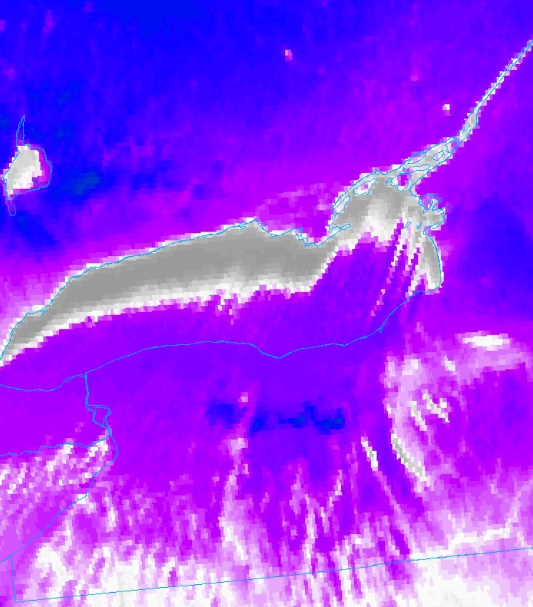
Y'all realize you're talking about the NAM at 66+hrs right? See below: -
Widespread Snow Potential January 16th to January 18th
vortmax replied to sferic's topic in Upstate New York/Pennsylvania
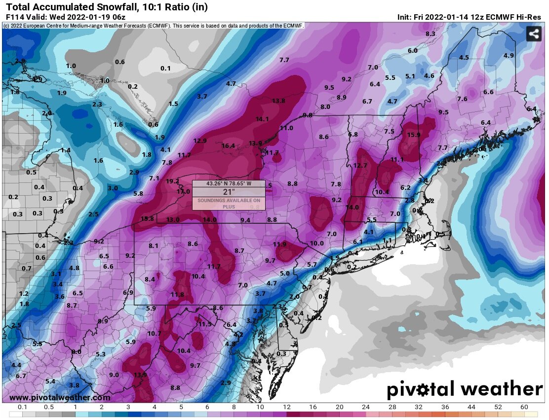
That seems reasonable. Seems like a long time since I've seen 3"/hr rates synoptically. -
Widespread Snow Potential January 16th to January 18th
vortmax replied to sferic's topic in Upstate New York/Pennsylvania
Anyone think gravity waves are going to play a role in the banding?