Hurricane Agnes
-
Posts
9,263 -
Joined
Content Type
Profiles
Blogs
Forums
American Weather
Media Demo
Store
Gallery
Everything posted by Hurricane Agnes
-
E PA/NJ/DE Spring 2023 OBS Thread
Hurricane Agnes replied to Hurricane Agnes's topic in Philadelphia Region
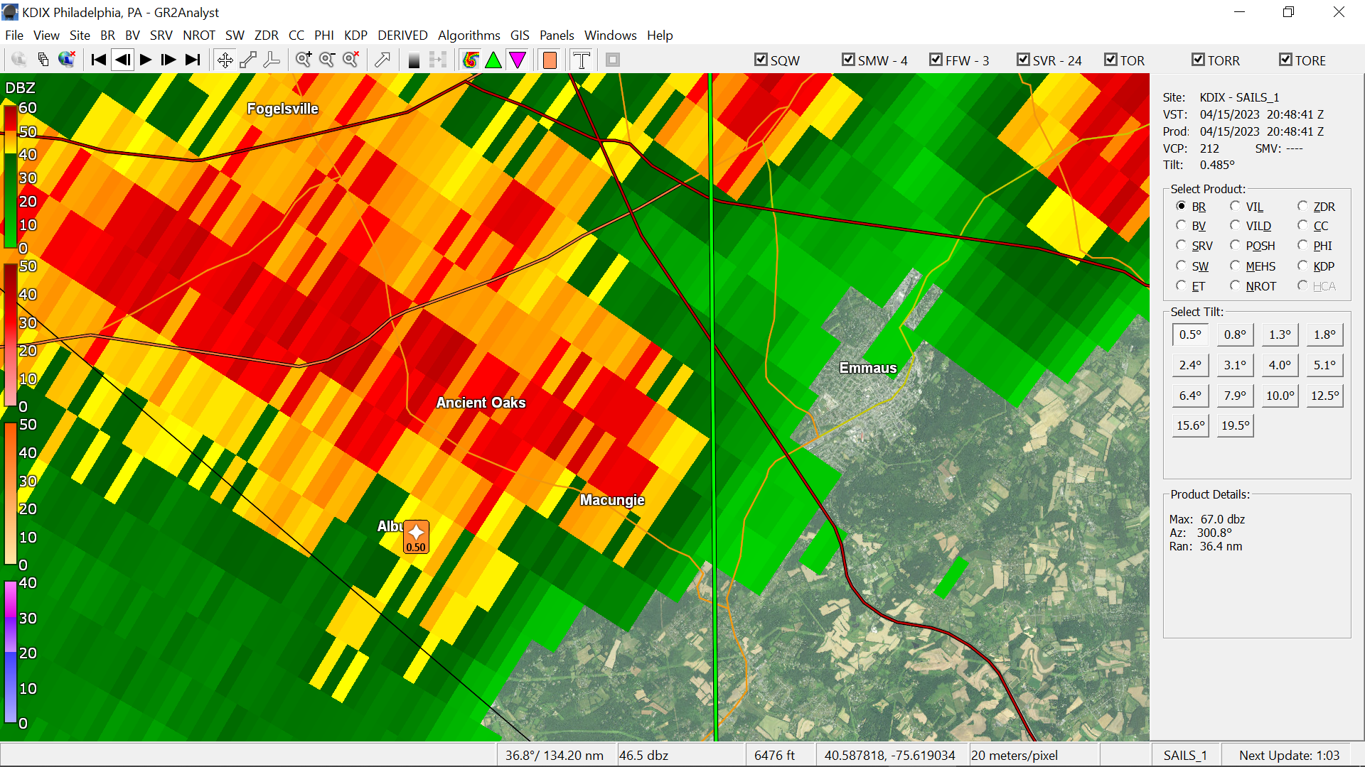
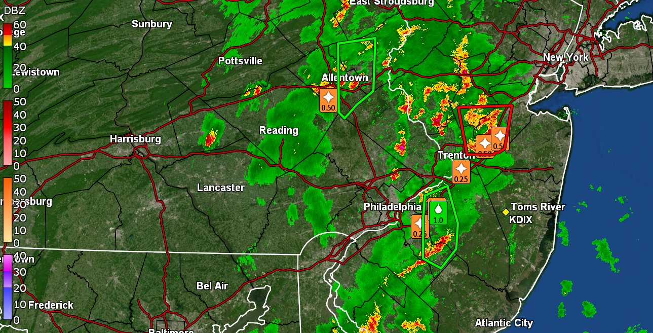
The cell(s) just sat over that general area for hours. There was a flash flood in Ancient Oaks too... Bur I had this vision of you doing this - Ended up with 77 as a high yesterday and 0.01" of rain. It's currently 60, overcast and misty with low stratus and a dp of 59. -
E PA/NJ/DE Spring 2023 OBS Thread
Hurricane Agnes replied to Hurricane Agnes's topic in Philadelphia Region
I have been in a hole here too - stuff to the north and west. Have exactly 0.01" from when I had originally reported drizzle and nothing since. I know sometimes in these "popcorn storm" situations, something can bubble up out of nowhere but if not, then I suppose I can look forward to Monday. Currently changeable skies and 72 with dp 61. -
E PA/NJ/DE Spring 2023 OBS Thread
Hurricane Agnes replied to Hurricane Agnes's topic in Philadelphia Region
Need some validation!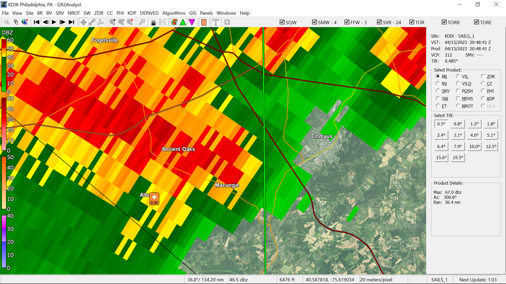
-
E PA/NJ/DE Spring 2023 OBS Thread
Hurricane Agnes replied to Hurricane Agnes's topic in Philadelphia Region
Sun's been in and out and with it out now for a little longer, some popcorn stuff is bubbling up including something up near birds. Have been hearing thunder and getting convection registering on the detector. Currently some foreboding clouds but party sunny and 74 with dp 63.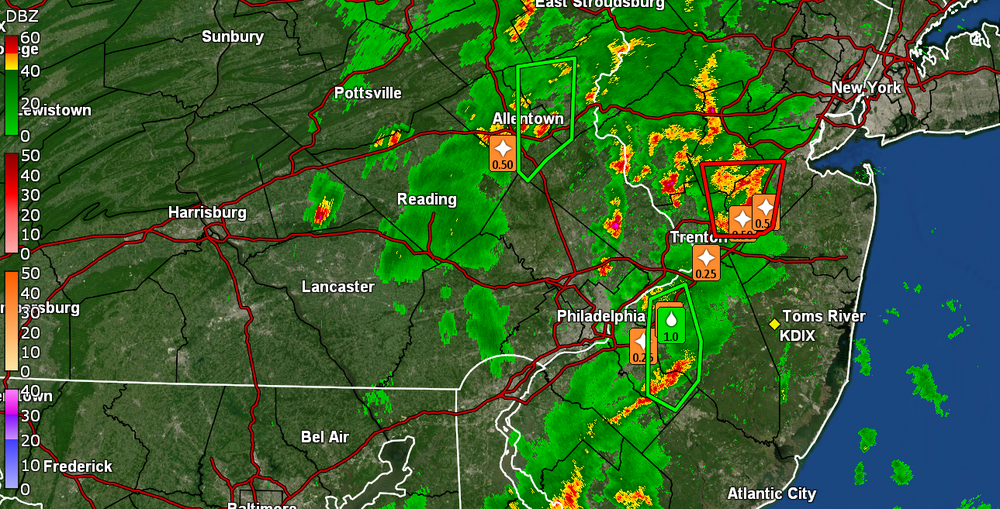
-
E PA/NJ/DE Spring 2023 OBS Thread
Hurricane Agnes replied to Hurricane Agnes's topic in Philadelphia Region
Getting some dribbles out there (was out dividing some perennials). I think my accumulation of hail last month was "winter". Currently overcast, 73, and drizzling strike that, am actually getting rain now, with a humid dp of 66. Am also picking up some convection on my lightning detector. -
E PA/NJ/DE Spring 2023 OBS Thread
Hurricane Agnes replied to Hurricane Agnes's topic in Philadelphia Region
I "heard" the notifications beeping for here, checked my radar, and sure enough saw something had spontaneously appeared up north. Am wondering if our buddy in Macungie is outside dancing naked in any rain (or hail). I ended up bbing yesterday afternoon figuring it would have been raining here today (at least some spotty showers were forecast beginning overnight and into the morning, and on/off all day. Haven't had any of that yet but at least yesterday was pleasant. It has been mostly overcast here with some occasional self-destruct sun. Am currently at 77, which is my high so far for the day (nowhere near the highs the past couple days), after a low of 62, and with a more juicy dp of 66. -
E PA/NJ/DE Spring 2023 OBS Thread
Hurricane Agnes replied to Hurricane Agnes's topic in Philadelphia Region
Made it up to 86 for a high today in the "cooler" parts of the CWA based on the position of the high. Just came in after firing up the grill and getting some stuff cooked up for next week, and the temps today were fantastic. Not blazing hot nor humid. I know the rain is incoming this weekend so wanted to get the grill-on now. Currently all clouded up, 80, and am seeing stuff lifting up from the south. But have a dp that is a pleasant 44. -
E PA/NJ/DE Spring 2023 OBS Thread
Hurricane Agnes replied to Hurricane Agnes's topic in Philadelphia Region
When one of my sisters moved into her house back in the summer of 2003, her neighbor's oak tree was literally raining down a billion acorns that fall. You could barely sit out on her deck without getting the equivalent of weeks of hail (but not with ice) raining down until frost. LOL As we know, that year before, the area was in a major drought that had started the winter of 2001 and peaked by August 2002 - It finally broke that September with what eventually was downgraded to TS Isidore (one of the retired "I" storms) that wet the ground and was the beginning of the end of that unusual dry period. Fast forward 20 years and over that time, there have been years of some acorn drop, perhaps light to normal, but nothing like 2003 - at least until last year, when the acorns rained down again. That was the year after the remnants of Hurricane Ida flooded the area and spawned multiple tornadoes. From my weather station, August 2021 had almost 11" of rain, and on Sept. 1, 2021 when that Ida precip. blew through, I had an almost 5 1/2" single day rainfall. As a quick obs, I am already at 84 with dp 54 and a lot of cirrus above!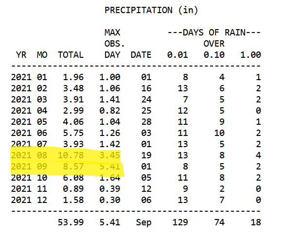
-
E PA/NJ/DE Spring 2023 OBS Thread
Hurricane Agnes replied to Hurricane Agnes's topic in Philadelphia Region
Actually bottomed out at 57, which was a bit cooler this morning than yesterday and I'm off to the races and currently 70, partly sunny with lots of cumulus, and with a dp of 53. El Nino Watch is on after the La Nina 3-peat! -
E PA/NJ/DE Spring 2023 OBS Thread
Hurricane Agnes replied to Hurricane Agnes's topic in Philadelphia Region
Bottomed out at 61 this morning and have just hit 87 with full sun and relatively "low" dp of 53. -
E PA/NJ/DE Spring 2023 OBS Thread
Hurricane Agnes replied to Hurricane Agnes's topic in Philadelphia Region
Looks like I maxed out at 82 today, with blue skies and an active breeze. It's currently 80 and sunny with dp 49. -
E PA/NJ/DE Spring 2023 OBS Thread
Hurricane Agnes replied to Hurricane Agnes's topic in Philadelphia Region
Like the acorns on oak trees, it is usually a result of the previous year's weather and the tree's response to it. The baby pine cones form now and eventually mature in the fall and will fall off during late fall through winter. It is like this every year around this time. It's the brief "dry warmth" before the slop bin humidity hits. I always chuckle about the period from now until maybe mid-May being the perfect time for roofers to do their work without excessive rains and heat. After that... As an obs, I have already surpassed my yesterday's high and am currently mostly sunny and 76 with dp 48. -
E PA/NJ/DE Spring 2023 OBS Thread
Hurricane Agnes replied to Hurricane Agnes's topic in Philadelphia Region
Temp soared to 74 today with an active breeze after a low of 43 and it will only get warmer each day for the remainder of the work week. It did briefly cloudy up during the mid-afternoon but that cleared out for a mostly sunny finish through to sunset. Am currently at 65 with dp 38. -
E PA/NJ/DE Spring 2023 OBS Thread
Hurricane Agnes replied to Hurricane Agnes's topic in Philadelphia Region
Really nice day yesterday and I made it up to 58 for a high. This morning was actually a degree "warmer" for the low of 34 compared to yesterday morning's 33, even with calm conditions maintained through the night and early morning. Temps have recovered however and am now up to 44 with dp 37. -
E PA/NJ/DE Spring 2023 OBS Thread
Hurricane Agnes replied to Hurricane Agnes's topic in Philadelphia Region
Bottomed out at 33 this morning. Interestingly enough, there were some puffs of breeze between 4 am - 6 am that probably disrupted the full radiational cooling before it went calm before 6 am. In any case, the temps recovered quickly and it's currently 53 and sunny with dp 32. -
E PA/NJ/DE Spring 2023 OBS Thread
Hurricane Agnes replied to Hurricane Agnes's topic in Philadelphia Region
Some areas west are dry but not our area - Ended up hitting 59 as a high yesterday and watched the dp slowly drop into the low 20s. It's currently 39 with dp 22. -
E PA/NJ/DE Spring 2023 OBS Thread
Hurricane Agnes replied to Hurricane Agnes's topic in Philadelphia Region
Got up to 82 for a high and only have a measly drought-inducing 0.10" of rain in the bucket so far. Currently 62 with dp 56. -
E PA/NJ/DE Spring 2023 OBS Thread
Hurricane Agnes replied to Hurricane Agnes's topic in Philadelphia Region
You're under a Severe Thunderstorm Watch down there - Eyes on the skies! -
E PA/NJ/DE Spring 2023 OBS Thread
Hurricane Agnes replied to Hurricane Agnes's topic in Philadelphia Region
Well in the meantime it's 81 IMBY at the moment! And that is with dp at 64 so am glad the AC is on because the brick does absorb that warmth. It's possible that the cold front might moderate some. -
E PA/NJ/DE Spring 2023 OBS Thread
Hurricane Agnes replied to Hurricane Agnes's topic in Philadelphia Region
SWDY1 has shifted the area's severe threat further south into the Delmarva - Am currently at my low for the morning - 53, with dp 52 and the sidewalk is wet, so have had some non-measurable something overnight. -
E PA/NJ/DE Spring 2023 OBS Thread
Hurricane Agnes replied to Hurricane Agnes's topic in Philadelphia Region
Had to fire up the central air a couple hours ago to cool it down in here since the fans were useless and I figured that it was a good time to test it out to make sure it was operating okay. The warm front has been wavering in the area and it took a bit to get the temps here into the mid-60s vs yesterday's 77. So far it has gotten as high as 67 after a low of 55 and it's currently partly sunny and 64 with dp 56. -
E PA/NJ/DE Spring 2023 OBS Thread
Hurricane Agnes replied to Hurricane Agnes's topic in Philadelphia Region
SWDY2 has a good chunk of the lower 1/3rd of the CWA under a "Marginal Risk" for severe - I managed to remain mild overnight with a "low" (so far) at 57. Currently overcast (had some low stratus earlier) and 59 with dp 58. -
Time to start tracking t- storm events
Hurricane Agnes replied to Albedoman's topic in Philadelphia Region
SPC SWDY2 has Philly metro, S. Jersey, and all of Delaware in "Marginal Risk" - If the temps do get anywhere near the 80s on Thursday and the cold front manages to generate a significant a strong squall line, then it might get interesting around these parts. -
E PA/NJ/DE Spring 2023 OBS Thread
Hurricane Agnes replied to Hurricane Agnes's topic in Philadelphia Region
Actually ended up hitting 77 for a high and it's currently partly sunny and 72 with dp that has crept up to 60. -
E PA/NJ/DE Spring 2023 OBS Thread
Hurricane Agnes replied to Hurricane Agnes's topic in Philadelphia Region
I was seeing some sites forecasting possible 80s Thursday. Someone busted out a weed whacker too. Now up to 76 with dp 57. Also partly sunny with lots of cumulus!