Hurricane Agnes
-
Posts
9,264 -
Joined
Content Type
Profiles
Blogs
Forums
American Weather
Media Demo
Store
Gallery
Everything posted by Hurricane Agnes
-
E PA/NJ/DE Spring 2022 OBS Thread
Hurricane Agnes replied to Hurricane Agnes's topic in Philadelphia Region
Got a whole 0.01" out of that. Temp did drop though and with slowly clearing skies, I'm down to 57 with dp 51. -
E PA/NJ/DE Spring 2022 OBS Thread
Hurricane Agnes replied to Hurricane Agnes's topic in Philadelphia Region
Last day of April had a low of 42 and high of 67. The month of April ended with 7.33" of rain IMBY. But now with the recent low humidity and gusty winds the past couple days, although the ground is nice and watered, the poor foliage is wanting for some moisture (but a little bit is coming). Had a low of 40 this morning and made it up to 72 for a high as the clouds rolled in. Currently mostly cloudy and 70 with dp 43 and a wide band of rain headed this way. -
E PA/NJ/DE Spring 2022 OBS Thread
Hurricane Agnes replied to Hurricane Agnes's topic in Philadelphia Region
Suffice it to say, I was all over the map today with the winds! I made it up to 62 today and it's still mostly sunny, breezy and 61, with a dp down into the teens at 16, so some arid 17% humidity.
-
E PA/NJ/DE Spring 2022 OBS Thread
Hurricane Agnes replied to Hurricane Agnes's topic in Philadelphia Region
Bottomed out at 38 just after 5 am this morning but temp has recovered fairly quickly. Currently mostly sunny and 50 with dp 21. -
E PA/NJ/DE Spring 2022 OBS Thread
Hurricane Agnes replied to Hurricane Agnes's topic in Philadelphia Region
Freeze Warning lofted all around Philly metro - Also saw that the name "Ida" has now been officially retired by the WMO - I may have hit my high for the day of 56 and it's currently 55 and sunny with dp now down to 17 and with the winds still gusting. -
E PA/NJ/DE Spring 2022 OBS Thread
Hurricane Agnes replied to Hurricane Agnes's topic in Philadelphia Region
Red Flag Warning was lofted - -
E PA/NJ/DE Spring 2022 OBS Thread
Hurricane Agnes replied to Hurricane Agnes's topic in Philadelphia Region
Looks like I may have bottomed out at 36 this morning now that I am posting right around sunrise. Currently mostly cloudy, 37 and very breezy, with a dp of 23. -
E PA/NJ/DE Spring 2022 OBS Thread
Hurricane Agnes replied to Hurricane Agnes's topic in Philadelphia Region
Had a generally unsettled day today although the sun did make some appearances in between the CAA clouds. Had a low of 46 this morning and a high of 56. Currently down to 46 and mostly cloudy with dp down to 31. I did see the Fire Weather Watches have been lofted for Thursday and Friday. -
E PA/NJ/DE Spring 2022 OBS Thread
Hurricane Agnes replied to Hurricane Agnes's topic in Philadelphia Region
Made it up to 61 yesterday and had a low of 53 this morning with some low stratus and generally overcast skies. Sun has popped out now and it's party cloudy and 64 with dp 55. -
E PA/NJ/DE Spring 2022 OBS Thread
Hurricane Agnes replied to Hurricane Agnes's topic in Philadelphia Region
Ended up hitting a high of 64 yesterday and had a low of 50 this morning. Currently a beautiful blue sky and a sunny 70 with low humidity (dp 43). -
E PA/NJ/DE Spring 2022 OBS Thread
Hurricane Agnes replied to Hurricane Agnes's topic in Philadelphia Region
Ended up a bit warmer than progged overnight possibly due to a deck of clouds (that were also present early this morning meaning being unable to look at the heavily-promoted 4-planet alignment with the moon). Low was 53 and it's currently mostly cloudy (although about an hour ago, the clouds had broken up a bit but are back) and 60 with dp 37. -
E PA/NJ/DE Spring 2022 OBS Thread
Hurricane Agnes replied to Hurricane Agnes's topic in Philadelphia Region
All the weather entities have scaled that back to the mid-70s for Sunday. Mt. Holly noted the potential for a marine layer influence along the coast (which would cool temps a bit inland too), plus the position of the ridge might end up pushing the warmer temps up north to the LV area. It did turn out to be a nice day today with low humidity and reasonable temps for an early spring day (plus my early lilac is blooming so it made it through the frosts and freezes after budding up during that cold snap). I made it up to 69 for a high after a low of 45. Currently mostly sunny and 68 with dp 33. -
E PA/NJ/DE Spring 2022 OBS Thread
Hurricane Agnes replied to Hurricane Agnes's topic in Philadelphia Region
Yeah the one thing about fall is that the ground is warm (along with any large bodies of water nearby) so even with chilly cold fronts, the radiation of heat from the ground help neutralize the chill, even during cloudy days. In spring, the ground is still cold (along with those large bodies of water) and you need that sun to help - at least to get some "spot warmth". I got up to 58 today with full sun and some scattered clouds here and there. Currently mostly sunny and 56 with dp 31. -
E PA/NJ/DE Spring 2022 OBS Thread
Hurricane Agnes replied to Hurricane Agnes's topic in Philadelphia Region
Thanks for the reminder! I have seen several announce retirements or moves in the AFDs, including one recently (I think either at the end of last month or beginning of this month). I also think Walt Drag did similar with a move. -
E PA/NJ/DE Spring 2022 OBS Thread
Hurricane Agnes replied to Hurricane Agnes's topic in Philadelphia Region
Yeah I was surprised to see him in that video because I thought he was at Mt. Holly (but then come to think of it, I hadn't seen any AFDs lately by him from Mt. Holly but have seen a few new folks there doing them). -
E PA/NJ/DE Spring 2022 OBS Thread
Hurricane Agnes replied to Hurricane Agnes's topic in Philadelphia Region
Here are their tweets about the records - -
E PA/NJ/DE Spring 2022 OBS Thread
Hurricane Agnes replied to Hurricane Agnes's topic in Philadelphia Region
I was under a brief snow shower mixed with some light rain around 6 pm. No graupel that go-around. Temp here is 46 with dp 31 and continually-changing skies, plus that active breeze. -
E PA/NJ/DE Spring 2022 OBS Thread
Hurricane Agnes replied to Hurricane Agnes's topic in Philadelphia Region
My turn! Getting a rain/graupel mix under one of the popcorn radar returns. Currently 46 with dp 35 with continued changeable skies.
-
E PA/NJ/DE Spring 2022 OBS Thread
Hurricane Agnes replied to Hurricane Agnes's topic in Philadelphia Region
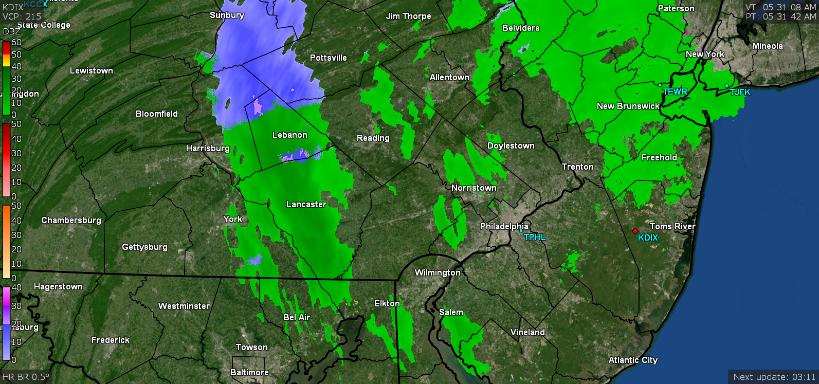
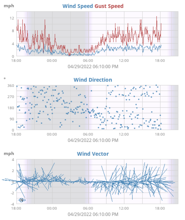
Sun is now popping in and out although there are radar returns still showing overhead. Ended up with the previously posted 0.45" for today (plus 1.69" from yesterday) for a total of 2.14" for the 2 days and 7.21" for the month of April to date. Temp currently 39 with dp 37 with changeable skies including breaks of sun. ETA - I expect the Wissahickon is out of its banks (or close) along the lower lying spots of Lincoln Dr. I had driven along it this past Sunday and it was already relatively high.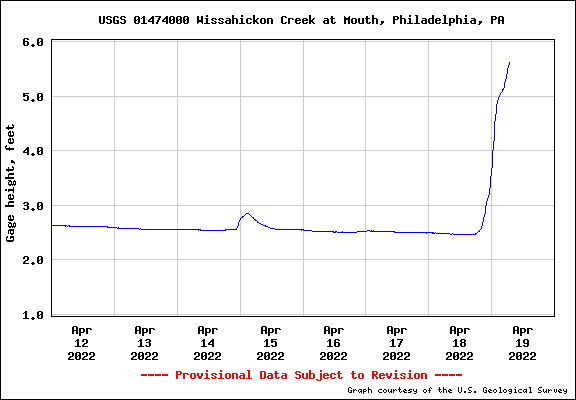
-
E PA/NJ/DE Spring 2022 OBS Thread
Hurricane Agnes replied to Hurricane Agnes's topic in Philadelphia Region
That last wrap-around band is here and is giving me some light precip (got an additional 0.01" so far). Currently have 0.45" for today at post time (2.14" for the 2-day event), with temp at 38 and dp 36.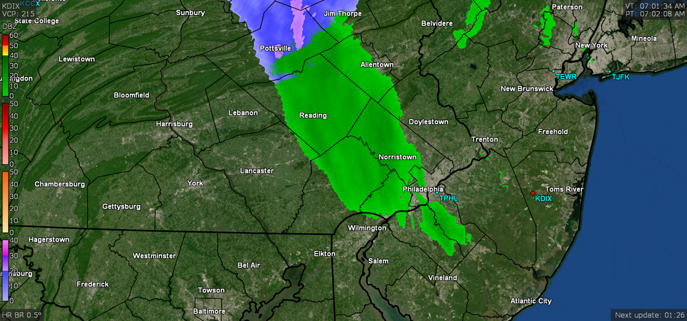
-
E PA/NJ/DE Spring 2022 OBS Thread
Hurricane Agnes replied to Hurricane Agnes's topic in Philadelphia Region
So far ended up with 1.69" yesterday and am at 0.44" this morning for a total of 2.13" for the 2-day event. That makes it a 7.20" rain total for the month of April so far. There looks like there may be one more little wrap-around band left to come through although it might or might produce anything by the time it gets here. Currently misty and 38 with dp 37.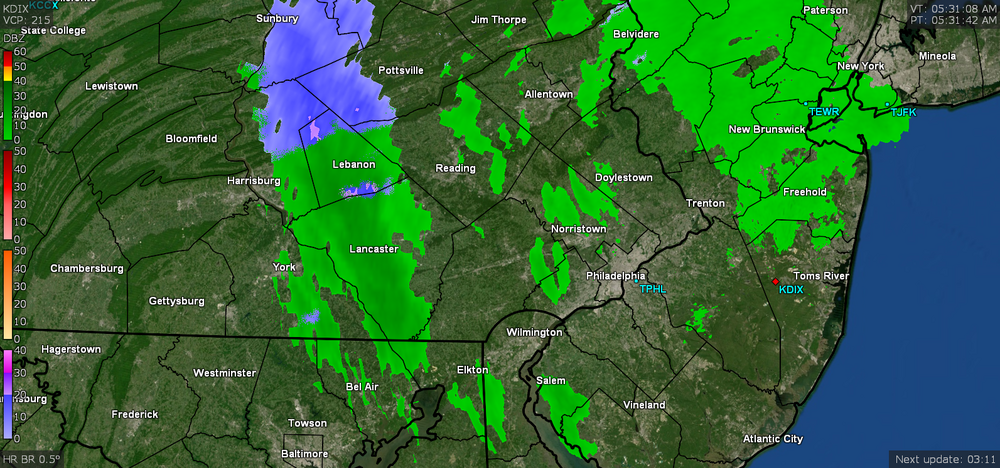
-
E PA/NJ/DE Spring 2022 OBS Thread
Hurricane Agnes replied to Hurricane Agnes's topic in Philadelphia Region
Now have 1.15" in the bucket with ~ 1/4" per hour rates. Currently 42 with dp 41, light - moderate rain, and a stiff breeze. -
E PA/NJ/DE Spring 2022 OBS Thread
Hurricane Agnes replied to Hurricane Agnes's topic in Philadelphia Region
Got scraped by a small heavier band but am currently 42, up to 0.92" of rain so far today, with near 1/2" per hour rates, dp at 41, and increasing winds. -
E PA/NJ/DE Spring 2022 OBS Thread
Hurricane Agnes replied to Hurricane Agnes's topic in Philadelphia Region
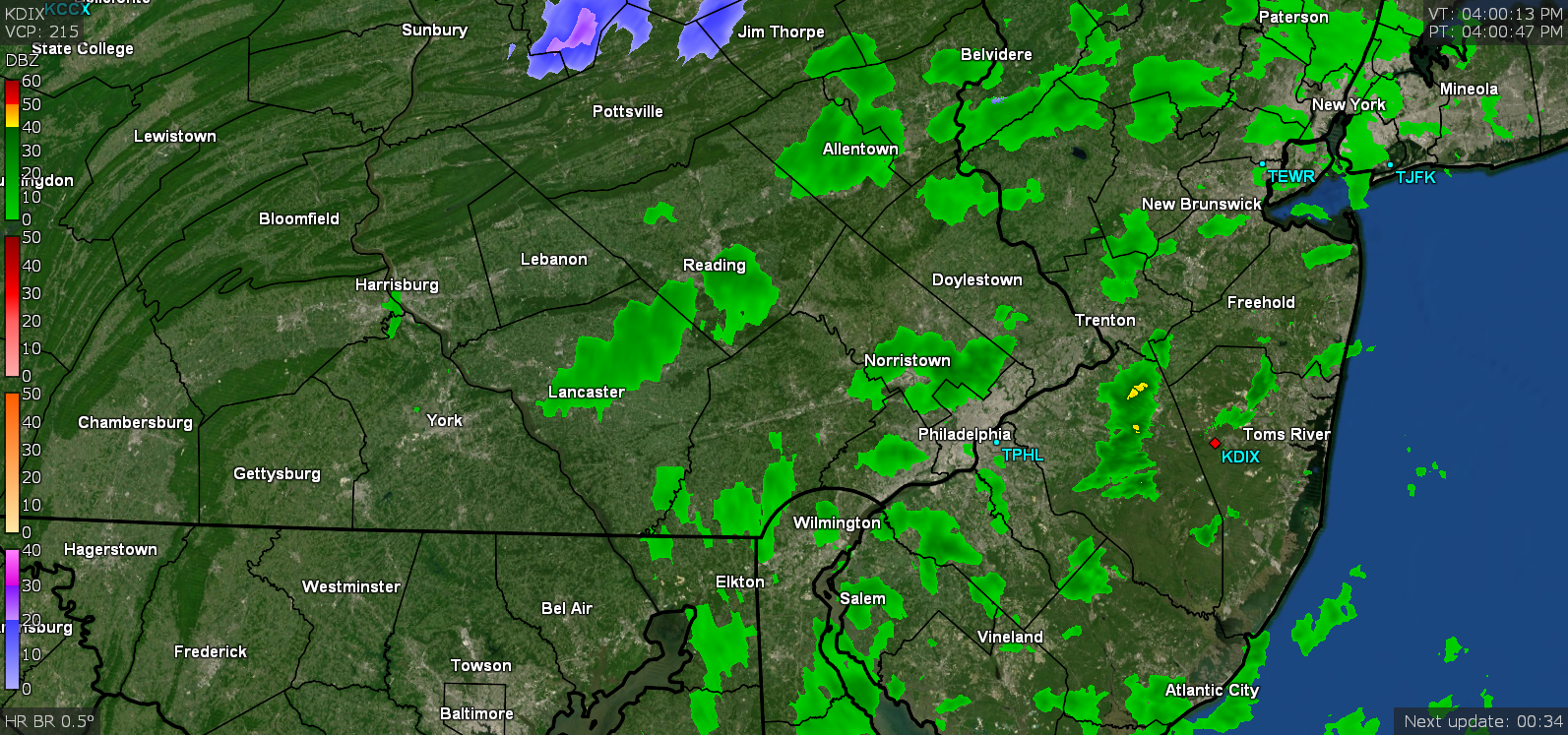
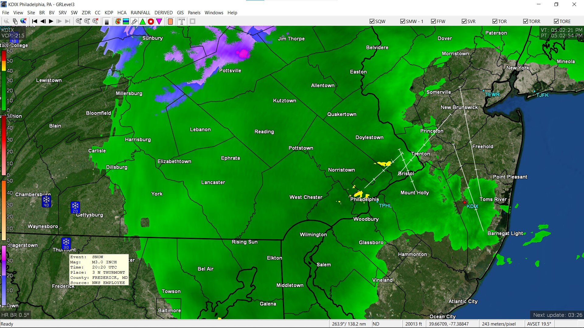
Under a little more more than drizzly rain now and am up to 0.06". I noticed the mPing reports had places like Thurmont (just north of Frederick, MD( reporting 3" of snow! Currently 43 with dp38 and light rain.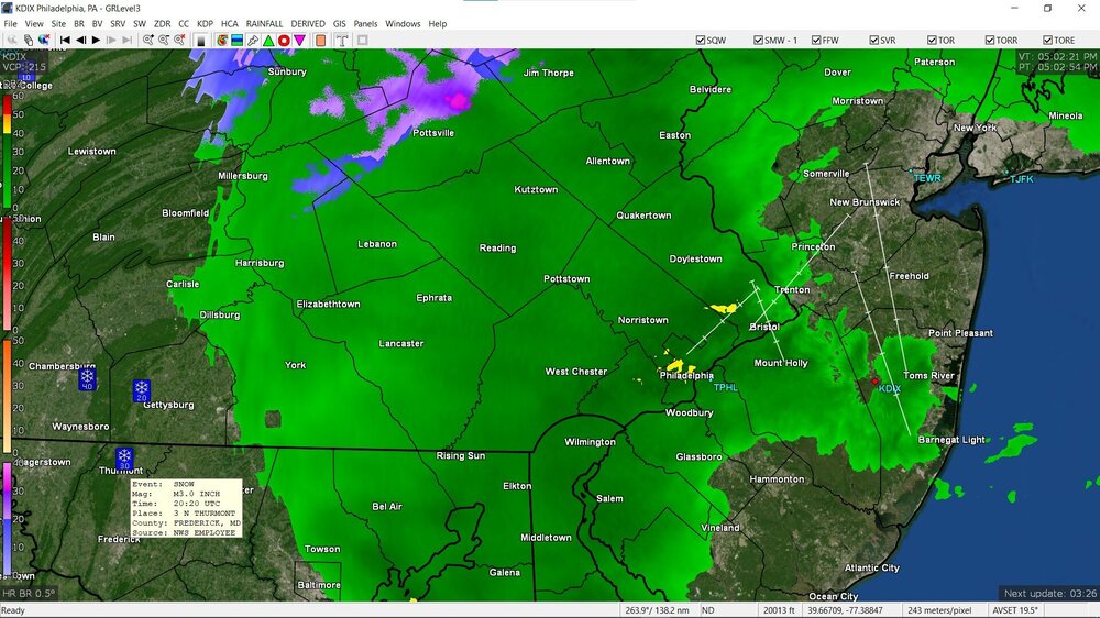
-
E PA/NJ/DE Spring 2022 OBS Thread
Hurricane Agnes replied to Hurricane Agnes's topic in Philadelphia Region
There are a couple upthread (in Chester County & Delaware County PA around the 1pm - 2 pm timeframe).