
Wx 24/7
-
Posts
1,228 -
Joined
-
Last visited
Content Type
Profiles
Blogs
Forums
American Weather
Media Demo
Store
Gallery
Posts posted by Wx 24/7
-
-
Yeah, it is pretty consistent across the board. Not gangbusters in terms of snow, but a wild next 36 hours about to begin to unfold.
-
 1
1
-
-
Perhaps they are like me and have been busily trying to finish their holiday shopping!

I think the HRRR has a nice output this evening. Ignore the WRF!
")
-
 1
1
-
-
Just now, stormdragonwx said:
Looks like models are trending drier and further north again. As it sits I think outside of MO and KS we will see 1" maybe 2" at best.
I can't emphasize enough how much trouble 1" or so of snow, 40 mph winds, and temps dropping to near zero in a matter of hours can cause. This isn't going to be a huge snow, but the impacts are going to be significant.
-
Really quiet in here... morning model runs so no real dramatic changes to my thinking. Did see that the Canadian and EURO want to drop a clipper in on Monday now it appears. Something else to watch...
Oh, to be in the Buffalo, NY area. Crazy winter they have had already!
-
2
-
-
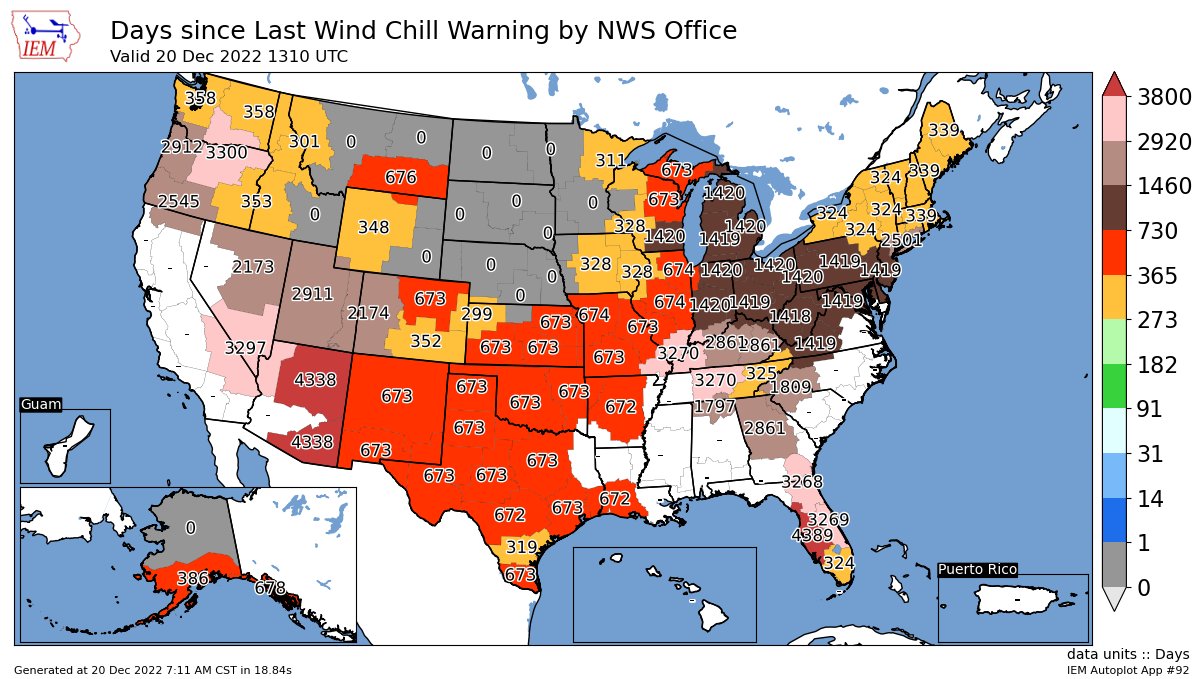
Here's some context as it relates to the rarity of a Wind Chill Warning...
-
 1
1
-
-
....and this is why I don't get the Charlie Brown optimism. That being said... this is still going to be brutal and memorable system. We may not get a bazillion inches of snow, but this type of cold, snow, and wind is pretty rare this far south. The blizzard word does look feasible still.
-
1
-
-
The EURO ensembles seem less impressive to me today.
I am still less than assured that this is a strong setup. Some snow for Christmas would be great. The cold is still looking nuts.
-
06z GFS is much better. HA!
I have been Charlie Browned too many times... I will wait until the snow is on radar before I get too excited.
EURO operational did trend snowier overnight... although it is about in the middle of the ensembles now instead of being the dry outlier.
Wind chills on Thursday are going to be crazy either way... dangerous time for this event with Christmas just a few days later.
-
2
-
-
Yes. The operational model run of the EURO is actually one of the drier (less snowier) solutions of the ensembles.
-
While this storm is definitely not set in stone, you would have to use much higher than 10:1 ratios in much of that snow as the temps crash. Just throwing that out there, too, FWIW.
-
One word describes the Christmas holiday... BRRRRRRRRRRRRRR!
-
Winter time is back. Hey all. Good to be following along again. Still looks like a significant cold snap is on its way next week. The waves that rotate through will work themselves out in the meantime. Don't get hung up too much on run-to-run snowfall numbers. Looks like the first wave arrives Monday. Will be glad when NAM gets in range as it handles arctic air better.
-
1
-
-
MOD risk upgrade in the latest SPC update for NC and NE OK. Probabilities have increased as well, especially on the wind side of things.
-
On 3/11/2022 at 9:51 AM, MUWX said:
Pretty disappointing up this way. Somewhere between a dusting and a half inch.
That's because I was down in Mountain View, AR. I got about 2.5" of snow down there.

-
1
-
-
1 hour ago, MUWX said:
Based on what has happened so far, and what short term models are showing for round 2, I don’t see how this event gets to a WSW level event.
Actually only need 1/2" of sleet apparently to get a WSW. It should meet that criteria.
-
15 minutes ago, thunderbird12 said:
Occasional moderate-to-heavy sleet in Norman this morning. Heard a couple rumbles of thunder as well. It's not often that you get to hear thunder when it's 12 degrees outside.
Indeed! Lightning showing up on my RadarScope in the Bella Vista area as well. Hoping most of this band is sleet or snow. I wouldn't want freezing rain with this wave.
-
Just heard local KY3 met in Springfield say road temps are already in lower 20s so whatever falls is going to coat/glaze/stick to the roads immediately.
-
Sleet and freezing rain is going to be quite a mess. I am especially concerned about NW AR in the major cities of the area on up into far southern MO.
-
2
-
-
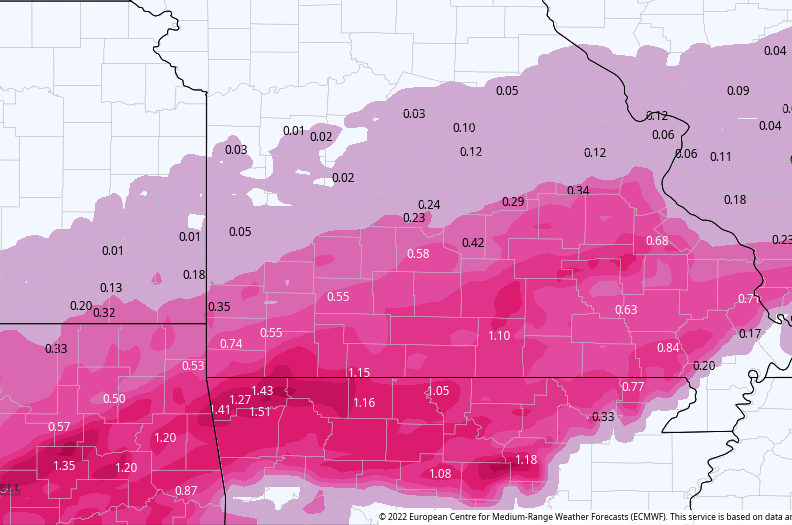
It is quite interesting to me that the NAM has been a bit lighter in terms of precip totals, compared to its normal overzealous precip output. Additionally, it tends to favor more sleet... while the EURO has been very consistent with very intense freezing rain numbers. I hope that the NAM is right. The ice outputs from the EURO are alarming, especially in Northern Arkansas.
-
It is awfully quiet in here.
NWS Little Rock is on board with a Winter Storm Watch.
Springfield seems to be less aggressive at this point.
-
These are not the kind of words you want to hear in an AFD. This came from this morning's in Tulsa:
QuoteSubstantial sleet and freezing rain accumulations remain forecast across much of E OK / NW AR through Wednesday through Thursday. Travel impacts should be anticipated. Power grids are likely to be stressed with the corridor of heaviest freezing rain. Precip types and amounts will continued to be refined. However today will mark the warmest day to complete any early preparations in advance of the winter storm.
-
1
-
-
Agree that most models are in decent agreement that there is a system that bears watching next week and it looks to be very impactful somewhere in the region.
-
1
-
-
This is more of a classic system for us... rain and storms on the front side and a backside wallop of something. I just don't want ice.
-
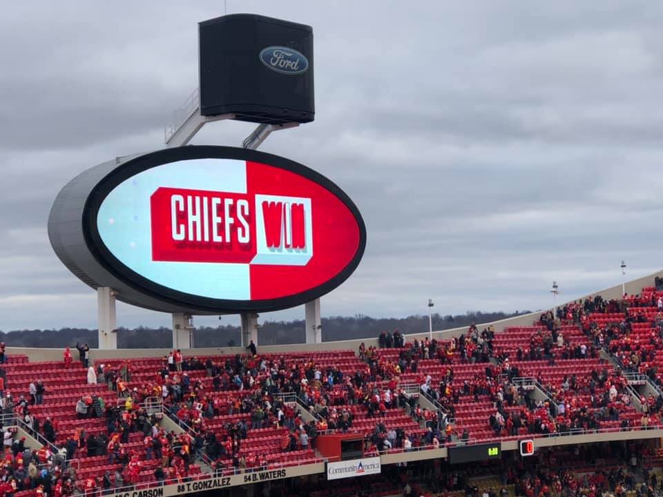
Storm total here ended up being about 7 3/4".
-
1
-
MO/KS/AR/OK 2022-2023 Winter Discussion
in Central/Western States
Posted
Yeah, as the tweet mentions the accumulation estimate should probably be somewhere between 10:1 and the Kuchera. Probably more like 12:1. That being said... the drier snow will still wring out any available moisture. One thing I have been doing is looking at the precip totals and sort of gauging based off that in combination with the snowfall outputs.