TheClimateChanger
-
Posts
4,436 -
Joined
-
Last visited
Content Type
Profiles
Blogs
Forums
American Weather
Media Demo
Store
Gallery
Everything posted by TheClimateChanger
-
Look, I don't want to stir up any trouble. I know you and @CoastalWxare prolific posters with lots of credibility, but MADIS almost also shows a big warm bias. And I'm always skeptical of people making a big deal out of a station running warm. You never see people call out stations running cool - Albany was running 2-3 degrees too low for awhile, it took a former NWS met calling it out before they would address it. It's always so warm these days, that even a minor warm bias automatically gets detected and amplified since records start being shattered.
-
It may have a small warm bias, but MADIS is not reliable. It literally always says most ASOS stations are way too warm. It's certainly not 2 degrees off the surrounding stations - Boston is only 0.7F from a record, Concord 0.5F, and Hartford 0.3F. None of the surrounding first-order sites are any where near 2 degrees cooler than ORH, on a departure basis.
-
Central PA Autumn 2023
TheClimateChanger replied to Itstrainingtime's topic in Upstate New York/Pennsylvania
I see my "alter ego" is lurking. -
Central PA Autumn 2023
TheClimateChanger replied to Itstrainingtime's topic in Upstate New York/Pennsylvania
Bunch of snowflakes in this thread. Can't even take someone sharing the fact that it's been one of the hottest and least snowiest years on record without flying off the handle. Funny, I bet some of these are "free speech" people. -
Central PA Autumn 2023
TheClimateChanger replied to Itstrainingtime's topic in Upstate New York/Pennsylvania
Got to love it! I post topical climate data for central Pennsylvania, don't even mention climate change, and am accused of trolling. @PSUWhiteout70comes here posting completely off-topic conspiracy theories, and gets several likes. -
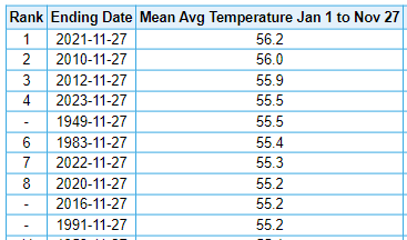
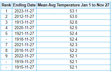
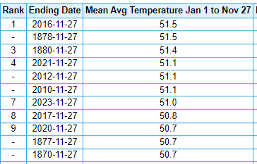
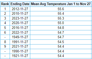
Looking like another historic year weatherwise for New England, depending on how December shapes up. Here is a collection of cities, with 2023 ranging from warmest on record at ORH to 7th warmest on record at CON. Some of the records for ORH and CON in the early years are not reliable - in the case of ORH, this is due mainly to elevation and site location changes. Unclear what the problem is at CON, but the 1870s are way out of whack with other data [excluding those records, 2023 is 5th warmest since 1880]. Burlington, VT Caribou, ME Mount Washington, NH Boston, MA Worcester, MA Note: Due to substantial elevation change, early data is not directly comparable to present. Concord, NH Hartford, CT
-
Central PA Autumn 2023
TheClimateChanger replied to Itstrainingtime's topic in Upstate New York/Pennsylvania
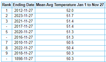
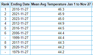
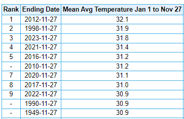
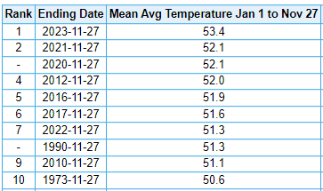
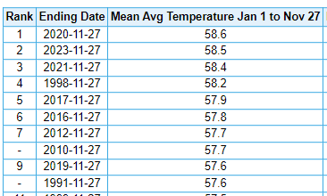
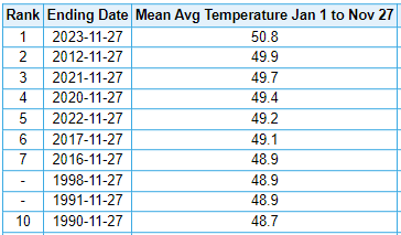
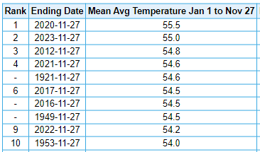
With a little over one month left in the year, 2023 continues to be in the running for one of the warmest years on record at several cities in the Commonwealth of Pennsylvania. Notably, it is easily the warmest on record at DuBois and Bradford, in the higher elevations of the north. Williamsport, Harrisburg, and Scranton/Wilkes-Barre area are all in second place to date - in the latter two cities, the records belong to the recent year of 2020; however, the record at Williamsport dates back more than 100 years (1921). While 1921 is the warmest through November 27, the record warmest year at IPT actually occurred much more recently in 2012 (as a warm December enabled that year to overtake the early 20th century challenger). Regardless, if we continue to run warmer than normal in December, this is shaping up to be an historic year weather-wise in the Commonwealth. I am looking forward, with much excitement, to sharing the final numbers in early January. Williamsport (2nd warmest) DuBois (warmest on record - a full 1.3F above #2!!!) Harrisburg - Middleton (2nd place) Bradford (warmest on record - by nearly a full degree!) Scranton, Wilkes-Barre, Avoca, PA (2nd warmest)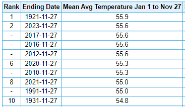
-
Central PA Autumn 2023
TheClimateChanger replied to Itstrainingtime's topic in Upstate New York/Pennsylvania
I just don't know what is so controversial, or factually wrong. Like I said, I was just taking a quick look at snowfall numbers for Pennsylvania cities, as we head into winter. Since I don't live near Harrisburg, I didn't know snowfall has been that low there. While 2019-2020 & 2022-2023 were paltry everywhere in the Commonwealth, most places in the Commonwealth have not had their top two least snowiest winters in that stretch. -
Central PA Autumn 2023
TheClimateChanger replied to Itstrainingtime's topic in Upstate New York/Pennsylvania
I was talking about the sock puppet theory. Wonder if he thinks ChescoWx is another sock puppet of mine? Lol. -
Central PA Autumn 2023
TheClimateChanger replied to Itstrainingtime's topic in Upstate New York/Pennsylvania
Same here. The bulk of my posts are simply sharing unadjusted climate stats from first order sites that I find interesting. I never even bring up climate change, except in the climate change section. -
Central PA Autumn 2023
TheClimateChanger replied to Itstrainingtime's topic in Upstate New York/Pennsylvania
Nobody thinks that, except for you. -
Central PA Autumn 2023
TheClimateChanger replied to Itstrainingtime's topic in Upstate New York/Pennsylvania
With all due respect, how is posting year to date climate statistics for the capital against the rules? -
Central PA Autumn 2023
TheClimateChanger replied to Itstrainingtime's topic in Upstate New York/Pennsylvania
Yes, I posted the annual snowfall to date in the previous post. 2023 is #1 for lowest through 11-27. -
Central PA Autumn 2023
TheClimateChanger replied to Itstrainingtime's topic in Upstate New York/Pennsylvania
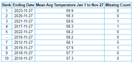
In any event, here is where we stand on the year in the capital city. This has been an incredibly noteworthy year weatherwise. Second warmest to date Least snowiest calendar year to date Just a shame that records aren't taken at Capital City Airport anymore, or we'd really be blowing all other years out of the water. They do this all the time. Move the station to a cooler location to hide the incline. Change the equipment or time of observations to hide the incline. It's just not working anymore.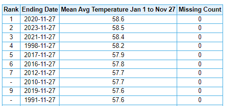
-
Central PA Autumn 2023
TheClimateChanger replied to Itstrainingtime's topic in Upstate New York/Pennsylvania
I'm going to have to disagree. I don't think anyone here knew it was that bad in 2019-2020 & 2022-2023 in Harrisburg. I certainly didn't, as I haven't seen it mentioned anywhere. -
Central PA Autumn 2023
TheClimateChanger replied to Itstrainingtime's topic in Upstate New York/Pennsylvania
I was looking at snowfall records across the Commonwealth, and I found this quite interesting. Harrisburg had never had less than 9" of snow in a full winter until recently, but has now had 2 of the past 4 winters with less than 6 inches of snow. By percent that is pretty substantial, some 35-40% less than the prior record in those winters.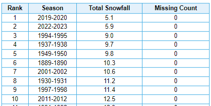
-
Pittsburgh/Western PA Fall 2023 Discussion
TheClimateChanger replied to Ahoff's topic in Upstate New York/Pennsylvania
Picked up a light dusting of snow pellets here. -
Pittsburgh/Western PA Fall 2023 Discussion
TheClimateChanger replied to Ahoff's topic in Upstate New York/Pennsylvania
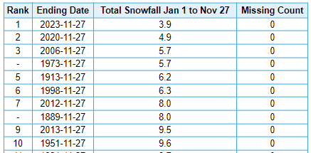
11.6 inches of snow so far in the 2023 calendar year. The least snowiest calendar year on record is 1998, with 10.9 inches. The current second least snowiest calendar year is 1889, with 15.8 inches. However, that value is probably not really comparable to recent snowfall records due to changes in location and station exposure, as well as changes in snowfall measurement procedures. -
Central PA Autumn 2023
TheClimateChanger replied to Itstrainingtime's topic in Upstate New York/Pennsylvania
I guess only one person can possibly wonder how winter will be affected by a 2C warmer globe this year? Even if only temporary, that’s pretty significant since all the discourse has always made it seem that’s some far off threshold. -
Central PA Autumn 2023
TheClimateChanger replied to Itstrainingtime's topic in Upstate New York/Pennsylvania
You would think it would be pretty difficult to get any sustained wintry weather at our latitude in a +2C world. Might have to hold out hope for a few “thread the needle” type events that melt away quickly. -
The sky is literally falling though. https://e360.yale.edu/features/climate-change-upper-atmosphere-cooling#:~:text=it to contract.-,The sky is falling — literally.,at Charles University in Prague.
-
-
Fall 2023 Medium/Long Range Discussion
TheClimateChanger replied to Chicago Storm's topic in Lakes/Ohio Valley
Are the palms still unprotected? -
Central PA Autumn 2023
TheClimateChanger replied to Itstrainingtime's topic in Upstate New York/Pennsylvania
Oh, I didn’t mean to imply your forecast was incorrect. I was admiring your willingness to go out on a limb. I just thought 58” sounded like a lot for IPT, and was curious how long it had been since that number was reached or exceeded in a winter. -
Central PA Autumn 2023
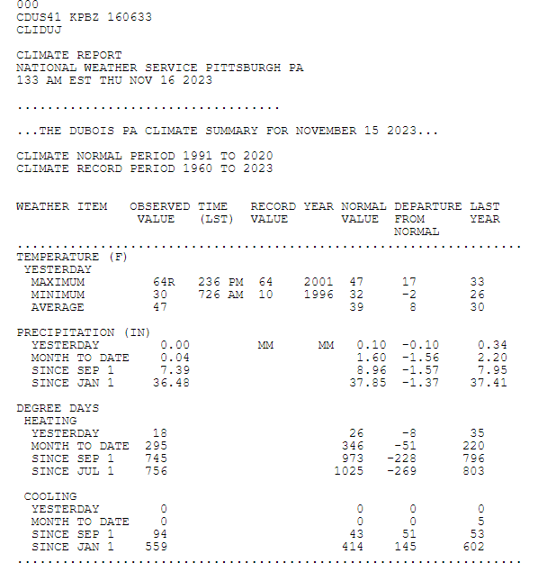
TheClimateChanger replied to Itstrainingtime's topic in Upstate New York/Pennsylvania
Here was Wednesday's climate report for DuBois - Jefferson County Airport. Far cry from last year when the high was just 33.