TheClimateChanger
-
Posts
4,436 -
Joined
-
Last visited
Content Type
Profiles
Blogs
Forums
American Weather
Media Demo
Store
Gallery
Everything posted by TheClimateChanger
-
Pittsburgh, Pa Winter 2023-24 Thread.
TheClimateChanger replied to meatwad's topic in Upstate New York/Pennsylvania
Which run? I was unimpressed by the 12Z which had Pittsburgh at 6.7" and more like 5-6" at KPIT through the entire run. North Carolina gets dumped on though - 22" at Greensboro and a foot at Raleigh-Durham. Edit: Doesn't show the North Carolina event until the 19th-20th, and Pittsburgh is in the upper 30s for highs those days. -
@donsutherland1 Is it possible that some of the 1-3" days in the early years would be 3-6" days under current snow measuring techniques? And similarly some of the 3-6" days (not shown) would have registered as 6"+ days under current snow measuring techniques? This trend might mostly be generally an artifact of data quality issues and actually masking a general decrease in total snowfall. UCAR estimates proper snow board use with 6-hourly measurements can increase reported total snowfall by 15-20 percent relative to a single storm measurement. Moreover, there were other inconsistencies before 1950, including the use of a simple 10:1 ratio for snowfall at some sites and/or simply measuring change in depth (although I don't think this was the case at Central Park). Regardless, snow boards didn't come into use until the latter half of the 20th century. Source: Snowfall measurement: a flaky history | NCAR & UCAR News
-
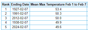
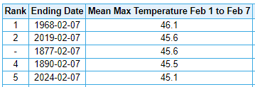
At MSP, this is the warm weather equivalent to 1895, which at -11.7F is the coldest by 3.4F (second place: 1936, -8.3F). Warmest First 7 Days of February Coldest First 7 Days of February


-
Honorable mention shout out to LSE. More than a degree over second place (1878), which itself is nearly SIX degrees warmer than 3rd place.
-
Unbelievable SCORCHING start to the month. The average high at MSP has been more than 4F above any other year over this same 7-day period, and DSM has been nearly 2F above any prior year. Chicago has its warmest first 7 days of February since 1882! Expect eastern sections to climb over the next few days. Many places could see their warmest first 10 days of February on record by average high temperature. Here are some rankings for average high temperature over the first 7 days of February: Minneapolis/St. Paul (1st) Chicago (2nd) Green Bay (2nd) Des Moines (1st) Indianapolis (5th) International Falls (2nd) LaCrosse, WI (1st) Milwaukee (5th) Toledo, OH (5th) Detroit (7th)
-
Central PA Winter 23/24
TheClimateChanger replied to Voyager's topic in Upstate New York/Pennsylvania
Looks like Punxsutawney Phil has been spot-on so far.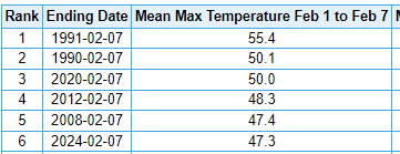
-
Central PA Winter 23/24
TheClimateChanger replied to Voyager's topic in Upstate New York/Pennsylvania
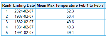
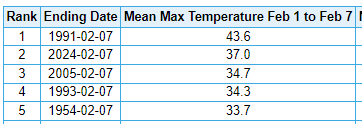
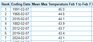
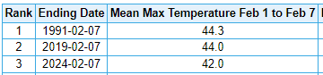
A SCORCHING start to the month of February across central and western Pennsylvania. Rankings for average high temperatures for the first 7 days of the month: Harrisburg/Middleton (6th) Williamsport (3rd) Scranton/Wilkes-Barre Area (8th) DuBois (2nd) Bradford (3rd) Pittsburgh (5th)
-
Pittsburgh, Pa Winter 2023-24 Thread.
TheClimateChanger replied to meatwad's topic in Upstate New York/Pennsylvania
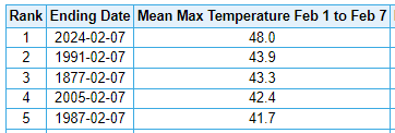
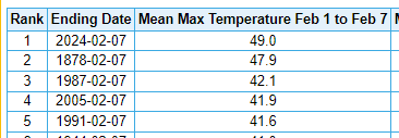
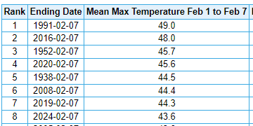
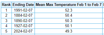
The average high temperature over the first seven days of February (49.3F) has been the fifth highest over 150 years in the threaded record, and exceeded only by 1991 at the airport (52.3F). Given the high temperatures over the next 3 days, I'd say it is likely this will be the warmest first 10 days of February on record by average high temperature.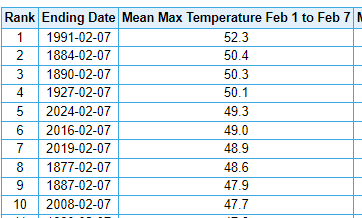
-
Pittsburgh, Pa Winter 2023-24 Thread.
TheClimateChanger replied to meatwad's topic in Upstate New York/Pennsylvania
What’s it look like with Kuchera ratios? Kuchera ratio maps used to throw up massively inflated totals, but I’ve noticed over the past couple of years, they have often been less than the 10:1 maps. -
Pittsburgh, Pa Winter 2023-24 Thread.
TheClimateChanger replied to meatwad's topic in Upstate New York/Pennsylvania
This would be swell. -
Pittsburgh, Pa Winter 2023-24 Thread.
TheClimateChanger replied to meatwad's topic in Upstate New York/Pennsylvania
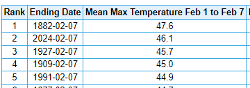
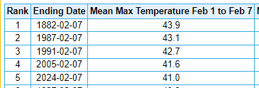
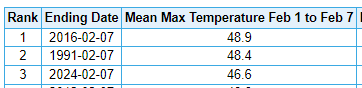
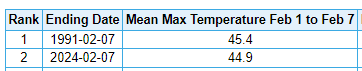
I know most here don't like data, but I had to re-run the numbers through six days of February torch - and it's not pretty. Up to 4th place now, matching the highest of any winter to date since 1931-32 [downtown city office], and a full 2 degrees warmer than any year at KPIT (2016 & 2002). And it looks like the rest of this week will likely be even warmer, especially with overnight lows.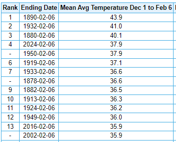
-
Post observation adjustments - appropriate?
TheClimateChanger replied to ChescoWx's topic in Climate Change
Countywide averaging is not an adjustment, though. The countywide average can, in fact, be less than all official observing sites if the observing sites are located generally in warmer locations (low elevation, latitude). The county averages shown by NCEI are still often lower than the official temperatures. The actual adjustments are small and well-justified to eliminate known and recognized biases in the raw data. Berkeley Earth already recreated the warming trend without any explicit adjustments - instead treating variations in the data [when compared to data from surrounding sites] as a new station. Moreover, the U.S. is less than 2% of the earth's surface. Finally, if the warming was all made up from adjustments, then why do satellites, radiosondes, and more recent observations [largely unaffected by these old adjustments] all show strong warming over the past 4-5 decades? If the warming trend was not real, then wouldn't these new tools reveal that the earth really isn't actually warming? But instead, they all show warming - including the UAH satellite data analysis, headed by notable skeptics? Not to mention, warming is evident in physical changes which have been observed - remote sensing of Arctic and Antarctic ice cover, changing plant and animal behavior, etc. -
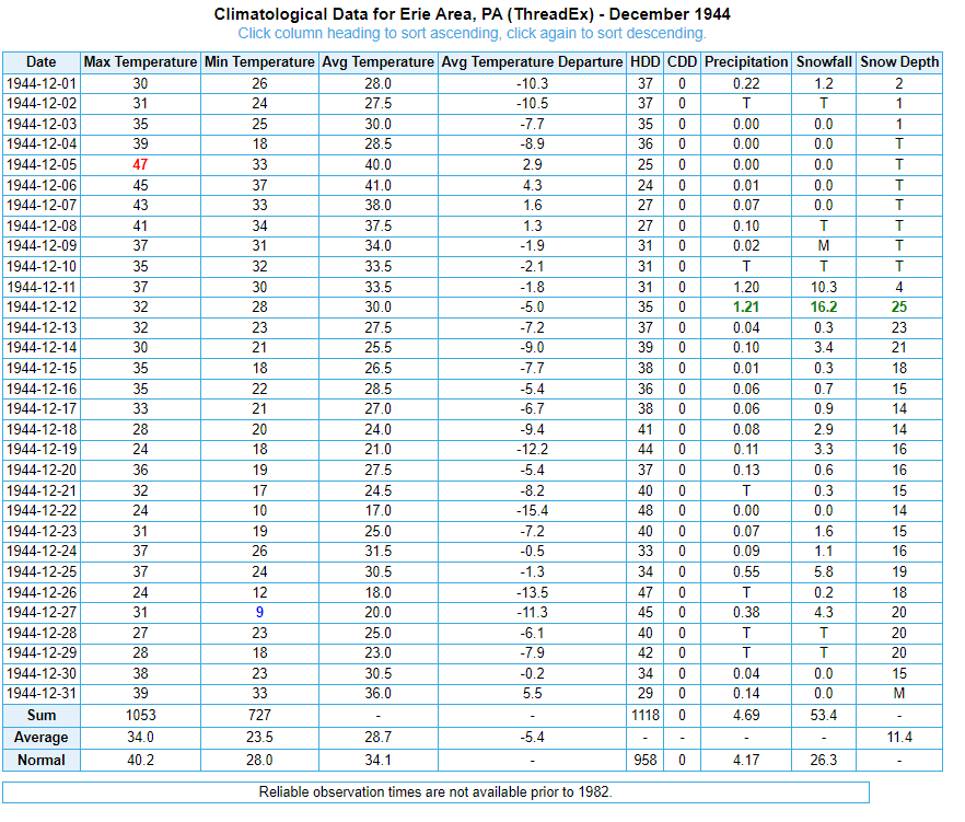
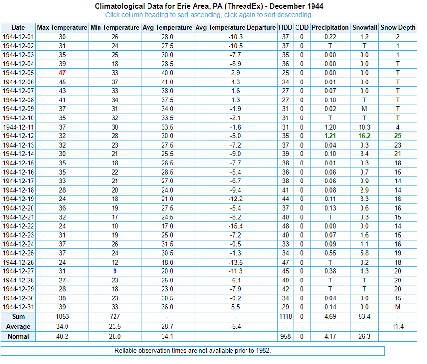
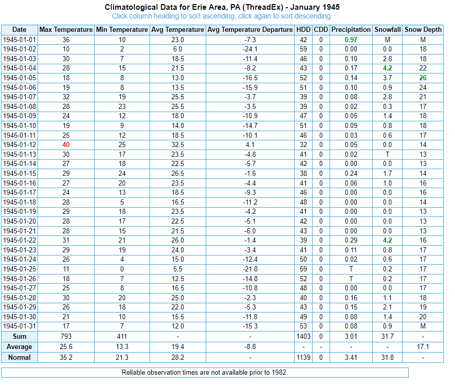
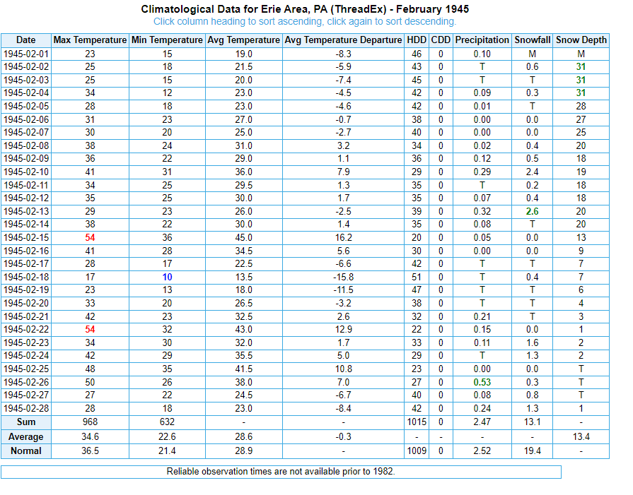
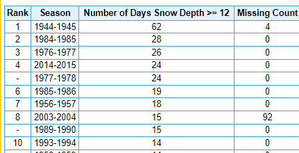
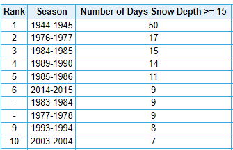
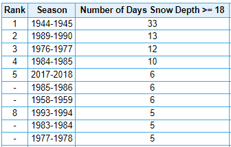
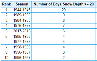
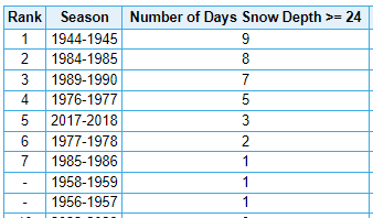
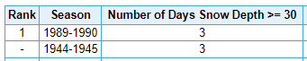
There is no modern winter that comes close to 1944-45, at Erie or Buffalo. Sure, the snowfall amounts, while high, are not record-breaking. But it's clear they weren't measuring with the same diligence that they do today. There were several storms where the depth increased more than the reported snowfall at Erie, including one where depth jumps 9 inches on less than 2 inches of snow. NOTE: 6.6 inches missing from January 1 - should be 38.3 inches on month, per actual records. This is despite missing data on 4 dates. Unfathomable today. The missing numbers are 10" on 12/31, 18" on 1/1, 22" on 1/31 and 31" on 2/1. The bad thing is these numbers probably got flagged due to the bad snowfall figures. No. of days with snow depth of at least 12": 62, per xMacis [actually 65]. 2008-2024, there's been 64. No. of days with snow depth of at least 15": 50, per xMacis [actually 53] - this is more than the next 3 years combined. No. of days with snow depth of at least 18" - there were more of these in 44-45 than there are days of 12"+ in any other winter! [33, per xMacis - actually 36, which is more than the next 3 years combined] No. of days with snow depth of at least 20" [20 per xMacis, actually 22] No. of days with snow depth of at least 24" [9 per xMacis, actually 10] No. of days with snow depth of at least 30" [3 per xMacis, actually 4 - which is more than ALL other years combined]
-
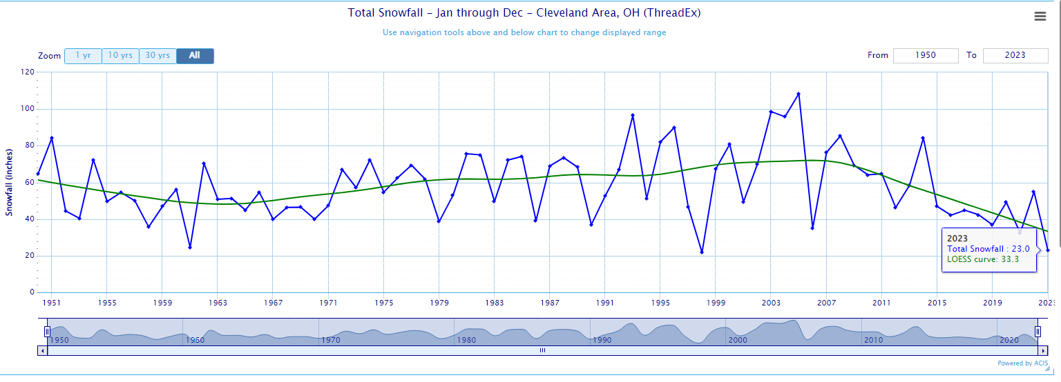
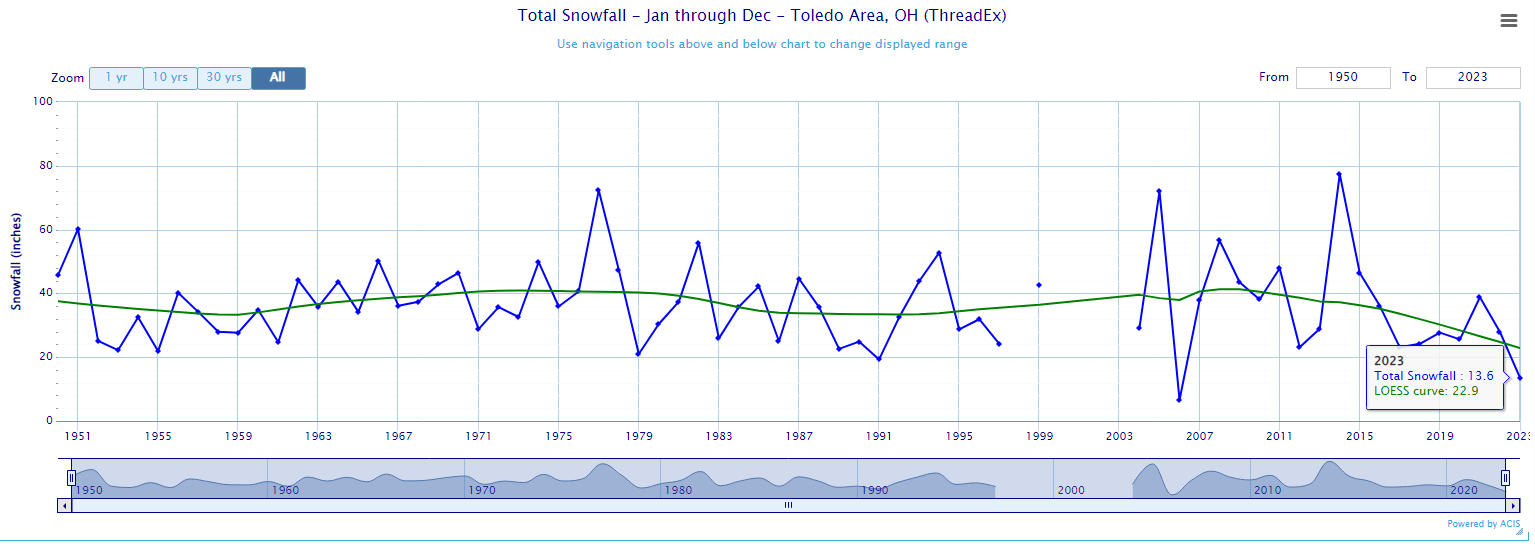
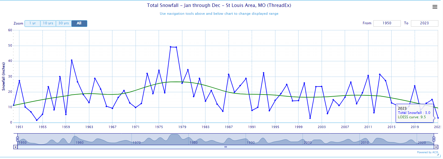
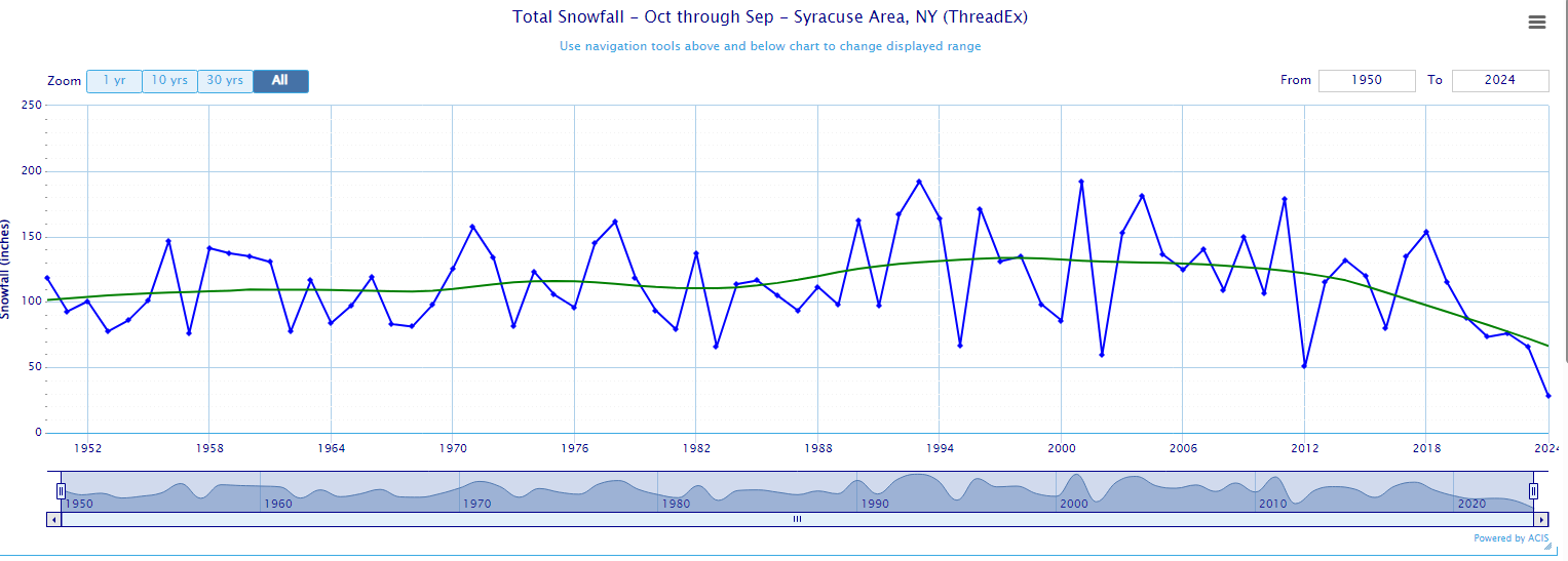
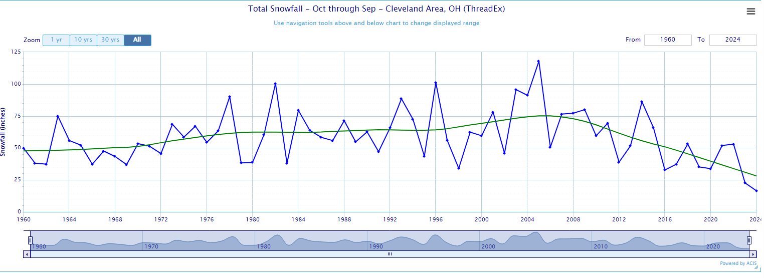
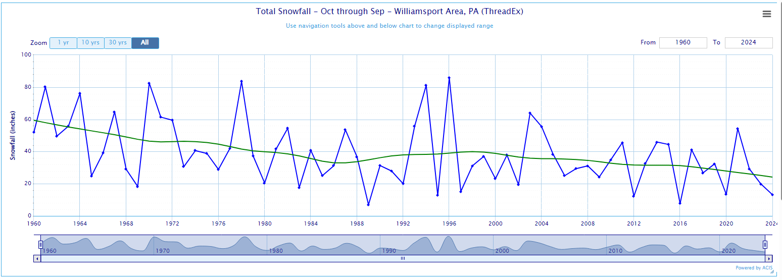
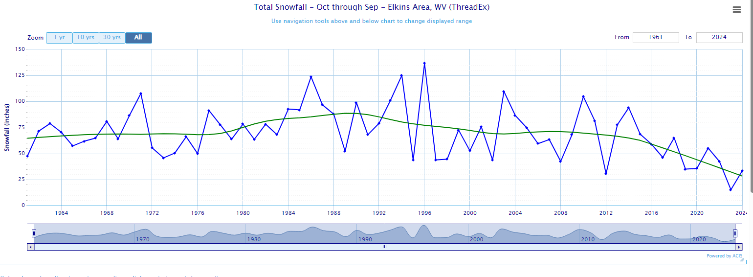
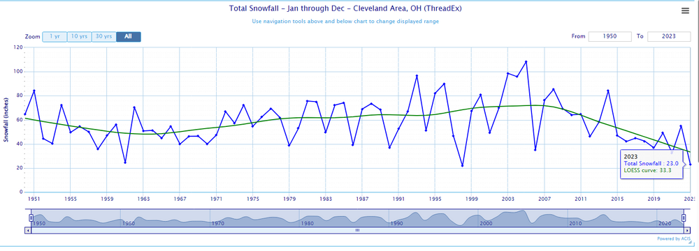
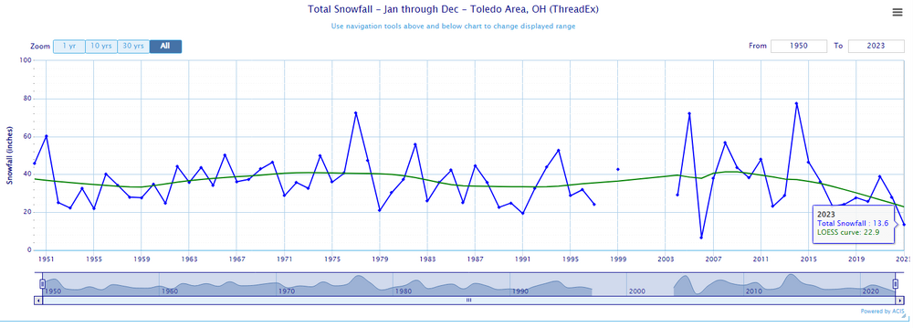
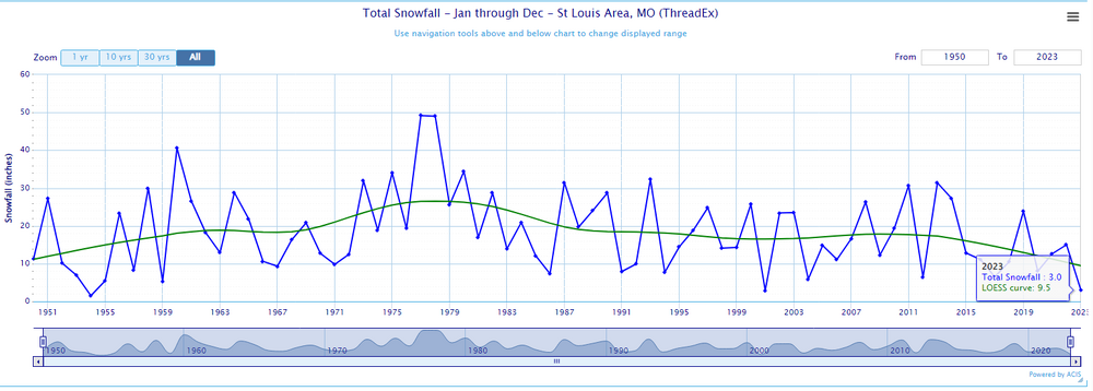
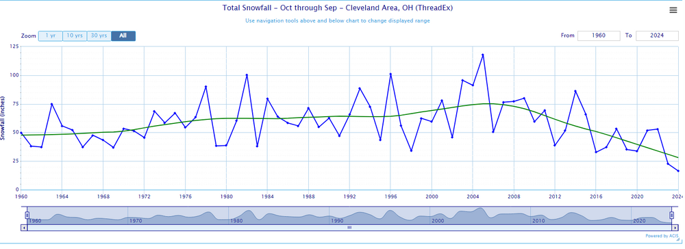
Sorry for off-topic, but it warrants a response. There are plenty of places in the midwest that have seen snowfall drop precipitously over the past decade. Cleveland Columbus Toledo Saint Louis
-
-
The late 1980s to mid 1990s are the steroid era at first order sites: An Investigation of Temperature Discontinuities Introduced by the Installation of the HO-83 Thermometer on JSTOR In Tucson, It's Not the Heat, It's the Thermometers - The New York Times (nytimes.com) Suspect in Record Highs: New Gauge - The New York Times (nytimes.com)
-
Pittsburgh, Pa Winter 2023-24 Thread.
TheClimateChanger replied to meatwad's topic in Upstate New York/Pennsylvania
For the record, I was playing around with the AWSSI last week, and 1997-1998 is the current full-season record low. Last winter appeared to be the second least. It's not a particularly easy tool to find rankings, but I checked several of the dud winters since 1950. It looks like the cold snap just before Christmas prevented last year from being the record low. -
Pittsburgh, Pa Winter 2023-24 Thread.
TheClimateChanger replied to meatwad's topic in Upstate New York/Pennsylvania
-
Part of a long-term trend that really took off in earnest around 2010.
-
I didn’t say anything about 1889-1890 not being warm. The claim was made that there was no urban heat island effect or industrial revolution in that era. All I said was the data would indicate there was a significant urban heat island effect, and my knowledge of history would indicate the industrial revolution was in full swing by that point.
-
It was a Flop... February 2024 Disco. Thread
TheClimateChanger replied to Prismshine Productions's topic in New England
Yeah, that map really isn’t showing that much snow for most places. Normal to below in a lot of places. Just lots of pretty colors because it’s 840 hours. -
Pittsburgh, Pa Winter 2023-24 Thread.
TheClimateChanger replied to meatwad's topic in Upstate New York/Pennsylvania
-
I see no evidence of this in the data. If anything, Detroit used to run more above the surrounding observations in 1890 than it does today. People act like it was some pristine wilderness back then. Detroit already had a population over 200,000, increasing to nearly a million by 1920. The city stations were often sited either on heat-contaminated rooftops, or on heat-contaminated window shelters. And there were large blast furnaces spewing copious amounts of heat and pollution in many of the cities. Furthermore, most of the so-called urban heat island effect is explainable by the fact that cities developed along river valleys and/or lake/coastal Plains, whereas the suburbs and rural areas tend to be situated in elevated upland locations away from these features. Of course, rural/ex-urban White Lake (elev: 1,000'+) is going to be cooler than Detroit (elev: 660 feet). Here's December 1889. Detroit was about 3 degrees warmer than the other two Wayne County sites, 3 degrees warmer than Ann Arbor, and 4 degrees warmer than Ypsilanti. KYIP usually runs warmer than Detroit Metro Wayne Airport, and none of these locations are that much cooler than the airport. There were only 3 warmer locations - Chelsea (Washtenaw), Hanover (Jackson), and Benton Harbor (Berrien). The first two clearly have solar radiation issues, as their high temperatures are WAY out of line with the other sites. Benton Harbor is on the other side of the State.
-
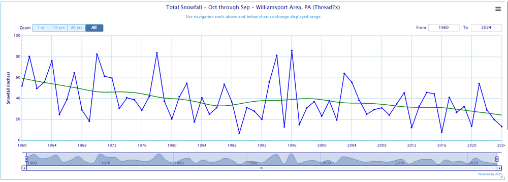
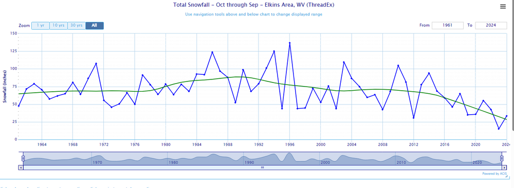
Don, with all due respect, I think the whole planet is in the early stages of a transition toward a lower snowfall regime. Buffalo possibly not included, at least for the time being.
-
I'm wondering if the lack of a cryosphere will moderate any pattern change? I mean there's almost no ice anywhere on the Great Lakes - record breaking lack of ice cover. Even parts of the Upper Peninsula and arrowhead of Minnesota, which ALWAYS have tons of snow, have minimal amounts on the ground. Surely this, coupled with the high sun angle of late February scorching the bare earth, will make it tough to get any meaningful arctic air this far south and east?