

George001
-
Posts
6,887 -
Joined
-
Last visited
Content Type
Profiles
Blogs
Forums
American Weather
Media Demo
Store
Gallery
Everything posted by George001
-
Why not pinch hit for that bum franchy
-
2 runs now Red Sox are actually making this a game
-
About time
-
I got my vaccine so I have already started living my normal life again, and I am not going back. Im not going to wear a mask to protect people who refuse to get vaccinated when they had had plenty of time and easy access to do so.
-
Just get a hit I don’t expect the Red Sox to win this game but at least show some fight cmon
-
Yeah he’s not ready yet. He has a lot of potential but he’s swinging at balls at his eyes right now. That is unacceptable.
-
Thats the type of winter where I nail most of my forecasts.
-
the strength of the La Niña is right now forecasted to be similar to 2017-2018, a high end weak nina, and it is a second year nina as well with increasing solar activity. However, by mid fall that La Niña hadn’t even formed yet, where as this Nina is forecasted to already be borderline moderate by then (like -.8). This is more similar to the progression of the super Nina of 2011 (much weaker in strength but similar in terms of peaking in the fall), that La Niña was already up to -1.6 by September! By December of 2011, the La Niña was still strong and maintained its strength for over 3 straight months. In my opinion this gave the atmosphere enough time to respond to the strong La Niña and allowed the atmospheric pattern to reflect La Niña the entire winter. Looking at the recent ocean temps in the enso region, the enso 3.4 region already is starting to tank, going from +.3 to -.1 over the past 3 weeks. The Pacific Ocean as a whole is starting to cool off as well, with it being a mix of cold and warm unlike last year where it was all warm. That warm blob in the northern pacific is still too far west though, and the sst configuration indicates that although we could see a more favorable pacific jet configuration, the strength of the pacific jet is still stronger than average, so there are some mixed signals for the winter of 2021-2022. I’m not going to issue an official winter forecast until November but right now my early thought on analogs would be 2020-2021 (good match with the fall peaking Nina and increasing solar, North Pacific blob west of ideal) 2017-2018 (good match with the strength of the nina, 2nd year nina, strong pacific jet but slightly more favorable location of North Pacific blob, Nina more east based which this one probably won’t be) 2010-2011 (good match with the fall peaking Nina and increasing solar, more central based like this one, though this Nina was much stronger and the pacific jet was weaker) right now I’m not seeing 1995-1996 as a great analog since I don’t think the pacific will be all that great, but I also think it won’t be as bad as last year, and the nina peaking in the fall as well as the strength should be favorable. I don’t like the pacific blob so far west though, and the Nina is forecasted to be more west based which isn’t ideal. However, the sst configuration on the Atlantic side looks pretty good so we have a good chance at getting more polar vortex intrusions than a garbage winter like 2011-2012. Overall the early signs are mixed but I would say they are more favorable than last year. What do you guys think? My favorite analog is 2017-2018, I think it’s most realistic looking at the early signs. Not a crazy record breaking wall to wall winter like 1995-1996, but still an above average winter even with the lull in mid winter and the warm spells. Way better than 2011-2012 and even about twice as much snow as last year.
-
Yeah 2013-2014 was a good winter but it left a lot on the table in my opinion, we narrowly missed a historic blizzard in late March that year, I remember the models had the strength of the low into the 940s at one point, if that had came up the coast, that would have likely been a widespread 3 footer. Even the severe blizzard in March 2018 that dropped 2 feet of snow where I live got down to the low 960s, just imagine a low in the 940s that is a slow mover coming up the coast! Had that storm hit, that winter would have been up there with the 2014-2015, 2010-2011, 1977-1978, 2004-2005, and 1995-1996 winters.
-
I don’t know how relevant this is but the strength of the La Niña is expected to peak in the fall, not the winter. With the winter of 2017-2018, (this upcoming Nina is forecasted to be similar in strength), the Nina didn’t peak until later. The La Niña hadn’t even formed yet by mid fall in 2017-2018, where as last year we were already at a high end moderate La Niña, 1995-1996 was already borderline moderate, and 2010-2011 was already a strong La Niña. My thought process is that when a La Niña increases in strength throughout the fall, by December whatever lag effect from when the Nina first forms to when the atmosphere responds with a Nina like pattern has already happened by December. This is a big deal for early winter, as I would think a Nina that peaks in the fall by December the Nina is already dominating the pattern, like Dec 2010, Dec 2020, Dec 1995, ect. In early winter, climo is not favorable enough that a purely southern stream system will get it done, that will likely just be a cold rain (like the early dec system last year, the one before the severe blizzard in mid December). You need the northern stream to get involved, otherwise eastern mass will get skunked. A La Niña pattern is more favorable for northern stream interaction leading to more snow NYC north early winter. Therefore my early thoughts are we have a decent shot at an active December with several Miller b blizzards, whether or not that pans out will depend on how the Enso forecast changes, and whether or not we get the polar vortex to cooperate. If the polar vortex goes to the North Pole and sits there the whole winter, it won’t matter what the Enso state is, we will be screwed like 2019-2020 and 2011-2012. Those years both had favorable enso states for New England, but there just wasn’t enough cold with it all being bottled up in the North Pole. If we can get even a little bit of polar vortex cooperation in early December, watch out, we could have Dec 2010 all over again.
-
I remember the winter of 2012-2013 and 2013-14 were both cold neutrals, I would gladly take a repeat of either of those.
-
In recent weeks, the chances that we will have a favorable enso state for New England snow has increased significantly, with the newest guidance, especially the dynamical models shifting from an enso neutral (roughly 0 to -.3 degrees celsius) forecast) to a high end weak la nina (-.8 to -.9 degrees celsius). In my opinion, the shift from a cold neutral to a borderline weak/moderate strength Nina increases the ceiling of the upcoming winter with more northern stream interaction vs a cold neutral, creating more chances for severe Miller b blizzards.
-
It is too warm for a a 2010-2011 super nina type winter, but the subsurface has cooled quite a bit over the past few weeks. Just over a month ago there was talk of a possible weak or even moderate El Niño, but since then the subsurface, hurricane activity, and model guidance have been indicating La Niña. When combined with the tendency for moderate and strong ninas to have a double dip, I wouldn’t rule out a high end moderate or low end strong Nina yet. It is unlikely, but is still within the realm of possibilities. I’m leaning towards a 2017-2018 type of La Niña, both similar in strength and late blooming nature. The biggest red flag that the La Niña could be stronger than expected for me is the strength of the La Niña last year. Last year was a moderate La Niña, but it was a high end moderate/borderline strong Nina. That is the strongest La Niña we have had since the super Nina of 2010-2011. The stronger the first year Nina, the stronger the signal is for a double dip, and it also increases the ceiling of the Nina (usually ends up slightly weaker than the first).
-
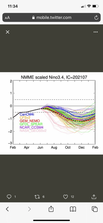
Latest nnme enso forecast for the 2021-2022 winter
-
The most recent guidance has shifted from a cold neutral mean to a high end weak/borderline moderate Nina mean. This will likely have a significant impact on winter forecasts, as model enso forecasts become much more accurate by summer.
-
I haven’t heard of the declining arctic sea ice causing high latitude blocking, if anything I would think low arctic sea ice is an indicator that favors a more mild winter in New England due to a weaker cold air source. The Siberian snow cover thing I do believe has a lot of truth to it, but it’s only one piece of the puzzle. In that 2018 winter we did have a brutal stretch of winter, it wasn’t a garbage winter by any means. It was a 2 week stretch that was really mild, but ended up being a snowier than average winter in the east. Someone who is more knowledgeable about this stuff would be able to explain it better in detail, but based on what I understand is the Hadley cell expansion increases the strength of the pacific jet overall, but that doesn’t mean we can’t get cold stretches, just means the mild stretches will outweigh the cold ones, and over time winters in New England will get less snowy on average. The extreme cold during that same winter occurred during a severe polar vortex intrusion into the United States, which is something that can dominate the pattern. You are right though that a lot of times people oversimplify the atmosphere. During the winter of 2019-2020 I got really excited when I heard there would be a polar vortex split because I assumed that meant New England would get hit by a barrage of severe blizzards, but then I learned what happens when the polar vortex splits to either the west coast instead of the east coast or even the other side of the globe entirely. That is when I learned that polar vortex split doesn’t necessarily mean good for snow, and can even mean the opposite. A lot of indicators that are oversimplified like that. They are still useful when used correctly though.
-
Recently, it has. Some areas reached 80 in feb 2018, Jan 2020, and 70s in Feb 2017. Historically, 80s in New England usually would wait until late April or even well into May, but the Hadley Cell got bigger, and our climate got warmer, and the rate that temps are increasing is accelerating.
-
I’m not super knowledgeable about this stuff, the Meteorologists here would be able to explain in more detail than I can. Based on what I have read though, the Hadley cell sits on both sides of the equator, up to 30N and 30S latitude, and due to climate change, the size of the Hadley cell is increasing. Right now they are predicting that the Hadley cell will expand 2 degrees of latitude on both sides, however historical climate change predictions have underestimated the increasing acceleration of the warming. Due to this it is very possible if not likely that the Hadley cell expands even more than that. If the acceleration in global warming doesn’t stop, in my opinion the Hadley cell will expand enough to engulf the whole planet. This is unlikely to happen in our lifetimes, but still a very real concern that cannot be ignored, as we don’t want to screw over future generations and humanity as a whole. In my opinion the Hadley cell expansion is responsible for the pacific jet blasting the country with mild air, leading to areas as far north as central New England seeing 70+ degree and even 80s in mid winter. 70s and 80s in mid winter was unheard of until a decade or so ago, and it seems like we get a stretch like that at least every other year now. Climate change induced Hadley cell expansion is the most likely culprit for this. If anything I said here is inaccurate, those who are more knowledgeable about this stuff feel free to correct me.
-
The winter of 2018-2019 if anything acted like a super nino, wasn’t that the winter that the pacific jet went ballistic and flooded the country with mild air? The polar vortex didn’t help much but it did come down into the states at times (a bit west of ideal like this most recent winter, but it wasn’t parked over the North Pole like 2011-2012 and 2019-2020). 2018-2019 was forecasted to be an epic winter by many with multiple severe blizzards clobbering New England (understandably, since in November all the seasonal indicators looked really good), but the stronger than expected pacific jet meant we were just too warm, and meant the flow was just too fast so the northern and southern branches mostly stayed separate. Correct me if I’m wrong but isn’t the reason weak ninos are usually so good for New England snow that you get just enough pac jet influence to energize the southern branch enough to increase the ceiling on storms we get, but not quite enough to flood the country with mild air? When you combine an active southern branch with a cooperative polar vortex you get several massive blizzards slamming into New England, producing a widespread 2ft+ of snow with hurricane force winds, like in 2014-2015. Idk if I’m off base here, but for some reason that 2018-2019 winter felt like we were always really close but the lows just kept tracking a bit too far west or we were just a couple degrees too warm to get a big snowstorm, a lot of missed opportunities. Other garbage winters like 2011-2012 and 2019-2020 it felt like we never stood a chance. Honestly, the 2018-2019 pattern wasn’t even terrible even with the raging pacific jet. I feel like that type of pattern with just a slightly more favorable polar vortex as well as a slightly weaker pac jet and we could have had a big winter.
-
This is especially true for stronger ninas. I know going by oni it was considered to be “only” a low end strong Nina, but going my MEI which in my opinion is a better indicator of enso strength, the 2010-2011 winter had the strongest nina on record, the inverse of the 2015-2016 nino). The following winter was a moderate Nina, similar to the strength of last years Nina (maybe a bit weaker). After the strong Nina of 2007-2008, a weak Nina followed. The correlation is not as strong with weak ninas, but after every moderate or stronger Nina on that graph, another Nina followed the next winter. Right now the models are showing a weak Nina next year, but based on last years Enso, the trend from previous months, the spread of the model Enso data (wide range of outcomes, but most of the outliers are to the nina side), and the recent subsurface data, there is potential for the strength of the la nina to drastically increase. Just a couple of months ago, the subsurface was indicating that we could be headed into a moderate el nino, but the subsurface has significantly weakened since then, indicating that the transition to la nina is already starting. Right now I would rule out an El Niño of any strength based on what I’m seeing from the latest data and would lean towards a high end weak nina, and wouldnt yet rule out a moderate, or even low end strong nina.
-
A weak west based nino is ideal, but if all the models were showing that right now the risk would be that the nino strengthens more than expected and the warmer waters move east. Last year all the models were showing a weak Nina at this time, and it ended up being a high end moderate/ borderline strong Nina. Im glad the models are showing a borderline weak Nina/cold neutral right now. Weak Nina is the 2nd best Enso state+strength combination there is. With a Nina you are less likely to get a historic blizzard with 3 feet plus in all of New England (due to less southern stream), but you will have more shots at snow with an active northern stream. If the polar vortex cooperates and you can get the northern branch to dig, go negatively tilted, allowing it to tap and throw Atlantic moisture back into New England, watch out. That is a weather pattern that can and does produce multiple severe blizzards in one year, like 18+ inches with isolated 2 feet. That’s how you get 2010-2011, 1995-1996, and March 2018. Yeah the ceiling isn’t quite as high for individual storms, but you can still get a 2 ft severe blizzard with a northern stream driven Miller b in New England.
-
Good, 5 months ago the way the subsurface looked it appeared like the early signs were indicating we could go mod-strong nino, which means congrats mid atlantic. It appears now the models are leaning towards a weak Nina, which is much better for winter prospects in New England than a moderate or stronger Nino.
-
Due to the unusual climate change induced jet stream configuration currently in place, everywhere from Seattle to Canada to eastern mass is seeing temps soar to the triple digits. In my opinion, the extreme warmth off the northwest pacific is the culprit here. This warm pool allowed the pacific jet to strengthen to levels never seen before, flooding the entire country with hot pacific air. The heat wave we just had? This is only the beginning, according to the models there are signs that warm air is going to start rebuilding by the 2nd week of July. Since this current have happened in June, the next one will be deeper into the summer, and the pacific jet is forecasted to be even stronger. I doubt today will be the last time Boston breaks 100 this year, in my opinion temps will soar to 105-110 in the Boston area during the July 13-23rd timeframe, and it will be climate change induced. Many areas in Washington and Oregon broke all time record temps by 8-10 degrees and it isn’t even mid summer yet. This suggests that the rate of acceleration of global warming has drastically increased. I hate heat, and hope that we don’t see 100 again any time soon, but unfortunately that’s what the long range guidance is telling me right now. I strongly believe that this anomalous weather pattern we are currently in will set the stage for a winter that will smash records. Whether it’s record warmth, snow, cold, or lack of snow, I’m not sure yet. Right now I am leaning mild, due to what we are seeing so far this summer from the jet stream, but things can change very quickly.
-
My original idea back in March of a record strong Nina the next winter might end up right after all the way the models are trending.
-
Off topic but man I just heard about James today, man that’s awful, he was too young. I’m new to posting on this board but I have been lurking on weather boards for years and his posts really stood out to me. His unwavering passion for weather despite getting skunked year after year on the Cape was a beautiful thing. I really wish I could have met him in person, whenever I would hear him hyping up a massive blizzard on the models it made my day. Reading James posts is what lead me to discovering my own passion for weather, and his posts are what inspired me to make an account. I know due to my extreme weeniesm and at times bordering on delusional forecasts lead many to crown me as the biggest weenie on the board, but I refuse to accept that title. James always has and always will be the biggest weenie on this board. RIP James, the man who helped me and many others discover our passions for the weather. Tracking winter storms won’t be the same without him, and next time I’m hyping up a massive blizzard I will always be thinking of him.


