

Mount Joy Snowman
-
Posts
4,984 -
Joined
-
Last visited
Content Type
Profiles
Blogs
Forums
American Weather
Media Demo
Store
Gallery
Everything posted by Mount Joy Snowman
-

Central PA Autumn 2024
Mount Joy Snowman replied to Itstrainingtime's topic in Upstate New York/Pennsylvania
Low of 39 here with a house temp of 62, still no heat! Like others, we also saw the northern lights last night, as my wife snapped a few good pics. I was surprised at how fleeting they were, had to catch it at just the right time. Taking the boat out for the last time this afternoon before she gets wrapped for the winter, gonna be a chilly one on the water. -
Central PA Autumn 2024
Mount Joy Snowman replied to Itstrainingtime's topic in Upstate New York/Pennsylvania
41 when I left this morning. House holding strong at 65. No heat yet. What’s that? A McDonalds breakfast and a train ride? Don’t mind if I do. -
Central PA Autumn 2024
Mount Joy Snowman replied to Itstrainingtime's topic in Upstate New York/Pennsylvania
48 when I left the house. The next couple of nights may cause some to turn on the heat for the first time. I’ll try and resist but the wife and kids will make it hard. Weekend looks splendid. -
Central PA Autumn 2024
Mount Joy Snowman replied to Itstrainingtime's topic in Upstate New York/Pennsylvania
Low of 46. Broke out the fall jacket for the first time this morning. Beautiful week ahead. -
Central PA Autumn 2024
Mount Joy Snowman replied to Itstrainingtime's topic in Upstate New York/Pennsylvania
Low of 58 with .01" of rain. I'm going to put my mower deck back to normal height and get in another mow this afternoon. Beautiful Fall week ahead with nice cool temps and then it looks like we might get a shot of some real-deal cold air for next week. All eyes on Milton. -
Central PA Autumn 2024
Mount Joy Snowman replied to Itstrainingtime's topic in Upstate New York/Pennsylvania
Low of 47. We were out early tailgating yesterday and I was able to snap this beautiful pic of a fog covered Beaver Stadium with the sun rising in the background. What a perfect day.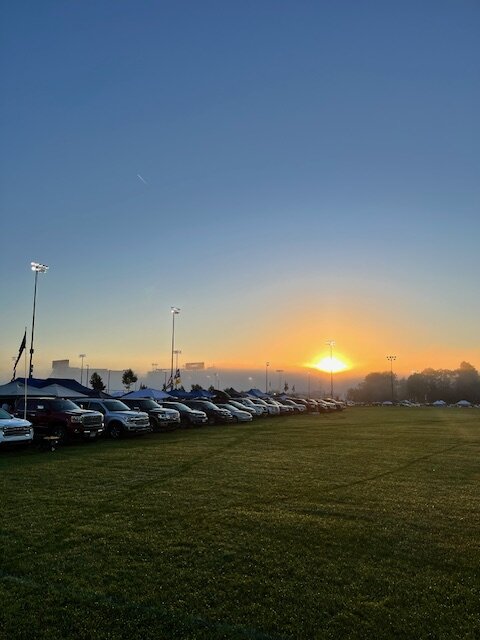
-
Central PA Autumn 2024
Mount Joy Snowman replied to Itstrainingtime's topic in Upstate New York/Pennsylvania
Feels great up here in State College! Up early for tailgating, night boys. -
Central PA Autumn 2024
Mount Joy Snowman replied to Itstrainingtime's topic in Upstate New York/Pennsylvania
Low of 56. Like others, I’ll be raising the deck on the mower today and trying to sneak one in before departing for Penn State. Perfect weekend on tap. -
Central PA Autumn 2024
Mount Joy Snowman replied to Itstrainingtime's topic in Upstate New York/Pennsylvania
Haha well you won't find me. I'll be at a tailgate somewhere off in Lot 12. -
Central PA Autumn 2024
Mount Joy Snowman replied to Itstrainingtime's topic in Upstate New York/Pennsylvania
Low of 59 and no new rain. I totaled 2.44" during this overcast stretch. My YTD stands at 34.04". I'm heading to Happy Valley this weekend for the UCLA game where it should be absolutely beautiful. Some interesting depictions on the models, with the cold shot next week and then the GFS wanting to go ham with a ULL the following week. Fun times ahead. Sorry to the O's and Braves fans out there. -
Central PA Autumn 2024
Mount Joy Snowman replied to Itstrainingtime's topic in Upstate New York/Pennsylvania
Low of 60 and .01” of rain. -
Central PA Autumn 2024
Mount Joy Snowman replied to Itstrainingtime's topic in Upstate New York/Pennsylvania
I wish. .4 miles, that's what I have to endure upon exiting the Amtrak station in Harrisburg. -
Central PA Autumn 2024
Mount Joy Snowman replied to Itstrainingtime's topic in Upstate New York/Pennsylvania
What a persistent blob that's just been hanging over the Harrisburg area. That was not a fun walk into work this morning. -
Central PA Autumn 2024
Mount Joy Snowman replied to Itstrainingtime's topic in Upstate New York/Pennsylvania
Low of 59 and .05” of rain. -
Central PA Autumn 2024
Mount Joy Snowman replied to Itstrainingtime's topic in Upstate New York/Pennsylvania
An absolute travesty that he’s not in the Hall. A hill I will die on. R.I.P. to the Hit King -
Central PA Autumn 2024
Mount Joy Snowman replied to Itstrainingtime's topic in Upstate New York/Pennsylvania
Funny you mention this, my wife recently hooked up an extra TV we have in our garage (primarily to get rid of me on occasion when Penn State or Green Bay play ha) and I was out there on Saturday watching some pigskin when sure enough, I hear a couple of crickets singing their incessant tunes. -
Central PA Autumn 2024
Mount Joy Snowman replied to Itstrainingtime's topic in Upstate New York/Pennsylvania
R.I.P Mt. Mutombo. Gone too young. -
Central PA Autumn 2024
Mount Joy Snowman replied to Itstrainingtime's topic in Upstate New York/Pennsylvania
Low of 60 with .41" of rainfall, making for 2.38" over the last nine days. Count me among those who were surprised at how bountiful and overcast this stretch has been. One day we'll see the sun again, one day. Thursday maybe seems like the ticket. Man, the grass will go ballistic when that day comes. -
Central PA Autumn 2024
Mount Joy Snowman replied to Itstrainingtime's topic in Upstate New York/Pennsylvania
Best player on the team, an absolute horse. -
Central PA Autumn 2024
Mount Joy Snowman replied to Itstrainingtime's topic in Upstate New York/Pennsylvania
Low of 62 with .02” of rain. Penn State was a bit frustrating to watch but ultimately did what they had to do. Same problems persist in that the passing game just isn’t good enough to win at an elite level. Bama Georgia was absolutely drunk. -
Central PA Autumn 2024
Mount Joy Snowman replied to Itstrainingtime's topic in Upstate New York/Pennsylvania
Low of 64 and .15” of additional rainfall. -
Central PA Autumn 2024
Mount Joy Snowman replied to Itstrainingtime's topic in Upstate New York/Pennsylvania
I wonder if this is why my P&C forecast keeps looking infinitely worse ha -
Central PA Autumn 2024
Mount Joy Snowman replied to Itstrainingtime's topic in Upstate New York/Pennsylvania
Indeed, these warm overnight lows here towards the end of the month are going to ruin our BN month, probably end up about a half degree AN now. Low of 68 here with .37" of additional rainfall, up to 1.8" since Saturday. Anyone come across any cool clips from the hurricane? I haven't seen much. I guess landfalling across a very rural area didn't hurt? -
Central PA Autumn 2024
Mount Joy Snowman replied to Itstrainingtime's topic in Upstate New York/Pennsylvania
It's dumping here. -
Central PA Autumn 2024
Mount Joy Snowman replied to Itstrainingtime's topic in Upstate New York/Pennsylvania
They've had their moments over the years but certainly aren't known as one of the powerhouse wrestling schools out that way.


