

Mount Joy Snowman
-
Posts
4,957 -
Joined
-
Last visited
Content Type
Profiles
Blogs
Forums
American Weather
Media Demo
Store
Gallery
Everything posted by Mount Joy Snowman
-

Central PA Winter 25/26 Discussion and Obs
Mount Joy Snowman replied to MAG5035's topic in Upstate New York/Pennsylvania
Low of 43 with about a half inch of rain. Not a morsel of snow to be found. -
Central PA Winter 25/26 Discussion and Obs
Mount Joy Snowman replied to MAG5035's topic in Upstate New York/Pennsylvania
Virginia Tech? -
Central PA Winter 25/26 Discussion and Obs
Mount Joy Snowman replied to MAG5035's topic in Upstate New York/Pennsylvania
Haha believe me, I strongly considered not engaging at all. The points you make are exactly correct, and why I made my post. His entire post just felt strange to me. -
Central PA Winter 25/26 Discussion and Obs
Mount Joy Snowman replied to MAG5035's topic in Upstate New York/Pennsylvania
I mean maaaaybe, perhaps, possibly, mayhaps......but not really. For me personally, no I do not even remotely consider 1 or 2 days in the low 50s in mid-December to be a "torch period". I would also point out that he forecasts for the LSV, not Maine haha, and I assume the people to whom he was responding were also inquiring about the local area, not Canada. I digress. -
Central PA Winter 25/26 Discussion and Obs
Mount Joy Snowman replied to MAG5035's topic in Upstate New York/Pennsylvania
Thought this was a curious post by MU. Is he implying that one day in the low 50s qualifies as a “torch period”? I know he loves his warm weather but it seemed weirdly defensive to me and wasn’t sure who he was addressing.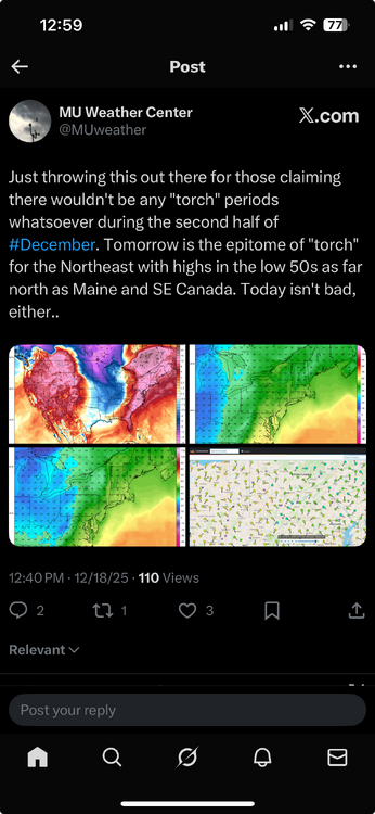
-
Central PA Winter 25/26 Discussion and Obs
Mount Joy Snowman replied to MAG5035's topic in Upstate New York/Pennsylvania
Low of 26. Going to enjoy my last day of full snow coverage before the heavy rains hit tonight. Still a beautiful scene out there. Quite a memorable start to December. -
Central PA Winter 25/26 Discussion and Obs
Mount Joy Snowman replied to MAG5035's topic in Upstate New York/Pennsylvania
Low of 21 but 28 when I left the house. Warm front pushing through it seems. -
Central PA Winter 25/26 Discussion and Obs
Mount Joy Snowman replied to MAG5035's topic in Upstate New York/Pennsylvania
Not that I've ever seen. Last night was about as close as I've ever seen it get, which is part of the reason I posted it. Maybe one day. -
Central PA Winter 25/26 Discussion and Obs
Mount Joy Snowman replied to MAG5035's topic in Upstate New York/Pennsylvania
THV hit -1. National low was only -8 at Presque Isle, ME. -
Central PA Winter 25/26 Discussion and Obs
Mount Joy Snowman replied to MAG5035's topic in Upstate New York/Pennsylvania
10 when I left the house but hit 1 on the car therm through the rurals. Also .2” of daily snowfall. -
Central PA Winter 25/26 Discussion and Obs
Mount Joy Snowman replied to MAG5035's topic in Upstate New York/Pennsylvania
Oh wow nice. Not nearly that much here but you could see it diminishing quickly on the radar as it worked its way east so not surprising. -
Central PA Winter 25/26 Discussion and Obs
Mount Joy Snowman replied to MAG5035's topic in Upstate New York/Pennsylvania
A beautiful light snowfall occurring as I sit at 20 degrees. Nothing better than unexpected snow. -
Central PA Winter 25/26 Discussion and Obs
Mount Joy Snowman replied to MAG5035's topic in Upstate New York/Pennsylvania
Alright, so when do we get the shirtless @sauss06 pics? -
Central PA Winter 25/26 Discussion and Obs
Mount Joy Snowman replied to MAG5035's topic in Upstate New York/Pennsylvania
Low of 14. Winter, it is here. -
Central PA Winter 25/26 Discussion and Obs
Mount Joy Snowman replied to MAG5035's topic in Upstate New York/Pennsylvania
I second this haha. We have a couple, how shall I say, “characters” on the board these days. They need to learn how to assimilate. -
Central PA Winter 25/26 Discussion and Obs
Mount Joy Snowman replied to MAG5035's topic in Upstate New York/Pennsylvania
My 3.3” of snowfall melted down to .28” liquid. Temp has dropped to 25 here. Quite the winter day on tap. -
Central PA Winter 25/26 Discussion and Obs
Mount Joy Snowman replied to MAG5035's topic in Upstate New York/Pennsylvania
Well, I managed to hit the Over, as 3.3” fell here at KMJS. Beautiful scene out there due to the sticky nature of the snow. Current temp of 27 is the low. I’ll melt down and report back later on qpf. A nice little event for most of us! -
Central PA Winter 25/26 Discussion and Obs
Mount Joy Snowman replied to MAG5035's topic in Upstate New York/Pennsylvania
We are well under way here at KMJS. Temp 33 and dropping. All surfaces lightly frosted. Feeling good about how things are developing. Good luck to all! -
Central PA Winter 25/26 Discussion and Obs
Mount Joy Snowman replied to MAG5035's topic in Upstate New York/Pennsylvania
Nothing better than an event that starts with low expectations and then ramps up towards game time. Might have to up my O/U to 3”. -
Central PA Winter 25/26 Discussion and Obs
Mount Joy Snowman replied to MAG5035's topic in Upstate New York/Pennsylvania
Low of 22. I’m setting the Over/Under at 2” for KMJS tonight. I think I go a smidge over. Looking forward to seeing flakes fly tonight. Cheers to everyone! -
Central PA Winter 25/26 Discussion and Obs
Mount Joy Snowman replied to MAG5035's topic in Upstate New York/Pennsylvania
Only because I haven't seen it posted yet...... -
Central PA Winter 25/26 Discussion and Obs
Mount Joy Snowman replied to MAG5035's topic in Upstate New York/Pennsylvania
Great post and so true. I would emphasize that the first half or three quarters of the pack goes a LOT quicker than the last part due to heavy compaction resulting from lower density. I've seen countless times where that last 4-6" hangs on way longer than you'd expect due to the extremely dense icy nature of the pack. As you alluded to, sleet mixed in helps greatly but also the pack itself creates its own icy center due to the daily melt and refreeze cycle. I know you know all this; I just love this topic ha. -
Central PA Winter 25/26 Discussion and Obs
Mount Joy Snowman replied to MAG5035's topic in Upstate New York/Pennsylvania
Yes I know, just interjecting myself into someone else’s conversation haha. Just wanted to reiterate how close the two cabins were. All good. Also, some stray flurries flying here. The kids are excited ha. -
Central PA Winter 25/26 Discussion and Obs
Mount Joy Snowman replied to MAG5035's topic in Upstate New York/Pennsylvania
Low of 22. Liking the potential for Saturday night. December looking like it could be a tale of two halves. -
Central PA Winter 25/26 Discussion and Obs
Mount Joy Snowman replied to MAG5035's topic in Upstate New York/Pennsylvania
I know we've hashed this out before, but my buddy's place is a little under 4 miles east of the Tioga/Potter border and a little over 3 miles SSE of Gaines, close to 2,000'.


