

Mount Joy Snowman
-
Posts
4,984 -
Joined
-
Last visited
Content Type
Profiles
Blogs
Forums
American Weather
Media Demo
Store
Gallery
Everything posted by Mount Joy Snowman
-

Central PA Winter 25/26 Discussion and Obs
Mount Joy Snowman replied to MAG5035's topic in Upstate New York/Pennsylvania
You and everyone else haha. Your post with the skew-t was spot on, how so many people just look at the 850 and 700 panels and assume they're good when it's always that layer in between that gets us. So aggravating for us southeasterners, always fighting it. -
Central PA Winter 25/26 Discussion and Obs
Mount Joy Snowman replied to MAG5035's topic in Upstate New York/Pennsylvania
GFS mostly holds serve but does bring the sleet line a wee bit further north. It's that 800-750mb layer that always kills us. Need the big thump before any worries arrive. -
Central PA Winter 25/26 Discussion and Obs
Mount Joy Snowman replied to MAG5035's topic in Upstate New York/Pennsylvania
18z ICON slightly north with the mixing as well, but only a marginal reduction in totals. -
Central PA Winter 25/26 Discussion and Obs
Mount Joy Snowman replied to MAG5035's topic in Upstate New York/Pennsylvania
We sure have, which is why I never totally rule it out, but it had panels where it was literally showing the thermals colder and further south on all levels yet showing the sleet line further north. Bizarre. -
Central PA Winter 25/26 Discussion and Obs
Mount Joy Snowman replied to MAG5035's topic in Upstate New York/Pennsylvania
You know it's interesting, the NAM run was looking colder and slightly better at all levels during the early part of the run when it's in its prime range but then kind of fell apart later in the run in ways that didn't make sense. I'm not buying it and think by 12z tomorrow it mostly looks like the others. We hope. -
Central PA Winter 25/26 Discussion and Obs
Mount Joy Snowman replied to MAG5035's topic in Upstate New York/Pennsylvania
-
Central PA Winter 25/26 Discussion and Obs
Mount Joy Snowman replied to MAG5035's topic in Upstate New York/Pennsylvania
Latest RRFS also throws the sleet well up into PA unlike its 12z run and reduces totals accordingly. Not buying any of this yet but man. -
Central PA Winter 25/26 Discussion and Obs
Mount Joy Snowman replied to MAG5035's topic in Upstate New York/Pennsylvania
It's a substantial drop from 12z but it's also likely wrong haha. If not.....whew boy. -
Central PA Winter 25/26 Discussion and Obs
Mount Joy Snowman replied to MAG5035's topic in Upstate New York/Pennsylvania
By 7pm NAM has sleet line up into Northumberland County, extreme southern tier is taint from 1pm on. Holding the line for itself ha. I'll give it until 0z to course correct. -
Central PA Winter 25/26 Discussion and Obs
Mount Joy Snowman replied to MAG5035's topic in Upstate New York/Pennsylvania
MU is in….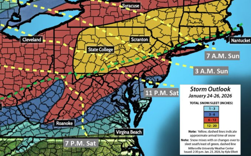
-
Central PA Winter 25/26 Discussion and Obs
Mount Joy Snowman replied to MAG5035's topic in Upstate New York/Pennsylvania
18z NAM looks a touch colder through 30. Keep it coming. -
Central PA Winter 25/26 Discussion and Obs
Mount Joy Snowman replied to MAG5035's topic in Upstate New York/Pennsylvania
18z HRRR at the end of its run at 1pm on Sunday, with roughly 7-9" on the ground. -
Central PA Winter 25/26 Discussion and Obs
Mount Joy Snowman replied to MAG5035's topic in Upstate New York/Pennsylvania
I believe the one and only model we haven't mentioned is the good 'ol RAP haha. Here is the 15z at the end of its run at 1pm on Sunday with the cold seemingly winning out and 6-8" already on the ground. -
Central PA Winter 25/26 Discussion and Obs
Mount Joy Snowman replied to MAG5035's topic in Upstate New York/Pennsylvania
Almost forgot: RRFS - Sleet barely enters Y/L late afternoon but is beaten back, 12-15" totals. Tonight and tomorrow's runs will be very telling with regard to any warm air intrusion between 850 and 700mb, but I am liking the general trends and leaning towards the colder solutions winning out. -
Central PA Winter 25/26 Discussion and Obs
Mount Joy Snowman replied to MAG5035's topic in Upstate New York/Pennsylvania
For those southern tier folks who are interested, I compiled a sleet summary of the 12z short-range models: NAM - Sleet encroaching by early afternoon and fully through southern tier counties by 7pm but gets beaten back a bit, a true battle zone. 6-15" range of totals across Lanc. NAM 3K - Ends run at 7pm Sun but has sleet well into York/Lanc the entire afternoon. The worst depiction of the lot for us. RDPS - Sleet starts entering Y/L by 1pm and completely overtakes by 7pm but still throws down Kuch of 9-13". FV3 - Run ends at 7pm with sleet line still south of PA border and already 12-15" on the ground. ARW - Run ends at 7am Sun but looked mostly good, with sleet line running through central VA. NSL - Run ends at 7am Sun but looked mostly good, with sleet line running through northern VA. HRRR - Run ends at 7am Sun but looked mostly good, with sleet line running through central VA. Anxiously awaiting 18z run. -
Central PA Winter 25/26 Discussion and Obs
Mount Joy Snowman replied to MAG5035's topic in Upstate New York/Pennsylvania
Euro pushes sleet line well up into York/Lanc by 7pm but only after most the precip has fallen. 10:1 below.... -
Central PA Winter 25/26 Discussion and Obs
Mount Joy Snowman replied to MAG5035's topic in Upstate New York/Pennsylvania
Haha no worries. I’ve just been running kids around all morning while trying to look at models and post during breaks. Just forgot to respond. No reason, I just love elevation and figured you had a bit on your side out that way, as I know it climbs pretty decent over there behind CXY. Makes a difference around here. I’m one of those guys who can just stare at topographic maps and be completely entertained for hours ha. -
Central PA Winter 25/26 Discussion and Obs
Mount Joy Snowman replied to MAG5035's topic in Upstate New York/Pennsylvania
I don't believe the RRFS was posted. Keeps the sleet line right along the southern Lancaster tier during the height of the storm but never quite infiltrates, would be perfect verbatim. -
Central PA Winter 25/26 Discussion and Obs
Mount Joy Snowman replied to MAG5035's topic in Upstate New York/Pennsylvania
FV3 still snowing heavily and has sleet line south of PA at 7pm. -
Central PA Winter 25/26 Discussion and Obs
Mount Joy Snowman replied to MAG5035's topic in Upstate New York/Pennsylvania
ICON holds steady. -
Central PA Winter 25/26 Discussion and Obs
Mount Joy Snowman replied to MAG5035's topic in Upstate New York/Pennsylvania
Snow totals for our region are worlds better on NAM when compared to 6z. 3K not quite as friendly with the sleet reductions but getting there. On to the next one. -
Central PA Winter 25/26 Discussion and Obs
Mount Joy Snowman replied to MAG5035's topic in Upstate New York/Pennsylvania
Primary doesn't reach the latitude that it did on 6z. Still taints but not as aggressively. Baby steps for the NAM, good to see. -
Central PA Winter 25/26 Discussion and Obs
Mount Joy Snowman replied to MAG5035's topic in Upstate New York/Pennsylvania
Low of 26. Just got done perusing the 0z/6z model suite and overall pretty solid. I will say, in the aggregate, the mean sleet line seems to reach almost directly over my area by late Sunday afternoon, with the NAM obviously being the most aggressive. Luckily most of the qpf will have occurred by then and the loss shouldn't be too great. We'll have to see if the NAM scores another coup or course corrects to something in between itself and the GFS. I will be keeping a close eye on the Meso's as they come into range today. 12z HRRR just wrapped up and looks good at the end of the run but hard to make much of it at this point. Next 24 hours critical for the MD line folks with regard to sleet impact. Either way, a major storm the likes of which we haven't seen in years is on the way, with deep cold to follow, and perhaps other opportunities thereafter. We've been cold since November so who knows maybe this will be the winter that won't quit. Buckle up friends. -
Central PA Winter 25/26 Discussion and Obs
Mount Joy Snowman replied to MAG5035's topic in Upstate New York/Pennsylvania
I had noticed this a few times this week, just how well LNS was doing in the low department. Snow cover baby. Love it. -
Central PA Winter 25/26 Discussion and Obs
Mount Joy Snowman replied to MAG5035's topic in Upstate New York/Pennsylvania
What’s your elevation over there?


