Mount Joy Snowman
-
Posts
4,964 -
Joined
-
Last visited
Content Type
Profiles
Blogs
Forums
American Weather
Media Demo
Store
Gallery
Everything posted by Mount Joy Snowman
-

Central PA Spring 2022
Mount Joy Snowman replied to Itstrainingtime's topic in Upstate New York/Pennsylvania
Agreed. I mean, take July for instance, where a huge chunk of the month averages damn near 87 for a high. I'm supposed to get excited about the fact that three days are three degrees above average? Do we have a name for when it hits 40 three days in a row in January haha. All a bit silly in my mind. Threshold needs to be higher. -
Central PA Spring 2022
Mount Joy Snowman replied to Itstrainingtime's topic in Upstate New York/Pennsylvania
Wow that's crazy. I ended with 5.98". -
Central PA Spring 2022
Mount Joy Snowman replied to Itstrainingtime's topic in Upstate New York/Pennsylvania
But it's all relative, just departures from their own norms, so unless something has changed with the Susky or the Stoga versus the prior few decades, it shouldn't matter. And yes I know that your post was mostly made in jest haha, but I can't help but think about these things. The perils of being a weather junkie. -
Central PA Spring 2022
Mount Joy Snowman replied to Itstrainingtime's topic in Upstate New York/Pennsylvania
MU often finishes more above normal than MDT does, not sure why that is. -
Central PA Spring 2022
Mount Joy Snowman replied to Itstrainingtime's topic in Upstate New York/Pennsylvania
I'll be selling, not buying, but you're welcome to make the 90 minute trek from R-ville to West Hempfield Township to see it all first-hand -
Central PA Spring 2022
Mount Joy Snowman replied to Itstrainingtime's topic in Upstate New York/Pennsylvania
Indeed. Neighborhood yard sale on Saturday so this works out well. -
Central PA Spring 2022
Mount Joy Snowman replied to Itstrainingtime's topic in Upstate New York/Pennsylvania
MDT ended May with a hefty 6.67" of rain and a temp anomaly 1.9 degrees above average. Looks like some rogue cells around this afternoon before a more widespread threat late tomorrow. Beautiful weekend on tap. -
Central PA Spring 2022
Mount Joy Snowman replied to Itstrainingtime's topic in Upstate New York/Pennsylvania
Not a drop here yesterday, ‘twas gorgeous. Comfy low of 55 and now the real heat builds. EF1 confirmed in southern Lancaster County. Have a great Memorial Day everyone! -
Central PA Spring 2022
Mount Joy Snowman replied to Itstrainingtime's topic in Upstate New York/Pennsylvania
Update: not as much as I would have thought. Added just .16” overnight, for a daily total of .45”. I’ll take it. Low of 62. Should be a mostly glorious Memorial Day weekend. -
Central PA Spring 2022
Mount Joy Snowman replied to Itstrainingtime's topic in Upstate New York/Pennsylvania
You are correct, heard lots of action throughout the night. Unable to check the gauge at the moment, as I am currently stuck on the couch with the toddler watching Blippi. Update forthcoming. -
Central PA Spring 2022
Mount Joy Snowman replied to Itstrainingtime's topic in Upstate New York/Pennsylvania
Garden variety stuff here. Underwhelming from both a wind and a qpf standpoint. A little under .3” in the gauge. -
Central PA Spring 2022
Mount Joy Snowman replied to Itstrainingtime's topic in Upstate New York/Pennsylvania
So par for the course is what you're saying ha. But in all seriousness, it looks like almost everyone should be in for a nice line of heavy showers around lunchtime today. -
Central PA Spring 2022
Mount Joy Snowman replied to Itstrainingtime's topic in Upstate New York/Pennsylvania
Yep. MDT set back to back min max records of 52 and 56. The 52 beat the previous record by five degrees. -
Central PA Spring 2022
Mount Joy Snowman replied to Itstrainingtime's topic in Upstate New York/Pennsylvania
A trace of rain yesterday and a low of 52 last night. Today should be the pick of the litter for the week. -
Central PA Spring 2022
Mount Joy Snowman replied to Itstrainingtime's topic in Upstate New York/Pennsylvania
A low of 58, .01" of rain, and a much-too-early wakeup from the two year old. A nice cool overcast week on tap, before what looks to be a more seasonable Memorial Day weekend. Onward. -
Central PA Spring 2022
Mount Joy Snowman replied to Itstrainingtime's topic in Upstate New York/Pennsylvania
Round one yesterday brought me virtually nothing rain-wise but did provide what were probably my strongest wind gusts of the year. Round two gave a nice quick soaking to the tune of .35". Low of 55 last night. Looking forward to this cooler stretch. -
Central PA Spring 2022
Mount Joy Snowman replied to Itstrainingtime's topic in Upstate New York/Pennsylvania
Low of 70 here. No rain. -
Central PA Spring 2022
Mount Joy Snowman replied to Itstrainingtime's topic in Upstate New York/Pennsylvania
Briefly touched 93 as the high here. -
Central PA Spring 2022
Mount Joy Snowman replied to Itstrainingtime's topic in Upstate New York/Pennsylvania
Well at least I got you on round three, my one and only round. Looks like about .45” over here, all in under 15 minutes. It was really pounding, with some nice wind gusts too. -
Central PA Spring 2022
Mount Joy Snowman replied to Itstrainingtime's topic in Upstate New York/Pennsylvania
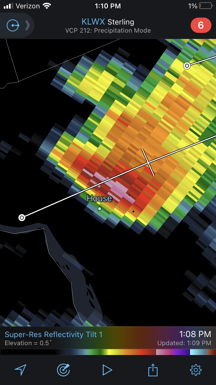
somehow I got nothing from this. Fringed for a third time today! Unreal.
-
Central PA Spring 2022
Mount Joy Snowman replied to Itstrainingtime's topic in Upstate New York/Pennsylvania
And again fringed here, just some more scattered drops. Literally meters from the orange on the radar. -
Central PA Spring 2022
Mount Joy Snowman replied to Itstrainingtime's topic in Upstate New York/Pennsylvania
Nope, believe it or not I got fringed, just a couple of minutes of scattered drops. I was actually outside working on the deck and could see the worst of it just to the north over mount joy. Looks like it split the gap between us, not easy to do ha. Another potent little cell heading our way from york. Wasn’t expecting all this early action, albeit quite isolated. -
Central PA Spring 2022
Mount Joy Snowman replied to Itstrainingtime's topic in Upstate New York/Pennsylvania
Low of 55 here and some light showers currently moving through. -
Central PA Spring 2022
Mount Joy Snowman replied to Itstrainingtime's topic in Upstate New York/Pennsylvania
Hit 79 here today. Now cometh the heat. -
Central PA Spring 2022
Mount Joy Snowman replied to Itstrainingtime's topic in Upstate New York/Pennsylvania
Looking at the records for this weekend, I think we have a good shot at breaking the max min records for 5/21 and 5/22, currently at 68 and 69, respectively. Additionally, perhaps a decent shot at the record high of 95 for Saturday and an outside shot at the record 96 for Sunday.