

WolfStock1
-
Posts
239 -
Joined
-
Last visited
Content Type
Profiles
Blogs
Forums
American Weather
Media Demo
Store
Gallery
Everything posted by WolfStock1
-
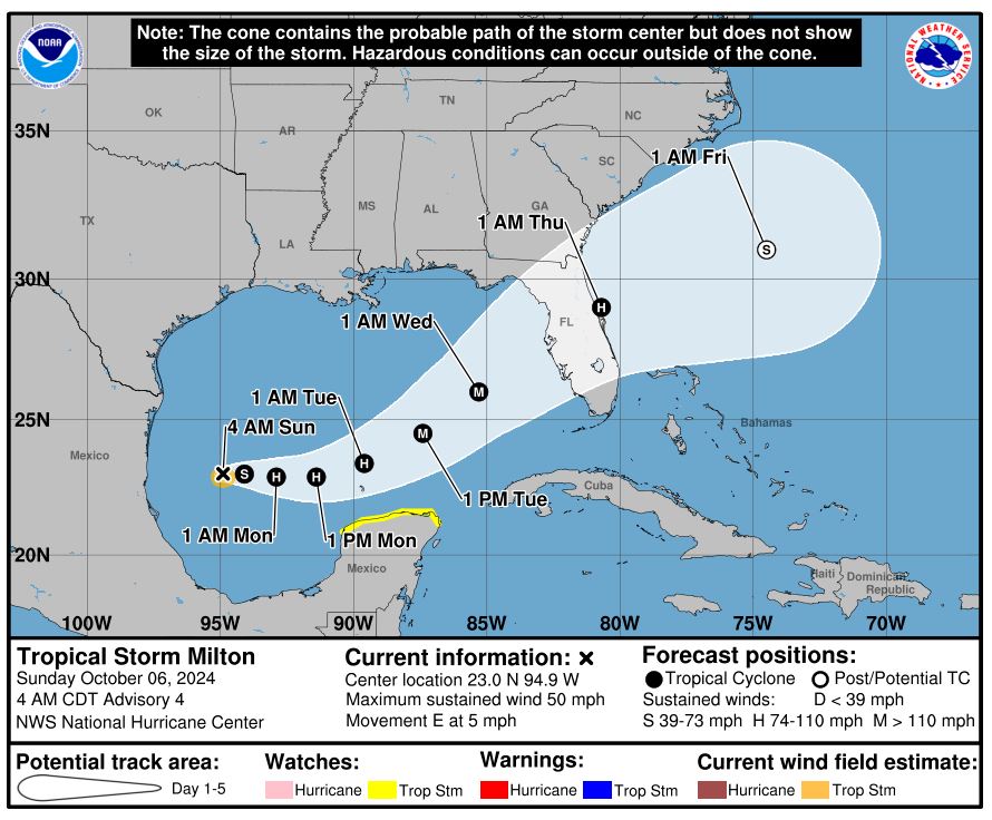
Helene *really* hit Anna Maria island hard: https://www.youtube.com/watch?v=xFHbfaV_wM4 Now that area is likely to get hit again from Milton unfortunately. (just started a thread on that one) My family rented a place down there in December. Looks like it's not going to happen.
-
Looks like the west coast of Florida is not going to get much reprieve. Milton expected to become a major hurricane, and possibly hit the Tampa area hard again. Update: now a hurricane.
-
Saw a couple of perhaps-useful sites - power outage info and road info for NC: https://poweroutage.us/ https://drivenc.gov/
-
With all the roads closed, but the Asheville airport open, it seems like a bit of a "Berlin airlift" kind of situation there right now. Is there food and supplies being flow in? If not, it seems like there should be. I have a relative stuck in Asheville right now. Not sure what his situation is, other than alive and with a place to sleep.
-
I-26 bridge at Erwin TN washed out. https://www.facebook.com/100064596347703/photos/936159315213938/?paipv=0&eav=AfakNstgGMfkESw_gDo-KpclLIIT-PwUJIRDV11V4L26hwG7lADMReKDUDmVJiitZMA&_rdr
-
Not quite taken from the same spot, but close. The bottom one is a little further down the road. https://www.wsoctv.com/news/photos-lake-lure/R22VATGCEJHL7KZEMOKB3KBUPU/ Looks like much of the town was wiped out. Not surprising since it is (or was) all right on the river.
-
For what it's worth - the river still hit record levels with severe flooding, at 28 feet high - and still rising right now! So I'm guessing most of the town is underwater right now anyhow. https://water.noaa.gov/gauges/NEPT1
-
That's probably due to the failure of the Waterville dam, which is just upstream of that.
-
Interesting - I know it's generally recommended to do September-ish, however if you have a lot of shade it does seem like August timeframe may be OK. Seems like a bit bigger risk with late-summer hot spell, though being more shaded helps with that. Unfortunately my lawn is half-shade half-sun. The half-sun part got decimated this year during the drought. Will probably give it a shot this weekend and hope we don't get any super hot spells over the coming weeks.
-
Argh - debating about aerating and overseeding the lawn early this year, this morning, since the upcoming weather pattern is fairly ideal. Wasn't ready yet but may rush it. Usually wait until September, but it'll be nice to have some rain this weekend, and not-so-hot weather in the forecast.
-
Forecast looking really nice next week for NoVA. Finally some good relief.
-
I was getting a bit worried about my well - wasn't sure how deep it is (it's not in county records), and also not sure how far down the water table is at my place. Found this good site which shows a method for measuring: https://sunshineworks.com/pages/measuring-your-static-water-level - both the water level and the depth of the well. Tried it and it worked great. Was quite relieved to find that the water level was at 68 feet, but the bottom of the well is at last 160 feet (ended up running out of fishing line before reaching the bottom).
-
Man I hope we get some more tonight and tomorrow night. Very disappointing with the clouds last night. fingers crossed.
-
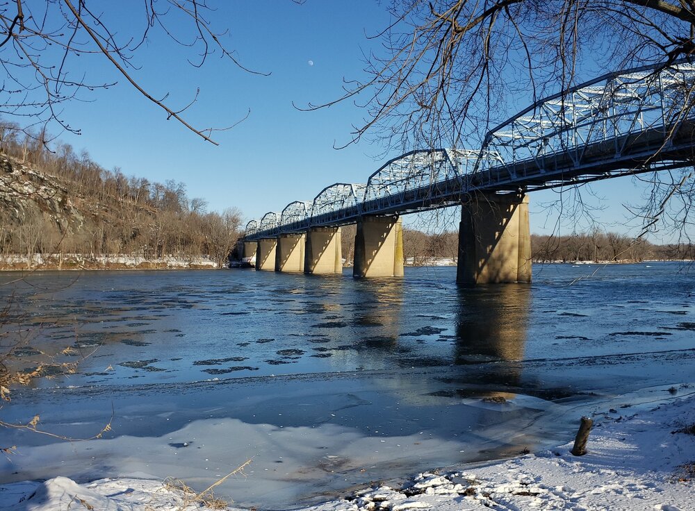
Thanks. Yeah - went up to Point of Rocks and there was a fair amount.
-
Anyone live along the Potomac, and can report if there's ice on / in it or not? Was thinking about going up that way for Sunday drive later. Always neat to see that.
-
You can also get a really good deal parking at the Marriott nearby - did that for recent vacation. Shuttle runs every 30 mins IIRC. Parking much cheaper than DCA long-term. Not sure what service (booked by wife) - maybe Park N' Fly.
-
A bust here on SW side of Leesburg, even at 800' elevation. A white tinge on the ground, but generally rain. Oh well. Just came from a funeral service in town - at 400' car said 42 degrees; then went down to 32 degrees at 800'.
-
I'm up on Hogback mountain (SW of Leesburg). On Monday we got snow all afternoon (though no accumulation), whereas just 200' lower in elevation it was all rain. Never seen it so clearly demarcated like that. Will be curious if the same thing happens this weekend.
-
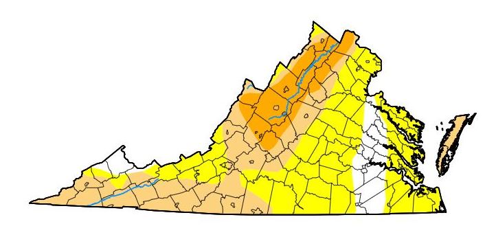
Virginia as of a few days ago: (will be getting worse)
-
That's a pretty cool data summary - where can I find that, if I may ask? I'm in LoCo, and indeed it's been super-dry, again, for the past month+. Thought we were going to get some relief about a month ago, but back to drought, with no significant rain in the 10-day. Not a good fall to try to plant some grass. Oh well.
-
Thanks!
-
Must be this one. https://fireball.amsmeteors.org/members/imo_view/event/2023/5012
-
Is there a good site to get water table readings? Thx.
-
OK - seems like then that the functionality I'm really looking for was in the WU-specific "radblast" tool? (that takes this data feed and makes the maps, adds the options, etc.) I've updated the OP to indicate.
-
Thanks for the tip. I find the radars on the NWS extremely klunky though. Really not much ability to customize view with pan and zoom. One of the things I liked about the old WU method was I could have a super-quick gif that was specific to my location - e.g. zoomed right in to the area just around my house, so I could tell practically down to the second when it was going to start raining from a storm. (RadarScope provides this, but only on phone, and it requires manual panning around - not a single quick click.) E.g. this was URL I used for the gif: https://radblast.wunderground.com/cgi-bin/radar/WUNIDS_map?station=LWX&brand=wui&num=12&delay=15&type=NCR&frame=0&scale=0.125&noclutter=0&lat=39.15021336&lon=-77.48304690&label=Leesburg%2C+VA&showstorms=0&map.x=400&map.y=240¢erx=428¢ery=280&transx=80&transy=80&showlabels=1&severe=0&rainsnow=0&lightning=0&smooth=0 (lat/long changed to protect the innocent) All I had to do was tweak that as desired, and bookmark it, and it provided a great way to quickly see local hi-res radar; no app required and no web page to load other than just the one super-quick gif frame. IIRC there was a newer version that was created a couple of years ago, that provided higher resolution, and I'm guessing that has something to do with this. I'm guessing it's a licensing thing - like the people that put out the output charge more $ for it now, and WU wasn't willing to pay. Just a guess though. (Yeah I know NEXRAD was not a Wunderground thing; just that that was the one site that seemed to pipe it through directly, with the NEXRAD name).


