WolfStock1
-
Posts
214 -
Joined
-
Last visited
Content Type
Profiles
Blogs
Forums
American Weather
Media Demo
Store
Gallery
Everything posted by WolfStock1
-
Well there's also the fact that it's lot harder to survive in extreme cold than it is in extreme heat, which is why so many more people die each year from cold weather. Human comfort / survivability is not one of the negative effects of MMGW. Sea level rise and increase in storms, yes. But not the temperature itself. IMO areas becoming "difficult to survive in" is a non-issue for MMGW. Any slight increase in storm activity is just noise in the overall background of improved infrastructure and weather prediction. A *lot* fewer people die these days from hurricanes and floods than they did in years past. (Sea level rise of course is a non-issue w/regards to survivability; the creep is way slower than natural human birth/death cycles. I always have to laugh when I hear of literal human "danger" proposed as being due to sea level rise.)
-
Are you sure? Why is it that the Wikipedia page on the subject: https://en.wikipedia.org/wiki/Outgoing_longwave_radiation doesn't discuss ENSO? The chart that's there doesn't seem to follow ENSO cycles: Keep in mind we're not talking about radiation *into* the atmosphere here (what I think is most affected by ENSO), we're talking about radiation from all earth elements (including the atmosphere) out into space (outgoing longwave radiation). Though I haven't attempted any kind of mathematical correlation - I thought ENSO cycles were generally much longer duration than what's in that chart.
-
So here's a question. Given that "the planet" is generally a self-contained system with very little (essentially no) variance in externalities with regards to energy inputs (mainly solar irradiance - generally near-constant) and output (terrestrial radiation - generally near-constant) - shouldn't the warming of the planet just be essentially a straight (or curved) line with an always-upwards slope, such that a new record should be set *every* year? Or is it the case that it's really just these records are just really just referring to "the places we are measuring" and not "the planet" as a whole? Yes - question is somewhat rhetorical, but is intended to trigger some thought. If one presumes that the planet as a whole is warming continually, then what are the "holes" in the data? Are there significant areas of the ocean for instance that we're just not measuring, and the reason we don't see a new record every year is because of the non-existent data that would offset the data we do have? Or perhaps is it the case that we are in fact measuring the whole "surface" (including the oceans), but the surface temperature as a whole actually does go up and down based on something - e.g. subterranean effects e.g. "bubbles" in mantle convection, or perhaps solar cycles?
-
Never seen in person but would very much *love* to see - sprites:

-
Occasional Thoughts on Climate Change
WolfStock1 replied to donsutherland1's topic in Climate Change
What's SUM? (assuming it's an acronym) Looks like it trended down until the 1950's, and has generally been flat since then, aside from the past couple of years. Doesn't seem like it would be an indicator of climate change; if that's what you're thinking. -
Wasn't there a big sleet-fest in '86 or '87? I was in Raleigh area, and I seem to recall us getting about 6" of sleet.
-
January 24-26: Miracle or Mirage JV/Banter Thread!
WolfStock1 replied to SnowenOutThere's topic in Mid Atlantic
See that a lot here. Not an expert but pretty sure it's a radar artifact. I believe the algorithm increases the sensitivity at further distances, at certain wavelengths. Light precip or things fog or drizzle mess with that algorithm, making it look like there's a hole in the middle when there really isn't. Something like that. That's my story and I'm sticking to it. -
January 24-26: Miracle or Mirage JV/Banter Thread!
WolfStock1 replied to SnowenOutThere's topic in Mid Atlantic
Anyone know why Apple weather is so different than NWS forecasts? I don't use it but my wife does, and here's what hers shows this morning for Leesburg area for Sunday: Umm.. what? 24" of snow? Only 70% max chance of precip? Totally different than legit forecasts. Only thing I can figure is that the app doesn't have the ability to account for wintry mix / sleet, so it just does some kind of "snow equivalent" or something (?). No clue why chance of precip is only 70%.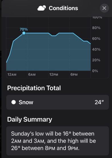
-
Occasional Thoughts on Climate Change
WolfStock1 replied to donsutherland1's topic in Climate Change
You sure you're reading those charts right? That's not what I'm seeing. E.g. in the 1950-1995 period it looks like the average number of record highs was about 2,000 or maybe 2,200, whereas the average number of record lows was around 2,500, before they diverged starting around 1995. Not sure how you're asserting a big ratio like that at any point the 20th century, aside from *only* a few peaks in the 1930's. The key thing seems to be the divergence after 1995, with record highs increasingly outpacing record lows. That trend doesn't go back as much as you describe though. -
Occasional Thoughts on Climate Change
WolfStock1 replied to donsutherland1's topic in Climate Change
Cripes man - not sure you really need to delve into the details of semantics with all your posts like that. From a scientific standpoint, there's no such thing as a "tie" when it comes to records. Temperatures are analog, with infinite granularity, and no two daily peaks are ever actually equal Perhaps there could be a tie from a measurement-device standpoint because no measurement device has infinite granularity - e.g. a given device may measure both 98.8 degrees and 99.2 degrees as "99" and consider it a tie. So thus how often one would expect a tie depends on the granularity of the measurement, and the units (F vs C). That's not mentioned in the OP. The main point I want to make though is - IT DOESN'T MATTER, because even in a "tie is considered another instance of a record" scenario - one would *still* expect a downward slope in the number of records over time. As you say - that's the nature of random number generation. Any new time an extreme peak is seen it means there's a lower possibility that peak (the record - be it a tie or not) will be achieved at any given point in the future, for any given sensor. As such - no I don't think the data presented could be considered "rigged". In part this is because the units and granularity of measurement aren't indicated, but also just the fact that the data trend is flat, and not downward-sloping (for daily record highs) indicates a general warming trend over the period. A rigged data set (e.g. if someone wanted to claim that warming wasn't going on) would show a downward-sloping trend. -
Occasional Thoughts on Climate Change
WolfStock1 replied to donsutherland1's topic in Climate Change
Well - that's kind of the definition of "record" is not? The 2nd through Nth time you see a given temperature, it's no longer a record. (Presumably the left end of the data is truncated; e.g. any given station would have 365 record highs and 365 record lows in its first year; assuming non-leap-year) -
Occasional Thoughts on Climate Change
WolfStock1 replied to donsutherland1's topic in Climate Change
Seems about right, and is consistent with a slow shift upwards in temperatures. In a no-change scenario one would expect both the number of record highs and the number of record lows to be decreasing over time. In a shifting-upwards scenario one would expect the number of record highs to be remaining about constant while the number of record lows decrease over time; those are apparent in those charts. -
Looks like the timing of the peak was such that Europe got the best of it last night. Some spectacular pictures. France:
-
Occasional Thoughts on Climate Change
WolfStock1 replied to donsutherland1's topic in Climate Change
In general the policy shift hasn't been "anti-renewable" though - it's been towards weaning renewables off the government tit to self-sustaining mode. The cancellations have been when people and companies find that many of these projects are not actually financially viable. However that said - of note is that this started happening in late 2023 - long before the current administration came in and started implementing its policy shift. As such much of the failures of these projects had nothing to with policy - but rather a slow popping of the post-covid renewable energy bubble. -
Occasional Thoughts on Climate Change
WolfStock1 replied to donsutherland1's topic in Climate Change
In general China is doubling-up their energy production - new fossil plants *and* new renewable (and nuclear) - because they can afford to. They can afford to because they pay their workers roughly 1/3 what US workers are paid, and because they generally don't worry about NIMBY or environmental impact like we do here in the US; e.g. their Medog Hydro project in Tibet. The US hasn't built a significant new dam in 50 years, let alone one close to the size of Medog or Three Gorges. (by comparison our largest - Grand Coulee - is about 1/8 the size of Medog and 1/3 the size of Three Gorges). It's not some kind of anti-renewable / pro=fossil policy that's holding back the US - it's a combination of higher regulation and environmental protection, NIMBYism, the fact that China is less prosperous than the US, and also simple geography. -
Occasional Thoughts on Climate Change
WolfStock1 replied to donsutherland1's topic in Climate Change
I like the idea, though when presenting I wouldn't be so specific. It wouldn't just be for millennials of course; it would be interesting for us Gen Xers as well (thus allow for longer-term data if you can). Also I wouldn't state "look to find a location hundreds of miles south" - that makes it look like you're purposely biasing the data; instead perhaps just "look to find a location that most closely matches the location of childhood" and the the user come to their own conclusions (typically they would find it some distance north/south; depending on whether looking back to childhood from a given location or looking forward to present from a given childhood location). -
Occasional Thoughts on Climate Change
WolfStock1 replied to donsutherland1's topic in Climate Change
From the way you describe it seems like your premise is that the climate (temperature in this case) is just a straight north-south gradient (?) and without seasonality. There are lots of places of course where the climate gets colder as you go south (e.g. into mountains); also it depends on the season - in many areas it gets hotter as you go north in the summer, but colder when you follow the same path in the winter. This is typical for instance as you move away from oceanside areas. E.g. Tampa's average peak high is 91 degrees, but if you go north to Tallahassee the average peak high is 93 degrees. But Tallahassee gets a lot colder than Tampa in the winter. So when shifting via warming the climate analog not only shifts around from season to season, but could even flip north/south depending on the location. That said - you could certain find some "pairs" of similar locations to do what you said. It just wouldn't work for a lot of locations. -
Occasional Thoughts on Climate Change
WolfStock1 replied to donsutherland1's topic in Climate Change
Thanks. -
Occasional Thoughts on Climate Change
WolfStock1 replied to donsutherland1's topic in Climate Change
Talk about political agenda - you love twisting everything that doesn't fit your narrative, don't you? There is no claim that there hasn't been an increase in the frequency of flooding in Miami. The "constant" just refers to the fact that Miami has experienced flooding all along - i.e. it's not something new to them; and therefore people who live there have to know how to deal with it. (As a tangible example of this - I recently rented a house on a Florida island that had recently experienced some hurricane flooding. The owner had recently done a couple of things - installed 2' stainless steel flood barriers in the doorways, and raised the output of the dryer from 6" off the ground to 4' off the ground. The barriers were already in place before the flooding; the dryer output thing got done after the flooding; apparently water got in there, though generally the house was fine.) It's noteworthy that you ignored the actual point and data presented, in your dismissal of my information based on my "political agenda". That's pretty typical of doomers I suppose - put your hands over your ears, shut your eyes, and ignore anything that doesn't fit your narrative, rather than presenting a counter-argument. -
Occasional Thoughts on Climate Change
WolfStock1 replied to donsutherland1's topic in Climate Change
Request - whenever providing data like this, please provide a link to the source. -
Occasional Thoughts on Climate Change
WolfStock1 replied to donsutherland1's topic in Climate Change
Funny the Florida example should come up. U-Haul just came out with their annual migration index the other day: https://www.uhaul.com/About/Migration/ Florida is the #2 growth state, with 8 of the top 10 and 12 of the top 25 growth metros. Lots of people committing suicide, I guess. (in case anyone's wondering - Texas is the #1 state and California is #50) -
Occasional Thoughts on Climate Change
WolfStock1 replied to donsutherland1's topic in Climate Change
Funny thing about Miami flooding - it's not a new thing: https://www.biscaynetimes.com/viewpoint/flooding-has-been-a-miami-constant-from-time-immemorial/ Here's another thing - Miami/Dade population: 2000: 2.259M 2010: 2.507M 2020: 2.696M 2024: 2.838M Funny how people seem to want to move *to* this area that supposedly has all these flood problems. They apparently haven't gotten the news about the sky falling. (BTW - I used to live in the area, and visit Florida regularly - I know what it's like. The sky is not falling.) I wouldn't propose that flooding won't be more frequent there - it will. I'm just saying it's not some kind of life-threatening - or even lifestyle-threatening - thing. It just means that over time (we're talking centuries here, not years or even decades) new things need to be built on slightly higher ground and/or with more sea walls in low-lying historic areas. It's not that hard. Dealing with it will certainly be a lot less disruptive than the sudden worldwide loss of fossil fuels required to prevent it.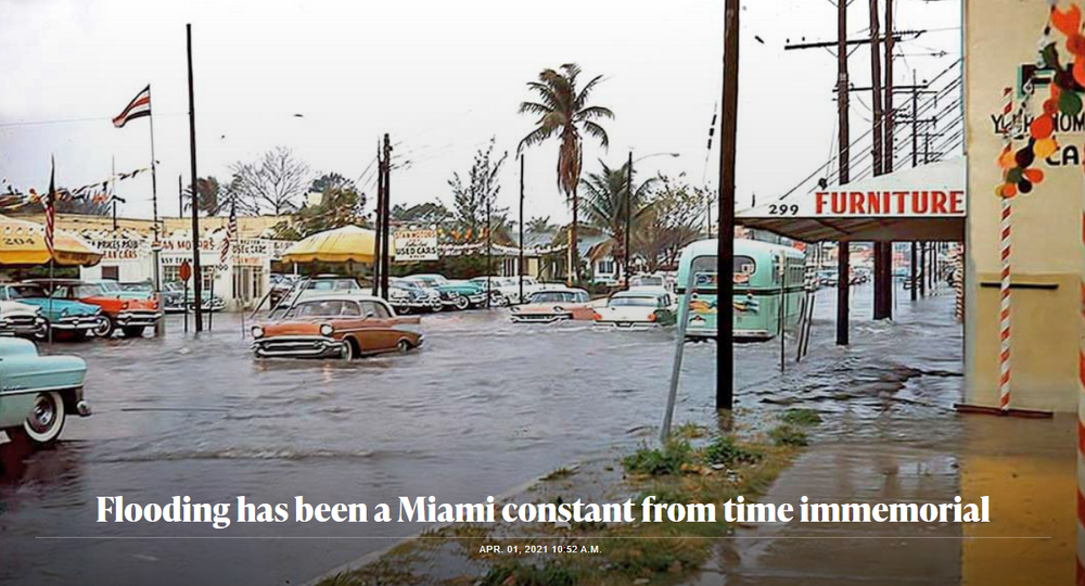
-
Occasional Thoughts on Climate Change
WolfStock1 replied to donsutherland1's topic in Climate Change
This. I don't think the "sky is falling" people realize just how foolish they look when anyone who doesn't toe the sky-is-falling line must be a denier; and as a result how counter-productive it is to their cause. -
Occasional Thoughts on Climate Change
WolfStock1 replied to donsutherland1's topic in Climate Change
Not yet. Sorry - could not let that slide. "Performance" is a multifaceted thing, including speed, driving distance, fueling convenience, costs, build quality, etc. etc. If the performance of the average EV and the average combustion vehicle in the US (what most of us care about) matched, their sales would be roughly equal, but they very much aren't; even before the recent subsidy removal. -
Question for those in the know: Since urban heat island is a thing - has there been a concerted effort to place sensors specifically in non-urban areas? If not - it seems like there should be. Of course some areas could transition from non-urban to urban over the course of decades, but such an effort/project would presumably account for this - putting sensors in areas that are protected and would never becomes urban (national parks, wildlife refuges, etc.) and/or just remove any sensors that have become urbanized from the data sets. As it is - it seems like threads like this one - "XXX city sees record warmth", are of questionable veracity; to me what would be more meaningful would be "Badlands NP sees record warmth" or the like. (at first I started using Yellowstone as example but then realized it has its own non-urban heat island)