WolfStock1
-
Posts
214 -
Joined
-
Last visited
Content Type
Profiles
Blogs
Forums
American Weather
Media Demo
Store
Gallery
Everything posted by WolfStock1
-
Thanks.
-
A general request for everyone. Whenever you post a chart - can you post a link to the source? (I get into discussions with others and often want to point them to the data; or in some case I want to look at subsets / variations of the data - e.g. this case it's not clear which year is the record year that we're contending with.) Thanks.
-
So a big *wow* at that super-strike the other night. Talking with a Leesburg FD person in church this morning - they got a bunch of calls from people reporting "a big explosion". And this is 15 miles from where the strike happened. I can't image how loud it must have been in Brunswick. Anyone happen to have any direct reports or pictures of where it struck?
-
Occasional Thoughts on Climate Change
WolfStock1 replied to donsutherland1's topic in Climate Change
50 states x 12 months = 600 records for "highest temperature for state X during month Y". To be honest - breaking one of those every now and then seems like not so much of a big deal, and would be expected regardless of whether the planet is warming or not. Point being - perhaps showing trendlines of more broad data would be a lot more meaningful and poignant that touting a given broken single-state record for a given month. As it is these posts with their desert graphics, and the obvious troll phrasing, seem very... tabloidish (or perhaps clickbait-ish being the modern equivalent), especially on a forum that thrives on deep data analysis. -
Occasional Thoughts on Climate Change
WolfStock1 replied to donsutherland1's topic in Climate Change
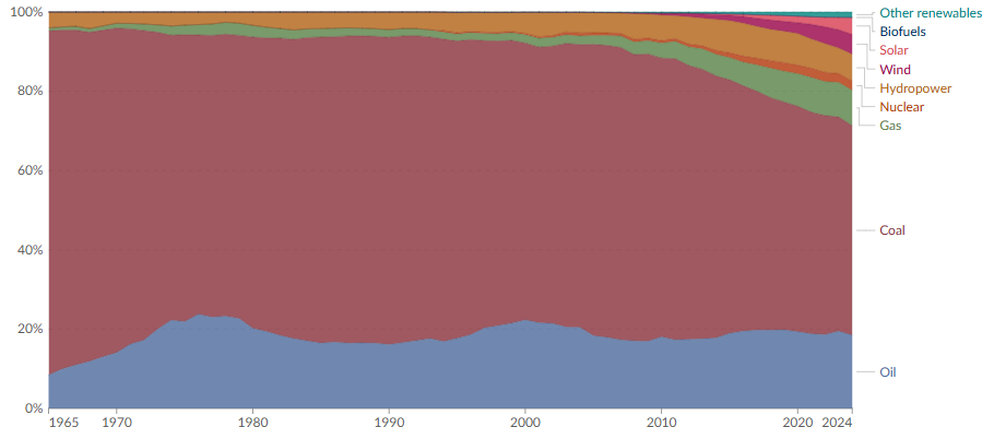
That's fine, except the rest of the world is generally in a different situation than the US. And the switch to renewables has been painful in many places. Germany has been the poster child, but their electricity prices have been skyrocketing, and their economy is struggling as a result. But even with that - most of their energy use is still fossil - well over 70%: So again - what is the scale of those charts you posted? It's not there, for a reason. All they show is "up", but they don't show how *much* up, relative to actual fossil usage. China has indeed been going full-bore to renewables, but they're still mostly fossil: They're at about 10% wind and solar. Again - low-hanging fruit; not baseline power. And they generally have zero respect for the environment; doing big projects that just aren't feasible in the US. With regards to EV sales - apples to oranges situation-wise. They're still heavily subsidized in most places. If they're a slam-dunk - then why are they so heavily subsidized? China's EV sales have been doing great - and that's great - but Chinese workers are paid about 1/3 the salary of the US; they can afford to do everything cheaper. Low hanging fruit, as they try to catch up with the developed work economy-wise. If they had our level of prosperity they would not be able to do this. China is also building tons of new coal power plants BTW, along with their renewables growth.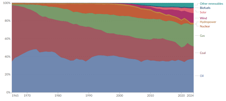
-
Occasional Thoughts on Climate Change
WolfStock1 replied to donsutherland1's topic in Climate Change
Look - I'm not trying to argue that renewable energy isn't a good thing, and that it's use is not growing. I'm just saying that the over/under on benefits vs costs are generally way overblown and propagandized; that the reality is that it's harder than people such as yourself think it is, in particular when it's applied on a universal scale of all energy. -
Occasional Thoughts on Climate Change
WolfStock1 replied to donsutherland1's topic in Climate Change
Except that data is old. And there's no scale. And it's obviously cumulative, not showing actual new deployments over time. In short - it's fluff propaganda, not reflecting reality. E.g. EV sales are now on the decline - e.g. see CA and NY who have detailed trackers on sales, due to their mandate (which will clearly not be met at this point) As I've maintained - much of renewable energy has been "low hanging fruit" so far, in particular in the U.S. Specifically - nearly all of our wind-based electricity and our solar-based electricity in the US is generated in places that have... lots of wind and lots of sun. But - not coincidentally - that tends to be places where there aren't as many people living. The fraction of renewable generation and use that happens in states that don't get as much sun is much smaller. The problem is that the highest population concentrations in the US live in those areas - in particular the NE population corridor.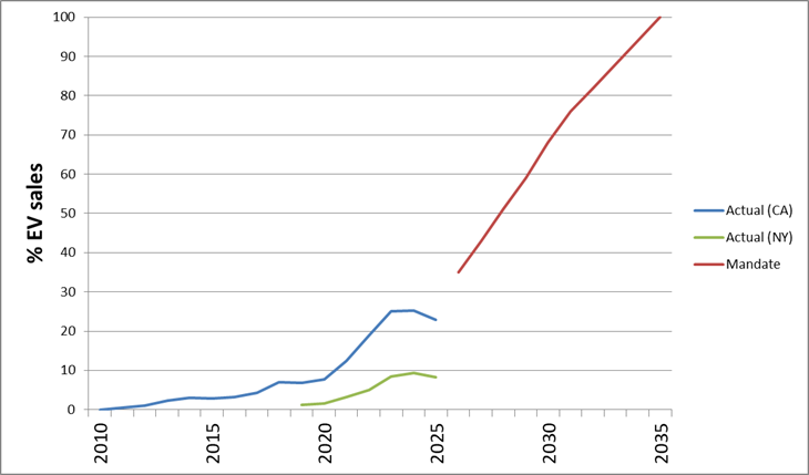
-
Occasional Thoughts on Climate Change
WolfStock1 replied to donsutherland1's topic in Climate Change
Making a blanket statement like that shows how how much you've been influenced by the propaganda machine, and generally ill-informed. In general no - renewables are not cheaper in most circumstances, when all factors are considered (inclusion of additional baseline power sources for when the wind and sun don't cooperate, additional transmission infrastructure, higher land use, etc.). They can be cheaper only in specific circumstances when the stars align; they are not cheaper in a broad-use infrastructure sense. If they were cheaper, then power companies wouldn't need the much-higher-level of subsidies to incentivize their use. -
Occasional Thoughts on Climate Change
WolfStock1 replied to donsutherland1's topic in Climate Change
Presuming that you're talking about nuclear - the problem is that there has always been *too much* talk about the tail risk; i.e. blowing out of proportion. -
Occasional Thoughts on Climate Change
WolfStock1 replied to donsutherland1's topic in Climate Change
Interesting. Got a link for that? I didn't realize wind and solar prices had been going up like that. You hear about prices going down, though generally it doesn't include the transmission aspect; which is generally much higher because wind and solar are prevalent in areas where people that use the energy *aren't* as prevalent. As such I've maintained that we're about done picking the solar and wind "low hanging fruit"; this chart appears to show evidence of that. -
Occasional Thoughts on Climate Change
WolfStock1 replied to donsutherland1's topic in Climate Change
The physics I was referring to is simply energy density. Fossil simply has much, much higher energy density than solar, wind, or hydro. (though a lot less than uranium) As an example of that - the county that I live in has two interestingly-comparable new power plants: 1. A natural gas plant that produces 780 MW of power, on 100 acres of land 2. A solar farm (being built) that will produce 100 MW of power (when the sun peaks), on 800 acres of land When accounting for base load levels - the solar farm will produce roughly 1/250th the amount as the natural gas plant, on a per-acre basis. That's what I mean. (Obviously there's more to it than just acreage-used; that's one example facet) With regards to India - I don't see any "fast track" in that chart you posted. It looks like they're behind to me. They are, however, rapidly catching up in regards to how much CO2 they are emitting, at least compared with the US: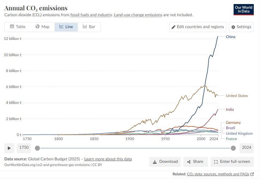
-
Occasional Thoughts on Climate Change
WolfStock1 replied to donsutherland1's topic in Climate Change
It was *never* going to be anywhere close to "cheap" to hedge, at any point. You're fighting not only physics, but politics and human nature. It would require not only taking a huge hit to our prosperity - but convincing all the other countries in the world to take that same hit. Good luck with that. I don't think you understand just *how* much of our prosperity is based on the foundation of fossil fuel use. It's literally been the basis for the industrial revolution. The big inflection point was 150 years ago - not 20 years ago. But if we somehow had managed to avoid that inflection point - we wouldn't have anything close to the prosperity we do today. We perhaps had a smidgen of a chance decades ago, with the advent of nuclear power. But then the clueless anti-nuke lobby, led by the likes of Ralph Nader, ensured that wasn't going to happen*. Even still that would have only gotten us so far; even with all-nuclear electricity we still would have other fossil fuel uses in transportation and industry to deal with. (*Edit: In his defense - he didn't know about MMGW back then. He might have a difference stance today if so. Nevertheless - he and others like him were responsible for the extreme over-reactive risk aversion that killed nuclear.) -
SW of Leesburg: Big drop yesterday was storm line. Now down to 32.7 and snowing hard.
-
Occasional Thoughts on Climate Change
WolfStock1 replied to donsutherland1's topic in Climate Change
Sorry but the FUD approach is just getting tiresome. I think you vastly underestimate both the adaptability of humans and the durability of planet Earth. People hear what Chicken Littles have been saying for decades - and then they look at the *actual* impacts that are happening - and the two just don't match. E.g. Weather-related deaths continue to decline, mass die-offs of species like polar bears isn't happening, coastal areas aren't becoming inhabitable due to being underwater, the polar regions still have year-round ice, etc. As a result the general population seems to be souring on the climate change hysteria, realizing that we aren't in fact in an existential crisis, with many even questioning the veracity of the predictions wholesale. Maybe it would behoove to be more pragmatic in the approach - something other than "the world should be very afraid" stance. -
Occasional Thoughts on Climate Change
WolfStock1 replied to donsutherland1's topic in Climate Change
IMO trying to use/apply a single decade's worth of data is a fool's errand. There's too much background noise there in the ENSO and solar cycles. IMO anything meaningful with regards to changes in the rate of increase would need to be over at least a 20-year period, or even 30. That said "meaningful" here I equate with "strong evidence". 10-year data isn't totally meaningless - it's worth at least eyebrow-furrowing when it indicates something unusual. I just wouldn't use it to make a statement to the effect of "this shows that the rate of warming is increasing". -
Occasional Thoughts on Climate Change
WolfStock1 replied to donsutherland1's topic in Climate Change
I believe UHI effect, while a thing, is overblown as well. My point though is - deniers like to point to UHI as tainting the data and general claims of trends, so in order to remove all doubt it would be good to have a data set (more than a single station, but rather hundreds of stations) that are truly remote. It appears the USCRN is a mix of some remote and some not-so-remote sites. Doing a filter of the USCRN data and weeding out the not-so-remote sites and presenting an average would seem like the thing to do. The Lake Erie thing actually brings something else to mind. Has anyone done studies on how much water warming (mainly rivers and lakes) is due to general industrialization vs greenhouse effect? It seems like it could be quite significant actually. I mention this because I was looking into water usage recently (context was discussion on data centers) and found that actually one of the biggest water consumers in the US is power plants - used for cooling. There's more water used for cooling power plants than there is for irrigation, believe it or not. Much of this is evaporative but much ends up back in rivers and lakes, raising their temperature. Much is used for other industrial things as well, which certainly raises the temperature some. -
Occasional Thoughts on Climate Change
WolfStock1 replied to donsutherland1's topic in Climate Change
Yes unlike many of the others Georgia appears to have done a good job picking truly remote sites. Ideally you'd like to see all the sites be like that, since it's usually an average of all sites that's shown (e.g. in the X post). I haven't looked for it, but was just noticing that a lot of the references in this thread to records / high trends are in areas that may be subject to UHI effect. Would be nice to see some for remote sites instead, since IMO that's much more meaningful. -
Occasional Thoughts on Climate Change
WolfStock1 replied to donsutherland1's topic in Climate Change
Here are the Georgia sites:

-
Occasional Thoughts on Climate Change
WolfStock1 replied to donsutherland1's topic in Climate Change
Hmmm - well - looking at their locations https://www.ncei.noaa.gov/access/crn/ - that's not really what I'm talking about. It looks like just about all of those sites are actually suburban sites, or at least "close to city" rural sites. For example the one in central NC is in Duke Forest - but that's practically surrounded by Durham, which is a fast-growing urban area. The one in southern LA is at Cade Farm which is rural-ish, but is only 3 miles from the edge of Lafayette. The one in western VA is only 1 mile from I-64 and Charlottesville, Etc. What I'm talking about would be truly rural sites - ones where there isn't a significant city within about 50-100 miles or so. I see very few if any sites of those that fit that bill. -
Occasional Thoughts on Climate Change
WolfStock1 replied to donsutherland1's topic in Climate Change
Not an expert in UHI effects, but Lander isn't exactly the middle of nowhere - it is a town of 7k+ people. What's needed is data like this from actual remote sites, that aren't at cities / towns at all - e.g. sensors at national parks / forests, etc. Remove all question w/regards to UHI. -
About damn time.
-
Feb 22nd/23rd "There's no way..." Obs Thread
WolfStock1 replied to Maestrobjwa's topic in Mid Atlantic
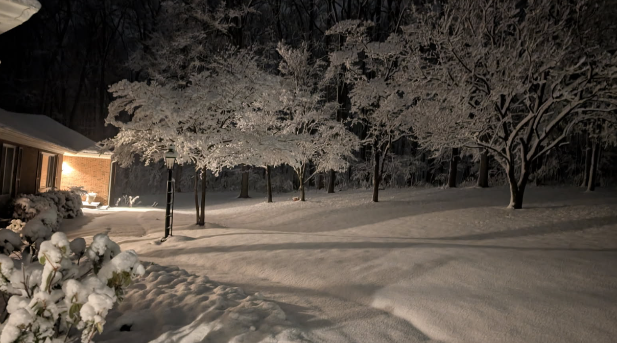
SW of Leesburg VA we got right at 5", so it appears more than most in the area. Was a really sticky and beautiful snow Sunday night. (we got a bit more after the pic was taken)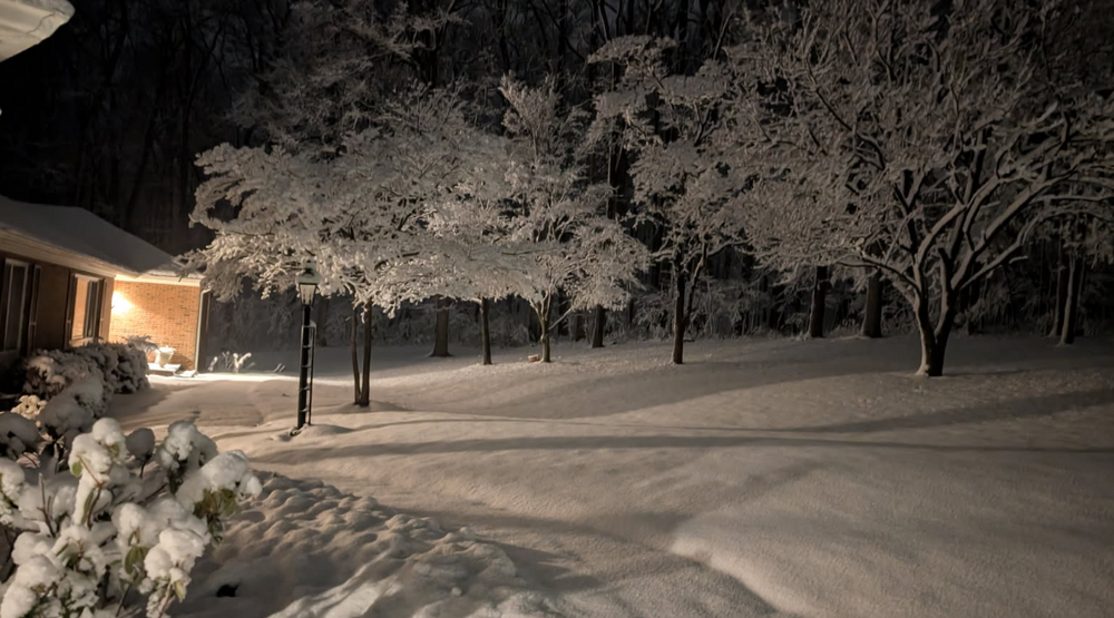
-
Bunk. The world has solved lots of problems, without having solved all of them. The notion that if you can't solve one problem then you can't solve any problem is ludicrous.
-
Your level of understanding of worldwide systems, and your worldview, is made pretty clear from that last sentence. The rest just naturally follows, and isn't even worth addressing. We'll just leave it at that.
-
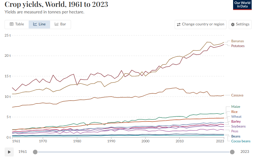
Boy you hit about all the MMGW scapegoat talking points there, didn't you? You forgot about rape though. (Yes, it's a thing) I'll just hit one of the scaries for now - crop failures - the rest can be inferred. The sky-is-falling narrative tends to fall apart when you look at the actual data, and not individual anecdotes. (ironically - much like looking at a weather event and claiming that it's an indicator of climate trends)