

TimB
-
Posts
17,206 -
Joined
Content Type
Profiles
Blogs
Forums
American Weather
Media Demo
Store
Gallery
Everything posted by TimB
-

Pittsburgh/Western PA Summer 2022 Discussion
TimB replied to Ahoff's topic in Upstate New York/Pennsylvania
Especially weird that it would be two years in a row with 90s in June and none in July. Still, I think we get there a couple times. -
Pittsburgh/Western PA Summer 2022 Discussion
TimB replied to Ahoff's topic in Upstate New York/Pennsylvania
I assume we’ll hit 90 at some point this month but it’d be funny if we didn’t. -
Pittsburgh/Western PA Summer 2022 Discussion
TimB replied to Ahoff's topic in Upstate New York/Pennsylvania
As I see it, there are two possibilities for next week: either warm, humid, rainy and gross, or deathly hot but dry. -
Pittsburgh/Western PA Summer 2022 Discussion
TimB replied to Ahoff's topic in Upstate New York/Pennsylvania
We’re getting pretty close to that “we really need rain” stage. Wouldn’t say it’s dire yet, but we could well be dry through the weekend if we miss out today. But I’ve really enjoyed not mowing, so maybe I shouldn’t be worried. -
Indeed. Sad days in the Burgh, but the product on the field won’t be any better.
-
If I run the report on xmACIS, it’s one of the weakest records in July, though it shows as 88 in 2011 on there so I’m not sure where the 86 came from. Interesting that DUJ hit 87 today, PIT didn’t even hit 87.
-
Pittsburgh/Western PA Summer 2022 Discussion
TimB replied to Ahoff's topic in Upstate New York/Pennsylvania
Euro backed it off. We’ll see if it comes back. -
Pittsburgh/Western PA Summer 2022 Discussion
TimB replied to Ahoff's topic in Upstate New York/Pennsylvania
Trend seems to be toward mostly garden variety heat, but I wouldn’t rule out a day or two of big heat (95+) mid to late next week if everything lines up right. -
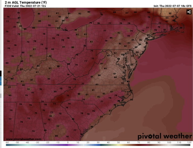
The 6z largely keeps the extreme, ridiculous heat out of the east. Verbatim, it would obliterate all-time records in a lot of cities in the middle of the country, by 5+ degrees in some places.
-
The panel from that run that really made an impression on me was the temps at 8am the morning of the second hot day. Yikes.
-
Pittsburgh/Western PA Summer 2022 Discussion
TimB replied to Ahoff's topic in Upstate New York/Pennsylvania
Looks like we’re going to finish June basically average for temps. We’re at +0.2 and today should be roughly normal with a low about a half dozen degrees BN and a high about a half dozen degrees AN, so should stay +0.2. -
Pittsburgh/Western PA Summer 2022 Discussion
TimB replied to Ahoff's topic in Upstate New York/Pennsylvania
Was looking at records to see if we had a shot at a record low tomorrow morning. We don’t, but interesting to note that that the record low of 47 was set in 1988, along with a low of 46 just two days later. We know what came both before and after those chilly mornings. -
Pittsburgh/Western PA Summer 2022 Discussion
TimB replied to Ahoff's topic in Upstate New York/Pennsylvania
Official high of 94 today. Let’s hope that stays the hottest day of the summer. -
Pittsburgh/Western PA Summer 2022 Discussion
TimB replied to Ahoff's topic in Upstate New York/Pennsylvania
And indeed, the 1:30 obs was 91. 3rd 90 of the season. -
Pittsburgh/Western PA Summer 2022 Discussion
TimB replied to Ahoff's topic in Upstate New York/Pennsylvania
Low at PIT was 46. Record tied. -
Pittsburgh/Western PA Summer 2022 Discussion
TimB replied to Ahoff's topic in Upstate New York/Pennsylvania
Truly a gorgeous night out there, and a spectacular 3-4 day period ahead. -
Pittsburgh/Western PA Summer 2022 Discussion
TimB replied to Ahoff's topic in Upstate New York/Pennsylvania
Indeed 74 was reached at 7:45. A few spectacular days ahead and the next climo thing to watch is Sunday morning’s record low of 46, and I think we could get close. -
Pittsburgh/Western PA Summer 2022 Discussion
TimB replied to Ahoff's topic in Upstate New York/Pennsylvania
Going to be close but already 76 at PIT. Interesting that this thing was completely dry. -
Pittsburgh/Western PA Summer 2022 Discussion
TimB replied to Ahoff's topic in Upstate New York/Pennsylvania
The very large hail threat is honestly the most concerning to me, as the SPC seems to want to center that on our area. -
Pittsburgh/Western PA Summer 2022 Discussion
TimB replied to Ahoff's topic in Upstate New York/Pennsylvania
I think there’s quite a bit of question if our low of 74 holds through midnight, but if it does, it’d be only the second time since records started being kept at the airport that a low of 74 has been recorded this early in the season (6/8/08 had a low of 75). -
Pittsburgh/Western PA Summer 2022 Discussion
TimB replied to Ahoff's topic in Upstate New York/Pennsylvania
This went ENH for our area with the latest SPC D2 outlook. -
Pittsburgh/Western PA Summer 2022 Discussion
TimB replied to Ahoff's topic in Upstate New York/Pennsylvania
Yikes, that dewpoint at CMH is 82. -
Pittsburgh/Western PA Summer 2022 Discussion
TimB replied to Ahoff's topic in Upstate New York/Pennsylvania
12z HRRR has us getting to 97 tomorrow but first of all, it’s the long range HRRR and second of all, everything else seems to have at least some rain/storms and 90 is indeed a struggle on some models. -
Don’t get me wrong, the GFS and CMC also mix dewpoints into the comfortable range down there, but upper 50s, not near 40, and I think that’s probably more reasonable. Makes sense to me that temps would torch if humidity cratered like that under a massive ridge. I just don’t see it happening. Regardless, signs are definitely pointing to the ridge reloading next week, perhaps with a vengeance.
-
I have a hard time believing dew points will be in the low 40s in South Carolina in late June, especially while it’s muggy up here, which is what I would think allows those readings to be achieved.

