

TimB
-
Posts
15,341 -
Joined
Content Type
Profiles
Blogs
Forums
American Weather
Media Demo
Store
Gallery
Posts posted by TimB
-
-
2.1” officially at PIT as of 1pm. Need a miracle to break our streak of no advisory level events.
-
1 minute ago, MikeB_01 said:
lol its alright. We all go off the edge sometimes... Enjoy the snow. Remember the absence of winter last year and try to appreciate a day like today
Indeed, one week of winter (and maybe more if we’re lucky) is better than zero.
-
 1
1
-
-
Just now, Burghblizz said:
Seeing more reports of 3” and 4” and less reports from TimB
The mark of a decent event.
-
1
-
-
Think I spoke too soon about this being a complete disaster. It’s probably going to be a slight letdown when all is said and done, but we’ve had much worse.
-
4 minutes ago, RitualOfTheTrout said:
Shortwave trough extending from the Upper Great Lakes to the
Tennessee Valley region. Snowfall rates have been light, with
the 12Z PIT sounding showing poor lapse rates in the dendritic
region. Lowered additional snowfall amounts to account for the
lower snow/liquid equivalent ratios and less favorable ascent.
Better jet support and divergence was south of the region across
the Appalachians.

The latest RAP output shows favorable omega to maintain the snow
through the afternoon
I was a bit worried when models adjusted south yesterday with the vort pass and seemed to lose some of the moisture if we might also lose some of the dynamics needed to maximize the liquid to snow ratio. Its such a difficult thing to pin down though I didn't want to be a deb for no reason.
And yet your instincts turned out to be correct, because every storm finds a way to bust around here.
-
-
I’d like to know the secret to viewing a 2” event positively when every single model had us getting at least 3 and the NWS pretty much guaranteed it (90% chance).
-
In the 143 seasons of records prior to last year, there were 7 that failed to produce an advisory level snowfall (5%). Now we’re on the cusp of two in a row.
-
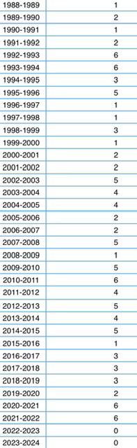
Number of 3” snowfalls, last 36 winters:
-
And it’s not even the NWS’s fault. Every single run of every single model yesterday had us getting a solid 3-5” event and we still got fucked.
-
It’s just ridiculous. This one, the NWS had a 90% chance of 3” or more and it’s still going to fail.
-
7 minutes ago, PghPirates27 said:
My weather channel says 1” for today now
Add that to the 1” that was officially observed at the NWS at 7am and that’s 2”, which means an advisory bust.
-
11 minutes ago, KPITSnow said:
Glad we built up this period for two weeks to get a three inch storm Tuesday and probably two inches today.
this one today is failing miserably
3” used to be incredibly easy to get. Like it used to happen several times a season. But now it hasn’t happened for two years, at least officially at PIT.
-
Just woke up. Are we going to fall short of an advisory level event AGAIN?
-
Dewpoints are currently in the single digits. Does that mean we battle dry air at onset again?
-
3 minutes ago, Rd9108 said:
I just think it's an easier forecast. It's mostly northern stream, no big phase, no crazy high movement, no temp issues, etc...
Yeah. Definitely to be enjoyed. We don’t get these too often, let alone twice in the same week.
-
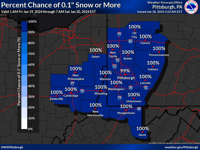 Of course, my favorite graphic is this one.
-
NWS seems to agree with the sentiment that this won’t bust badly, with probabilities of 2” at 85%+ across the county.
-
25 minutes ago, KPITSnow said:
I don’t know if this warrants an advisory even. I mean 2-4 inches but over more than a 24 hour period lol.
No it doesn’t warrant an advisory. It’s a long duration event that might meet advisory criteria over 36-48 hours. That said, 3-4 inches of snow on snow would be satisfactory. But if it’s 1-2 inches, why even bother?
-
It’s been the same old story over and over again for every single snow event that’s happened the past two winters. Today’s NWS discussion:
- Snow chances increase on Thursday, but the main focus for
  widespread accumulations will be Thursday night and Friday.
  Snow accumulation could exceed criteria for headlines, but
  current probabilities are pointing to the highest threat in
  the ridges.
-
Running out of time for an actual good event. If we come back from next week’s thaw quickly, there’s 5, maybe 6 weeks left.
It’s sad that our bar for satisfactory at this point is set at advisory level snowfalls or even less, but we really could go another winter without one.
-
1
-
-
7 minutes ago, TheClimateChanger said:
The earlier map also started at 1 am Thursday, not 1 am Friday. I think they were expecting a bit more snow on Thursday. Now it looks like a half inch at best.
Oh right, so it was never an advisory event in the NWS’ eyes. It was two separate events totaling 3.some inches.
-
NWS has dialed us back to some stupid little sub-advisory level 2.4” event, which is actually the same as what we got yesterday. Their discussion repeats the same old stupid little mantra of “advisories are likely in the ridges” that has pretty much defined the last two years. Not ideal, but would get us into the double digits for the season.
-
Low end amount of 2” in Pittsburgh is pretty solid.

Pittsburgh, Pa Winter 2023-24 Thread.
in Upstate New York/Pennsylvania
Posted
Well there’s that too. But our streak of no calendar days with 3” of snow would seem to be intact unless a band sets up over the airport. Well, the NWS office, but close enough.