TimB
-
Posts
17,226 -
Joined
Content Type
Profiles
Blogs
Forums
American Weather
Media Demo
Store
Gallery
Everything posted by TimB
-

Central PA Summer 2026 Discussion/Obs Thread
TimB replied to Voyager's topic in Upstate New York/Pennsylvania
Stebo is a degreed meteorologist, I’ll trust his thoughts on the matter over some guy with a weather station and an agenda. Can I see a pic of your setup? -
Pittsburgh PA Summer 2026 Thread
TimB replied to TheClimateChanger's topic in Upstate New York/Pennsylvania
Another thing to watch: the warmest low ever recorded at the airport is 77, on 7/23/2010 and 7/16/1980. Seems attainable, possibly Friday morning. -
Pittsburgh PA Summer 2026 Thread
TimB replied to TheClimateChanger's topic in Upstate New York/Pennsylvania
As it stands now, the NWS point and click has temps not dropping below 75 at KPIT Wednesday/Thursday/Friday. That last happened on three consecutive days in 1917, and never at the airport observing site. I don’t think the highs reach the more absurd levels that some models and forecasts show, and history just doesn’t favor days and days of mid to upper 90s, but consecutive days of very warm lows seems very plausible. Something to watch. -
I’m guessing it ends up somewhere around -1, so right around the 1981-2010 normal.
-
Point and click for PIT is 90 on Monday. This would be the earliest 90 degree day in the season since 1993. Also, the record high for May at the airport site is 91 (all of the days that got above 91 were observed elsewhere). So if PIT can break or tie that record, it would be the second month this spring with a monthly record high at the airport site.
-
Officially a trace of snow at PIT today.
-
As I recall, we did the same in the first half of May 2017. I remember a day or two that struggled to get out of the 40s, which is what this looks like. Not 2020 levels by any stretch, but still pretty cold. Regardless of intensity, it does seem to have a little staying power, especially on the Euro ensemble. The trough reloads and swings back through later next week and it stays troughy in the east through the end of the run.
-
Warmest April is in the bag. We’re running a degree and a half ahead of 2017 with just two days left in the month, which, although chilly, will still allow us to finish close to a full degree ahead.
-
Update to the warm lows: we are now at 8 days with lows in the 60s. No other year in the entire period of record, KPIT or not, has had more than 5 through today’s date. Lastly, today is the 15th day of this year with a high of 75 or above, which is the most through today’s date, pulling ahead of 1945 which had 14. No other year had more than 9. The median number of 75 degree days through today’s date is 2.
-
Also with the window for measurable snow this month likely closed, the 0.2” we’ve received combined over the past 4 Aprils is the second lowest total April snowfall over a 4 year span (1945-1948 had just a trace in each year).
-
Potential seems to be increasing for a 6 day stretch next week where PIT doesn’t drop below 60. That has never occurred in April.
-
Daily record warm low secured (62). This is tied with 3/27/1998 as the only days this early in the season to have a low of 62 or higher in the Pittsburgh International era. This is also already the third day this year with a low in the 60s, moving ahead of last year for the most so early in the season at Pittsburgh International (1952-present). These are the only years to have more than one. Number of days on or before April 3rd to have a low in the 60s at Pittsburgh International: 1952-2024: 4 2025-2026: 5 This is getting to be like the steroid era in baseball.
-
5th warmest March on record in the Pittsburgh International era (1952-present), just behind 2025 and just ahead of 2024. So 3 of the top 6 in those 74 years have been consecutive.
-
Update: @RevWarReenactoris out of the hospital but faces a long road ahead. He’s in the care of some good doctors but faces surgery in a few weeks and could be looking at dialysis in the near future. But to be clear, it’s the result of a birth defect, not lifestyle choices. It wasn’t the Big Arch!
- 252 replies
-
- 11
-

-
Pittsburgh/Western PA WINTER ‘25/‘26
TimB replied to Burghblizz's topic in Upstate New York/Pennsylvania
The current temperature of 83 at PIT is tied for second warmest March day on record, and is the earliest in the season that we’ve ever reached 83. Edit: we’ve now at least tied the monthly record of 84, set on 3/25/1929. -
It’s my understanding that he’s out of the hospital now but facing surgery and uncertain recovery. His house also got damaged by the severe storms the other day, so insult to injury.
-
Pray for @RevWarReenactor. I have been tasked with the unpleasant duty of informing you all that he is currently in the hospital with a severe kidney stone episode that has possibly led to kidney failure after eating a Big Arch and it’s questionable if he’s going to make it. I know some in this sub don’t see eye to eye with him but he’s still human and some things transcend message board drama.
-
Pittsburgh/Western PA WINTER ‘25/‘26
TimB replied to Burghblizz's topic in Upstate New York/Pennsylvania
Yesterday was only the 2nd calendar day on or after March 16th to get 6+” of snow in the past 70 years. The other was of course that day in 2018. -
Pittsburgh/Western PA WINTER ‘25/‘26
TimB replied to Burghblizz's topic in Upstate New York/Pennsylvania
Official NWS obs was 6.3”. We officially got to warning level out of this thing. -
Pittsburgh/Western PA WINTER ‘25/‘26
TimB replied to Burghblizz's topic in Upstate New York/Pennsylvania
Lucking into a semi-respectable March snow total from one overperforming event in what has otherwise been a torchy, April-like month is really something. That puts the official seasonal total over 50”. -
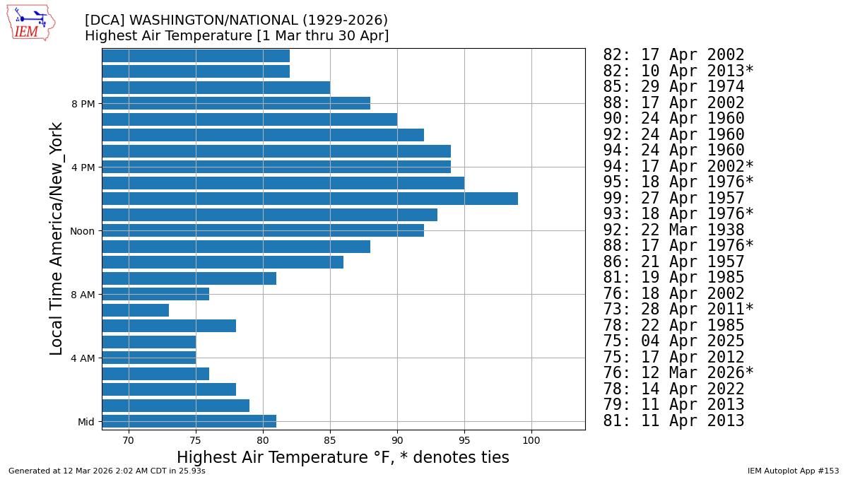
Let’s put it this way. The 76 and 75 observed at DCA at 3am and 4am would be a record for those hours in April.
-
Central PA Spring 2026 Discussion/Obs Thread
TimB replied to Voyager's topic in Upstate New York/Pennsylvania
The crazy thing is the 76 observed on the 3am hourly at DCA would be a record April high for that hour at that site, and we’re still in the first half of March.
-
Pittsburgh/Western PA WINTER ‘25/‘26
TimB replied to Burghblizz's topic in Upstate New York/Pennsylvania
High of 78 ties with 2/20/2018 and 3/5/2004 for warmest high on or before 3/7, low of 60 is the 2nd warmest low on or before 3/7 behind 1/22/1906, daily mean of 69 is the warmest daily mean ever recorded at Pittsburgh on or before March 7th. -
Pittsburgh/Western PA WINTER ‘25/‘26
TimB replied to Burghblizz's topic in Upstate New York/Pennsylvania
As of now, the high at PIT is either 78 or 79 depending on rounding. We have never reached 79 this early in the season. -
Pittsburgh/Western PA WINTER ‘25/‘26
TimB replied to Burghblizz's topic in Upstate New York/Pennsylvania
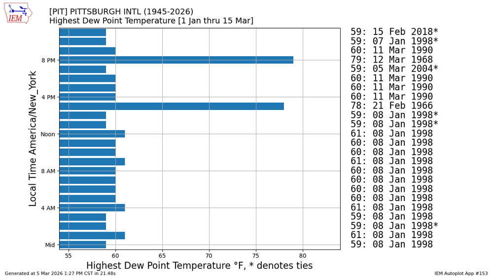
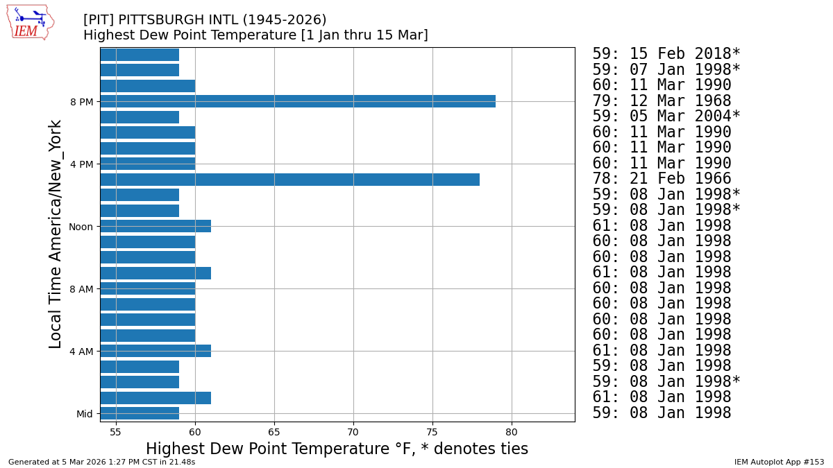
If you throw out those two erroneous data points, the highest dewpoint ever observed at PIT prior to March 15th was 61 on 1/8/1998. We could be reaching levels of humidity on Saturday that are unprecedented so early in the season.