

bobbutts
-
Posts
6,349 -
Joined
-
Last visited
Content Type
Profiles
Blogs
Forums
American Weather
Media Demo
Store
Gallery
Everything posted by bobbutts
-
-
I think your climate change post was the highlight of the day so far.
-

March 12/13/14 Blizzard/Winter Storm/WWA etc
bobbutts replied to Bostonseminole's topic in New England
Should be a clear standard for this. I'm a fan of the ruler in the snow at the end of the storm, but that is clearly not ideal for long duration or major snowstorms. I feel like adding a disclaimer that my measurements are for entertainment purposes only. -
March 12/13/14 Blizzard/Winter Storm/WWA etc
bobbutts replied to Bostonseminole's topic in New England
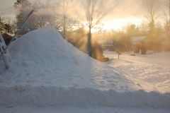
Another 3" overnight.. I'm calling it 16" total. Only cleared once (before the last 3") -
March 12/13/14 Blizzard/Winter Storm/WWA etc
bobbutts replied to Bostonseminole's topic in New England
grlevel3 http://www.grlevelx.com/grlevel3_2/ -
March 12/13/14 Blizzard/Winter Storm/WWA etc
bobbutts replied to Bostonseminole's topic in New England
Big zone of mostly 20+ totals -
March 12/13/14 Blizzard/Winter Storm/WWA etc
bobbutts replied to Bostonseminole's topic in New England
meh'd may way to 12"+ I think @dendrite will do well with the 14" at kcon -
March 12/13/14 Blizzard/Winter Storm/WWA etc
bobbutts replied to Bostonseminole's topic in New England
Someone in Bow reported 15" with 8" in 3hr. I took a nap and didn't go out there yet, does look like quite a bit more now. -
March 12/13/14 Blizzard/Winter Storm/WWA etc
bobbutts replied to Bostonseminole's topic in New England
Manchester did great. -
March 12/13/14 Blizzard/Winter Storm/WWA etc
bobbutts replied to Bostonseminole's topic in New England
Got unlucky this time, I'm at 8". Just saw spotter in Candia got 21" that's only about 15 mi east of here. -
March 12/13/14 Blizzard/Winter Storm/WWA etc
bobbutts replied to Bostonseminole's topic in New England
Dumpage at Bow Middle School for voting. -
March 12/13/14 Blizzard/Winter Storm/WWA etc
bobbutts replied to Bostonseminole's topic in New England
Finally into the good radar returns here. Was dumping for the weenie drive. 7" so far. Just noticed right across the river ~5mi away in Pembroke reporting 14".. crazy gradient if we're both accurate -
March 12/13/14 Blizzard/Winter Storm/WWA etc
bobbutts replied to Bostonseminole's topic in New England
Time to go vote in local election. Good excuse for a weenie drive. -
March 12/13/14 Blizzard/Winter Storm/WWA etc
bobbutts replied to Bostonseminole's topic in New England
I didn't venture very far from the door so it's possible there was some drifting too. -
March 12/13/14 Blizzard/Winter Storm/WWA etc
bobbutts replied to Bostonseminole's topic in New England
6" now. Flake size increased and it's accumulating very well last hour or so. -
March 12/13/14 Blizzard/Winter Storm/WWA etc
bobbutts replied to Bostonseminole's topic in New England
looks like 16" Norwich CT (social media) and 19" Milford MA (trained spotter) are the biggest reports I can see now. -
March 12/13/14 Blizzard/Winter Storm/WWA etc
bobbutts replied to Bostonseminole's topic in New England
Good stuff dying right on my doorstep.. Still a decent storm so far. -
March 12/13/14 Blizzard/Winter Storm/WWA etc
bobbutts replied to Bostonseminole's topic in New England
Near white out at times now when winds are right.. Measured 3.5" -
March 12/13/14 Blizzard/Winter Storm/WWA etc
bobbutts replied to Bostonseminole's topic in New England
128-495 and 91 getting it good here -
March 12/13/14 Blizzard/Winter Storm/WWA etc
bobbutts replied to Bostonseminole's topic in New England
Radar looking very healthy for I95 area of S. Maine up to Portland. -
March 12/13/14 Blizzard/Winter Storm/WWA etc
bobbutts replied to Bostonseminole's topic in New England
2" so far, visibility has gone down pretty low in gusts last little while here -
March 12/13/14 Blizzard/Winter Storm/WWA etc
bobbutts replied to Bostonseminole's topic in New England
use https://imgur.com/ -
March 12/13/14 Blizzard/Winter Storm/WWA etc
bobbutts replied to Bostonseminole's topic in New England
Little surprised to be underway so early with nothing on the radar, but light snow has begun here with a coating accumulated. -
Devastating tornado strikes Joplin, Missouri
bobbutts replied to Hoosier's topic in Weather Forecasting and Discussion
Nothing wrong with the basement for a severe t-storm. It's not "severe" unless it has winds 58+. I think your point would be better made if the word severe were removed. -
 Takes a bunch of energy and equipment too, but obviously it's money well spent.

